
Kruckow
| coat of arms | Germany map | |
|---|---|---|

|
Coordinates: 53 ° 54 ' N , 13 ° 14' E |
|
| Basic data | ||
| State : | Mecklenburg-Western Pomerania | |
| County : | Vorpommern-Greifswald | |
| Office : | Jarmen-Tutow | |
| Height : | 67 m above sea level NHN | |
| Area : | 35.42 km 2 | |
| Residents: | 624 (Dec. 31, 2019) | |
| Population density : | 18 inhabitants per km 2 | |
| Postal code : | 17129 | |
| Area code : | 039999 | |
| License plate : | VG, ANK, GW, PW, SBG, UEM, WLG | |
| Community key : | 13 0 75 070 | |
| Community structure: | 8 districts | |
| Office administration address: | Dr.-Georg-Kohnert-Str. 5 17126 Jarmen |
|
| Website : | ||
| Mayoress : | Elke Hempel | |
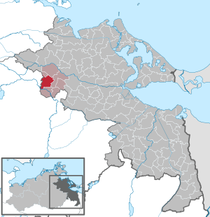
| Location of the municipality of Kruckow in the Vorpommern-Greifswald district | ||
  |
||

Kruckow is a municipality in the Vorpommern-Greifswald district. The community is located 26 kilometers southwest of the district town of Greifswald . Until January 1, 2004, the community was part of the Tutow Office and has been part of the Jarmen-Tutow Office since then .
geography
Geographical location
Kruckow is 13 km east of Demmin and 8 kilometers west of Jarmen . The community is located on a plateau sloping down to the Tollense at 10 to 20 meters above sea level , but has no prominent high points. The river Tollense forms the southern border of the municipality, with the ruin " Burg Osten " being an exception, the area of which is located in the municipality of Kruckow. In the northern area the cuckoo moat runs through an ice age glacial valley . Otherwise there are no noteworthy bodies of water, only a multitude of glacial sills . There are forested areas in the southwest and north.
Community structure
|
|
- Incorporations
The communities of Kruckow and Kartlow merged on May 31, 1999 to form the community of Kruckow. On June 13, 2004 Schmarsow was incorporated.
Neighboring communities
These are: Tutow in the north, Bentzin in the northeast, Jarmen (city) in the east, Alt Tellin in the south, Utzedel in the southwest, Siedenbrünzow in the west and Kletzin in the northwest.

history
Kruckow

Kruckow was settled at an early age, as evidenced by the three large stone graves to the west of the village, they date from the Neolithic Age around 3500 BCE.
The place was first mentioned in a document in 1249 when Bishop Wilhelm von Cammin parsed the place alongside other villages to the Kartlower church.
1498 enfeoffed Bogislaw X. Peter Podewils with Kruckow and Tentzerow.
According to the Kahlden Hufenmatrikel, Jürgen and Adam Kruckow zu Kruckow owned four Landhufen in 1631.
An atonement cross on the southwestern edge of Kruckow comes from the Middle Ages . It is hidden at the last homestead in the direction of Schmarsow. Inscriptions are illegible and no history has been passed down. The registered ground monument is one of the rare atonement crosses in Mecklenburg-Western Pomerania.

In 1712 Joachim Friedrich von Podewils sold Kruckow, along with other villages, to Commissarius Franz von Glasenapp . When the estate was divided in 1738, his son Carl Friedrich von Glasenapp received the estate. Together with his five brothers, he acquired the four lands of the Maltzahn property in Kruckow from Hans Bernd von Maltzahn. He died without an heir and his brothers Peter and Felix von Glasenapp left the goods Bentzin, Barkow and Kruckow to Major General Karl Franz von Sobeck († 1779). He had married the only daughter of Felix von Glasenapp. After a settlement, Kruckow and Barkow went to their son, Chamberlain Peter Franz Hans Ernst Freiherr von Sobeck in 1796.
According to a plan drawn up by Peter Joseph Lenné in 1840 , Karl Freiherr von Sobeck had a landscape park laid out. In 1884 a mansion was built.
The last owner of the Kruckow estate was Alexander Freiherr von Sobeck in 1945. The mansion burned down in the post-war period in 1948 and was demolished for the extraction of building material, remains can still be seen.
Marienfelde
The village was laid out in 1833 as the Vorwerk of the Kruckow estate under the owner Wilhelm von Sobeck .
Tutow village
The place was first mentioned as Tutow in 1256. Lords were u. a. the families von Horn (1397 – around 1700), von Parsenow and von Sobeck (until 1945). The dilapidated village church was demolished in 1992.

Kartlow
Kartlow was first mentioned in a document in 1245. In 1292 the princely castle, destroyed in 1630, was transferred to the von Heyden family under Bogislaw IV , who received the area as a fief in 1560 and owned the estate until 1945. The late Romanesque / early Gothic St. John's Church from 1249 was expanded and rebuilt in 1860/1870 and received a neo-Gothic tower. The Kartlow palace after plans Friedrich Hitzig is from 1856. It was after 1945 House, consumption, kindergarten and seat of LPG .
Heydenhof
The village was laid out in 1820/21 by Wichard Wilhelm von Heyden as a Vorwerk von Kartlow, the name is dedicated to the owner.
Schmarsow
Schmarsow was first mentioned in a document in 1249. The name is probably derived from the Slavic word smarž , which means morel .
Unnode
Unnode was created in 1820 when seven farmers were relocated from Kartlow.

Borgwall
Borgwall was laid out in 1750 as the Borgwall suburb . It was pertinence (ancillary property) of Gut Schmarsow, but then became an independent property. It belonged to the von Maltzahn family until 1855 , who had owned the Schmarsow estate since the 14th century. In 1855 the estate went to the von Heyden family . In 1862 Borgwall had only 4 houses but 91 inhabitants. According to the Prussian original measuring table from 1835, the Borgwall settlement was originally 700 m further south-east. It can be assumed that after the takeover by Heyden, the estate including the day laborers 'cottages was rebuilt closer to Schmarsow, as evidenced by the measuring table from 1880. At that time, the estate and site consisted of the manor house, 4 farm buildings and 5 farm workers' cottages.
- East (desert)
On the northern bank of the Tollense, opposite the castle, the village "Osten" was already at the time of the Swedish registration of 1694. It was recorded with a forester's house and several residential buildings until after 1920 (according to MTB ), but later fell into desolation. The last building, the timber-framed forester's house, burned down in 1945. Today only scattered rock debris is evidence of this.
- New Kartlow (desert)
A colony founded in 1777 in the southern Feldmark near Heidenhof and given up again in 1885.
politics
Coat of arms, flag, official seal
The municipality has no officially approved national emblem, neither a coat of arms nor a flag . The official seal is the small state seal with the coat of arms of the region of Western Pomerania . It shows an upright griffin with a raised tail and the inscription "GEMEINDE KRUCKOW".
Attractions

Buildings
→ See: List of architectural monuments in Kruckow
- Kartlower castle from 1857 by Schinkel student Friedrich Hitzig with castle park by Peter Joseph Lenné
- The Kruckow Castle, built in 1884 for Adolf Freiherr von Maltzahn , burned down in 1948.
- Schmarsow Castle : Two-storey, baroque manor house from around 1698 with two side wings, built for Philipp Joachim von Parsenow .
- Ost Castle near Schmarsow an der Tollense , relic of a moated castle
- Atonement-Kreuzstein in Kruckow, (poorly visible), one of the rare medieval ground monuments in MV
- Castle ramparts Alte Schanze and Alte Stadt near Tutow-Dorf, both from the Slav period
- Several milestones in the community

Green spaces and recreation
- Kruckower Palace Park designed by Peter Joseph Lenné .
- Large stone grave Kruckow 1 , as well as No. 2 and 3 near Marienfelde, Neolithic
- Wooded area near Burg Osten with three Bronze Age barrows, the Hexenstein, the milestone at the Ostener crossing and the Tollense lowland
Economy and Infrastructure
Companies
The community is largely agricultural. In addition, commercial and service companies also developed. Tourism and accommodation are still weakly represented, with Kartlow and Schmarsow rising.

traffic
The B 110 runs through the community. The place can be reached via the Jarmen junction of the A 20 . From 1897 to 1945 the Demminer Kleinbahnen Ost (DKBO) operated in what is now the municipality. Coming from Vanselow, it split near Schmarsow and continued north to Heidenhof and on to Plötz and south past the east to Alt Tellin. It was dismantled in 1945 as a reparation.
The rest of the road and path network has been expanded, in 2005 the Tollensebrücke was modernly renewed, until now it consisted only of a plank bridge, but it was very dilapidated and therefore closed. The corresponding connection road to Roidin was also rebuilt.
Sons and daughters (selection)
- Wilhelm von Sobeck (1799–1875), politician and landowner
Web links
- Literature about Kruckow in the state bibliography MV
- Kruckow on the pages of the Jarmen-Tutow office
Individual evidence
- ↑ Statistisches Amt MV - population status of the districts, offices and municipalities 2019 (XLS file) (official population figures in the update of the 2011 census) ( help ).
- ↑ a b c Municipality of Kruckow. (No longer available online.) Jarmen-Tutow Office, archived from the original on February 10, 2013 ; Retrieved June 27, 2013 . Info: The archive link was inserted automatically and has not yet been checked. Please check the original and archive link according to the instructions and then remove this notice.
- ↑ StBA Area: changes from 01.01. until December 31, 2004
- ^ Friedrich Wilhelm Barthold : History of Rügen and Pomerania . 4th part, 2nd volume, Friedrich Perthes, Hamburg 1845, p. 28 ( Google Books ).
- ^ Robert Klempin and Gustav Kratz : Matriculations and directories of the Pomeranian knighthood from the XIV to the XIX century . Berlin 1863, p. 312 ( Google Books ).
- ^ Heinrich Berghaus : Land book of the Duchy of Pomerania and the Principality of Rügen . Part 2, Vol. 1, W. Dietze, Anklam-Berlin 1865, pp. 145-146 ( Google Books ).
- ^ Hubertus Neuschäffer: Western Pomerania's castles and mansions. Husum Druck- und Verlagsgesellschaft 1993, ISBN 3-88042-636-8 , p. 106.
- ↑ Joachim Herrmann (ed.), Hans Holm Bielfeldt a . a .: The Slavs in Germany. History and culture of the Slavic tribes west of Oder and Neisse from the 6th to 12th centuries. (= Publications of the Central Institute for Ancient History and Archeology of the Academy of Sciences of the GDR. Vol. 14) Akademie-Verlag, Berlin 1985, p. 100.
- ^ Heinrich Berghaus : Land book of the Duchy of Pomerania and the Principality of Rügen . Part 2, Vol. 1, W. Dietze, Anklam-Berlin 1865, pp. 111-112 ( Google Books ).
- ↑ Main Statute, Section 1, Paragraph 2 (PDF).
Ahlbeck | Old Tellin | Altwarp | Altwigshagen | Anklam | Bandelin | Bargischow | Behrenhoff | Bentzin | Benz | Mountain wood | Blankensee | Blesewitz | Boldekow | Boock | Brietzig | Brünzow | Bugewitz | Buggenhagen | Butzow | Daberkow | Dargelin | Dargen | Dersekow | Ducherow | Eggesin | Fahrwalde | Ferdinandshof | Garz | Glazov | Görmin | Grambin | Grambov | Greifswald | Gribow | Gross Kiesow | Groß Luckow | Great Polzin | Gützkow | Hammer ad Uecker | Hanshagen | Heinrichswalde | Heringsdorf | Hinrichshagen | Hintersee | Iven | Jarmen | Jatznick | Comb teeth | Karlsburg | Karlshagen | Katzow | Kemnitz | Klein Bünzow | Koblentz | Korswandt | Koserow | Krackow | Krien | Kröslin | Kruckow | Krugsdorf | Krummin | Krusenfelde | Lassan | Leopoldshagen | Levenhagen | Liepgarten | Löcknitz | Loddin | Loissin | Loitz | Lubmin | Luebs | Luckow | Luetow | Medow | Meiersberg | Mellenthin | Mesekenhagen | Mölschow | Mönkebude | Murchin | Nadrensee | Neetzow-Liepen | New Boltenhagen | New Kosenow | Neuenkirchen | Neuenkirchen | Low | Papendorf | Pasewalk | Peenemünde | Penkun | Plow | Polzow | Postlow | Pudagla | Ramin | Rankwitz | Rollwitz | Rossin | Rossow | Rothemühl | Rothenklempenow | Rubenov | Rubkov | Sarnow | Sassen-Trantow | Sauzin | Schmatzin | Schönwalde | Spantekow | Stumble on the Peene | Stolpe on Usedom | Strasburg (Uckermark) | Torgelow | Trassenheide | Tutow | Ückeritz | Ueckermünde | Usedom | Square | Vogelsang-Warsin | Völschow | Wackerow | Weitenhagen | Wilhelmsburg | Wolgast | Wrangelsburg | Wusterhusen | Zemitz | Zempin | Zerrenthin | Ziethen | Zinnowitz | Zirchow | Züssow