
Wrangelsburg
| coat of arms | Germany map | |
|---|---|---|

|
Coordinates: 54 ° 1 ′ N , 13 ° 36 ′ E |
|
| Basic data | ||
| State : | Mecklenburg-Western Pomerania | |
| County : | Vorpommern-Greifswald | |
| Office : | Züssow | |
| Height : | 24 m above sea level NHN | |
| Area : | 14.99 km 2 | |
| Residents: | 234 (Dec. 31, 2019) | |
| Population density : | 16 inhabitants per km 2 | |
| Postal code : | 17495 | |
| Area code : | 038355 | |
| License plate : | VG, ANK, GW, PW, SBG, UEM, WLG | |
| Community key : | 13 0 75 145 | |
| Office administration address: | Dorfstrasse 6 17495 Züssow |
|
| Mayor : | Paul Juds | |
| Location of the community Wrangelsburg in the district of Vorpommern-Greifswald | ||
  |
||

Wrangelsburg is a municipality in the Vorpommern-Greifswald district . The community is administered by the Züssow Office , based in Züssow . The community is located southeast of the district town of Greifswald. It has 216 inhabitants (as of December 31, 2015).
geography
.jpg)

Geographical location
Wrangelsburg is located six kilometers northeast of Züssow and 17 km southeast of Greifswald . The federal highway 109 runs through the municipality . The northern part of the municipality is forested. Wrangelsburg is the smallest municipality in the office in terms of area.
Community structure
Districts
- Gladrow
- Wrangelsburg
Neighboring communities
Neu Boltenhagen in the north, Katzow in the east, Lühmannsdorf in the south-east, Karlsburg in the south, Groß Kiesow in the south-west, Weitenhagen in the west and Hanshagen in the north-west.
history
Wrangelsburg
The district of Wrangelsburg, which gives the municipality its name, was first mentioned in 1345 as "Vorwerk". In this document Reimer Nienkerken ( Neuenkirchen ) was named as the owner. On December 6, 1426, the dukes Wartislaw III enfeoffed. von Pommern-Demmin and Barnim I. von Pommern-Stettin Roloff Nienkerken (Neuenkirchen) with the village. In 1508 Gerhard and in 1603 Christoph Nienkerken were named as owners of the estate.
During the Thirty Years War , the Neuenkirchen family died out with Christoph von Neuenkirchen in 1641 . The fiefdom was given in 1649 together with the estates Groß Ernsthof and Spandowerhagen by the Swedish government to their field marshal Hermann Wrangel , who bequeathed it to his children from their third marriage in a will. It was not until 1653 that the then Swedish Governor General Carl Gustav Wrangel from Hermann Wrangel's first marriage was able to exchange this property for goods in Livonia . In order to manifest the new ownership structure, Carl Gustav Wrangel first changed the estate name to "Hohen Vorwerk" before it was changed to "Wrangelsburg" on September 19, 1653. In 1722 Wrangelsburg and Krebsow fell to the family of the Counts von Brahe, who were entitled to inheritance through Carl Gustav Wrangel's eldest daughter.
After the Thirty Years' War, a sizable rural village had developed next to the estate , in which several small hereditary tenants and craftsmen such as blacksmiths, millers, tailors, linen weavers and brewers lived. In 1865 the place had 147 inhabitants in 22 families, a school, 14 residential and 19 farm buildings. In 1928 the Wrangelsburg manor district, which had had 165 inhabitants in 1910, was dissolved and given the status of a rural community . Administratively this was subordinated to the district of Greifswald . In 1929 the Wrangelsburg estate came into the possession of Karz von Kameke through inheritance . He remained the owner of the property until the end of the Second World War , when it was expropriated in the course of the land reform in 1945. The agricultural property was divided up among new farmers and in 1952 it became an agricultural production cooperative (LPG). After the place Gladrow was incorporated into Wrangelsburg in 1946, both places had a total of 453 inhabitants in 1964. During the GDR administrative division , Wrangelsburg belonged to the Greifswald district ; after several regional reforms, the place has been administered by the Vorpommern-Greifswald district since 2011 . Wrangelsburg had 151 residents with main residence and 11 with secondary residence on December 31, 2015.
Gladrow
The place name (1406 Gladerow) comes from Slavic and means something like "place of a glador (bird of prey)". In 1597 the place covered approx. 45 hectares with three cottages. At that time, half of Gladrow belonged to the Nienkerken family, while the rest was pledged to the Greifswald consistory . When Hermann Wrangel took over Wrangelsburg in 1649, the entire Gladrow estate came under his common hand. At the end of the 17th century the village was completely surrounded by forest and was inhabited by three small tenants, two dependent farmers and a shepherd. After the fields were deserted at the end of the Thirty Years' War, the estate administration established four large farms and several boutiques . After that, the population rose steadily from 34 in 1767 to 104 in 1865. At that time Gladrow had a school, 15 residential and 29 farm buildings. In 1910 Gladrow officially had 110 inhabitants, in 1935 the place was incorporated into the rural community of Züssow . After the end of the Second World War, Gladrow came to Wrangelsburg on August 1, 1946 as a district. The LPG, founded in 1954, merged with the Wrangelsburg cooperative in 1960. At the last census on December 31, 2015, there were 51 residents in the Gladrow district with main residence and three with secondary residence.
politics
Community representation
The Wrangelsburg community has a community council with 7 members. The mayor of the community and, at the same time, the chairman of the community council with voting rights is Andreas Juds, who was confirmed in office as an individual applicant in June 2014. Other members of the community council are Elke Schöndorf as a representative of the electoral community, who acts as the first deputy mayor and the former district administrator of the Ostvorpommern district Herbert Kautz is the only representative of the CDU and also acts as the second deputy mayor. The remaining 4 community representatives were elected as individual applicants.
coat of arms
|
|
Blazon : "In blue a floating golden wall made of three ashlar layers with three battlements made of two ashlar layers each."
The coat of arms and the flag were designed by Greifswald historian Ivo Asmus . It was approved together with the flag on September 6, 2001 by the Ministry of the Interior and registered under No. 249 of the coat of arms of the state of Mecklenburg-Western Pomerania. |
| Reasons for the coat of arms: The figure borrowed from the symbol of the Wrangel family - they carried a coat of arms showing a black wall with three battlements in silver - is intended to commemorate the governor-general of Swedish Pomerania, who gave the place his name and dated There, for a time, carried out his government business at the representatively designed castle. The changed tinging in the Swedish colors creates a reference to the former Swedish times. |
flag

The flag shows the yellow figure of the municipal coat of arms on a blue cloth in the middle. The heraldic figure takes up half the height and half the length of the flag cloth. The length of the flag cloth is related to the height as 8: 5.
Official seal
The official seal shows the municipal coat of arms with the inscription "GEMEINDE WRANGELSBURG".
Culture and sights


Theaters and museums
The association "Paper and Printing" deals with the production of vegetable, handmade and recycled papers. The paper factory, which was expanded from an old sheepfold, was inaugurated in 2002.
Buildings
→ See: List of architectural monuments in Wrangelsburg
- Carl Gustav Wrangel had the permanent house, probably built by Christoph von Neuenkirchen around 1606, converted from a renaissance castle into a baroque mansion. In 1689 he bequeathed the castle to his son-in-law Leonard Johan Wittenberg, who was widowed before Wrangel's death. After the death of his childless daughter in 1720 and her husband in 1722, Wrangelsburg and Krebsow fell to the family of the Counts of Brahe, who were entitled to inheritance through Carl Gustav Wrangel's eldest daughter.
- The castle fell into disrepair in the 18th century because the owners at that time (Count Brahe, from 1769 Count Malte Friedrich von Putbus , from 1773 the von Normann family until 1816) did not live in and maintain it themselves. It was partially demolished from 1803 onwards due to dilapidation.
- In 1816 the estate came to the Laug family, in 1843 it was Ludwig Laug who sold it to Johannes Carl Leopold von Homeyer (ennobled in 1865) in 1862. In 1880 the new manor house , today's Wrangelsburg Castle, was built. The client was Johannes Carl Leopold von Homeyer.
- The estate came into the possession of the von Kameke family in 1929 through inheritance. The family was expropriated after World War II and the manor was temporarily used by the Soviet military administration. From around 1946 it was used for a time as a home for the physically handicapped by “Bethesda” and then as a state children's home until 1996.
- Until 2012, the castle building was used by the municipality, which bought it in 1999 to prevent further deterioration. Since that time it has been partially renovated again and again. From the outside it is still in poor condition, but the first floor has been renovated and its substance is in good condition. The EWE Group bought the lock in 2012 : EWE wants to rebuild the lock by 2017 as it was until 1945.
- The so-called office building is located southeast of the manor house . There is evidence that it dates from the 16th century and was then the gatehouse of the "Wrangelsburg" castle. Under the owner Homeyer, a grain merchant in Wolgast, the building was used as a grain store. Later the house was used as a barracks for the reapers ( seasonal harvest workers ) from Poland and Galicia , which is why it was called the "reaper's house" in the village.
- There are two sandstone replicas at the left entrance , the originals are in the Pomeranian State Museum in Greifswald. The figures were previously attached to the north gable. The exterior of the building no longer corresponds to the state of the 16th century, as it was plastered over in a modern way and the doorways and other parts of the building were significantly changed. The current bat dormers were only installed in the 19th century.
- Since 2013 the gatehouse has been restored on behalf of the owner in coordination with the monument office. The aim is to bring the only preserved gatehouse of a late baroque four-sided complex in Mecklenburg-Western Pomerania into public interest. Visits are also to be offered there for those interested. From 2016 there will also be the possibility of renting a holiday apartment.
- Mausoleum of the Laug family from 1842 in the cemetery west of Wrangelsburg Manor
Green spaces and recreation
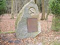
- The castle park with the castle lake, the memorial for the fallen soldiers of the First World War and the stone bar to the adjacent forest area are in good condition. In the adjacent forest is the separate cemetery of the landowners. The cycling and hiking trail leading eastwards runs through the forest to the Great and Small Black Lake, as well as further to the Slavic double castle wall "Wrangelsburg", which is no longer in the municipality. Components:
- Wrangelsburg Manor Park, English landscape park east of the castle
- Burgwall "Wrangelsburg", large Slavic double castle complex in the forest 2 km to the east in the Jägerhof district
- Homeyer and Kameke are buried approx. 20 m east of the castle lake
- Wrangelsburg war memorial (around 1920) in the eastern part of the park
- Stone bars between the landscaped park and forest

Wrangelsburg Castle (2007)

Wrangelsburg Castle Park

Wrangelsburg castle wall

Homeyer / Kameke Wrangelsburg's grave
Wrangelsburg War Memorial


Personalities
Personalities who worked in this village
- Kartz von Kameke-Streckenthin (1866–1942), potato grower
- Carl Gustav Wrangel (1613–1676), Swedish general and statesman, Reichsmarschall, Reichsadmiral, President of the War College, squire and namesake of the place Wrangelsburg
See also
literature
- Heinrich Berghaus : Land book of the Duchy of Pomerania and the Principality of Rügen. IV. Part Volume II, Anklam 1868 Google Books p. 1131 for Wrangelsburg (Zarnekow parish)
Web links
- Literature about Wrangelsburg in the state bibliography MV
- Wrangelsburg community on the Amt-Züssow website
- Information about the community at www.vorpommern-sued.de
Individual evidence
- ↑ Statistisches Amt MV - population status of the districts, offices and municipalities 2019 (XLS file) (official population figures in the update of the 2011 census) ( help ).
- ^ Züssow Office, residents of the Züssow administrative area, as of December 31, 2015
- ^ Greifswald and its surroundings , Akademieverlag Berlin, 1968, p. 187
- ^ Manfred Niemeyer: Ostvorpommern. Collection of sources and literature on place names. Vol. 2: Mainland. (= Greifswald contributions to toponymy. Vol. 2), Ernst-Moritz-Arndt University of Greifswald, Institute for Slavic Studies, Greifswald 2001, ISBN 3-86006-149-6 . P. 147.
- ↑ Julius v. Bohlen: History of the noble, baronial and counts of the Bohlen. Vol. 2: Document book (printed instead of handwriting.) , Stralsund 1859–1875. Pp. 17-18, no. 54.
- ↑ Ivo Asmus: The Count's Testament - The Pomeranian possessions of Carl Gustav Wrangel after death, formyndarräfst and reduction. In: Ivo Asmus, Heiko Droste, Jens E. Olesen (eds.): Common acquaintances: Sweden and Germany in the early modern period. (= Publications of the Chair for Nordic History . Vol. 4; also history. Research and Science. Vol. 2). LIT Verlag, Münster / Hamburg 2003, ISBN 3-8258-7150-9 . Pp. 193-224, here p. 204 f.
- ↑ Ivo Asmus: The Count's Testament - The Pomeranian possessions of Carl Gustav Wrangel after death, formyndarräfst and reduction. In: Ivo Asmus, Heiko Droste, Jens E. Olesen (eds.): Common acquaintances: Sweden and Germany in the early modern period. (= Publications of the Chair for Nordic History. Vol. 4; also history. Research and Science. Vol. 2). LIT Verlag, Münster / Hamburg 2003, ISBN 3-8258-7150-9 , p. 222 f.
- ^ Heinrich Berghaus : Land book of the Duchy of Pomerania and the Principality of Rügen, IV. Part Volume II, Anklam 1868 p. 1120 u. 1131
- ↑ a b Züssow office, residents of the Züssow administrative area, as of December 31, 2015
- ^ Greifswald and its surroundings , Akademieverlag Berlin, 1968, p. 186
- ^ Heinrich Berghaus : Land book of the Duchy of Pomerania and the Principality of Rügen. IV. Part Volume II, Anklam 1868, p. 368 and 374
- ↑ http://www.ostsee-zeitung.de/Extra/Serien/Kommunalwahl-2014/Vorpommern-Greifswald/Juds-gewinnt-Stichwahl-knapp-gegen-Hey
- ^ Editing of Neues Deutschland: Ost-Vorpommern (Neues Deutschland). Retrieved February 28, 2019 .
- ↑ Local authority. Retrieved February 28, 2019 .
- ↑ Hans-Heinz Schütt: On shield and flag production office TINUS, Schwerin 2011, ISBN 978-3-9814380-0-0 , p. 376/377.
- ↑ a b main statute § 1 (PDF).
- ↑ http://www.papier-druck.beepworld.de/
- ↑ Ivo Asmus: The Count's Testament - The Pomeranian possessions of Carl Gustav Wrangel after death, formyndarräfst and reduction. In: Ivo Asmus, Heiko Droste, Jens E. Olesen (eds.): Common acquaintances: Sweden and Germany in the early modern period. (= Publications of the Chair for Nordic History. Vol. 4; also history. Research and Science. Vol. 2). LIT Verlag, Münster / Hamburg 2003, ISBN 3-8258-7150-9 , p. 222 f.
- ↑ Information on the community at www.vorpommern-sued.de
Ahlbeck | Old Tellin | Altwarp | Altwigshagen | Anklam | Bandelin | Bargischow | Behrenhoff | Bentzin | Benz | Mountain wood | Blankensee | Blesewitz | Boldekow | Boock | Brietzig | Brünzow | Bugewitz | Buggenhagen | Butzow | Daberkow | Dargelin | Dargen | Dersekow | Ducherow | Eggesin | Fahrwalde | Ferdinandshof | Garz | Glazov | Görmin | Grambin | Grambov | Greifswald | Gribow | Gross Kiesow | Groß Luckow | Great Polzin | Gützkow | Hammer ad Uecker | Hanshagen | Heinrichswalde | Heringsdorf | Hinrichshagen | Hintersee | Iven | Jarmen | Jatznick | Comb teeth | Karlsburg | Karlshagen | Katzow | Kemnitz | Klein Bünzow | Koblentz | Korswandt | Koserow | Krackow | Krien | Kröslin | Kruckow | Krugsdorf | Krummin | Krusenfelde | Lassan | Leopoldshagen | Levenhagen | Liepgarten | Löcknitz | Loddin | Loissin | Loitz | Lubmin | Luebs | Luckow | Luetow | Medow | Meiersberg | Mellenthin | Mesekenhagen | Mölschow | Mönkebude | Murchin | Nadrensee | Neetzow-Liepen | New Boltenhagen | New Kosenow | Neuenkirchen | Neuenkirchen | Low | Papendorf | Pasewalk | Peenemünde | Penkun | Plow | Polzow | Postlow | Pudagla | Ramin | Rankwitz | Rollwitz | Rossin | Rossow | Rothemühl | Rothenklempenow | Rubenov | Rubkov | Sarnow | Sassen-Trantow | Sauzin | Schmatzin | Schönwalde | Spantekow | Stumble on the Peene | Stolpe on Usedom | Strasburg (Uckermark) | Torgelow | Trassenheide | Tutow | Ückeritz | Ueckermünde | Usedom | Square | Vogelsang-Warsin | Völschow | Wackerow | Weitenhagen | Wilhelmsburg | Wolgast | Wrangelsburg | Wusterhusen | Zemitz | Zempin | Zerrenthin | Ziethen | Zinnowitz | Zirchow | Züssow