
Ostvorpommern district
| coat of arms | Germany map |
|---|---|

|

Coordinates: 53 ° 56 ' N , 13 ° 40' E |
| Basic data (as of 2011) | |
| Existing period: | 1994-2011 |
| State : | Mecklenburg-Western Pomerania |
| Administrative headquarters : | Anklam |
| Area : | 1,900 km 2 |
| Residents: | 105,036 (Dec. 31, 2010) |
| Population density : | 55 inhabitants per km 2 |
| License plate : | Original packaging |
| Circle key : | 13 0 59 |
| Circle structure: | 88 parishes |
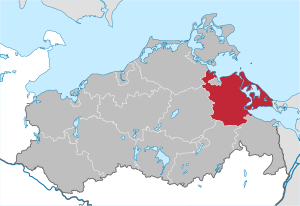
| Location of the district of Ostvorpommern in Mecklenburg-Western Pomerania | |
  |
|
The district of Ostvorpommern was a district in Mecklenburg-Western Pomerania , which became part of the district of Vorpommern-Greifswald in the course of the district reform in 2011 .
geography
The western part of the Baltic Sea island of Usedom belonged to the district area (the eastern part belongs to Poland). Neighboring districts were the Uecker-Randow district in the southeast, the Mecklenburg-Strelitz district in the south and the Demmin and North Western Pomerania districts in the west . The Hanseatic city of Greifswald protruded from the Baltic Sea in the north into the district area.
The landscape is determined by moraines, moors ( Peenetalmoor , Ziesebruch , Thurbruch ) and, above all, the coastal location on the Baltic Sea , Bodden waters ( Greifswalder Bodden , Peenestrom , Krumminer Wiek, Achterwasser ) and the Stettiner Haff . The most important river is the Peene .
history
The district of Ostvorpommern was created during the district reform in Mecklenburg-Western Pomerania on June 12, 1994 by merging the former districts of Anklam , Greifswald and Wolgast .
For an administrative reform and the intended creation of new great districts in Mecklenburg-Western Pomerania in 2009, the considerations of the state government initially went to merging the district as a whole into a new "district of South Western Pomerania". After the judgment of the state constitutional court of July 26, 2007, the original reform law could not be implemented as it was incompatible with the state's constitution.
In the course of a new district reform in 2011 , the Ostvorpommern district finally became part of the new Vorpommern-Greifswald district with the district town of Greifswald.
politics
District council
The district council of the Ostvorpommern district last consisted of 53 members. From the election of June 7, 2009 to September 3, 2011, it was composed as follows:
| Political party | Seats |
|---|---|
| CDU | 18 (–7) |
| The left | 12 (+2) |
| SPD | 7 (-1) |
| Voter communities | 6 (+1) |
| FDP | 4 (+2) |
| NPD | 4 (+2) |
| Green | 2 (+1) |
The district (constituency number 59) consisted of 143 electoral districts with 91,492 eligible voters. In 2009, 46,115 voters went to the polls, casting 4909 invalid and 130,359 valid votes. This corresponds to a turnout of 50.4% (all data from 2009, provisional result).
More information on the electoral process and legal provisions : District Council (Mecklenburg-Western Pomerania)
coat of arms
|
|
Blazon : "In gold an upright, red-tongued black griffin with a raised tail."
The coat of arms and the flag were based on an idea by Levenhagener Dr. Norbert Buske and designed by Uwe Christoffer from Schwerin . It was approved together with the flag on February 20, 1998 by the Ministry of the Interior and registered under the number 143 of the coat of arms of the state of Mecklenburg-Western Pomerania. |
| Reasons for the coat of arms: The coat of arms is linked to the black griffin, one of the color variants of the emblem of the Pomeranian griffin family, to the coat of arms symbol of the Wolgast line of the ducal house until 1500 for the countries of Wolgast and Barth. For the design of the griffin motif in the district coat of arms, a deliberate departure was made from the form handed down in seals and coats of arms depictions from the 15th and 16th centuries, and the griffin design was used, as defined in 1929 by the Prussian State Ministry for the middle coat of arms of the province of Pomerania was, and how it can also be found in the Mecklenburg-Western Pomerania coat of arms. |
flag

The flag is made of yellow cloth. In the middle it is covered with the figure of the district coat of arms: with an upright, red-tongued black griffin with a raised tail. The figure occupies seven ninths the height of the flag cloth. The length of the flag cloth is related to the height as 5: 3.
cities and communes

(Population figures on December 31, 2010)
- Anklam , City (13,433)
- Heringsdorf (9363)
Offices with official municipalities / cities
Headquarters of the official administration *
Territory changes
In the years since 1994, extensive area changes have taken place in the area of the Ostvorpommern district as in the entire state of Mecklenburg-Western Pomerania.
After the regional reform was completed on January 1, 2005, the original 14 offices became seven offices. The city of Wolgast and the municipality of Zinnowitz lost their freedom of office. The number of municipalities decreased from 110 to 96. As a result of further incorporations and dissolution in the course of 2009/2010, the number of municipalities decreased to 90.
Office dissolutions, office mergers
- Merger of the formerly free municipality of Zinnowitz with the office at An der Peene to form the new office of Usedom-Nord (January 1, 2005)
- Incorporation of the offices Ahlbeck to Stettiner Haff , Am Schmollensee and Usedom-Mitte island into the Usedom-Süd office (January 1, 2005)
- Incorporation of the offices of Gützkow and Ziethen into the office of Züssow (January 1, 2005)
- Change the city Lassan and communities Buggenhagen and Pulow from the Office Ziethen in the Am Peenestrom (1 January 2005)
- Incorporation of the previously free city of Wolgast into the Am Peenestrom Office (January 1, 2005)
- Change the community Kröslin from the Am Peenestrom in the office Lubmin (1 January 2005)
- Dissolution of the offices of Ducherow , Krien and Spantekow - formation of the new office of Anklam-Land (January 1, 2005)
Incorporation, new congregations
- Dissolution of the municipality of Zinzow - incorporation into Boldekow (January 1, 1999)
- Dissolution of the Steinmocker community - incorporation into Neetzow (June 13, 1999)
- Dissolution of the community of Groß Petershagen - incorporation into Wackerow (June 13, 1999)
- Dissolution of the Neppermin community - incorporation into Benz (May 22, 2004)
- Dissolution of the Breechen community - incorporation into Gützkow (June 13, 2004)
- Dissolution of the Schwerinsburg community - incorporation into Löwitz (June 13, 2004)
- Dissolution of the Nerdin community - incorporation into Medow (June 13, 2004)
- Dissolution of the municipality of Kammin - incorporation into Behrenhoff (January 1, 2005)
- Dissolution of the community Groß Ernsthof - incorporation into Rubenow (January 1, 2005)
- Dissolution of the municipality of Ranzin - incorporation into Züssow (January 1, 2005)
- Dissolution of the municipalities of Ahlbeck and Bansin as well as the non-official municipality of Heringsdorf - new formation of the non-official municipality Dreikaiserbäder (January 1, 2005)
- Dissolution of the communities of Morgenitz and Mellenthin - new formation of the community of Mellenthin (January 1, 2005)
- Dissolution of the Pulow community - incorporation into Lassan (June 7, 2009)
- Dissolution of the communities of Löwitz and Rathebur - incorporation into Ducherow (June 7, 2009)
- Dissolution of the communities Drewelow and Japenzin - incorporation into Spantekow (June 7, 2009)
- Dissolution of the municipality of Pelsin - incorporation according to Anklam (January 1, 2010)
- Dissolution of the community of Lüssow - incorporation into Gützkow (January 1, 2010)
- Dissolution of the municipality of Wietstock - incorporation into Altwigshagen (January 1, 2011)
Change of district
- The community of Lübs moved to the district of Uecker-Randow (January 1, 1998).
- The municipality of Wietstock moved to the district of Uecker-Randow (January 1, 2011).
Change of office
- The administrative seat of the Landhagen office changed from the independent city of Greifswald to the municipality of Neuenkirchen (August 1, 1999).
Name changes
- from Stolpe to Stolpe on Usedom (January 15, 1996)
- from Office Wolgast-Land to Office Am Peenestrom (January 1, 2005)
- from Dreikaiserbäder to Heringsdorf (January 1st, 2006)
License Plate
On June 12, 1994, the district was assigned the distinctive ANK . On October 24, 1994, the identifier was changed to OVP . This was imprinted on the license plates in the Vorpommern-Greifswald district with the exception of the Hanseatic City of Greifswald until January 31, 2012. The abbreviation can be used again. This decision is incumbent on the district, which has not made use of this option to this day.
Web links
Individual evidence
- ↑ Judgment of the State Constitutional Court of July 26, 2007 (PDF; 269 kB)
- ↑ Page no longer available , search in web archives:
- ↑ Page no longer available , search in web archives: Preliminary result of the district council election of June 8, 2009 - State Statistical Office MV
- ↑ Hans-Heinz Schütt: On shield and flag production office TINUS, Schwerin 2011, ISBN 978-3-9814380-0-0 , p. 354/355.
- ↑ Mecklenburg-Western Pomerania Statistical Office - population development of the districts and municipalities 2010 (PDF; 522 kB)
Independent cities
State capital Schwerin |
Greifswald |
Rostock |
Stralsund |
Wismar |
Neubrandenburg
Districts of
Ostvorpommern |
Rügen |
North Western Pomerania |
Bad Doberan |
Guestrow |
Northwest Mecklenburg |
Ludwigslust |
Parchim |
Müritz |
Demmin |
Mecklenburg-Strelitz |
Uecker-Randow