
Zirchow
| coat of arms | Germany map | |
|---|---|---|

|
Coordinates: 53 ° 53 ' N , 14 ° 8' E |
|
| Basic data | ||
| State : | Mecklenburg-Western Pomerania | |
| County : | Vorpommern-Greifswald | |
| Office : | Usedom-South | |
| Height : | 15 m above sea level NHN | |
| Area : | 9.53 km 2 | |
| Residents: | 561 (Dec. 31, 2019) | |
| Population density : | 59 inhabitants per km 2 | |
| Postal code : | 17419 | |
| Area code : | 038376 | |
| License plate : | VG, ANK, GW, PW, SBG, UEM, WLG | |
| Community key : | 13 0 75 152 | |
| Office administration address: | Markt 1 17406 Usedom |
|
| Mayor : | Gerd Wendlandt | |
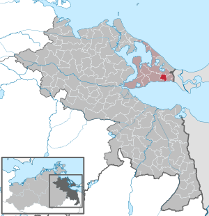
| Location of the municipality of Zirchow in the Vorpommern-Greifswald district | ||
  |
||

Zirchow is a municipality located south of the Baltic Sea coast on the island of Usedom in the so-called Achterland , right on the banks of the Stettiner Haff . The municipality is administered by the Usedom-Süd office based in the city of Usedom . Until 2005, the community belonged to the Ahlbeck-Stettiner Haff district.
Geography and traffic
Zirchow is located on the north bank of the Szczecin Lagoon on the B 110 in the Usedom Island Nature Park . The Heringsdorf seaside resort is located about six kilometers north of the village . In the east is the municipality of Garz and one of two border crossings to Poland for motor vehicles on the island of Usedom. Part of Heringsdorf Airport is in the municipality.
The district of Kutzow had a stop on the Ducherow – Ahlbeck railway, which was closed in 1945 .
The place is connected to the partially paved cycle path network of Usedom, so that the city of Usedom (15 kilometers), Garz (2.5 kilometers), Kamminke (six kilometers) and the Baltic seaside resorts of Bansin (twelve kilometers), Heringsdorf (ten kilometers) and Ahlbeck (eight kilometers) and Swinoujscie (nine kilometers), which is now part of Poland , can sometimes be reached without using the roads.
Community structure
|
Districts:
|
Desolations and living spaces:
|
history
Kutzow
1256 the place was mentioned as Cussove in a document of Duke Barnim I of Pomerania . Previous documents in favor of the Grobe monastery were classified as forgeries.
Zirchow
Neolithic finds near Kutzow testify to an early settlement in the area. To the northeast of the municipality, in the vicinity of the Sennin desert (municipality of Korswandt ), there are several burial mounds from the Bronze Age and from the time of Slavic settlement in the Middle Ages .
The document dated 1239 with the alleged first mention of Zirchow and another dated 1247 are forgeries from the 14th century. In 1256 the place was mentioned as a circhove in a document from Duke Barnim I of Pomerania . The name means something like Kirchdorf. The place came in the last decades of the 13th century to the Stolpe monastery , because in 1305 Bogislaw IV confirmed the monastery ownership. The St. Jacobus Church , one of the oldest churches on Usedom, was probably also built during this time and is known as the oldest mission church in Usedom. In 1417, Bishop Magnus von Cammin subordinated the church to the Pudagla Monastery . In 1468 Zirchow was pledged to Pudagla together with Korswandt and Sennin. The redemption did not take place. After the introduction of the Reformation in Pomerania in 1534, the monastery property was secularized in 1535 and converted into the ducal office of Pudagla.
With the Peace of Westphalia in 1648, Zirchow, like the entire island of Usedom, became part of Swedish Pomerania . In the Greifswald State Archives there is a matriculation card from Zirchow, which was created at the Swedish Land Registry of Western Pomerania . Apart from the church, only a few buildings are shown near the village.
In 1713, Prussia occupied the entire island of Usedom, which officially passed into Prussian possession in 1720 after the Treaty of Stockholm . In 1779 in the parish village of Zirchow, in addition to the pastor, the sexton and the pastor's widow, there were two half-farmers , one Kossät , four Büdner and a wood-keeper.
After the administrative reform in 1815, Zirchow came to the Prussian province of Pomerania and belonged to the district of Usedom-Wollin from 1818 to 1945 . Until the lifting of the mill compulsory in the course of the Stein-Hardenberg reforms in 1810, the Zirchower had to have their grain milled in the Garzer mill. In the measuring table sheet from 1835 of the Prussian first recording , small farmsteads can be seen along the street. By 1863 one of the two half-farms had been parceled out, and the number of Büdner jobs had grown to 19. The place now had two windmills . The population rose from 264 in 1863 to 319 in 1871. In 1880 the village had expanded further and now had a cemetery in the direction of Kutzow, because the churchyard at the church was closed. The two Dutch windmills were no longer on the map from 1920.
In 1929 the Kutzow estate was dissolved and incorporated into Zirchow. This also brought the stopping point on the Ducherow-Heringsdorf railway line , which had existed since 1876, to the community.
After 1945, as a result of the land reform and the liquidation of the Kutzow estate, new farmer settlements from Zirchow in the direction of Kutzow were created, so that a structural connection was created between the two villages. From 1945 to 1952, the municipality, with the part of the district of Usedom-Wollin that remained in Germany after the Second World War , formed the district of Usedom in the state of Mecklenburg . This was in 1952 in the district of Wolgast in District Rostock on. 1971 Zirchow seat of the newly founded association of municipalities Thurbruch. A polytechnic high school was set up in the village for the associated communities.
The community has belonged to the state of Mecklenburg-Western Pomerania since 1990. From 1994 it belonged to the district of Ostvorpommern , which was added to the district of Vorpommern-Greifswald in 2011 .

politics
Coat of arms, flag, official seal
The municipality has no officially approved national emblem, neither a coat of arms nor a flag . The official seal is the small state seal with the coat of arms of the region of Western Pomerania . It shows an upright griffin with a raised tail and the inscription "GEMEINDE ZIRCHOW * LANDKREIS VORPOMMERN-GREIFSWALD".
Attractions
- St. Jacobus Church , late Gothic brick and stone church from the 13th century. It houses medieval wall paintings and is the oldest preserved church building on the island.
- A local architectural peculiarity are the patented steel segments used as garden fences in the village and the neighboring communities, which until the 1960s formed the sectional taxiway of the Heringsdorf airport, which was then used by the military as Garz airfield.
- The Thurbruch , one of the largest fen areas in northern Germany, partly a nature reserve, is located west of the municipality.
- Airport miniature world in the building of Heringsdorf Airport
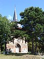
St. Jacobus Church in Zirchow

Fence made of patent steel plates


literature
- Heinrich Berghaus : Land book of the Duchy of Pomerania and the Principality of Rügen. Part II, Volume 1, Anklam 1865, p. 572 ( online )
Web links
Individual evidence
- ↑ Statistisches Amt MV - population status of the districts, offices and municipalities 2019 (XLS file) (official population figures in the update of the 2011 census) ( help ).
- ^ Pomeranian document book . Vol. II, No. 621.
- ^ Robert Burkhardt : Chronicle of the island of Usedom. Section 2: Until the end of the Reformation (1535). W. Fritzsche, Swinemünde 1909, p. 117.
- ^ Pomeranian document book . Vol. I, No. 365, 453.
- ^ Pomeranian document book . Vol. II, No. 621.
- ^ A b Manfred Niemeyer: Ostvorpommern I. Sources and literature collection on the place names. Vol. 1: Usedom. (= Greifswald contributions to toponymy. Vol. 1), Ernst-Moritz-Arndt University of Greifswald, Institute for Slavic Studies, Greifswald 2001, ISBN 3-86006-149-6 . P. 10 ff.
- ^ Hermann Hoogeweg : The founders and monasteries of the province of Pomerania. Vol. 2. Leon Saunier, Stettin 1925, p. 706.
- ^ Pomeranian document book . Vol. IV, No. 2267.
- ^ Hermann Hoogeweg : The founders and monasteries of the province of Pomerania. Vol. 2. Leon Saunier, Stettin 1925, p. 365, 706.
- ↑ Görke (Görcken, Giörken) Kutzow, Lütebock, Zirchow Office / District of Usedom. In: GeoGreif Geographical Collections. Retrieved September 9, 2014 .
- ↑ Ludwig Wilhelm Brüggemann : Detailed description of the current state of the Royal Prussian Duchy of Western and Western Pomerania. Part I: General introduction and description of the Prussian West Pomerania. Stettin 1779, p. 253.
- ↑ Ludwig Wilhelm Brüggemann : Detailed description of the current state of the Royal Prussian Duchy of Western and Western Pomerania. Part I: General introduction and description of the Prussian West Pomerania. Stettin 1779, p. 258.
- ↑ a b Wilhelm Ferdinand Gadebusch: Chronicle of the island of Usedom. W. Dietze, Anklam 1863, p. 259.
- ^ The municipalities and manor districts of the Pomerania province and their people. Edited and compiled by the Royal Statistical Bureau from the original materials of the general census of December 1, 1871. In: Königliches Statistisches Bureau (Hrsg.): The communities and manor districts of the Prussian state and their population. tape III , 1874, ZDB -ID 2059283-8 , p. 18 ( digitized version ).
- ↑ Rolf Jehke: District Dargen. In: Territorial changes in Germany and German administered areas 1874–1945. Retrieved September 9, 2014 .
- ^ History of Zirchow on the island of Usedom. Retrieved October 17, 2015 .
- ↑ Main Statute, Section 1, Paragraph 3 (PDF).
- ↑ Ev. Parish of Zirchow. In: Website of the Greifswald church district . Archived from the original on February 8, 2012 ; Retrieved July 29, 2014 .
Ahlbeck | Old Tellin | Altwarp | Altwigshagen | Anklam | Bandelin | Bargischow | Behrenhoff | Bentzin | Benz | Mountain wood | Blankensee | Blesewitz | Boldekow | Boock | Brietzig | Brünzow | Bugewitz | Buggenhagen | Butzow | Daberkow | Dargelin | Dargen | Dersekow | Ducherow | Eggesin | Fahrwalde | Ferdinandshof | Garz | Glazov | Görmin | Grambin | Grambov | Greifswald | Gribow | Gross Kiesow | Groß Luckow | Great Polzin | Gützkow | Hammer ad Uecker | Hanshagen | Heinrichswalde | Heringsdorf | Hinrichshagen | Hintersee | Iven | Jarmen | Jatznick | Comb teeth | Karlsburg | Karlshagen | Katzow | Kemnitz | Klein Bünzow | Koblentz | Korswandt | Koserow | Krackow | Krien | Kröslin | Kruckow | Krugsdorf | Krummin | Krusenfelde | Lassan | Leopoldshagen | Levenhagen | Liepgarten | Löcknitz | Loddin | Loissin | Loitz | Lubmin | Luebs | Luckow | Luetow | Medow | Meiersberg | Mellenthin | Mesekenhagen | Mölschow | Mönkebude | Murchin | Nadrensee | Neetzow-Liepen | New Boltenhagen | New Kosenow | Neuenkirchen | Neuenkirchen | Low | Papendorf | Pasewalk | Peenemünde | Penkun | Plow | Polzow | Postlow | Pudagla | Ramin | Rankwitz | Rollwitz | Rossin | Rossow | Rothemühl | Rothenklempenow | Rubenov | Rubkov | Sarnow | Sassen-Trantow | Sauzin | Schmatzin | Schönwalde | Spantekow | Stumble on the Peene | Stolpe on Usedom | Strasburg (Uckermark) | Torgelow | Trassenheide | Tutow | Ückeritz | Ueckermünde | Usedom | Square | Vogelsang-Warsin | Völschow | Wackerow | Weitenhagen | Wilhelmsburg | Wolgast | Wrangelsburg | Wusterhusen | Zemitz | Zempin | Zerrenthin | Ziethen | Zinnowitz | Zirchow | Züssow