Leopoldshagen
| coat of arms | Germany map | |
|---|---|---|

|
Coordinates: 53 ° 46 ' N , 13 ° 54' E |
|
| Basic data | ||
| State : | Mecklenburg-Western Pomerania | |
| County : | Vorpommern-Greifswald | |
| Office : | At the Szczecin Lagoon | |
| Height : | 6 m above sea level NHN | |
| Area : | 19.56 km 2 | |
| Residents: | 640 (Dec. 31, 2019) | |
| Population density : | 33 inhabitants per km 2 | |
| Postal code : | 17375 | |
| Area code : | 039774 | |
| License plate : | VG, ANK, GW, PW, SBG, UEM, WLG | |
| Community key : | 13 0 75 075 | |
| Office administration address: | Stettiner Strasse 1 17367 Eggesin |
|
| Website : | ||
| Mayor : | Werner Hackbarth | |
| Location of the municipality of Leopoldshagen in the Vorpommern-Greifswald district | ||
Leopoldshagen is a municipality in the district of Vorpommern-Greifswald in Mecklenburg-Western Pomerania (Germany). The community is administered by the Am Stettiner Haff office based in Eggesin .
geography
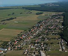
The community is located on the northwestern edge of the Anklamer Heide , about 16 kilometers from the district town of Anklam. Leopoldshagen is oriented as a typical street-row village on the main street, with a parallel street running south forming a second building line. The town's church is surrounded by the main road like an island.
The approximately three kilometers wide Haffwiesen separate Leopoldshagen from the Stettiner Haff .
The Anklamer Torfmoor (also called Anklamer Stadtbruch ), a protected wetland area, starts to the northwest of Leopoldshagen , from the western shore of the Haff to Anklam.
Districts
- Leopoldshagen
- Grünberg
- Hoheheide
- Mörkerhorst
- Cool place
history
On the orders of King Friedrich II of Prussia , the place was laid out in 1748 by the master builder Knüppel as an elongated street- row village and settled with 30 colonists. 29 colonists came from Mecklenburg-Strelitz and one family from Swedish Pomerania . First, 30 farms were created after the large oak forest had been cleared. 18 of these courtyards with their gable-facing residential buildings have been preserved.
In 1752 the place was named after Prince Leopold Maximilian von Anhalt-Dessau .
Despite difficult cultivation, the place grew and a small half-timbered church was built in 1754 and in 1763 the first pastor came to Leopoldshagen. The colonists were obliged to build double houses on the opposite side of the street, the so-called Büdner side , in order to settle more people. From the middle of the 19th century, the so-called back row was created.
In 1896 the small train station and the railway connection were built. The Mecklenburg-Pomerania Narrow Gauge Railway (MPSB) had its own track connection from Leopoldshagen to Anklam. In April 1945 the scheduled train service on the Anklam – Leopoldshagen line ended and the line was dismantled.
Leopoldshagen belonged to the district of Anklam . The wide village street with the church in the middle separated the farmers on the north side from the Büdners and craftsmen on the other side of the street, which is partly still visible today in the building structure. The small-scale structures disappeared after 1945 and two agricultural production cooperatives (LPG) were founded. The cultural associations that still exist today, the sports association; DTSV “Blau-Weiß 58” and Carnival Association; "Le-Ha" were founded by the village club chairman Max Eckhardt.
The primary school also supplies the neighboring communities of Mönkebude and Grambin . The town center has been thoroughly renovated since 1991 as part of the urban development subsidy.
politics
Coat of arms, flag, official seal
The municipality does not have an officially approved emblem. The official seal is the small state seal with the coat of arms of the region of Western Pomerania . It shows an upright griffin with a raised tail and the inscription "GEMEINDE LEOPOLDSHAGEN * LANDKREIS VORPOMMERN-GREIFSWALD".
Attractions
- Leopoldshagen half-timbered church from the middle of the 18th century with a roof turret and three bells in the belfry
- Residential house with onion dome
- In 1998, on the occasion of the 250th anniversary, a home parlor was set up in an old motor mill. It shows how the colonists, craftsmen and two fishermen lived as well as contributions to church history and everyday school life.
Transport links
The community of Ducherow is nine kilometers west of Leopoldshagen . There is a connection to the federal road network ( B 109 ) and the Berlin – Stralsund railway line . The area is well served by bike and hiking trails.
Personalities
- Karl von Scheven (1882–1954), evangelical Lutheran theologian and bishop of the Pomeranian Evangelical Church .
Web links
Individual evidence
- ↑ Statistisches Amt MV - population status of the districts, offices and municipalities 2019 (XLS file) (official population figures in the update of the 2011 census) ( help ).
- ^ Heinrich Berghaus : Land book of the Duchy of Pomerania and the Principality of Rügen . Vol. 1, W. Dietze, Anklam-Berlin 1865, p. 281 ( digitized from Google Books).
- ↑ BIG-Städtebau: leaflet of the municipality for urban renewal, 1995
- ↑ Main Statute, Section 1, Paragraph 2 (PDF).


