Ückeritz
| coat of arms | Germany map | |
|---|---|---|

|
Coordinates: 54 ° 1 ' N , 14 ° 3' E |
|
| Basic data | ||
| State : | Mecklenburg-Western Pomerania | |
| County : | Vorpommern-Greifswald | |
| Office : | Usedom-South | |
| Height : | 16 m above sea level NHN | |
| Area : | 13.64 km 2 | |
| Residents: | 1014 (Dec. 31, 2019) | |
| Population density : | 74 inhabitants per km 2 | |
| Postal code : | 17459 | |
| Area code : | 038375 | |
| License plate : | VG, ANK, GW, PW, SBG, UEM, WLG | |
| Community key : | 13 0 75 135 | |
| Office administration address: | Markt 1 17406 Usedom |
|
| Website : | ||
| Mayor : | Alex Kindler | |
| Location of the community of Ückeritz in the Vorpommern-Greifswald district | ||
Ückeritz is a municipality and a seaside resort on the island of Usedom on the Baltic Sea and the backwater . The municipality is administered by the Usedom-Süd office based in the city of Usedom. Until 2005, the community belonged to the Usedom-Mitte district.
Geography and traffic
Ückeritz is located on the narrow isthmus between North and South Usedom on the B 111 , in the middle of a scenic region between the Baltic Sea and the Achterwasser . The seaside resort of Ahlbeck is about twelve kilometers east of the community and the town of Wolgast is 21 km west .
Community structure
- Districts
- Ückeritz
- Desolations and living spaces
- Stagnieß (living space)
- New Pudagla (living space)
- Lovitz (desert)
The two residential places had long been recorded, but were never registered as localities or districts.
After the administrative reform in 1815, Ückeritz came to the Prussian province of Pomerania and belonged to the district of Usedom-Wollin from 1818 to 1945 . From 1945 to 1952, the municipality, with the part of the district of Usedom-Wollin that remained in Germany after the Second World War , formed the district of Usedom in the state of Mecklenburg . This went on in 1952 in the Wolgast district in the Rostock district .
Ückeritz has been part of the state of Mecklenburg-Western Pomerania since 1990. From 1994 it belonged to the district of Ostvorpommern , which was added to the district of Vorpommern-Greifswald in 2011 .
From 1992 to 2005 the community belonged to the Usedom-Mitte Island Office and was part of the “Usedomer Amber Baths” tourism association. In 2005, the Usedom-Süd office was formed, to which Ückeritz and 14 other communities belong.
history
Ückeritz

It can be shown that Ückeritz was settled early on. In the northwest there is a Bronze Age settlement (1800 to 600 BCE), which is elongated with that of Loddin. To the north of the town center there is a settlement that had finds from the Neolithic (5500 to 1800) to the Slavic period (600 to 1200). Two Slavic settlements were found south of the place.
The place was first mentioned in a document on March 15, 1270 as "Vkerz" or "Ukerz", which means something like "border village". In this document, the Bishop of Cammin exchanged this village with five other parishes on Usedom (Balm am Balmer See , Mellenthin , Loddin , Suckow and Krienke ) for Damerow in West Pomerania (near Naugard ) at the request of Duke Barnim I of Pomerania-Stettin , the the Norbertine - Usedom Abbey in the city Usedom had heard; In 1309 this moved to Pudagla .
1388 confirmed Bogislaw VI. von Pomerania signed a lease for a jug at Wockenyn between the monastery and Heinrich Netzeband.
The place suffered badly from the Thirty Years' War . The population was wiped out by war and plague, except for a few residents, and the inn also went under. After the Peace of Westphalia of 1648, Ückeritz became Swedish like all of Pomerania, after the Peace of Stockholm of February 1, 1720, Prussian.
In the following years, Ückeritz grew more and more towards the Baltic Sea after it was only a fishing village on the backwater in 1835 (according to PUM). The place had a windmill north on the outskirts and a herring packing plant on the Baltic coast. In 1880 the place enlarged, a ladies' and a gentlemen's bath were set up on the Baltic Sea beach. In 1892 Ückeritz became a seaside resort. At first, bathing tourism developed cautiously compared to the imperial baths due to a lack of logistics, but by 1912 there were around 1,600 guests. The Swinoujscie – Wolgast ferry line also contributed to the upswing, Ückeritz received a train station and the town grew towards the lake. The first restaurant was opened there around 1920.
From the 1930s onwards, an important artists' colony emerged in Ückeritz . Important painters such as Herbert Wegehaupt , Otto Manigk , Susanne Kandt-Horn , Manfred Kandt , Karen Schacht and Vera Kopetz settled there and worked there for decades. Today Ückeritz is the home of the artists Oskar Manigk and Matthias Wegehaupt .
During the GDR era, camping tourism was predominant in the community; For the almost five-kilometer-long camping colony in the dune forest between Ückeritz and Bansin , the attribute of the largest camping site in Europe was in circulation . There was space for around 20,000 campers on 13 hectares.
After 1990 the part located on Bansiner Grund was closed because Bansin endeavors to tie in with the historical tradition of the imperial era and to limit the number of campers. The camping town of Ückeritz, which remains on around ten hectares, is still an infrastructural self-sufficient enclave away from the historical site. In addition, a separate space for motorhomes / mobile homes has been set up at the entrance on the promenade. There is space for around a hundred vehicles.
Ückeritz played a pioneering role in education on the island. In 1740 the first school owner was hired on Usedom. The community got its first school building in 1929 in Strandstrasse. In 1954 the school became the central educational institution for all communities between the Mellenthiner Heide and the Achterwasser. On December 18, 2004, a new school center was inaugurated.
The Ostseeblick Rehabilitation Clinic is subordinate to the German Federal Pension Insurance .
- Stagnieß (living space)
Stagnieß was first mentioned in 1187 as "Stagnitza". The name is interpreted as a "flag". It should have been a forestry, which is quite unusual for this time. In addition, however, a late Slavic settlement (1000 to 1200) was archaeologically proven, which could be related to this naming. Further mentions were not made until 1779. In the reliable Prussian original table sheet (PUM) from 1835, a forest farm with the name " Unterförsterei Stangnis" is recorded.
As early as 1880, next to the “Stagniess” forestry department, there was a shelf (wood stacking area by the water) and a long pier. This means that timber loads from the extensive forests were loaded onto barges and transported away. After TK 10 of the GDR, the port has been greatly expanded and the settlement around the former forest farm has also increased, but the forestry department has meanwhile been moved to Neu Pudagla or merged with the existing one there.
After 1990, a natural campsite was set up on the former wooden shelf, and the older industrial port was converted into a marina.
- New Pudagla (living space)
New Pudagla was first called "New Pudagla" in 1854. This happened through the relocation of the chief forester's office from Pudagla (castle and monastery) to this location, hence the name New Pudagla.
→ see main article New Pudagla
- Lovitz (desert)
Lovitz was first mentioned in 1267 as Louitsz . The evidence goes back to 1435, when the place seems to have fallen into desolation. The Slavic name is interpreted as a hunter or a hunting ground . The place is said to have been in the direction of Pudagla.
politics
local community
The community council consists of eleven members. Mayor of the community is Axel Kindler.
coat of arms
|
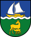
Blazon : “Divided by a silver wavy bar; above, in blue, a floating golden sailboat with a silver mast, silver sails, and golden oar; below, in green, a golden doe, turned to the left, facing backwards, suckling a standing golden fawn. "
The coat of arms was designed by the Ückeritz artists Otto Manigk and Herbert Wegehaupt and redrawn by Michael Zapfe from Weimar . It was approved on November 20, 1998 by the Ministry of the Interior and registered under the number 173 of the coat of arms of the state of Mecklenburg-Western Pomerania. |
|
| Establishment of the coat of arms: Until 1991, Ückeritz had a coat of arms with the same motif, designed in 1955 by the painter Otto Manigk and confirmed in 1960 by the Wolgast District Council, but which did not meet the heraldic requirements. In the newly drawn coat of arms, the wavy strip should symbolize the location of the place on the Baltic Sea and the Achterwasser, the sailing boat should point to the traditional fishing and the group of deer should indicate the strong red deer population in the large forests belonging to the community. |
flag
The municipality does not have an officially approved flag .
Official seal
The official seal shows the municipal coat of arms with the inscription "GEMEINDE OSTSEEBAD ÜCKERITZ * LANDKREIS VORPOMMERN-GREIFSWALD".
Attractions
→ See: List of architectural monuments in Ückeritz
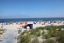
- Beach with flat shorelines and cliffs
- Camping “City” right on the beach with a shopping mile, cinema, cafes and restaurants
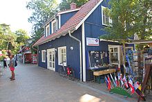
- Historic town center with fishermen's cottages on the backwater
- Uckeritz harbor with surf school
- Marina and nature campsite Stagnieß
- Forest cabinet, forest nature trail and Usedom boulder garden at the Neu Pudagla Forestry Office
- Wockninsee nature reserve (established in 1967) with nature trail. The lake silts up through peat formation; a reed area divides it in half. Bog vegetation dominates the silted areas; there are swamp violets , cranberries and sundew ; Evidence of the occurrence of the pond turtle is documented, but none has been seen since 1995. Adjacent black alder and oak forests; the oldest oak in the former Hudewald is estimated to be 400 years old with a trunk circumference of around four meters.
- Directly on the B 111, just behind the level crossing at the Neu Pudagla stop, is the oldest oak in Usedom.
Individual evidence
- ↑ Statistisches Amt MV - population status of the districts, offices and municipalities 2019 (XLS file) (official population figures in the update of the 2011 census) ( help ).
- ↑ a b c d Manfred Niemeyer: Ostvorpommern I . Collection of sources and literature on place names. Vol. 1: Usedom. (= Greifswald contributions to toponymy. Vol. 1), Ernst-Moritz-Arndt University of Greifswald, Institute for Slavic Studies, Greifswald 2001, ISBN 3-86006-149-6 . P. 35 ff
- ↑ EGH Zietlow: The Premonstratensian monastery on the island of Usedom from its foundation around 1150 until its abolition in i. J. 1535. W. Dietze, Anklam, 1858, pp. 192-193 ( digitized version ).
- ^ Gadebusch, 1863, p. 55
- ↑ Hans-Heinz Schütt: On shield and flag production office TINUS, Schwerin 2011, ISBN 978-3-9814380-0-0 , p. 373.
- ↑ a b main statute § 1 (PDF).


