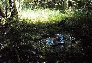
Wockninsee
| Wockninsee | ||
|---|---|---|

|
||
| Shore zone at the Wockninsee | ||
| Geographical location | District of Vorpommern-Greifswald | |
| Drain | Aalgraben to the backwaters | |
| Places on the shore | Ückeritz | |
| Data | ||
| Coordinates | 54 ° 0 '42 " N , 14 ° 3' 56" E | |
|
|
||
| Altitude above sea level | 0.2 m above sea level HN | |
| surface | 50 ha | |
| Maximum depth | 2 m | |
| Middle deep | 1 m | |
|
particularities |
silted up beach lake |
|
The Wockninsee is located east of Ückeritz in the Vorpommern-Greifswald district on the island of Usedom .
history
The largely silted-up shallow beach lake was created by a spit that separated a bay from the Baltic Sea . It is located on the northwestern edge of the tongue basin of the so-called Pudaglapforte, a humid depression that extends between Pudagla , Achterwasser and Schmollensee . The area of the lake, which used to be around 50 hectares in size, is drained into the backwaters via the eel ditch created in the 18th century. The sizes of the two remaining water areas, which are separated by reed beds , are about 6.4 and 0.8 hectares. The water depths are between 1 and 2 meters, with the original lake basin, filled with layers of mud, being up to 15 meters deep.
In a document from Duke Wartislaw IV. Of Pomerania from 1317, a jug near the Wockenynsee was mentioned, which served as a hostel for travelers who used the beach as the only continuous land route at that time. This was located in the area of the Grobe monastery and fell into disrepair in the 14th century. Bogislaw VI. In 1388 confirmed the lease agreement between the monastery and Hinrik Netzebant, who rebuilt the jug.
In the map of the Swedish land survey from 1693, the then much larger lake is shown. It bordered deciduous forest to the east, west and south . In the west and north there was a pine forest mixed with oaks and beeches. Due to the construction of the Aalbach, the lake level was lowered and wooded upland moors were created. Until 1960, cleared areas on the west side were used as grassland. Since the 1960s, sewage from an adjacent campsite has been discharged into the water.
natural reserve
On March 21, 1958, the Wockninsee was declared a nature reserve. This has a size of 49.5 hectares. The purpose is to protect the silting lake with its rocky bog covers and rocky bog areas. There is a 2.5-kilometer nature trail by the lake that begins at the Ückeritz campsite. The occurrence of the European pond turtle is worth highlighting . The very clear waters of the Wockninsees accommodates diverse algal species and is an important spawning area for amphibians such as the agile frog or newt is. Breeding birds in the area are great crested grebe , little grebe , crane and Gray Goose . The condition of the nature reserve is assessed as good, as the areas can develop largely undisturbed.
See also
literature
- Environment Ministry Mecklenburg-Western Pomerania (Ed.): Wocknin See 78 in: The nature reserves in Mecklenburg-Western Pomerania . Demmler-Verlag, Schwerin 2003, p. 188 f.
Web links
- Literature about Wockninsee in the state bibliography MV
- Map portal environment of the State Office for the Environment, Nature Conservation and Geology Mecklenburg-Western Pomerania ( information ) with geodata
- Extensive photo collection on the nature reserve
Individual evidence
- ↑ a b Official Journal of the European Communities No. L 107/4 DE1950301, data sheet ( PDF )
- ↑ Wocknin Lake. Biotope No. 04717 ( PDF )
- ↑ Wockninsee nature reserve
- ↑ EGH Zietlow: The Premonstratensian monastery on the island of Usedom from its foundation around d. Year 1150 until its abolition i. J. 1535. W. Dietze, Anklam 1858, pp. 192-193 ( digitized version ).
- ↑ a b Mecklenburg-Western Pomerania Ministry of the Environment (Ed.): The nature reserves in Mecklenburg-Western Pomerania , Demmler Verlag, Schwerin 2003, ISBN 3-910150-52-7 , p. 188


