Gnitz
Gnitz is a peninsula belonging to the island of Usedom between the bays of the Peene River Krumminer Wiek in the west and Achterwasser in the east, south of the municipality of Zinnowitz . It is identical to the municipality of Lütow .
geography
The Gnitz peninsula is located in the southwest of the island of Usedom. The north-west to Krummin and the north with the border to the municipality of Zinnowitz was formed by the "Great Strumminer See", which is now relatively silted up and is now characterized by a wooded moor area. This structure gave the Gnitz the character of an island.
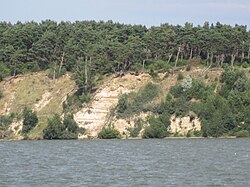
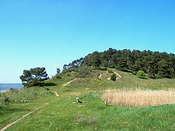
The west of the peninsula is characterized by mountain ranges and grasslands , the open dunes and beach areas, the steep bank (active cliff) with valuable woodland, the salt meadow at Möwenort, the wetlands at Rintnitz and at Geiseee and the juniper- pine forest on the White Mountain are valuable habitats that at the same time are important as retreats for various endangered and endangered animal and plant species. Möwenort on the southern slope of the White Mountain ( 32 m ) is characterized by heather vegetation, the dry grass areas, which is due to the sandy soil and grazing by sheep.
The middle (north - south) of the peninsula shows open agricultural areas with partial forest. The east is characterized by low-lying meadow areas that can only be protected from flooding by a system of dikes.
The island of Görmitz is part of the Gnitz , a flat, agricultural (livestock) island that was also used as a holiday home during the GDR era.
Today the peninsula is one of the touristically developed parts in the hinterland of Usedom, which has become increasingly interesting for tourism. Especially the nature reserve Südspitze Gnitz , the places Neuendorf and Netzelkow are important for tourism. The large natural campsite near Lütow on the White Mountain and the hotel with a spa in Lütow and other facilities made this possible.
history
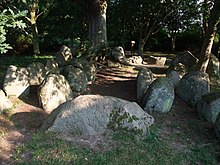
The first documented settlement took place around 4500 to 1700 BC. It originally had three, but now only the only remaining large stone grave from the Neolithic on Usedom near Lütow. This was already partially investigated in the 19th century and then completely in 1936. The numerous well-preserved finds ended up in the Provincial Museum in Szczecin. The other two large stone graves fell victim to stone hammering for the pier and road construction in the 19th century. Only a few remains are visible. At Neuendorf and on the north side of the White Mountain there are still several barrows from the following Bronze Age (1700 to 600 BCE). For the following Slav period (600 to 1200) there is hardly any archaeological evidence except for the place names (Netzelkow and Lütow). The early German settlement period (1230 to 1400) is documented by the tower hill castle near Neuendorf, which is attributed to the immigrant von Lepel family. The Gnitz, which at that time still had an island character, was until the Middle Ages, along with the monastery areas around Grobe and Pudagla and Mellenthin, one of the original settlement areas of Usedom. Many areas in the north were swampy and interspersed with lakes and therefore offered protection from attacks.
Since early German times (from 1230) the Gnitz was a fief of the von Lepel family , who worked here until 1945. Headquarters was Neuendorf, Kirchdorf and the estate was Netzelkow and on the small island Görmitz that belonged to it, a farm (dairy - cattle keeping) was set up.
Culture and sights
Architectural and ground monuments
→ See: List of architectural monuments in Lütow
- Neuendorfer manor house from the beginning of the 19th century (opened as a hotel after renovation)
- Guts distillery Neuendorf
- Neuendorf tower hill
- Weißer Berg (steep coast) - down in the water: "der rieke Steen" (the rich stone - monument for a particularly profitable fishing), a boulder with an inscription
- Large stone grave from the Neolithic near Lütow
- St. Mary's Church in Netzelkow from the 15th century with the oldest bells in Pomerania
- Netzelkow parish barn
- Lepel sarcophagus in the Netzelkower Church
Green spaces and recreation
- Nature reserve Südspitze Gnitz - named "Möwenort"
- Weißer Berg hiking area
- On November 5, 1990, the south of the peninsula was declared a nature reserve Südspitze Gnitz . The approximately 61.3 hectare area, in which many species of birds have their breeding grounds, was reduced in size with effect from September 27, 1994.
Economy and Infrastructure
Companies
- During the GDR era , oil was found on the Gnitz . At peak times, over 20 production sites were in operation, producing 220,000 tons of relatively high-quality oil per year. After 1990 there were privatizations, at present the production and marketing is carried out by a Canadian company, but the promotion is significantly limited due to the decreasing deposits. In 2018 the company produced 2,262 tons.
- The tourism industry is up and coming with the holiday resort in Lütow and the campsite on the White Mountain. There are still smaller tourist businesses in Netzelkow and Neuendorf.
- Otherwise the peninsula is characterized by agriculture and smaller industrial settlements.
traffic
With the district road K 29 and a few local roads, the peninsula has only limited transport links. The confluence in Zinnowitz and the cycle path connection from Zinnowitz to the cemetery are particularly problematic.
See also
Web links
Individual evidence
- ^ Ministry of the Environment Mecklenburg-Western Pomerania (Ed.): Südspitze Gnitz 248 in: The nature reserves in Mecklenburg-Western Pomerania . Demmler-Verlag, Schwerin 2003, p. 182 f.
Coordinates: 54 ° 2 ' N , 13 ° 53' E


