
Backwaters
| Backwaters | |
|---|---|
| Waters | Peenestrom |
| Land mass | Usedom |
| Geographical location | 54 ° 0 ′ N , 13 ° 58 ′ E |
 |
|
| width | approx. 15 km |
| depth | approx. 10 km |
The backwater ( Low German aft "rear, rear") is a lagoon of the Baltic Sea opens Peenestrom .
It protrudes so far into the island of Usedom that it is only separated from the open Baltic Sea by a narrow spit between Ückeritz and Zinnowitz . The backwater is framed in the north by the Gnitz peninsula and in the south by the Lieper Winkel . The reed-covered southeastern bulge is called Balmer See , the southwesternmost, which is difficult to access on its west side, is Krienker See.
In past centuries, there was at times direct contact with the open Baltic Sea during storm floods that spilled over the island of Usedom, when the narrowest point of the land bridge between Zempin and Koserow am Rieckgraben (near Lüttenort / museum of the painter Otto Niemeyer-Holstein ) was flooded. This land bridge between Achterwasser and the Baltic Sea is only about 300 m wide here.
The backwater is not very deep and is a popular surfing and sailing area. The beach of the backwater on the Gnitz peninsula is not as fine-grained as the Baltic Sea beach of Usedom. The bottom of the backwater is stony in many areas.
The outdated name “Lassansches Wasser” or the plural “Lassansches Wasser” can also be found on maps from the Middle Ages and early modern times. The name referred to the arable town of Lassan , which - as the only town on the backwaters - had fishing rights for these waters at that time.
gallery
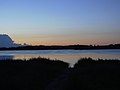
Sunrise at Lake Balmer

On the backwater in front of Loddin after rain and storm

Backwater in front of the Loddiner Höft

Resting sea eagles
on dead bank trees
in Lieper Winkel


Places and landscapes on the backwater
- Balmer lake
- Gnitz peninsula with main town Lütow and Görmitz island
- Koserow - south side
- Krienker See with the former manor Dewichow on its east bank
- Krumminer Wiek
- Lassaner Winkel with main town Lassan
- Lieper Winkel with the main town Liepe
- Loddin with Loddiner Höft
- Ückeritz - south side
- Zempin - south side
Individual evidence
- ↑ Hannelore Deya, Edwin Kuna: New historical lexicon. Haff-Verlag, 2011.