Thurbruch
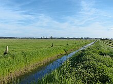
The Thurbruch is a fen area in the east of the island of Usedom . The name is derived from Thur (or Ur ), an old name for the aurochs , and therefore means aurochs swamp .
With an area of around 16 square kilometers, the Thurbruch is one of the largest fens in northern eastern Germany. In addition to the Gothensee , the largest inland lake in Usedom, there is also the Kachliner See in the Thurbruch. The area is criss-crossed by numerous drainage ditches, the oldest of which date from the 18th century.
The places Alt Bansin, Gothen , Korswandt , Ulrichshorst , Zirchow , Kutzow , Görke, Kachlin, Katschow , Labömitz and Reetzow are located directly on the Thurbruch . To the south of the area runs the federal highway 110 , on the eastern edge of which is the state road 266. To the north of the area there is still the route of the UBB , which runs between Bansin and Heringsdorf-Neuhof on a bridge over the Sack Canal . District road 41 crosses the Thurbruch between Reetzow and Ulrichshorst. Especially south of this road there are concrete slab paths for agriculture.
The observation tower on the Kückelsberg near Reetzow allows a panoramic view of the Thurbruch.
history
During the last ice age , a glacier tongue basin was created in the area of today's Thurbruch, which later became a bay of the Baltic Sea . Largely separated from the sea by a spit and dune formation, it gradually silted up. A low moor formed.
The Thurbruch was first mentioned in 1421 as silva thura (Latin aurochs forest ). The last aurochs in this area had been hunted in 1360 by Duke Wartislaw V of Pomerania . For centuries the Thurbruch was a primeval forest-like lake and swamp landscape.
Until the 18th century, the Aalbeeke (Aalbach) was the only drain. It led to the Baltic Sea. On the orders of King Friedrich II of Prussia, a drainage ditch, the Knüppelgraben , was dug from the Kachliner See to the Wolgastsee in 1750 , from where the water was directed over the Zerninsee and the peat canal at Kamminke into the Stettiner Haff . The outflow over the Aalbeeke was obstructed by water mills that were built there around 1700. After 1770 they were therefore bought up by the Prussian state and torn down. From 1772 the Bäck , the overgrown natural runoff from the Kachliner See into the Gothensee, was cleared and straightened. In the course of the land reclamation work, new settler colonies were established. That was Ulrichshorst south of Korswandt in 1774 and the place Königlich- Ahlbeck on the Aalbeeke in 1776 . The maintenance of the drains turned out to be laborious and was sometimes neglected, which silted up the Aalbeeke.
Further drainage work was carried out at the beginning of the 19th century. The President of the Province of Pomerania, Johann August Sack , who had 5000 Reichstaler available for the improvement of the area , had a trench dug from the Gothensee over the Schloonsee near Bansin to the Baltic Sea. This was named after him Sack Canal and is still the only functioning drainage of the Thurbruch. Between 1860 and 1890, the Gothensee was drained at great expense in order to gain pastureland. The costly company, which used wind and steam engine driven pumping stations, was not profitable in the long run. The water diverted from the Thurbruch via the Bäck was then carried on a dam across the Gothensee and on its east side via another ditch to the Sack Canal. The remains of the dam are still preserved.
Peat was mined in the Thurbruch over a period of 160 years until 1955 . Most recently through the "VEB Inseltorf". An average peat layer thickness of 8 meters was determined during drilling. The majority of the approximately 200,000 cubic meters served as fuel. A small proportion was used as bathing peat by the island's spa facilities.
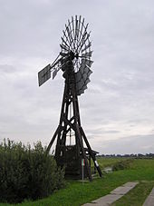
At the beginning of the 20th century, the drainage of the Thurbruch was supported by three wind-driven pumping stations , of which the Kachlin wind pumping station is still preserved as a technical monument . Since 1968 the water level has been regulated by several electrically operated pumping stations.
After the collectivization of agriculture in the GDR , mass animal husbandry in large stables was increasingly preferred to pasture husbandry in industrial animal production . In order to be able to store the green fodder obtained on the Thurbruch meadows in a space-saving and long-term manner, a feed drying plant was put into operation in Labömitz in 1970. There, the green fodder was processed into pellets with high energy input .
Despite the drainage and the intensification of agricultural use with the use of fertilizers, the ecological system of the Thurbruch remained intact for a long time. The transition to large-scale management and the complex use of amelioration measures after 1960 led to the decomposition of the peat and the subsidence of the surface by 80 to 90 cm. The biodiversity in flora and fauna decreased drastically. The former breeding area of numerous bird species is now limited to the shores of the two lakes, but still plays a role as a resting area for migratory birds.
In 1967 the Gothensee and the surrounding area of the northern Thurbruch were declared a nature reserve because of their biodiversity. However, increased nutrient input through sewage disposal led to a collapse of the lake's ecosystem in the mid-1980s. After reducing the discharge of sewage, a gradual improvement in water quality can be observed. The area south of the Gothensee was hardly affected by the increased nutrient intake. The high moor character was preserved here together with the occurrence of numerous insect species.
Web links
- Literature about Thurbruch in the state bibliography MV
- Dirk Weichbrodt: In the realm of the bog ox: The Thurbruch. In: Usedom exclusiv. 2004, archived from the original on October 29, 2007 ; Retrieved August 7, 2007 .
Coordinates: 53 ° 55 ′ 0 ″ N , 14 ° 6 ′ 37 ″ E


