Suckow (Rankwitz)
Suckow is a district of the municipality Rankwitz , approx. 3 km south of the geographical border to Lieper Winkel on the island of Usedom .
history
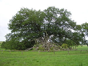
North of Suckow a large stone grave from the Neolithic (5500 to 1800 BCE) was assumed , but later investigations (1971) contradicted this and classified the complex as a burial mound from the Bronze Age (1800 to 600 BCE). It is about 8 × 8 m in size and 1 m high. It is on a hill overgrown with an old oak. The place is also called "Suckower Oak". It documents an early settlement of the area. A tower hill has been preserved near Suckow as evidence of early German settlement (from 1230). Tower hill castles were built for the locators, as the forerunners of the manors. Finds of remains of stone foundations and brick rubble show the design. At a distance of 25 m, a ring trench semicircle surrounds the facility as the rest.
Suckow was first mentioned in 1270 as "Szuinariuitz". The Slavic name is interpreted as "pig herding". In the document of March 15 of that year, the Bishop of Cammin , who owned the village, exchanged it at the request of Duke Barnim I of Pomerania-Stettin together with five other communities on Usedom ( Ückeritz , Balm am Balmer See , Loddin , Mellenthin and Krienke ) against Damerow in Western Pomerania (near Naugard ), which had belonged to the Premonstratensian monastery Grobe near Usedom (town) ; In 1309 this moved to Pudagla .
Most of the Lieper Winkel had come to the Grobe monastery two generations earlier under Barnim's grandfather Bogislaw I's widow .
In 1527 Suckow and Morgenitz came into the property of the noble von Borcke family with a manor in Krienke (there are also the spellings of Borcken and von Borck ).
Almost the entire island of Usedom was owned by the Grobe / Pudagla monastery according to the property map from 1530. Only the goods of Mellenthin and Gothen belonged to the von Neuenkirchen (Nigenkerken), Krienke and Suckow families and Regezow to the von Borcke, Stolpe den Schwerinen and the Gnitz to the von Lepel families. All other lands belonged to the church or the monasteries until 1535. After the Reformation, these possessions became dominals (state or royal property), with the exception of the lands assigned to the local churches.
In the following there are only a few regional records. The area shares the history of the island of Usedom under the Pomeranian dukes and later as part of Swedish Pomerania . The area belonged to the part of Pomerania that came to Prussia with the Treaty of Stockholm in 1720.
Suckow was a cul-de-sac village around 1880 and was dominated by rural areas.
Between 1896 and 1898 the only artificial street (cobblestone street) was built through the Lieper Winkel, which is still there today as an avenue and connects Suckow. Before that, like all other villages on the peninsula, Suckow was only accessible by land.
During the GDR era, the village expanded, but that had to do with the land reform and the creation of new farms. On July 1, 1950, Suckow was incorporated into Krienke .
At the organized tourism the place that only a few streets with some has Reet -gedeckten houses is, not make the connection found. However, interested visitors and cyclists come by during the main holiday season.
Worth seeing
- Suckow Tower Hill
Suckower oak
The at least 700 year old oak base about 1 km north of the village on the main road through the Lieper Winkel was already mentioned by Bogislaw IV of Pomerania-Stettin in 1298 in a document on the border course of the Usedom district.
The over 20 m high tree with a 30 m wide crown and a trunk circumference of 6.50 m stands on one of the large stone graves near Suckow .
Maybe she grew up outdoors; the surrounding forests had already been burned down in the time of Bogislaw I. According to other theories, it could be much older (estimated to be up to 1000 years) and in this case belong to a forest area where the Slavs - according to the name of the village - tended their pigs.
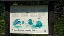
According to a local information board, three tree fungi ( Spechtloch-Schillerporling , Schwefelporling and Eichen-Feuerschwamm ) are responsible for the fact that on July 2, 1997 a strong branch broke and the trunk and branches have become so porous that the whole tree is at risk of falling over . Tourists are requested not to get closer than 10 m to the tree. Meanwhile, a second main branch has broken off and there is still a high risk of breakage.
Suckower Firs
Together with the Mellenthiner Heide and the city forest of Usedom (city) , the Suckower Tannen form a closed forest area. It is frequented by hikers and cyclists who are looking for exercise away from the holiday centers. There are no roads or restaurants (yet) in 2005; the highest point is the Kirchenberg (50 m).
Individual evidence
- ↑ Manfred Niemeyer: Ostvorpommern I . Collection of sources and literature on place names. Vol. 1: Usedom. (= Greifswald contributions to toponymy. Vol. 1), Ernst-Moritz-Arndt University of Greifswald, Institute for Slavic Studies, Greifswald 2001, ISBN 3-86006-149-6 . P. 58
Web links
Coordinates: 53 ° 55 ' N , 13 ° 58' E


