
Mölschow
| coat of arms | Germany map | |
|---|---|---|

|
Coordinates: 54 ° 5 ' N , 13 ° 50' E |
|
| Basic data | ||
| State : | Mecklenburg-Western Pomerania | |
| County : | Vorpommern-Greifswald | |
| Office : | Usedom-North | |
| Height : | 2 m above sea level NHN | |
| Area : | 15.3 km 2 | |
| Residents: | 765 (Dec. 31, 2019) | |
| Population density : | 50 inhabitants per km 2 | |
| Postal code : | 17449 | |
| Area code : | 038377 | |
| License plate : | VG, ANK, GW, PW, SBG, UEM, WLG | |
| Community key : | 13 0 75 092 | |
| Community structure: | 3 districts | |
| Office administration address: | Möwenstrasse 1 17454 Ostseebad Zinnowitz |
|
| Mayor : | Roland Meyer | |
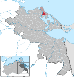
| Location of the community Mölschow in the Vorpommern-Greifswald district | ||
  |
||

Mölschow is a municipality on the northern part of the island of Usedom in Mecklenburg-Western Pomerania . It belongs to the district of Vorpommern-Greifswald and is administered by the Usedom-Nord office based in the town of Zinnowitz. Until 2005, the community was part of the office at the Peene mouth .
Geography and traffic
Mölschow lies between Zinnowitz and Wolgast between Peenestrom and the Baltic Sea coast. The federal road 111 crosses the community, which can also be reached via the Bannemin-Mölschow stop on the Züssow – Wolgast – Heringsdorf – Swinemünde railway line . The city of Wolgast is around six kilometers to the west and the Zinnowitz official seat is five kilometers east. The Wolgast-Mölschow-Trassenheide cycle path with the Karlshagen-Peenemünde junction also leads through Mölschow.
Districts
- Mölschow
- Banemin
- Drinker
- Desolations and living spaces
- Eichberg (living space)
On July 1, 2010, the parts north of federal road 111 were handed over from the municipality of Krummin to the municipality of Mölschow. 23 inhabitants were affected on approx. 19.6 hectares.
history

Banemin
Bannemin was first mentioned in a document in 1219 as "Bandemin". The current name followed in 1798. The Slavic name is not interpreted.
It is located on today's B 111 with the Wolgast – Zinnowitz section of the previous stone railway from 1882, this had a road house at the junction to Trassenheide for collecting road tolls. But that was stopped after a short time, the houses became the houses of the street guards, the so-called road masters, or the road workers. With this section of today's B 111, the gap in the Gützkow – Wolgast – Swinemünde road connection was closed.
Bannemin and Mölschow have had a train station (today a stop) on the Wolgast ferry - Zinnowitz route since 1911.
Bannemin is a street village in terms of shape and a farming village in terms of function. In addition, it had several individual settlement farms in the Feldmark, four of which were post windmills with mill farms from before 1880, of which only two existed after 1920.
On July 1, 1950, Bannemin was incorporated.
Mölschow
Mölschow was first mentioned in a document in 1182 as "Malcekowe". The Slavic name is interpreted as silent. The place name may come from the nearby lake "Molechowe". In 1278 the Pomeranian Duke Barnim I enfeoffed the German knight Voss with the goods Krummin, Zinnowitz and Mölschow. In 1282 the city of Wolgast received the land south of the Great Lake, which was formerly known as "Molcekowe". In 1302 the nunnery Wollin Mölschow took over , then in 1305 it went to the nunnery Krummin . In 1534 after the Reformation, the monastery became a royal chamber property (Dominal).
The region suffered greatly from the Thirty Years' War . After the Peace of Westphalia in 1648 Mölschow became Swedish like all of Pomerania, and after 1720 Prussian. In 1911 Mölschow received a rail connection.
On May 13, 1925, Mölschow was destroyed by a major fire. Seven years later, in addition to the domain, six farmers, a small barn and 20 houses with 148 inhabitants were mentioned in Mölschow.
Despite the dominating property, Mölschow was a street village with several branches.
The property is almost completely preserved; After many years of use as a museum object and cottage garden, it was sold in 2018.
Drinker

Zecherin is said to have been mentioned for the first time in 1267 as "Zecheryn". Like many documents relating to donations for the Grobe / Pudagla monastery, this one is also bogus. The next real mention is from the Lubin map of 1618. In between there is another mention from the secondary literature of Burkhardt and his Chronicle of Usedom from 1910, in which he mentions 1396 "Secheryn".
Zecherin is a street village on the Peenestrom, which is characterized in its function as a farming and fishing village. According to the maps, the shape and structure are preserved until after 1920; a bungalow settlement was only built along the Peene River in GDR times.
On July 1, 1950, Zecherin was incorporated.
Eichberg (living space)
Eichberg was first mentioned in 1906 in the register of places. It is the living space belonging to Mölschow at the Bannemin-Mölschow train station, built in 1906, south of Mölschow.
politics
Community representation
The local elections on May 25, 2014 led to the following result with a turnout of 58.3%:
| Party / list | Share of votes | Seats |
| CDU | 59.53% | 5 |
| Competence for Western Pomerania | 32.26% | 3 |
coat of arms
|
|
Blazon : “Split; in front a silver anchor in blue, overlaid in bars by three golden rapeseed blossoms covered in red; behind in silver half an eight-spoke blue wheel at the gap. "
The coat of arms was designed by Roland Bornschein from Wismar . It was approved on January 26, 1998 by the Ministry of the Interior and registered under the number 149 of the coat of arms of the state of Mecklenburg-Western Pomerania. |
| Justification of the coat of arms: The coat of arms symbolizes with its figures the sources of income of the inhabitants. The rapeseed blossoms are said to indicate agriculture in Mölschow, the anchor to fishing in Zecherin and the wheel to the local handicrafts in Bannemin. In terms of number, the rapeseed blossoms also represent the three districts. The shield colors document the affiliation of the municipality to the Western Pomerania region. |
flag
The municipality does not have an officially approved flag .
Official seal
The official seal shows the municipal coat of arms with the inscription "GEMEINDE MÖLSCHOW".
Attractions
→ See: List of architectural monuments in Mölschow
- Gallery Wood & Ceramics Bannemin (in the Bannemin district)
Individual evidence
- ↑ Statistisches Amt MV - population status of the districts, offices and municipalities 2019 (XLS file) (official population figures in the update of the 2011 census) ( help ).
- ↑ Area change agreement Krummin Mölschow 2010 ( Memento of the original from December 25, 2015 in the Internet Archive ) Info: The archive link was inserted automatically and has not yet been checked. Please check the original and archive link according to the instructions and then remove this notice. (PDF file; 1.39 MB)
- ^ A b c d Manfred Niemeyer: Ostvorpommern I. In: Sources and literature collection on place names. Volume 1: Usedom (= Greifswald contributions to toponymy. Volume 1), Ernst-Moritz-Arndt University of Greifswald, Institute for Slavonic Studies, Greifswald 2001, ISBN 3-86006-149-6 , p. 6.
- ↑ Mölschow estate sold. In: Ostsee-Zeitung . ( ostsee-zeitung.de ).
- ↑ Office Usedom-Nord ( Memento of the original from September 4, 2014 in the Internet Archive ) Info: The archive link was inserted automatically and has not yet been checked. Please check the original and archive link according to the instructions and then remove this notice. (PDF file; 8 kB)
- ↑ Hans-Heinz Schütt: On shield and flag production office TINUS, Schwerin 2011, ISBN 978-3-9814380-0-0 , p. 368.
- ↑ a b main statute § 1 (PDF).
Ahlbeck | Old Tellin | Altwarp | Altwigshagen | Anklam | Bandelin | Bargischow | Behrenhoff | Bentzin | Benz | Mountain wood | Blankensee | Blesewitz | Boldekow | Boock | Brietzig | Brünzow | Bugewitz | Buggenhagen | Butzow | Daberkow | Dargelin | Dargen | Dersekow | Ducherow | Eggesin | Fahrwalde | Ferdinandshof | Garz | Glazov | Görmin | Grambin | Grambov | Greifswald | Gribow | Gross Kiesow | Groß Luckow | Great Polzin | Gützkow | Hammer ad Uecker | Hanshagen | Heinrichswalde | Heringsdorf | Hinrichshagen | Hintersee | Iven | Jarmen | Jatznick | Comb teeth | Karlsburg | Karlshagen | Katzow | Kemnitz | Klein Bünzow | Koblentz | Korswandt | Koserow | Krackow | Krien | Kröslin | Kruckow | Krugsdorf | Krummin | Krusenfelde | Lassan | Leopoldshagen | Levenhagen | Liepgarten | Löcknitz | Loddin | Loissin | Loitz | Lubmin | Luebs | Luckow | Luetow | Medow | Meiersberg | Mellenthin | Mesekenhagen | Mölschow | Mönkebude | Murchin | Nadrensee | Neetzow-Liepen | New Boltenhagen | New Kosenow | Neuenkirchen | Neuenkirchen | Low | Papendorf | Pasewalk | Peenemünde | Penkun | Plow | Polzow | Postlow | Pudagla | Ramin | Rankwitz | Rollwitz | Rossin | Rossow | Rothemühl | Rothenklempenow | Rubenov | Rubkov | Sarnow | Sassen-Trantow | Sauzin | Schmatzin | Schönwalde | Spantekow | Stumble on the Peene | Stolpe on Usedom | Strasburg (Uckermark) | Torgelow | Trassenheide | Tutow | Ückeritz | Ueckermünde | Usedom | Square | Vogelsang-Warsin | Völschow | Wackerow | Weitenhagen | Wilhelmsburg | Wolgast | Wrangelsburg | Wusterhusen | Zemitz | Zempin | Zerrenthin | Ziethen | Zinnowitz | Zirchow | Züssow