
Liepgarten
| coat of arms | Germany map | |
|---|---|---|

|
Coordinates: 53 ° 43 ' N , 14 ° 1' E |
|
| Basic data | ||
| State : | Mecklenburg-Western Pomerania | |
| County : | Vorpommern-Greifswald | |
| Office : | At the Szczecin Lagoon | |
| Height : | 12 m above sea level NHN | |
| Area : | 32.81 km 2 | |
| Residents: | 766 (Dec. 31, 2019) | |
| Population density : | 23 inhabitants per km 2 | |
| Postal code : | 17375 | |
| Area code : | 039771 | |
| License plate : | VG, ANK, GW, PW, SBG, UEM, WLG | |
| Community key : | 13 0 75 078 | |
| LOCODE : | DE LPQ | |
| Office administration address: | Stettiner Strasse 1 17367 Eggesin |
|
| Website : | ||
| Mayoress : | Katja Kaps | |
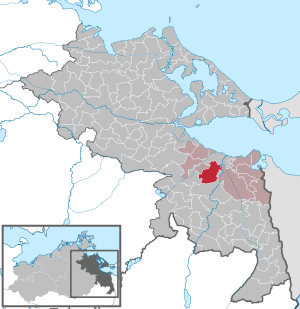
| Location of the municipality of Liepgarten in the Vorpommern-Greifswald district | ||
  |
||

Liepgarten is a municipality in the district of Vorpommern-Greifswald in the east of the German state Mecklenburg-Western Pomerania . The community is administered by the Am Stettiner Haff office based in Eggesin .
geography
The municipality of Liepgarten is directly connected to the southwest exit of the city of Ueckermünde . The municipality extends from the west bank of the lower Uecker into the Ueckermünder Heide . On the edge of the community is the Apothekerberg , at 24 m above sea level. NN the highest point between the Uecker and the Friedländer Große Wiese .
Liepgarten is surrounded by the neighboring communities of Ueckermünde in the north, Eggesin in the east, Torgelow in the south and Meiersberg in the west.
Districts
- Liepgarten
- Jädkemühl
- Star hole
history
- Liepgarten
Compared to other places in the area, Liepgarten has a much longer history. Before the Germanization in the course of the eastward expansion , there was a Slavic settlement called Lipagor (in German: Lindenberg ; first mentioned in 1241). The owners of the village changed frequently, and from 1270 it belonged to the newly founded city of Ueckermünde . From 1496 Liepgarten was again ducal property. In the turmoil of the Thirty Years War , the place was even temporarily uninhabited. Gradually, the entire area recovered and the residents opened up new branches of business in addition to agriculture.
From the beginning of the 18th century tar was burned, at the end of the 19th century many brickworks were built , in Liepgarten, which had 1,072 inhabitants in 1895, only three were in operation. In the cold season the clay was pricked, from spring it was dried and fired. A special feature was the difference in color: the bricks made to the west of the Uecker were red, those from the opposite side were yellow. Up until the Second World War, a few families lived off the barge business in Liepgarten. In 1933 the population peaked at 1,220.
Liepgarten's image has changed since the political change. In 1993 a new pavement replaced the old paving of the local road and new trees were planted. In the middle of Liepgarten is the church built in the 15th century. Some houses from the Wilhelminian era have been preserved, which still characterize the townscape today.
- Jädkemühl
Jädkemühl used to be called Gödeke Möhlen , which indicates a former mill.
- Star hole
Starkenloch emerged as one of the so-called Dutch farms , which is derived from the way of settlement (the neighboring town south of Liepgarten is called Torgelow-Holländerei ). The White Moor , which is now drained, was located between the two districts . Thanks to an environmental group, the white cotton grass that gave the area its name is now blooming again .
politics
coat of arms
|
|
Blazon : “Above a silver shield base, in it a blue wavy bar, in gold a green three-mountain, topped with a falling golden seed stand of the linden tree with five seed pods; on the Dreiberg a red linden tree with green leaves. "
The coat of arms and the flag were designed by Dieter Pahl from Liepgarten . It was approved on May 2, 2001 by the Ministry of the Interior and registered under No. 242 of the coat of arms of the state of Mecklenburg-Western Pomerania. |
| Reasons for the coat of arms: In the coat of arms, the linden tree and the three mountain are used as speaking symbols to create a visual reference to the Slavic place name (lipa góra = linden mountain). The seed stand and the tree symbolize the natural cycle at the same time. The Uecker flowing through the community hallway is to be symbolized with the wavy strip. |
flag

The flag was approved by the Ministry of the Interior on September 9, 2003.
The flag is striped in yellow, green and yellow across the longitudinal axis of the flag cloth. The yellow stripes each take up a quarter and the green central stripe half the length of the flag cloth. In the middle of the green stripe is the municipal coat of arms, which occupies two thirds of the height and one third of the length of the flag. The length of the flag is related to the height as 5: 3.
Official seal
The official seal shows the municipal coat of arms with the inscription "GEMEINDE LIEPGARTEN".
Sponsorship
Liepgarten has been sponsoring the headquarters and supply company of the 413 tank battalion, soon to be 413 hunter battalion, of the Bundeswehr in Torgelow- Spechtberg since 2002 .
Culture and sights

- Apothekerberg Liepgarten observation tower
- Erdholländer Windmill Liepgarten
- Remnants of the brickworks in Torgelower Straße - formerly 4 brickworks in Liepgarten, the clay pits can still be seen in the Feldmark
→ See: List of architectural monuments in Liepgarten
Economy and Infrastructure
Established businesses
(Selection)
|
|
|
|
Transport links
The community is located on the connecting road from Ueckermünde to Torgelow. In Ferdinandshof , 16 km from Liepgarten, there is a connection to the federal road network ( B 109 from Pasewalk to Anklam ). The next train station is in the neighboring Ueckermünde.
Personalities
- Gerhard M. Gülzow (1904–1980), until 1945 Senior Consistorial Councilor of St. Mary's Church in Danzig
Web links
Individual evidence
- ↑ Statistisches Amt MV - population status of the districts, offices and municipalities 2019 (XLS file) (official population figures in the update of the 2011 census) ( help ).
- ↑ Hans-Heinz Schütt: On shield and flag production office TINUS, Schwerin 2011, ISBN 978-3-9814380-0-0 , p. 412.
- ↑ Main Statute, Section 1, Paragraph 3 (PDF).
- ↑ Main Statute, Section 1, Paragraph 4 (PDF).
Ahlbeck | Old Tellin | Altwarp | Altwigshagen | Anklam | Bandelin | Bargischow | Behrenhoff | Bentzin | Benz | Mountain wood | Blankensee | Blesewitz | Boldekow | Boock | Brietzig | Brünzow | Bugewitz | Buggenhagen | Butzow | Daberkow | Dargelin | Dargen | Dersekow | Ducherow | Eggesin | Fahrwalde | Ferdinandshof | Garz | Glazov | Görmin | Grambin | Grambov | Greifswald | Gribow | Gross Kiesow | Groß Luckow | Great Polzin | Gützkow | Hammer ad Uecker | Hanshagen | Heinrichswalde | Heringsdorf | Hinrichshagen | Hintersee | Iven | Jarmen | Jatznick | Comb teeth | Karlsburg | Karlshagen | Katzow | Kemnitz | Klein Bünzow | Koblentz | Korswandt | Koserow | Krackow | Krien | Kröslin | Kruckow | Krugsdorf | Krummin | Krusenfelde | Lassan | Leopoldshagen | Levenhagen | Liepgarten | Löcknitz | Loddin | Loissin | Loitz | Lubmin | Luebs | Luckow | Luetow | Medow | Meiersberg | Mellenthin | Mesekenhagen | Mölschow | Mönkebude | Murchin | Nadrensee | Neetzow-Liepen | New Boltenhagen | New Kosenow | Neuenkirchen | Neuenkirchen | Low | Papendorf | Pasewalk | Peenemünde | Penkun | Plow | Polzow | Postlow | Pudagla | Ramin | Rankwitz | Rollwitz | Rossin | Rossow | Rothemühl | Rothenklempenow | Rubenov | Rubkov | Sarnow | Sassen-Trantow | Sauzin | Schmatzin | Schönwalde | Spantekow | Stumble on the Peene | Stolpe on Usedom | Strasburg (Uckermark) | Torgelow | Trassenheide | Tutow | Ückeritz | Ueckermünde | Usedom | Square | Vogelsang-Warsin | Völschow | Wackerow | Weitenhagen | Wilhelmsburg | Wolgast | Wrangelsburg | Wusterhusen | Zemitz | Zempin | Zerrenthin | Ziethen | Zinnowitz | Zirchow | Züssow