
Loissin
| coat of arms | Germany map | |
|---|---|---|
| ? |
Coordinates: 54 ° 7 ' N , 13 ° 32' E |
|
| Basic data | ||
| State : | Mecklenburg-Western Pomerania | |
| County : | Western Pomerania-Greifswald | |
| Office : | Lubmin | |
| Height : | 2 m above sea level NHN | |
| Area : | 15.3 km 2 | |
| Resident: | 797 (Dec. 31, 2020) | |
| Population density : | 52 inhabitants per km 2 | |
| Postal code : | 17509 | |
| Area code : | 038352 | |
| License plate : | VG, ANK, GW, PW, SBG, UEM, WLG | |
| Community key : | 13 0 75 081 | |
| Community structure: | 3 districts | |
| Office administration address: | Geschwister-Scholl-Weg 15 17509 Lubmin |
|
| Website : | ||
| Mayor : | Detlef Sadewasser | |
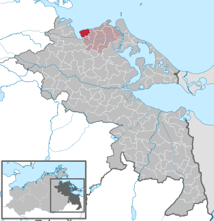
| Location of the municipality of Loissin in the Vorpommern-Greifswald district | ||
  |
||


Loissin is a municipality in the Vorpommern-Greifswald district . It is administered by the Lubmin Office based in the Lubmin seaside resort.
geography
Loissin is located between Greifswald and Lubmin on the Baltic Sea coast on the Danish Wiek and the Greifswalder Bodden . About 15 kilometers west of the municipality is the city of Greifswald and six kilometers to the east is the official seat of Lubmin.
Community structure
|
|
story
Loissin
Loissin was first mentioned in a document as Lodizin in 1248 . It was a Slavic foundation and means barge or ship .
In the document, Duke Wartislaw III confirmed . the monastery Eldena the possessions including Loissin.
Loissin was a table good for the Bishop of Cammin, but was sold in 1240 to the city of Greifswald, which exchanged it with the Eldena Monastery. After secularization , ownership of the monastery first went to the Dukes of Pomerania and was administered by the Amt Eldena. With a donation from the last Duke Bogislaw XIV , it went to the State University of Greifswald in 1634 .
In 1865 Loissin had 156 inhabitants, 12 residential buildings and 19 farm buildings.
Together with the neighboring Ludwigsburg, the Greifswald merchant Weißenborn also acquired Loissin in 1810. The Loissin Manor was built in the second half of the 19th century. After 1945 it was a residential building, kindergarten and community nurse's station. In the GDR era, Loissin was the seat of the agricultural production cooperative (LPG) Helles Ufer and is still more agricultural today in the core town. To the north of the core town, an extensive leisure facility was built directly on the Bodden coast during the GDR era. This included a bungalow settlement and a large campsite. After 1990 a lot was modernized and expanded, and infrastructures were added that were necessary for tourism. Loissin became an important tourist center in the area, together with its core town.
Gahlkow
Gahlkow was first mentioned in a document as Golkogh in 1248 and only mentioned in today's spelling in 1648. The Slavic place name means something like bare or naked .
Gahlkow was transferred to the Eldena Monastery in 1299 under the name "Golcow" by Duke Bogislaw IV . In 1305 it was placed in the newly founded parish of Loissin. When and to what extent the village was transferred from the monastery to private ownership is unclear. In 1462 the von Lübeck family was wealthy here.
Gahlkow was a manor, owned by the von Lühmann family before 1809, and then by the von Vahl family.

Gahlkow had 96 inhabitants in 1865 and of buildings - 9 residential houses, 1 factory (windmill) and 10 farm buildings.
A controversial medieval relic was discovered on Gahlkow Beach. It is a large boulder with a sea-side Viking Age engraving of a longboat. Controversial because it is hardly possible to scientifically date such scratched drawings; they can either be original or modeled on them. The drawing can only be seen when the tide is south-westerly - offshore wind. There are some similar drawings from the period mentioned, especially in Scandinavia, but doubts remain.
Ludwigsburg
The finds from the Neolithic after several excavations in the location and in the surrounding area indicate settlement since the Neolithic Age (4500 to 1700 BC). A Bronze Age burial ground (1700 to 600 BC) northeast of Ludwigsburg shows the settlement by the Germanic peoples.
Ludwigsburg was first mentioned in a document as Darsinus in 1184 and as Darsim in 1207 in the general approval for the Eldena Monastery, to which the village belonged from the beginning. It is a Slavic foundation, as the surrounding archaeological settlements show and means something like "the wild forest" or "protruding land". A document from 1281 with the confirmation of Duke Bogislaw IV named the place as "grangiam Dersim cum slavicali villa eodem nomine nuncupata", ie as a completely Wendish village. That this Darsim, mentioned in a document, was located directly in the locality as a forerunner of Ludwigsburg, is as good as proven. A tax register from 1581 names the place Dersem with eight farmers and one Kruger on 20 Hufen under the Amt Eldena. The field name "Darsimhövet" at Ludwigsburger Haken, the Lanken , was a reminder of the old place name until the 19th century.

Darsim belonged to the Eldena Monastery until 1534 , with the secularization the village came to the Dukes of Pomerania. In 1586, Duke Ernst Ludwig donated the village of Dersim and the whole of Dersim to his wife Sophia Hedwig from the House of Braunschweig-Lüneburg. A farm (estate) with a building yard and the princely house were built. The place was initially called Ludwigshof , which later became Ludwigsburg . The Duchess, meanwhile a widow, left the estate with the castle to her creditors in 1609, but retained the property rights.
As a result of the Thirty Years' War , Ludwigsburg and Pomerania came under Swedish rule in 1631, which lasted until 1815. After the death of Duchess Sophia Hedwig, the Ludwigsburg estate came to the Duchess Anna von Croy and her son in 1631, but in 1650 she sold it to the Swedish General Burchard Müller von der Lühnen. In 1747 it was auctioned to the von Horn family and again in 1776 - then to the von Klinkowström family. In 1810 it was bought by the Greifswald merchant Weißenborn, whose family owned the estate until 1945.
In 1865 Ludwigsburg had 175 inhabitants and had a church, a school, twelve residential buildings (with a castle), two factory buildings and 20 farm buildings. In 1937 Ludwigsburg was incorporated into the municipality of Wusterhusen and has been a district of Loissin since July 1, 1950.
After the Weissenborn family fled to West Germany in 1945, the estate was partially relocated as part of the land reform . The castle was used as living space for refugees until it was vacated in 1975 and then used by the agricultural production cooperative founded in 1953 . Although the castle had been placed under a preservation order, it was left to decay. Sponge infestation, moisture penetration, woodworm infestation and other damage were the result. Jörg Weissenborn, a descendant of the family, bought back the castle, manor and park in 1993. An agreement on use and maintenance was concluded with the newly founded castle association, which also includes two members of the Weissenborn family. The association had set itself the goal of saving the last surviving Pomeranian ducal castle on German soil and putting it into meaningful use. With the help of monument preservation, the sponge renovation, the roof renewal and other security measures were carried out despite financial problems and thus the decay was halted.
Beliz (desert)
The place was mentioned in a document by the name in 1248. It was then no longer described, so it fell desolate. It is assumed that the place burned down and rose again as Loissin. This is also confirmed by the archaeological findings in the Slavic settlement around 400 meters south of Loissin.
Budim (desert)
Budim was mentioned in a document with the name Budimae in 1209. The name is interpreted with the term awaken . The position of the place cannot be determined exactly. It is only known that the place is said to be not far from today's Ludwigsburg, the then Darsim. Several Late Wendish (1000–1200) settlements have been archaeologically proven north of Ludwigsburg. Budim was one of them. The documentary mentions last until 1250, then the place probably became desolate.
Merotiz (desert)
North of Ludwigsburg lies a deserted area called Merotiz , it was mentioned in a document as early as 1209, but then soon disappeared. The location was controversial for a long time until ground monument curator W. Hornemann made clear discoveries in 1967 and was thus able to locate the desert.
politics
Coat of arms, flag, official seal
The municipality has no officially approved national emblem, neither a coat of arms nor a flag . The small state seal with the coat of arms of the region of Western Pomerania is used as an official seal . It shows an upright griffin with a raised tail and the inscription "GEMEINDE LOISSIN".
sightseeing features
→ See: List of architectural monuments in Loissin
- Ludwigsburg Palace , manor and park
- Ludwigsburg Chapel and Ludwigsburg Mausoleum
- Historic brick half-timbered cottages from the 19th century in Ludwigsburg
- Lanken nature reserve in the eastern part of the district
- Area natural monument "Großer Holz" south of the cottage settlement
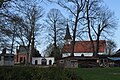
- Loissin fisherman's house
- Bildstein on the beach of Gahlkow - Viking ship - only visible from the sea side at low tide

Ludwigsburg park and courtyard
Ludwigsburg - church, portal and mausoleum

Gut Ludwigsburg inside gate entrance with coat of arms

Kitesurfing on the lagoon coast near Loissin


literature
- Heinrich Berghaus : Land book of the Duchy of Pomerania and the Principality of Rügen, Part IV, Volume II, Anklam 1868, pp. 1100 ff. And 398 ff.
- Manfred Niemeyer: East Western Pomerania. Collection of sources and literature on place names. Vol. 2: Mainland. (= Greifswald contributions to toponymy. Vol. 2), Ernst-Moritz-Arndt University of Greifswald, Institute for Slavic Studies, Greifswald 2001, ISBN 3-86006-149-6 .
Web links
- Loissin on the website of the Lubmin Office
Individual evidence
- ↑ Statistisches Amt MV - Population status of the districts, offices and municipalities 2020 (XLS file) (official population figures in an update of the 2011 census) ( help on this ).
- ↑ a b c d e f Manfred Niemeyer: Ostvorpommern . Collection of sources and literature on place names. Vol. 2: Mainland. (= Greifswald contributions to toponymy. Vol. 2), Ernst-Moritz-Arndt University of Greifswald, Institute for Slavic Studies, Greifswald 2001, ISBN 3-86006-149-6 . P. 17 ff
- ↑ Pommersches Urkundenbuch , Vol. I, No. 478.
- ↑ Pommersches Urkundenbuch , Vol. III, No. 1917.
- ↑ Pomeranian Document Book , Vol. IV, No. 2219.
- ↑ H. Hoogeweg, Monasteries in Pomerania, Part 1, Stettin, 1924, p. 539
- ↑ H. Hoogeweg, Monasteries in Pomerania, Part 1, Stettin, 1924, p. 535
- ↑ Dirk Schleinert , On the early history of the castle and estate Ludwigsburg near Greifswald , In: Pommern. Zeitschrift für Kultur und Geschichte, 38 vol. (2000), no. 3, pp. 14-16.
- ↑ Genealogical index of places
- ↑ Main Statute § 1 (PDF).
Ahlbeck | Old Tellin | Altwarp | Altwigshagen | Anklam | Bandelin | Bargischow | Behrenhoff | Bentzin | Benz | Mountain wood | Blankensee | Blesewitz | Boldekow | Boock | Brietzig | Brünzow | Bugewitz | Buggenhagen | Butzow | Daberkow | Dargelin | Dargen | Dersekow | Ducherow | Eggesin | Fahrwalde | Ferdinandshof | Garz | Glazov | Görmin | Grambin | Grambov | Greifswald | Gribow | Gross Kiesow | Groß Luckow | Great Polzin | Gützkow | Hammer ad Uecker | Hanshagen | Heinrichswalde | Heringsdorf | Hinrichshagen | Hintersee | Iven | Jarmen | Jatznick | Comb teeth | Karlsburg | Karlshagen | Katzow | Kemnitz | Klein Bünzow | Koblentz | Korswandt | Koserow | Krackow | Krien | Kröslin | Kruckow | Krugsdorf | Crooked | Krusenfelde | Lassan | Leopoldshagen | Levenhagen | Liepgarten | Löcknitz | Loddin | Loissin | Loitz | Lubmin | Luebs | Luckow | Luetow | Medow | Meiersberg | Mellenthin | Mesekenhagen | Mölschow | Mönkebude | Murchin | Nadrensee | Neetzow-Liepen | New Boltenhagen | New Kosenow | Neuenkirchen | Neuenkirchen | Low | Papendorf | Pasewalk | Peenemünde | Penkun | Plow | Polzow | Postlow | Pudagla | Ramin | Rankwitz | Rollwitz | Rossin | Rossow | Rothemühl | Rothenklempenow | Rubenov | Rubkov | Sarnow | Sassen-Trantow | Sauzin | Schmatzin | Schönwalde | Spantekow | Stumble on the Peene | Stolpe on Usedom | Strasburg (Uckermark) | Torgelow | Trassenheide | Tutow | Ückeritz | Ueckermünde | Usedom | Square | Vogelsang-Warsin | Völschow | Wackerow | Weitenhagen | Wilhelmsburg | Wolgast | Wrangelsburg | Wusterhusen | Zemitz | Zempin | Zerrenthin | Ziethen | Zinnowitz | Zirchow | Züssow