
Gützkow
| coat of arms | Germany map | |
|---|---|---|

|
Coordinates: 53 ° 56 ' N , 13 ° 25' E |
|
| Basic data | ||
| State : | Mecklenburg-Western Pomerania | |
| County : | Vorpommern-Greifswald | |
| Office : | Züssow | |
| Height : | 16 m above sea level NHN | |
| Area : | 57.29 km 2 | |
| Residents: | 2978 (Dec. 31, 2019) | |
| Population density : | 52 inhabitants per km 2 | |
| Postal code : | 17506 | |
| Area code : | 038353 | |
| License plate : | VG, ANK, GW, PW, SBG, UEM, WLG | |
| Community key : | 13 0 75 044 | |
| LOCODE : | DE GOW | |
| City structure: | 12 districts | |
| Office administration address: | Dorfstrasse 6 17495 Züssow |
|
| Website : | ||
| Mayoress : | Jutta Dinse | |
| Location of the city of Gützkow in the Vorpommern-Greifswald district | ||
  |
||

Gützkow is a country town in the Vorpommern-Greifswald district in Mecklenburg-Vorpommern . It belongs to the Züssow office and forms a basic center for its surroundings .
geography
Geographical location
Gützkow is located 20 km south of the district town of Greifswald and 28 km west of Wolgast and northwest of Anklam . The city is bordered to the south by the Peene . The Swinow flows through the urban area and flows into the Peene south of Gützkow. The Swinow has been rehabilitated in its course since 2011, starting at the lower course (canal), flood plains were created that also serve as wetlands . The course was partly led back into the natural meander . The Kosenowsee is located in the eastern part of the urban area .
City structure
According to its main statute, the following districts belong to the city of Gützkow:
|
||
Neighboring communities
Neighboring communities are Behrenhoff in the north, Groß Kiesow in the northeast, Züssow and Schmatzin in the east, Groß Polzin in the southeast, Neetzow-Liepen in the south, Jarmen in the southwest, Bentzin in the west and Bandelin in the northwest.
geology
Gützkow and the surrounding villages are located on a raised area of land that rises approx. 16 meters above sea level . This slab, which consists of loam underground, is severely cut up around Gützkow by glacial channels of the Swinow, the Dargeziner Bach and other smaller brooks. These channels with the still existing flowing waters and the boggy marginal areas give the landscape around Gützkow a special charm. Towards the Peene, the plate drops off relatively steeply and almost forms a cliff . At the mouths of the Ice Age gullies in the glacial valley of the Peene, compact sand and gravel deposits can be found almost everywhere. Often there are also clay pits, especially near the Peene, that were used by the goods for the production of bricks. North of the village one takes place in Bandelin Os in an east-west orientation towards, which also serves the sand and gravel extraction. A salt belt stretches from Bad Sülze in the west to Gützkow and ends at Kölzin. To the east of Gützkow, the pharmacist Ascher discovered a limestone deposit on the high bank of the Swinow around 1900, but it was never exploited.
History of the city


Surname
The name Gützkow comes from Slavonic. The name is derived from the Slavic Gost = guest and therefore means the place of the guests , referring to the documented temple to which the residents came from the area for cult acts. According to Heinrich Berghaus, this also applies to the spelling with "C". Gützkow was named in the documents of 1128 Gozgaugia , 1163 Gozcowa , 1175 Gotzchowe , 1207 Gotzkowe and 1228 Gutzecowe among many other similar spellings, from 1249 only spellings with "G" were used. The spelling with "C" took place in 1140 when the place was identified with Chozcho , 1183 as Chozkowe , 1214 as Chozcowe and 1228 as Gutzkowe . The Low German name is Gütschow .
City fortifications
The city had two city gates, the Mühlentor or also called the gate to the mills and the Hohe Tor or also the Kuh-Tor , both of which were demolished during road construction around 1850. Gützkow never had a city wall, the natural steep slopes were only protected with so-called hookwork . This hookwork is clearly recognizable in the Stralsund illuminated manuscript from 1611/15. Behind today's town hall was an archaeologically proven defense tower with a view of the Peene. An extensive system of ramparts and ditches was laid out in front of the steep slopes leading to the Stadtberg. They are clearly recognizable in the city map from the Swedish military atlas. These fortifications were leveled around 1790 as there were no more building sites for houses in the city. The so-called town wall in the village is a hillside retaining wall made of field stones that was built in several parts around 1890. It was partially z. B. restored in the Seilergang and in the pastor park. The reconstructions on the town hall stairs and on the cantor hill for the slope reinforcement were extensive, the L-concrete elements were up to 4 m high and were gradually raised and then clad with field stone walls.
Early history and the Middle Ages
Because of its favorable geographical location, Gützkow has been populated since the Neolithic , as proven by archaeological finds . Many finds also prove the settlement of Teutons . After the Great Migration , the place with the hilltop castle was the seat of Slavic princes. In 1128 Gützkow was mentioned in connection with the missionary Bishop Otto von Bamberg , who had the famous Slavic temple destroyed. From 1164 to 1177 (destroyed by Henry the Lion or King Waldemar I of Denmark) the place was named by the Danish chronicler Saxo Grammaticus and in the Knýtlinga saga . Around 1175 the settlement was called Burgward . Around 1230 it was converted into a German city. A branched network of roads was created on the natural hill at the Swinowbach valley.
Since the 12th century Gützkow belonged to the domain of the Pomeranian dukes, who settled it with German immigrants mainly from the 13th century. In the 13th and 14th centuries it was the Counts of Gützkow who ruled the region as feudal people and relatives of the Pomeranian dukes. Since 1300/1301 and 1353 as a civitas with Lübsch city rights , Gützkow was mentioned in a document, but the city's foundation is assumed in 1235. The parish church of St. Nikolai was built from 1241.
1600-1900
As a result of the Thirty Years' War , in 1648 the Pomeranian areas to the west and in a strip east of the Oder with Stettin and thus also Gützkow came under Swedish rule. In 1720, as a result of the Great Northern War , Gützkow became a Swedish border town to Prussia with a border and customs station on the Gützkower ferry. Swedish Western Pomerania now consisted only of the area north of the Peene without Usedom and the island of Rügen. In 1729 the city burned down almost completely, including the church. The fire had started from the parish farm and spread quickly due to a strong easterly wind, only the Schulzenhof / Torney district remained. The Swedish provincial government in Stralsund then decreed that no buildings with straw or reed roofing were allowed to be built in the city, therefore the barns outside the city - according to the map in 1761 to the north and east. After the Congress of Vienna in 1815, Swedish Western Pomerania came to Prussia with Gützkow.

In the 19th century there was an economic boom, especially in handicrafts and trade. The population increased from 997 inhabitants in 1816 to 1992 in 1864. In the second half of the 19th century, the city council hindered the further development of the city by various resolutions. The Angermünde-Stralsund Railway , built in 1863, refused to touch the place . The same was done with regard to the Greifswald-Jarmener-Kleinbahn (GJK) , so that in 1897 the railway line could only be led via Gut Wieck to Jarmen. The construction of a sugar factory was also refused, so it was built in Jarmen. In 1907 the Gützkow starch factory was established as shareholders at the instigation of the influential landowners . A branch line from Wieck was built for this factory in 1907, and in 1908 it was extended to the Gützkower ferry . In 1926, the section from the ferry to the starch factory was dismantled due to insufficient utilization. When Wieck was incorporated into Gützkow with other places in 1928, the city had a train station on its territory.
Modern times

The small railway line was shut down in 1945 and the track systems and the vehicle fleet were dismantled and transported to the Soviet Union as reparations . The starch factory and Frank Wagenbau were expropriated and initially continued as state-owned companies. The LBH factory was established at Frank, which in 1952 became VEB Landmaschinenbau Gützkow, which relocated its production to the former starch factory. In 1966, this became part of the Neubrandenburg Repair Plant (RWN), where repairs and spare parts production for tanks and armored vehicles of the NVA and the Warsaw Pact armies were carried out. After the reunification , the RWN Gützkow with 400 employees was dissolved.
In order to improve the housing situation in the city, a workers' housing cooperative (AWG) was founded in March 1959 and the first twelve apartments in Friedrich-Ludwig-Jahn-Straße were completed in 1962. In 2002 the cooperative owned 140 apartments in Gützkow.
After 1990, other structure-determining businesses, such as LPG (plant production) with 350 and LPG (animal production) with 150 employees, were wound up . The NVA base built in 1968, a radio and radar detection unit with around 20 soldiers, was closed by the Bundeswehr . This is where the district's fire service center was built.
From 1991 the historic city center with the town hall was completely renovated as part of urban development funding.
From 1952 to 1994 Gützkow belonged to the Greifswald district (until 1990 in the GDR district of Rostock , 1990–1994 in the state of Mecklenburg-Western Pomerania ). In 1994 the city was incorporated into the Ostvorpommern district. Since the district reform in 2011 , it has been in the Vorpommern-Greifswald district .
Gützkow was the seat of the Gützkow office from 1992 and has been part of the Züssow office since 2005 .
History of the districts
Breechen was first mentioned as Briechem in a document in 1574 and was often referred to as Breichen after 1629 . The community of Breechen-Neuendorf has belonged to Gützkow since June 13, 2004.
Dargezin was first mentioned in 1232 as Targossin and was only called Dargatczin in 1491 .
Dargezin-Vorwerk was first mentioned in 1774 and joined Kölzin in 1962 and Gützkow in 2014.
Fritzow is a Slavic foundation and was first mentioned in 1353 as Vritzou (Slavic for heather) and from 1597 as Fritzow . She has a manor from around 1890.
Gützkow Meierei was established as the Vorwerk of the Wieck estate after 1835.
Kölzin was mentioned in a document in 1451 as Koltzyn . The church was consecrated in 1862. On May 25, 2014, the community of Kölzin with its districts of Kölzin, Upatel, Fritzow, Dargezin and Dargezin-Vorwerk was incorporated into Gützkow.
Lüssow was first mentioned in 1228 as Lutzowe (Slavic for grim people ) and in 1597 as Lüssow . The place has a late Gothic church from the 15th century and a manor house from 1867. With effect from January 1, 2010, the community of Lüssow was incorporated into Gützkow.
Neuendorf was mentioned in a document as Nygendorpe in 1446 . It is an early German foundation.
Owstin was first mentioned in a document as Owstyn (Slavic for sheepfold) in 1327 . Here is a manor house from around 1700. Owstin was incorporated on August 24, 1961. Owstin belonged to the Lüssow estate until 1928 and therefore only came to Gützkow in 1961.
Pentin was first mentioned in documents as Pentyn in 1334 . The manor house dates from around 1850. The place was incorporated in 1928.
Upatel was first mentioned in 1315 as Upatel and again in 1353 as Upatell . The place was incorporated into Kölzin in 1950 and Gützkow in 2014.
Living spaces
Schulzenhof / Torney has belonged to Gützkow since 1913.
Wieck (Slavic Vik for market) is an early town in the Feldmark and has many archaeological sites. The estate was owned u. a. der Gützkow (around 1372), Neuenkirchen (from 1447), Eickstedt (from 1628) and Lepel (from 1664). The mansion was built in 1797. With Wieck in 1928 the dairy (Vorwerk von Wieck) and Vargatz were incorporated. Vargatz belonged to the municipality until 1949 and then came to Bandelin by referendum .
Historic districts
Crowelin was mentioned in a document in 1334 and later in 1356. The Slavic name is interpreted as cow . It is said to have been a Meierhof, which had the tower hill castle "Stüer Gützkow", which is still preserved as a relic today, as a mansion. There the Gützkower Count Lippold von Behr was named as Vogt. The agriculture belonging to the Gützkower Church is still called the Krowelin today. It lies north of the city and extends to Fritzow.
Swynrow was first mentioned in 1321 and then in 1353. The name means swineherd in Slavonic . According to the documentary evidence, the no longer existing place could be located. The place was later referred to in real estate maps with the field name Dbodstell . Archaeological surface surveys were carried out from 2000 to 2003, and also later with searches. Over 1500 finds, mainly Slavic ceramics from early to late Wendish, have been secured. Even later, many hundreds of finds were made after further searches, including many metal scraps and slag, which indicates extensive metal processing. On the slope of the Swinowbach there are also larger lawn iron stone camps that were safely used for this. The last spectacular find on the Dbodstell was the fragment of the seal of Count Johannes I. von Gützkow from around 1250. This fragment of the seal is next to that of Rügenfürst Witzlaw III. one of the few high nobility in early medieval Germany.
Population development
Information from the State Statistical Office of Mecklenburg-Western Pomerania
|
|
Status: December 31 of the respective year
The increase in the number of inhabitants in 2015 is due to the incorporation of Kölzin in 2014.
Information from the literature and the registration office
| year | Gützkow | Wieck | ferry | Schulzenhof | Owstin | Pentin | Houses-Gützkow | Commercial establishments | comment |
|---|---|---|---|---|---|---|---|---|---|
| 1687 | 104 | - | - | - | - | - | - | - | after war and plague |
| 1764 | 558 | - | - | - | - | - | 126 | 79 | |
| 1800 | 825 | - | - | - | - | - | - | - | |
| 1816 | 997 | - | - | - | - | - | 171 | 97 | |
| 1864 | 1992 | 137 | 4th | 15th | 83 | 118 | 261 | 174 | |
| 1905 | 2096 | 135 | 18th | 12 | 55 | 113 | - | - | 1913 and 1928 incorporated |
| 1925 | 1982 | - | - | - | - | - | - | - | |
| 1939 | 2900 | - | - | - | - | - | - | - | |
| 1946 | 4600 | - | - | - | - | - | 419 | - | Refugees and displaced persons |
| 1956 | - | - | - | - | - | - | - | 105 | 984 employees |
| 1975 | 3500 | - | - | - | - | - | 492 | - | |
| 1983 | 3800 | - | - | - | - | - | - | - | |
| 1990 | 2932 | - | - | - | - | - | - | - | |
| 1998 | 2886 | - | - | - | - | - | 546 | - | |
| 2008 | 2893 | - | - | - | - | - | - | - |
Gützkow (city) with Wieck, Schulzenhof and Fähre had 2216 inhabitants with main residence and 97 with secondary residence on December 31, 2014.
| year | Breeches | Dairy farm | Neuendorf | Owstin | Pentin | Gützkow | Lüssow | Community of Gützkow * | Dargezin | D. Vorwerk | Fritzow | Upatel | Kölzin | Kölzin community | |
|---|---|---|---|---|---|---|---|---|---|---|---|---|---|---|---|
| 2005 | 121 | 58 | 106 | 71 | 70 | 2376 | 194 | 2802 | 165 | 35 | 45 | 56 | 72 | 375 | |
| 2006 | 122 | 55 | 100 | 70 | 68 | 2348 | 186 | 2763 | 170 | 35 | 40 | 50 | 67 | 362 | |
| 2007 | 120 | 54 | 107 | 68 | 64 | 2312 | 182 | 2727 | 157 | 32 | 46 | 44 | 66 | 345 | |
| 2008 | 121 | 49 | 106 | 70 | 67 | 2291 | 184 | 2704 | 149 | 30th | 46 | 46 | 61 | 332 | |
| 2009 | 124 | 48 | 97 | 72 | 70 | 2249 | 182 | 2660 | 145 | 29 | 43 | 44 | 54 | 315 | |
| 2010 | 121 | 48 | 98 | 72 | 69 | 2247 | 183 | 2838 | 140 | 29 | 43 | 47 | 56 | 315 | |
| 2011 | 123 | 48 | 96 | 68 | 63 | 2258 | 175 | 2831 | 138 | 31 | 39 | 46 | 48 | 302 | |
| 2012 | 118 | 50 | 98 | 67 | 61 | 2229 | 171 | 2794 | 144 | 30th | 41 | 46 | 52 | 313 | |
| 2013 | 120 | 50 | 92 | 73 | 58 | 2233 | 173 | 2799 | 140 | 32 | 37 | 49 | 52 | 310 | |
| 2014 | 130 | 53 | 93 | 78 | 60 | 2313 | 188 | 3243 | 152 | 35 | 38 | 50 | 53 | - | |
| 2015 | 130 | 56 | 91 | 78 | 62 | 2326 | 178 | 3247 | 146 | 36 | 39 | 54 | 51 | - |
* Until 2009 without Lüssow, from 2010 with Lüssow, from 2014 with the former municipality of Gützkow
Note: The localities of the former municipality of Kölzin came to the municipality of Gützkow on May 25, 2014 and will only be part of the population from 2014.
The statistics for 2014 and 2015 include the number of residents with secondary residences as they are legally included in the official statistics.
politics
City council
The elections for the Gützkow city council on May 26, 2019 led to the following result:
| Party / list | Share of votes | Seats |
| Citizens' Alliance Gützkow | 33.3% | 5 |
| CDU | 31.4% | 4th |
| Free voters | 15.2% | 2 |
| Kölzin community of voters | 10.2% | 1 |
| AfD | 5.3% | 1 |
| The left | 4.7% | 1 |
mayor
- 2005-2014: Joachim Otto (CDU)
- since 2014: Jutta Dinse (independent, for the CDU)
In the mayoral election on May 26, 2019, Dinse was confirmed in office with 51.7% of the valid votes for a further five years (voter turnout 51.3%).
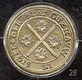
coat of arms

|
|
Blazon : "In gold, two diagonally crossed red sticks , angled by four red roses withgolden inscriptionsand green sepals."
The coat of arms was redrawn in 1999 by the Schwerin heraldist Heinz Kippnick and registered under the number 178 of the coat of arms of the state of Mecklenburg-Western Pomerania. |
|
Reasons for the coat of arms: The coat of arms of the city of Gützkow first becomes tangible in 1300/1301 in a seal of the city, which is located on a document in the Rostock city archive . It goes back to the seal and coat of arms of the noble lords of Salzwedel, who came from the Altmark, and of the later Counts of Gützkow. One of Jaczo I's sons not only granted the city its town charter, but also its coat of arms, which was also incorporated into the large nine-field coat of arms of the Duchy of Pomerania .
Except in various seals, the oldest of which are from the 17th and 18th centuries and where the coat of arms is usually shown without a crown, but occasionally also with a count's crown , the city coat of arms was never shown figuratively. Only from the year 1881 is a pictorial representation from the registry of the coat of arms of the province of Pomerania handed down. This shows a three-armed wall crown for cities with less than 100,000 inhabitants. In 1871 the coat of arms with the count's crown was attached to the center of the newly built Gützkower town hall. The same happened in 1879 on the Hasenberg at the Schützenhaus. |
flag

The city does not have an officially approved flag .
Gützkow seems to have an unofficial flag. It is a red and yellow striped flag with the city coat of arms placed in the middle, which is crowned with a city wall. If this is the case, the city is violating local law, as national emblems - and this also includes flags - must be legally legitimized, i.e. approved or confirmed, by official bodies.
Official seal
The official seal shows the city arms with the inscription STADT GÜTZKOW . The seals have been handed down in various designs since around 1600, they are now in the city museum. City treasury and police, and later also the registry office, had their own seals, which in the first two institutions were similar to the city seals; the registry office seal was adapted to the Prussian seal.
Note: The numbers on the bottom right of the seals are the diameter in mm, the mounts are mirrored.

Seal of Gützkow 1300/1301
Seal of the city of Gützkow around 1600

Seal of the city of Gützkow around 1700
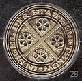
Seal of the city of Gützkow around 1800

Seal of the city of Gützkow around 1900


Twin cities
- Bohmte (Lower Saxony), municipality in the district of Osnabrück , since June 29, 1991
- Nowogard (Poland), town in the powiat Goleniowski in the West Pomeranian Voivodeship , since August 24, 2000
Sights and culture

Buildings
- Nikolaikirche , first mentioned in 1241, making it one of the oldest buildings in Pomerania. The brick-built early Gothic stone building with the three-bay nave and the brick gable and window walls were renovated after the city fire of 1729 and extensively rebuilt from 1881 to 1883. The west tower dates from the 14th or 15th century.
- Town hall from 1871, brick building with plaster ashlar, base made of field stone
- Half-timbered houses from the 18th century, u. a. Parsonage from 1730 (Kirchstrasse 11), Ackerbürgerhaus (Kirchstrasse 3), deacon house (Kirchstrasse 12) and smithy (Kirchstrasse 7)
- Schlossberg , seat of the Slavic princes, the Gützkow counts (1216–1359 / 1378) and Duke Barnim VII (1425–1451), an important European ground monument , exposed from 1930 to 1934 until around 1200
- Memorial for the 800th anniversary of Christianization on the east side of Nikolai Church from 1928, consisting of the stones from the Klünterstein von Dambeck grave
- "Stuer" tower hill
- Church of St. Marien in Kölzin (neo-Gothic) from 1862, branch church of Gützkow
- The chapel in Kuntzow, first mentioned in 1425, belongs to the Gützkower parish, in the chapel and in the cemetery older burials of the von Corswandt family
- Lüssow church from 1823 and 1878 with older remains
- Manor house (castle) in Lüssow from 1869
- Neuendorf manor house from the 19th century
- Manor house (manor house) in Owstin from the 19th century
- Manor house in Pentin from around 1850
- Wieck Castle , former mansion of the von Lepel family from 1797, school from 1932, clubhouse from 1972 and castle high school since 1991
- Wieck grave chapel , built in 1859, reconstructed from 1996 to 2003, now set up as a wedding chapel
Memorials
- Memorial to those who fell in the wars of 1866/1871 on the church square (from 1890)
- Memorial for the 106 fallen from World War I from Gützkow, expanded in 2003 to include the 269 fallen and missing from World War II, built in 1921 on the Hasenberg
- War cemetery for two slave laborers and a German sergeant in the cemetery, established in 1944/45
Green spaces and recreation
- Nature reserve Peenewiesen on both sides of the ferry dam with the Totenberg viewpoint
- Parks in Wieck and Lüssow
- Kosenowsee with bathing establishment, promenade path and open-air stage
- "Hasenberg" and "Schiefenberg" parks
- Canoe station on the canal
- Boathouse facilities near Gützkow, Lüssow and Breechen
Economy and Infrastructure
Gützkow is characterized by agriculture. The Gützkow LPG (plant production), which was dominant in the GDR, became Wiecker Pflanzenbau GmbH, but had to be reduced from the original 8,000 hectares to around 6,000 hectares. The former LPG (animal production) Gützkow was also reduced, has its seat in Dargezin and still remnants and areas in some places (e.g. Upatel). There are also other, but small, private farmers.
Businesses are located in almost all districts. The largest are the forwarding and building trade in Görs, the Fischer beverage trade, the Hecker joinery and many craft businesses. The retail establishments are concentrated in Gützkow, the largest being Lidl and Netto . A number of service facilities, restaurants and service providers are also concentrated here.
traffic
The federal road 111 leads through the city to Wolgast - since 2005 with a northern bypass. Two km to the west is the Gützkow junction on the federal autobahn 20 ( Rostock - Uckermark junction ).
Gützkow has no rail connection. The closest train station is Züssow on the Berlin – Stralsund line .
education
Gützkow has a regional school with a primary school, the "Peenetal School", and the "Schlossgymnasium Gützkow". There is also a daycare center in town.
Personalities
sons and daughters of the town
- Eleonore Hyppolithe Rühs (1774–1845), daughter of Johann August Kriebel and wife of the historian Friedrich Rühs
- Juliane Maria Johanna Gering (1794–1874), wife of the poet Wilhelm Meinhold and granddaughter of the Rostock theologian Johann Jakob Quistorp
- Albrecht Wilke (1843–1902), teacher and school director
- Arthur Wuthenow (1844–1921), Protestant theologian
- Otto Friedrich Passehl (1874–1940), politician (SPD) and member of the Reichstag
- Konrad Kreßmann (1875–1943), entrepreneur, donor of a legacy , honorary citizen of Gützkow
- Emil Kreßmann (1877–?), Businessman, donor of a legacy, honorary citizen of Gützkow
- Hans Reddemann (* 1934), medic
- Eberhard Schmidt (1949-2020), hydrologist
- Dieter Lindemann (1951–2003), swimming coach
Lüssow
- Carl Gustav von Wolffradt (1672–1741), Swedish cavalry general
- Fritz Sdunek (1947–2014), boxing trainer, since 2009 honorary citizen of Lüssow
Personalities associated with Gützkow
- Jaczo von Salzwedel (~ 1180– ~ 1248), Count von Gützkow
- Johann August Kriebel (1735–1818), from 1767 to 1783 deputy deputy in Gützkow
- Carl Johann Christoph Fabriz (1794–?), Legal scholar, mayor of Gützkow (1819–1842), donor of a legacy, honorary citizen of Gützkow
- Johann Friedrich Mascow (? –1837), landlord in Neuendorf (1826–1836), legate donor, honorary citizen of Gützkow
- Ferdinand Wuthenow (1812–1882), lawyer, mayor of Gützkow 1842–1849
- Alwine Wuthenow (1820–1908), Low German poet, lived in Gützkow from 1824 to 1849
- Walter Ewert (1895–1975), local history researcher, archive and ground monument curator, 1996 posthumously honorary citizen of Gützkow
- Heinrich Bandlow (1855–1933), writer, wrote and collected articles about Gützkow
literature
- Walter Ewert : Gützkow, the count town on the Peene. Gützkow 1935.
- Wolf-Dietrich Paulsen, Karl-Eberhard Wisselinck: Gützkow - 875 years. MV-Verlag, Greifswald 2002.
- State Archives Greifswald - Gützkow - Rep 38b.
- Wolf-Dietrich Paulsen: Chronicle of the city of Gützkow - update from 1996 - 600 p. - digitized in the museum PC - printed form from 1997 350 p. In the museum.
Web links
- Literature about Gützkow in the state bibliography MV
- Gützkow de
- History of the city of Gützkow ( Memento from October 31, 2012 in the Internet Archive )
Individual evidence
- ↑ Statistisches Amt MV - population status of the districts, offices and municipalities 2019 (XLS file) (official population figures in the update of the 2011 census) ( help ).
- ↑ Regional Spatial Development Program Vorpommern (RREP) 2010 ( Memento from September 24, 2015 in the Internet Archive ) - central-local structure with upper, middle and basic centers, accessed on July 12, 2015.
- ^ Main statute of the city of Gützkow, § 9
- ^ Heinrich Berghaus : Land book of the Duchy of Pomerania and the Principality of Rügen. IV. Part Volume II. Anklam 1868, p. 138.
- ^ Pomeranian document book part 1 to 11.
- ^ A precious metal depot from Gützkow from the Migration Period.
- ↑ a b W.-D. Paulsen: Former starch factory. (No longer available online.) Archived from the original on February 6, 2013 ; Retrieved October 15, 2009 .
- ^ Wolf-Dietrich Paulsen, Karl-Eberhard Wisselinck: Gützkow - 875 years. 2002, p. 145. Ulrich Schmidt (1921–1975), Gützkow, was the founding chairman of the AWG. The housing stock of the AWG Gützkow is now part of the housing cooperative Greifswald (WGG).
- ^ StBA: Changes in the municipalities in Germany, see 2004
- ^ Statistical Office Mecklenburg-Western Pomerania: Area changes in Mecklenburg-Western Pomerania. 1.1. until December 31, 2014. (PDF; 63 kB) In: mvnet.de, accessed on December 28, 2019.
- ↑ StBA: Area changes from January 01 to December 31, 2010.
- ↑ Municipalities 1994 and their changes since January 1st, 1948 in the new federal states , Metzler-Poeschel publishing house, Stuttgart 1995, ISBN 3-8246-0321-7 , publisher: Federal Statistical Office
- ^ A b Manfred Niemeyer: Ostvorpommern. In: Sources and literature collection on place names. Volume 2: Mainland (= Greifswald contributions to place-name studies. Volume 2). Ernst Moritz Arndt University of Greifswald, Institute for Slavic Studies, Greifswald 2001, ISBN 3-86006-149-6 , p. 22 ff.
- ↑ Population development of the districts and municipalities in Mecklenburg-Western Pomerania (Statistical Report AI of the Statistical Office Mecklenburg-Western Pomerania)
- ^ LAG Gützkow Rep 38b and official reports
- ↑ a b Züssow office, residents of the Züssow administrative area, as of December 31, 2014
- ^ Official website of the Züssow office
- ↑ Official statistics of the Züssow residents' registration office
- ^ Züssow Office, residents of the Züssow administrative area, as of December 31, 2015.
- ↑ Announcement on the results of the 2019 city council elections in Gützkow , accessed on June 13, 2019.
- ↑ Announcement about the election results of the mayoral election in Gützkow 2019 , accessed on June 13, 2019.
- ↑ Hans-Heinz Schütt: On shield and flag production office TINUS, Schwerin 2011, ISBN 978-3-9814380-0-0 , p. 359/360.
- ^ Wolf-Dietrich Paulsen: The coat of arms of the city of Gützkow. (No longer available online.) Archived from the original on January 12, 2004 ; Retrieved November 17, 2012 .
- ↑ a b main statute § 1 (PDF).
Ahlbeck | Old Tellin | Altwarp | Altwigshagen | Anklam | Bandelin | Bargischow | Behrenhoff | Bentzin | Benz | Mountain wood | Blankensee | Blesewitz | Boldekow | Boock | Brietzig | Brünzow | Bugewitz | Buggenhagen | Butzow | Daberkow | Dargelin | Dargen | Dersekow | Ducherow | Eggesin | Fahrwalde | Ferdinandshof | Garz | Glazov | Görmin | Grambin | Grambov | Greifswald | Gribow | Gross Kiesow | Groß Luckow | Great Polzin | Gützkow | Hammer ad Uecker | Hanshagen | Heinrichswalde | Heringsdorf | Hinrichshagen | Hintersee | Iven | Jarmen | Jatznick | Comb teeth | Karlsburg | Karlshagen | Katzow | Kemnitz | Klein Bünzow | Koblentz | Korswandt | Koserow | Krackow | Krien | Kröslin | Kruckow | Krugsdorf | Krummin | Krusenfelde | Lassan | Leopoldshagen | Levenhagen | Liepgarten | Löcknitz | Loddin | Loissin | Loitz | Lubmin | Luebs | Luckow | Luetow | Medow | Meiersberg | Mellenthin | Mesekenhagen | Mölschow | Mönkebude | Murchin | Nadrensee | Neetzow-Liepen | New Boltenhagen | New Kosenow | Neuenkirchen | Neuenkirchen | Low | Papendorf | Pasewalk | Peenemünde | Penkun | Plow | Polzow | Postlow | Pudagla | Ramin | Rankwitz | Rollwitz | Rossin | Rossow | Rothemühl | Rothenklempenow | Rubenov | Rubkov | Sarnow | Sassen-Trantow | Sauzin | Schmatzin | Schönwalde | Spantekow | Stumble on the Peene | Stolpe on Usedom | Strasburg (Uckermark) | Torgelow | Trassenheide | Tutow | Ückeritz | Ueckermünde | Usedom | Square | Vogelsang-Warsin | Völschow | Wackerow | Weitenhagen | Wilhelmsburg | Wolgast | Wrangelsburg | Wusterhusen | Zemitz | Zempin | Zerrenthin | Ziethen | Zinnowitz | Zirchow | Züssow
Gützkow | Breechen | Dargezin | Dargezin-Vorwerk | Fritzow | Gützkow dairy | Gützkower ferry | Kölzin | Lüssow | Neuendorf | Owstin | Pentin | Schulzenhof / Torney | Upatel | Wieck