Crowelin (desert)
|
Crowelin
community Gützkow
Coordinates: 53 ° 56 ′ 49 " N , 13 ° 24 ′ 53" E
|
||
|---|---|---|
| Height : | 12 m above sea level NHN | |
|
Location of Crowelin in Mecklenburg-Western Pomerania |
||
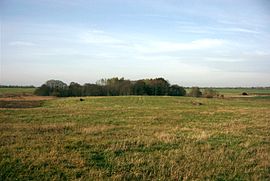
The Crowelin is a desert on a field mark named after him in the municipality of Gützkow in the northwest of the Vorpommern-Greifswald district .
geography
The Crowelin lies 1.25 km north of Gützkow and is bounded by the Dargeziner Bach, also called Krowelinsbach, and the Fritzower Damm, which is extended with the current Kreisstraße 13 to Fritzow, on whose field the Crowelin ends. The field mark is between 12 and 28 m above sea level and is partially cut by creek and meadow depressions.
history
An older settlement of the area is documented by archaeological findings and finds, such as a Neolithic (3500 to 1700 BCE ) trough mill and the remains of two Slavic settlement areas (ceramics, settlement pits and fireplaces). There is also an early German (1230 to 1400) hill tower complex that is well preserved.
The desert and the field mark are named under several names: Krogelin, Kroglin, Kröglin, Krauelin, Kraugelin, Krauglin and the documented version Crowelin with its modernized name Krowelin.
The first information occurs in 1330, when Lippold von Behr as Vogt of Count Johann III. von Gützkow was used on the Crowelin. Lippold called himself "Lyppoldo de Gutsekow, milites" at that time. The first documentary mention of the Crowelin took place on December 21, 1336, when the Vogt of the Gützkower counts called himself "Lyppoldo de Crowlin dictis Beren militibus" .
On August 29, 1353 was in the application for the city of Gützkow by Count Johann III. von Gützkow again expressly called the Crowelin farm with "curiam dictam Crowelin" .
The seat of the bailiff Lippold von Behr and his successors including his son was the "Stüer Gützkow" called tower hill complex, which was part of the settlement upstream to the east and the Meierhof, the current Crowelin desert.
This "Stüer Gützkow" formed the basis for some legends , according to which the Behrs who lived there turned against the Counts of Gützkow and wanted to "disturb" or "control" Gützkow Castle with the tower hill castle (both folk etymological interpretations in Low German ). This is contradicted by the fact that the Counts Lippold name “their dear Vogt” in documents. In addition, there are several similar field names in Pomerania, the meaning of which is described by Vorfeldstörer, i.e. outpost for a castle or town.
In 1356 Count Johann III. on February 10th that his vassal Henning Owstin had given up the Crowelin farm with six hooves and all accessories to six Gützkower farmers (named by name) before the pleban of the Gützkow church by lease. There is a contradiction in the document, because at the same time the count's vassal Winterfeld bequeathed the lands to the Gützkower church.
In the meantime, the settlement and the Meierhof as well as the tower hill castle are abandoned and desolate. Only the piece of land was named both in the files of the Pomeranian Evangelical Church and in the property maps as "Crowelin" (in different spellings) and "the blocks on the Crowelin".
In 1501, Duke Bogislaw X. of the Gützkower Church confirmed the possession of the Crowelin. It is a transsumpt for the document from 1356.
In the visitation protocol of the Gützkow church from 1671 the Crowelin was mentioned as a church field.
At the instigation of the General Superintendent and Plebans of Gützkow, Albert Sigismund Jasper , one was from 1856 to 1859 reclamation of Crowelin causes. Unland was reclaimed, paths were laid and ditches renewed, trees and hedges were planted. The remeasurement resulted in 561 Prussian acres . Then a new lease followed.
The lease of the Crowelin to Gützkower farmers was dissolved in 1952 and the Crowelin was taken over under the name of "Pastorhof" under self-administration of the parish. The parcel thus formed a special operation in the GDR agriculture.
Attractions
- Tower hill castle "Stüer Gützkow" as a ground monument since 1955
literature
- Heinrich Berghaus : Land book of the Duchy of Pomerania and the Principality of Rügen , IV. Part Volume II, Anklam 1868, pp. 136-216 ( Google books ).
- Walter Ewert : Gützkow, the count town on the Peene. Gützkow 1935.
- Marcelle and Fritz von Behr: Documents and research on the history of the Behr family, Gützkower line (The Swan Necks). Volume VII, Part I and II, Bremen 1989.
Web links
Individual evidence
- ^ Pommersches Urkundenbuch (PUB), No. 5210.
- ^ Pommersches Urkundenbuch (PUB), No. 5436.
- ↑ Johann Carl Dähnert : Collection of common and special Pomeranian and Rügischer provincial documents, laws, privileges, contracts, constitutions and regulations. Volume 2, Struck, Stralsund 1767, No. 120, p. 447 ff. (Full text with complete translation, digitized version )
- ↑ Robert Holsten : The Pomeranian field names collection. Böhlau Verlag Cologne Graz, 1963.
- ↑ National Archives Greifswald , LAG-Rep.40 Part VI. No. 82/2, copy of the document dated June 25, 1744.
- ↑ National Archives Greifswald , LAG-Rep.40 Part VI. No. 82/2

