
Züssow
| coat of arms | Germany map | |
|---|---|---|

|
Coordinates: 53 ° 59 ' N , 13 ° 33' E |
|
| Basic data | ||
| State : | Mecklenburg-Western Pomerania | |
| County : | Vorpommern-Greifswald | |
| Office : | Züssow | |
| Height : | 38 m above sea level NHN | |
| Area : | 29.52 km 2 | |
| Residents: | 1298 (Dec. 31, 2019) | |
| Population density : | 44 inhabitants per km 2 | |
| Postal code : | 17495 | |
| Area code : | 038355 | |
| License plate : | VG, ANK, GW, PW, SBG, UEM, WLG | |
| Community key : | 13 0 75 154 | |
| LOCODE : | DE ZSS | |
| Community structure: | 6 districts | |
| Office administration address: | Dorfstrasse 6 17495 Züssow |
|
| Website : | ||
| Mayor : | Eckhart Stöwhas | |
| Location of the community of Züssow in the Vorpommern-Greifswald district | ||
  |
||

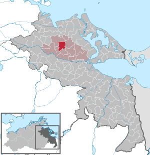
Züssow is a municipality in the district of Vorpommern-Greifswald in Mecklenburg-Western Pomerania (Germany). It has been the seat of the office of the same name since January 1, 2005 . The community is located southeast of the district town of Greifswald . The community of Züssow has 1,438 inhabitants (as of December 31, 2015).
geography
Geographical location
Züssow is 10 kilometers northeast of Gützkow , around 18 kilometers southwest of Wolgast and 19 kilometers southeast of Greifswald . Züssow lies on a plateau 32 to 41 meters above sea level , but the terrain is slightly undulating. In the southeast are the forests of Oldenburg, Nepziner and Karlsburger wood. Coming from Karlsburg, the Swinow as a river forms part of the border of the municipality, partly it crosses this z. B. in Oldenburg and Ranzin. There are no standing waters apart from a few pools and ponds. Moors exist in the ice age depressions, they were superficially exploited in the 19th century. In the Oldenburger Holz there are boiler bogs that are under nature protection.
Community structure
|
|
|
Neighboring communities
These are: Groß Kiesow in the northwest and north, Karlsburg in the east, Klein Bünzow in the southeast, Schmatzin in the south, Gützkow (city) in the southwest and Gribow in the west.
history


local community
In Slavic times, the municipal area belonged to the terra (principality) of Gützkow, in early German times to the county and until 1648 to the Bailiwick of Gützkow. From the Thirty Years' War to 1815, the area belonged to Swedish Western Pomerania and thus to the Wolgast Office, later to the Office and District of Greifswald and after 1815 to the Pomerania Province in Prussia . After 1952, Züssow belonged to the Rostock district and since 1990 to the state of Mecklenburg-Western Pomerania.
Nepzin
An early settlement was proven during the dismantling of a gravel pit east of Nepzin through the discovery of an urn grave field from the pre-Roman Iron Age (−600 to 0) with several clay vessels and various additions.
The place was mentioned in a document in 1358 as nebbetzyn . It was a Slavic foundation. The origin of the name is unclear.
The Nepzin manor belonged to the Rittmeister von Neetzow until 1742, but he went bankrupt. Between 1742 and 1782 the ownership was disputed and a. was called Graf von Putbus. Since 1782 it has belonged to the von Seeckt family, Leopold von Seeckt (1795–1870) was district administrator of the Greifswald district from 1842 to 1865, he was also a member of the Prussian House of Representatives and the Reichstag of the North German Confederation.
Between 1835 and 1880 a Dutch factory was established north of the village, but it was abandoned. There are some litter yards there today.
In 1865 Nepzin had 130 inhabitants, 11 residential houses and 18 farm buildings. Only two farm buildings remain from the estate.
Nepzin was incorporated on July 1, 1950.
The junction of the railway line from Züssow to Wolgast-Hafen is located, meanwhile modernized for the Usedomer Bäderbahn UBB, on the boundary of the town with a railway guard's house and barrier system on the country route to the Karlsburg-Oldenburger Wald.
The old and new land reform farmers were combined to form LPG in 1960 and later assigned to LPG (P) Züssow.
In 2009 Nepzin had 124 inhabitants. In 2013, the through-road to the south (forest) was renovated in a very nice rustic style.
On December 31, 2014, Nepzin had 133 residents with a main residence and 7 with a secondary residence.
On December 31, 2015, Nepzin had 133 residents with a main residence and 7 with a secondary residence.
Oldenburg
Oldenburg was first mentioned in a document in 1514 as Oldenborch . It is a German foundation, as the name (old castle) suggests, but so far there is no archaeological evidence of a castle-like structure. Only Slavic settlement finds to the north-east of the property are known, Berghaus speaks of a castle wall at the point.
In 1865 Oldenburg had 42 inhabitants, 1 railway keeper's house, 3 residential buildings and 3 farm buildings.
Gut Oldenburg was always directly connected to Gut Ranzin as a pertinence, see there for the history. After 1945 the property was settled in the land reform, then it was merged to form the LPG until 1960. This merged from 1967 with the LPG Thurow.
Oldenburg had 44 inhabitants in 2009.
On December 31, 2014, Oldenburg had 37 residents with a main residence and 2 with a secondary residence.
On December 31, 2015, Oldenburg had 33 residents with a main residence and 2 with a secondary residence.

Radlow
Radlow was first mentioned as Radelowe in 1369. It was a Slavic foundation, the possible interpretation of the name is "Hakenpflug". The place was incorporated on July 1, 1950.
On December 31, 2014, Radlow had 29 residents with a main residence and 5 with a secondary residence.
On December 31, 2015, Radlow had 33 residents with a main residence and 5 with a secondary residence.
Ranzin
Ranzin was first mentioned in 1228 as Randensyn . The name means something like "wound" or "early, early", so it cannot be explained precisely.
On December 31, 2014, Ranzin had 184 residents with a main residence and 20 with a secondary residence.
As of December 31, 2015, Ranzin had 182 residents with a main residence and 20 with a secondary residence.
Thurow
Wilhelm Petzsch reported in 1931 on the discovery of urns from private excavations in 1899 near Thurow. These were dated to the pre-Roman Iron Age (600 B.C.E. to 0). Several urns were recovered that had fibulae and other metal objects as dating additions, but these are assigned to the current district of Radlow.
Thurow was first mentioned in 1431 as "Turow". Thurow has the most interesting interpretation of the name: "Aurochs forest". It is a Slavic foundation. Thurow was also owned by Greifswald University since 1634. Before that, the place was desolate because of war and plague, ie it had no inhabitants and the land was fallow.
In 1865, Thurow had 114 inhabitants, 8 residential and 14 farm buildings.
The estate area is still largely preserved. In 2009 Thurow had 71 inhabitants.
On December 31, 2014, Thurow had 61 residents with a main residence and 6 with a secondary residence.
On December 31, 2015, Thurow had 64 residents with a main residence and 6 with a secondary residence.
Züssow
The larger archaeological find area between Radlow and Züssow refers to a Slavic foundation. The settlement in the Züssow district is late Slavic (1000 to 1200). Older settlement records belong to the Radlow district. A tower hill in the estate park belongs to the early German period (from 1230).
In 1404 Züssow was first mentioned as "Sussow". The name means something like "drought".
Züssow was a dominal property from time immemorial, ie it belonged to the dukes and later to the Kingdom of Sweden. It was administered by the Wolgast Office. It was not until after 1800 that von Normann and in 1822 von Krauthof were found to be private owners. Gut Züssow sold them to the von Buggenhagen family in 1830.
Züssow has been touched by the Angermünde - Stralsund railway line since 1863 and had a station here with all accessories (station building with restaurant, signal box, goods shed and several residential buildings for railway officials). This was mainly due to the branching railway line to Wolgast to the island of Usedom, as well as from 1897 the branching small railway line Greifswald - Jarmen (GJK) with its branching from Groß Kiesow to Züssow. This made Züssow a regional transport hub early on.
In 1865 Züssow had 173 inhabitants, 1 church, 1 school, 1 train station, 12 residential buildings, 2 factory buildings (one post and one Dutch windmill each) and 24 farm buildings.
The estate and the train station were also a reason for the larger dairy to settle on the B 111 before 1900; it was regionally important until 1990.
In 1935 the estate had to give up almost all of the usable area, so 10 to 18 hectares were handed over to 20 Westphalian new settlers, so that the estate only had 50 hectares remaining.
In 1945, after the end of World War II who founded Evangelical Church of Pomerania with from Stettin here fled Sisters of Diakonissen- and Bethanien Hospital and deacons of Züllchower institutions and Kückenmühler institutions the Züssower Diakonie institutions (Pomeranian today Diakonieverein e. V.) mentally disabled for maintenance and old people. The facility has been one of the largest employers in the village and the surrounding area since 1990 and has been constantly modernized and expanded. After the resettlement of the residual goods during the land reform of 1945, the LPG was formed with the settlements from 1935 until 1960, which was then merged with the LPGs in the area to form the Groß-LPG (P) Züssow in the 1970s. They built the agricultural complex southwest of the train station, plus the technical base (formerly MAS / MTS) and the ACZ - Agricultural-Chemical Center as a special company for fertilization and weed control in the whole area. Almost all of these properties could be privatized individually after 1990, only the dairy remained and has been in disrepair since then, a furniture store was able to set up on the site, but did not reactivate the old building.
In 1990 Züssow had 1200 inhabitants, in 2009 it had 943.
In 2005, Züssow became the seat and namesake of the combined office - previously the offices of Gützkow, Ziethen and Züssow. The former manor house became the administrative seat.
On December 31, 2014, Züssow had 877 residents with a main residence and 79 with a secondary residence.
On December 31, 2015, Züssow had 878 residents with a main residence and 75 with a secondary residence.
The high number of residents with secondary apartments results from the occupancy of the Diakonie-Anstalt Züssow.
- Wilhelmshöh (desert)
Wilhelmshöh was first named in 1848 as "Wilhelmshöhe". It was laid out as a Vorwerk zu Ranzin by the landlord Wilhelm von Homeyer and then officially named "Wilhelmshöh" after him. In 1964 the place was given up as such, the houses fell into disrepair and were later cleared. Now there is only a warehouse for potatoes in place of the Vorwerk and the village.
Incorporations
On January 1, 2005, the municipality of Ranzin was incorporated into the Oldenburg district.
politics
Coat of arms, flag, official seal
The municipality has no officially approved national emblem, neither a coat of arms nor a flag . The official seal is the small state seal with the coat of arms of the region of Western Pomerania . It shows an upright griffin with a raised tail and the inscription "GEMEINDE ZÜSSOW".
Partner municipality
- Westerrönfeld from Schleswig-Holstein
Attractions
Museums
- Western Pomerania Agricultural Museum in Züssow, mainly relocated to Lüssow to the traditional Western Pomerania estate
Buildings
- Manor house (castle) Ranzin from 1877 based on plans by Eduard Knoblauch .
- Estate distillery in Ranzin from the end of the 19th century, called Villa "Granito"
- Early Gothic Ranzin church from probably the 13th century; Neo-Gothic tower top made of brick from 1861; Grave slabs of the Knight Horn from the 14th century
- Gothic Twelve Apostles Church in Züssow from the 14th century with pulpit from 1634 and late Gothic Twelve Apostles altarpiece .
- Medieval tower hill in Ranzin
- Medieval tower hill in the park in Züssow
- Sender Züssow , four kilometers northeast of Züssow near Moeckow-Berg in the area of the neighboring municipality of Karlsburg
- Devil's chair by Thurow , menhir on the B 111, ground monument (Fpl. Oldenburg 1)
→ See also the list of architectural monuments in Züssow
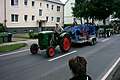
Agricultural Museum Züssow in the pageant for the 600th anniversary

Barrow "Dachsberg" Ranzin

Early German tower hill (Motte) Züssow

Duelstein in the Oldenburger Holz near Nepzin

Kesselmoor in the Oldenburger Holz near Nepzin


Green spaces and recreation
- Bronze Age barrow near Ranzin (Dachsberg)
- Oldenburg wood - with royal oak, "Spider" wayside cross, Kesselmoor, Ulanenberg and Duellstein
- Estate car parks in Ranzin, Radlow, Thurow and Züssow, although except in Züssow they are neglected.
Economy and Infrastructure
Companies
Diakonie is the largest employer. Otherwise the community is characterized by agriculture. There are several agricultural companies. Several trading and commercial enterprises are particularly located in Züssow.
.jpg)
traffic
In 1863 Züssow was connected to the Angermünde – Stralsund railway line . Here the Züssow – Wolgast Hafen railway branches off to Wolgast and has connections through the Usedomer Bäderbahn to Świnoujście (Swinemünde) and Peenemünde on the island of Usedom . Thus, Züssow gained more and more importance as a transfer station in the emerging spa tourism.
In long-distance traffic, Züssow forms the starting point for Intercity Line 30 (Züssow- Hamburg - Cologne - Karlsruhe ) on Mondays and Saturdays . In addition, up to 10 IC and ICE trains on the route Ostseebad Binz / Stralsund - Berlin / Munich stop in Züssow every day . This makes Züssow the smallest place in Germany with an ICE stop.
Since 1897 the place also had a small train connection of the Greifswald-Jarmen-Kleinbahn (GJK) . A special feature here was an access ramp where locomotives and wagons of the small railroad could be "piggybacked" onto platform wagons of the state railway. The line was shut down in 1945 and the tracks were dismantled as reparations .
In 1855 today's B 111 was built from Moeckow-Berg to Gützkow-Chausseehaus. The connections from Moeckow-Berg to Wolgast, as well as today's B 109 and the Kunststraße (later B 96) from Greifswald to Jarmen had already been built.
The Federal Highway 20 is about about 12 kilometers away junction Gützkow reach.
literature
- Heinrich Berghaus : Land book of the Duchy of Pomerania and the Principality of Rügen, Part IV, Volume II, Anklam 1868, pp. 504 ff. And 600 ff.
- Manfred Niemeyer: East Western Pomerania. Collection of sources and literature on place names. Vol. 2: Mainland. (= Greifswald contributions to toponymy. Vol. 2), Ernst-Moritz-Arndt University of Greifswald, Institute for Slavic Studies, Greifswald 2001, ISBN 3-86006-149-6 . Pp. 94, 110, 132, 146
Web links
Individual evidence
- ↑ Statistisches Amt MV - population status of the districts, offices and municipalities 2019 (XLS file) (official population figures in the update of the 2011 census) ( help ).
- ↑ a b c d e f g Amt Züssow, residents of the Züssow district, as of December 31, 2015
- ↑ a b c d e f g Manfred Niemeyer: Ostvorpommern . Collection of sources and literature on place names. Vol. 2: Mainland. (= Greifswald contributions to toponymy. Vol. 2), Ernst-Moritz-Arndt University of Greifswald, Institute for Slavic Studies, Greifswald 2001, ISBN 3-86006-149-6 . P. 94 ff
- ↑ a b c d e f Amt Züssow, residents of the Züssow district, as of December 31, 2014
- ↑ StBA: Changes in the municipalities in Germany, see 2005
- ↑ Main Statute, Section 1, Paragraph 2 (PDF).
- ↑ On Sunday the first ICE goes to Greifswald. , in: Ostsee-Zeitung, local edition Greifswald, March 25, 2011, p. 11
Ahlbeck | Old Tellin | Altwarp | Altwigshagen | Anklam | Bandelin | Bargischow | Behrenhoff | Bentzin | Benz | Mountain wood | Blankensee | Blesewitz | Boldekow | Boock | Brietzig | Brünzow | Bugewitz | Buggenhagen | Butzow | Daberkow | Dargelin | Dargen | Dersekow | Ducherow | Eggesin | Fahrwalde | Ferdinandshof | Garz | Glazov | Görmin | Grambin | Grambov | Greifswald | Gribow | Gross Kiesow | Groß Luckow | Great Polzin | Gützkow | Hammer ad Uecker | Hanshagen | Heinrichswalde | Heringsdorf | Hinrichshagen | Hintersee | Iven | Jarmen | Jatznick | Comb teeth | Karlsburg | Karlshagen | Katzow | Kemnitz | Klein Bünzow | Koblentz | Korswandt | Koserow | Krackow | Krien | Kröslin | Kruckow | Krugsdorf | Krummin | Krusenfelde | Lassan | Leopoldshagen | Levenhagen | Liepgarten | Löcknitz | Loddin | Loissin | Loitz | Lubmin | Luebs | Luckow | Luetow | Medow | Meiersberg | Mellenthin | Mesekenhagen | Mölschow | Mönkebude | Murchin | Nadrensee | Neetzow-Liepen | New Boltenhagen | New Kosenow | Neuenkirchen | Neuenkirchen | Low | Papendorf | Pasewalk | Peenemünde | Penkun | Plow | Polzow | Postlow | Pudagla | Ramin | Rankwitz | Rollwitz | Rossin | Rossow | Rothemühl | Rothenklempenow | Rubenov | Rubkov | Sarnow | Sassen-Trantow | Sauzin | Schmatzin | Schönwalde | Spantekow | Stumble on the Peene | Stolpe on Usedom | Strasburg (Uckermark) | Torgelow | Trassenheide | Tutow | Ückeritz | Ueckermünde | Usedom | Square | Vogelsang-Warsin | Völschow | Wackerow | Weitenhagen | Wilhelmsburg | Wolgast | Wrangelsburg | Wusterhusen | Zemitz | Zempin | Zerrenthin | Ziethen | Zinnowitz | Zirchow | Züssow