
Garz (Usedom)
| coat of arms | Germany map | |
|---|---|---|

|
Coordinates: 53 ° 53 ' N , 14 ° 10' E |
|
| Basic data | ||
| State : | Mecklenburg-Western Pomerania | |
| County : | Vorpommern-Greifswald | |
| Office : | Usedom-South | |
| Height : | 21 m above sea level NHN | |
| Area : | 10.04 km 2 | |
| Residents: | 269 (Dec. 31, 2019) | |
| Population density : | 27 inhabitants per km 2 | |
| Postal code : | 17419 | |
| Area code : | 038376 | |
| License plate : | VG, ANK, GW, PW, SBG, UEM, WLG | |
| Community key : | 13 0 75 034 | |
| Office administration address: | Markt 1 17406 Usedom |
|
| Website : | ||
| Mayor : | Günter Krohn | |
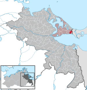
| Location of the municipality of Garz in the Vorpommern-Greifswald district | ||
 _in_SVO.svg) |
||

Garz is a municipality south of the Baltic Sea coast on the island of Usedom . It is located in the eastern part of the Achterland of the island of Usedom directly on the Kleiner Haff ( Stettiner Haff ). The municipality is administered by the Usedom-Süd office based in Usedom.
Geography and traffic
The municipality of Garz extends from the north bank of the Szczecin Lagoon to the eastern border with Poland . At the Haff, Garz borders the municipality of Kamminke to the east and Zirchow to the west . In the north is the municipality of Korswandt and about six kilometers to the north is the seaside resort of Heringsdorf . The eastern area of the Heringsdorf Airport is located in the Garz district.
The federal road 110 runs through the northern area of the municipality, which is located in the island of Usedom nature park . In the northeast are the silted up Zerninsee and the Golm (Usedom) , with 69 meters the highest point on the island of Usedom.
history
On the border of the forest west of the Golm and Swinemoor there is a Rillenstein (cult stone) from the Neolithic (5500 to 1800 BC). The area around Garz was already settled in the younger Bronze Age, as shown by a castle wall from this period on the nearby Golm and excavations made there. This also includes a section wall (Landwehr) west of this castle wall. Some Bronze Age barrows (1800 to 600 BC) have been archaeologically proven directly near Garz and also on the Golm.
The assumption that the place Gridiz visited on the first missionary trip of Bishop Otto von Bamberg in 1124 , where he also consecrated a church, should be equated with Garz, has so far neither been confirmed nor refuted.
A priest Parochianus Petrus from Guardsman in 1231 is the first documented mention of the place today . A second documentary mention was made in 1242, when the Dargun monastery for Gardis and the Kaseburg (today Karsibór ), a few kilometers to the east, first acquired ownership claims. There was probably already a church in Garz at that time, the current one was built around 1450.
Other dates are recorded for Niemeyer. The first mention there is in 1177, when the place was called "Gardis". The next documentary mention took place in 1246 (with PUB 446) as "Gardiz".
After the introduction of the Reformation in Pomerania in 1534 and the secularization that took place after 1537 , Garz was administered by the ducal office of Usedom / Pudagla together with the neighboring town of Kamminke .
During the Thirty Years' War , Garz shared the fate of all places on the island of Usedom, which was initially occupied by the imperial troops. For the expansion of ski jumps on the Swine by order of Wallenstein , Garz residents also had to do manual and clamping services. After the Peace of Westphalia in 1648, Garz became part of Swedish Pomerania . After the Treaty of Stockholm in 1720 it became Prussian. The first time in 1602 mentioned Garzer windmill had in the 18th century the thirlage for the surrounding villages to Königlich- Ahlbeck in the north and Bossin in the West. The founding of the nearby city of Swinoujscie and the expansion of the port there led to an increase in the number of inhabitants in Garz. Mainly craftsmen settled there who went about their work in Swinoujscie, while their families, as Büdner, ran a small farm. In 1852 a cholera epidemic in Garz and the neighboring towns claimed numerous deaths. Ten years later, Garz had 448 inhabitants who lived in 74 houses. More than half of them were Büdner positions.
After the administrative reform in 1815, Garz came to the Prussian province of Pomerania and belonged to the district of Usedom-Wollin from 1818 to 1945 .
Since 1876 Garz was touched a short distance from the Ducherow - Swinoujscie railway line. The most important approach to Garz is still today through a tunnel under this railway line. Since there was a glacial clod on the Golm, two chalk quarries were built around 1880 near the later B 110. But they weren't very productive.
At the beginning of the 20th century, the Świnoujście garrison maintained a parade ground on the area of the municipality, where target practice was also carried out. In order to save transport routes, the field howitzers were housed in a so-called cannon shed on the western edge of the town. This shed also served as a warehouse, as in 1935 with the expansion of the air base was started Garz. Since it impaired flight safety, the Garz windmill was demolished in 1938.
On May 4, 1945, Soviet planes shelled the place. The Garz Air Base had already been vacated by this time. In the attack, which was carried out primarily with cannons and smaller bombs, 22 of 82 farms were completely destroyed and six partially destroyed. One man died from burn injuries. The following day the Red Army occupied the place and the airfield.
After the end of the Second World War , Soviet armored troops were stationed at the air base in addition to aircraft. They used the community area on the Kleiner Haff and in the forest west of the Golm as a training area for their T-54s until they withdrew in 1980 . The Garz Air Base , which was renamed Heringsdorf Airport in 1962 , served the NVA air forces as an alternate airfield. During such missions, radio technical troops were stationed on the Garzer Mühlenberg . From 1962 to the end of the 1970s, the airfield was used by the civil airline Interflug .
The cannon shed was no longer used for military purposes after 1945. Here is a base which was from 1950 Machine Rental Station (MAS) Stolpe the furnished 1960 after founding LPG to the machine and tractor station (MTS) converted. The Polytechnische Oberschule Zirchow conducted ESP and PA lessons here . Since the fall of the Wall , the building has been used by the community and the volunteer fire brigade.
From 1945 to 1952 the municipality, with the part of the district of Usedom-Wollin that remained in Germany after the Second World War , formed the district of Usedom, which in 1952 became part of Wolgast in the Rostock district.
The community has belonged to the state of Mecklenburg-Western Pomerania since 1990. From 1992 it was part of the Ahlbeck office to Stettiner Haff and since 1994 it has belonged to the Ostvorpommern district . On January 1, 2005, the previous office in the then existing Usedom-Süd office and the former district on September 4, 2011 in the Vorpommern-Greifswald district went on.
The Garz- Swinoujscie border crossing , which was closed shortly after the Second World War, opened in April 2007 and could only be used by pedestrians, cyclists and coaches for eight months, as the access road on the Polish side was still under construction. The establishment of a border clearance facility for this short period of time has been criticized. Since Poland joined the Schengen Agreement in December 2007, vehicles with a gross vehicle weight of up to 7.5 t have been allowed to use the second border crossing on the island of Usedom, without border controls.
politics
Election results
With 44.1% of the residents who voted for the AfD in the 2017 federal election, Garz is a stronghold of the AfD.
coat of arms
|
|
Blazon : “In blue a raised golden three-mountain topped with a looking, silver crowned and black haired bust portrait of a woman, on the neck a blue garment hem, lined with silver and a silver necklace with a jewel; on the Dreiberg a silver wall next to a silver castle with three pointed towers with a day-lit floor, the higher and wider middle tower also with an open gate, between the towers a tinned wall; elevated by a right-hand golden bishop's staff. "
The coat of arms was designed by Peter Graff from Garz . It was approved on July 19, 2006 by the Ministry of the Interior and registered under No. 305 of the coat of arms of the state of Mecklenburg-Western Pomerania. |
| Reasons for the coat of arms: In the coat of arms the Dreiberg is supposed to symbolize the 59 m high Golm which rises on the community territory. The portrait of a woman refers to the legend of the Golm Princess, an enchanted princess' daughter who tends her treasures in the mountain. The castle is intended to create a visual reference to the Slavic place name (gard = castle) and to refer to the legendary castle of the Golm Princess. The bishop's staff is supposed to commemorate the stay of Bishop Otto von Bamberg. |
flag
The municipality does not have an officially approved flag .
Official seal
The official seal shows the municipal coat of arms with the inscription "GEMEINDE GARZ * LANDKREIS VORPOMMERN-GREIFSWALD".
Attractions
_von_SO.jpg)
- late Gothic brick and field stone church from the 15th century, see church Garz (Usedom)
- Heringsdorf Airport
See also
literature
- Edmund Kracht: From Gridiz to Garz. History and stories from my homeland. Ed .: Heimatverein Garz e. V. Garz 2007.
- Dirk Schleinert : The history of the island of Usedom . Hinstorff Verlag, Rostock 2005, ISBN 3-356-01081-6 .
Web links
- Literature about Garz (Usedom) in the state bibliography MV
- Municipality of Garz on the website of the Usedom Süd office
Individual evidence
- ↑ Statistisches Amt MV - population status of the districts, offices and municipalities 2019 (XLS file) (official population figures in the update of the 2011 census) ( help ).
- ↑ Arthur Behn: On the geology and the prehistoric and early historical settlement of the Golm . In: The Golm on Usedom . Ed .: Interest group Golm e. V., Baltic Publishing Agency, Greifswald 1996
- ^ Brigitte Metz: Churches on Usedom . Baltic-Verlagsagentur, Greifswald 1993, p. 41.
-
↑ Edmund Kracht: From Gridiz to Garz . P. 8. Kracht refers to:
- Adolf Hofmeister : The Examining Vita of Bishop Otto I of Bamberg . 1924: A monk reports on Otto's boat trip from Bamberg from Stettin to the places Gridiz and Lybecyn .
- Johann Looshorn: The History of the Diocese of Bamberg . Munich 1886-1900: Looshorn names 14th to 16th October 1124 as the period of the trip to Gridiz and Lybin. He equates the place Lybin with Lebbin (today Lubin , part of Międzyzdroje ) on the island Wolin . The common mention of both places that are relatively close to each other, the short travel time and the fact that no place with a similar name could be found near Gartz on the Oder , speak for Garz as a travel destination for Otto von Bamberg, according to Looshorn.
- ^ Metz: Churches on Usedom . Page 41
- ↑ Kracht: From Gridiz to Garz . Page 13
- ↑ Manfred Niemeyer: Ostvorpommern I . Collection of sources and literature on place names. Vol. 1: Usedom. (= Greifswald contributions to toponymy. Vol. 1), Ernst-Moritz-Arndt University of Greifswald, Institute for Slavic Studies, Greifswald 2001, ISBN 3-86006-149-6 . P. 13
- ↑ Bundestag election: Usedom - stronghold of the AfD . ndr.de. Retrieved September 25, 2017.
- ↑ Hans-Heinz Schütt: On shield and flag production office TINUS, Schwerin 2011, ISBN 978-3-9814380-0-0 , p. 359.
- ↑ a b main statute § 1 (PDF).
Ahlbeck | Old Tellin | Altwarp | Altwigshagen | Anklam | Bandelin | Bargischow | Behrenhoff | Bentzin | Benz | Mountain wood | Blankensee | Blesewitz | Boldekow | Boock | Brietzig | Brünzow | Bugewitz | Buggenhagen | Butzow | Daberkow | Dargelin | Dargen | Dersekow | Ducherow | Eggesin | Fahrwalde | Ferdinandshof | Garz | Glazov | Görmin | Grambin | Grambov | Greifswald | Gribow | Gross Kiesow | Groß Luckow | Great Polzin | Gützkow | Hammer ad Uecker | Hanshagen | Heinrichswalde | Heringsdorf | Hinrichshagen | Hintersee | Iven | Jarmen | Jatznick | Comb teeth | Karlsburg | Karlshagen | Katzow | Kemnitz | Klein Bünzow | Koblentz | Korswandt | Koserow | Krackow | Krien | Kröslin | Kruckow | Krugsdorf | Krummin | Krusenfelde | Lassan | Leopoldshagen | Levenhagen | Liepgarten | Löcknitz | Loddin | Loissin | Loitz | Lubmin | Luebs | Luckow | Luetow | Medow | Meiersberg | Mellenthin | Mesekenhagen | Mölschow | Mönkebude | Murchin | Nadrensee | Neetzow-Liepen | New Boltenhagen | New Kosenow | Neuenkirchen | Neuenkirchen | Low | Papendorf | Pasewalk | Peenemünde | Penkun | Plow | Polzow | Postlow | Pudagla | Ramin | Rankwitz | Rollwitz | Rossin | Rossow | Rothemühl | Rothenklempenow | Rubenov | Rubkov | Sarnow | Sassen-Trantow | Sauzin | Schmatzin | Schönwalde | Spantekow | Stumble on the Peene | Stolpe on Usedom | Strasburg (Uckermark) | Torgelow | Trassenheide | Tutow | Ückeritz | Ueckermünde | Usedom | Square | Vogelsang-Warsin | Völschow | Wackerow | Weitenhagen | Wilhelmsburg | Wolgast | Wrangelsburg | Wusterhusen | Zemitz | Zempin | Zerrenthin | Ziethen | Zinnowitz | Zirchow | Züssow