
Swinoujscie fortress

The Swinoujscie fortress was originally a Prussian fortress at the mouth of the Swine to the Baltic Sea , which was intended to protect the sea route from the Oder and Swine to the Baltic Sea. Because of the strategic importance of the Świnoujście estuary , the Swineschanze was created during the Thirty Years' War and was repeatedly the target of military conflicts in the following centuries. In the second half of the 19th century, the Prussian army expanded the fortifications. After the fortress survived the Second World War without major damage, the buildings now partly used by the Soviet Army began to deteriorate in the post-war period . With the withdrawal of the Soviet Army in the early 1990s, the military use of the fortifications ended. The preserved fortifications are located north-east of the city of Swinoujscie in present-day Poland on the islands of Usedom and Wollin and serve as tourist attractions.
history
Thirty Years' War

During the Thirty Years War , Pomerania was occupied by imperial troops in 1628. Colonel Hebron ordered the construction of a rampart at Swine as protection against enemy troop landings , for which the surrounding villages were used for labor services. Danish troops under King Christian IV conquered the hill, which was occupied by 300 men, at the beginning of August after an onslaught of several days. After the defeat in the Battle of Wolgast , however, the Danes withdrew. On June 26, 1630, the Swedish army landed under King Gustav II Adolf near Peenemünde. The imperial troops on Usedom were numerically unable to hold the entrenchments at Peenemünde and Swine.
The Swedish Major General Alexander Leslie ordered the reconstruction of the Swine ski jump in 1634. Again the local population was brought in to serve. The wood for the palisades was fetched from the Kaseburg forest.
After the Peace of Westphalia , the western part of Pomerania with the Oder accesses Peenestrom , Swine and Dievenow belonged to Swedish Pomerania .
Second Northern War
During the Second Northern War , an imperial subsidiary corps moved from Wollin towards the mouth of the Swine in 1659 under the Sergeant-General von Starhemberg . The Swedes gave up the fortifications on the Wolliner Ufer, but reinforced their troops on the Usedom side. At the end of September, however, the Swedes gave up Usedom that was occupied by the imperial troops. On November 4, 1659, the Swedes under Carl Gustav Wrangel managed to recapture.
Swedish-Brandenburg War
In the Swedish-Brandenburg War , the Brandenburg troops under Bogislaw von Schwerin captured the Swine ski jump during the Pomeranian campaign in October 1675. The Brandenburgers occupied the ski jumps at Swine and Peenemünde with smaller teams and withdrew to winter quarters outside of Western Pomerania. In December 1675, Swedish troops under General Conrad Mardefelt landed on Usedom and took both entrenchments after several days of siege. In mid-January, the Brandenburg troops under Bogislaw von Schwerin bypassed the Swineschanze by crossing the ice-covered Stettiner Haff at Kamminke . A direct attack by Schwerin on the Swineschanze on May 22, 1676 was unsuccessful. However, the Swedes cleared the island of Usedom in July of the same year, with the exception of the Peenemünder Schanze, but got it back in the Peace of Saint-Germain (1679) .
In 1692, during an inspection, the decay of the Swineschanzen was discovered.
Great Northern War
In the Great Northern War , the islands of Usedom and Wollin came under Prussian sequestration in 1713 . After Swedish troops drove a small Prussian garrison from Wolgast in February 1715, the Prussians had the fortifications on Usedom reinforced and expanded. 600 farmers from the office and 82 citizens from the city of Wollin had to work at the Swineschanzen. On April 20, 1715, Swedish troops landed on Usedom and took the entrenchments at Peenemünde, Wolgaster Fähre and Swine by April 24. On July 31, Prussian troops under General von Arnim crossed from Wollin to Swineschanze and recaptured the island in the following weeks. In the Treaty of Stockholm in 1720, Sweden finally ceded the islands of Usedom and Wollin to Prussia along with Old Western Pomerania.
Seven Years War
In 1746, on the orders of Frederick II , the construction of the port of Swinoujscie began. During the Seven Years' War , Swedish troops took the Swineschanze in 1757, after which the small garrison consisting of the Prussian militia had evaded to Wollin. After a cold snap at the end of the year, the Swedes withdrew from the island of Usedom so as not to be cut off from supplies by the freezing water. The Prussians who moved up at the beginning of 1758 began to repair the rectangular Swineschanze, also known as the West Redoute . General von Dohna had the engineer lieutenant Löffler erect special fortifications on the Wollin side. The Blockhausschanze was built north of the village of Ostswine, opposite the harbor was the Ostswineschanze and to the south of it the Mövenhakenschanze, all of which consisted of dune sand held by fascines .
In the middle of the year, the Prussians had to withdraw a large part of their troops from Old Western Pomerania and relocate them to Western Pomerania . In July 1758, advancing Swedish troops under Major General von Hessenstein again occupied the island, but were pushed back again by the Prussians at the end of the year. In 1758 the Swedes under Fredrik Axel von Fersen succeeded in taking the West Redoute after being bombarded by sea and land. The Swedes then directed their gunfire against the entrenchments on the Wollin side. The ski jump at Mövenhaken had to be abandoned by the Prussians after it was set on fire. However, they were able to hold the Blockhausschanze and force the Swedish warships to retreat from there. When a small Prussian fleet on the Stettiner Haff was defeated by the Swedish archipelago on September 10, the Prussians had to give up the Wollin side. The Swedes initially occupied the entrenchments with their own troops, but later had the fortifications razed before they finally left the island in 1761.
Coalition wars
During the Second Coalition War , Prussia joined the “armed sea neutrality” alliance directed against Great Britain at the end of 1800. The Swinemünder Schanze was rebuilt in 1812 and armed with fortress guns. After the end of the coalition wars, it fell into disrepair.
In 1812, Prussia, allied with France, had its coastal fortifications expanded in order to be protected against possible Russian or British fleets. Coastal entrenchments were built near Swinoujscie.
Expansion into a fortress


From 1848 the construction of the fortifications of Swinoujscie was ordered and carried out to protect the Świnoujście estuary. From 1852 to 1857 Franz von Kleist was the fortress construction director, who designed the facilities according to the New Prussian fortification manner. It began with Plant I on the east side of the Swine and with Castel Sant'Angelo, later referred to as Plant III, on the west side. These facilities were built in 1848 and 1854 to 1858, respectively. From 1856 a permanent garrison was required to garrison the fortress works, which was guaranteed by a company of the 2nd Jäger Battalion until 1859 . From 1860 to 1864 a battalion of the 2nd Grenadier Regiment took on this task. In 1863 Swinoujscie was declared an independent 3rd class fortress. During the German-Danish War , part of the Prussian fleet had to seek refuge in Swinoujscie and was blocked by Danish ships here.
The rapid modernization of the gun system made it necessary to modernize the gun emplacements and the entire facilities. They were modernized from around 1870 to 1880.
- Plant I.
Plant I was built in a semicircle with an eastward orientation between 1848 and 1860 and consisted of ramparts and trenches in front of it. A central position on the Swine was the gun position to secure the lake entrance. This gun emplacement was a two- to three-story brick building, as shown in the lithograph. The fort had this large trapezoidal building with gun traverses and casemates for the men and the gun material under the outer walls. Fort I was blown up and demolished in the 1970s in connection with the expansion of the port of Swinoujscie.
- Plant II

The planning for the construction of the facilities including the construction of Plant II, which was completed in 1859, had already been in progress since 1848/49. This fort, named "Gerhard", was initially designed for circular fire, but then received additional facilities in the direction of Swine. It should protect the Swine entrance and against sea landings. In 1877 Fort Gerhard - Plant II - was extensively expanded. Large covered ammunition bunkers, barracks and the staff building were built. The gun positions on the trusses were renewed.
- Plant III


Plant III - Castel Sant'Angelo - was created with ditches and ramparts in the shape of a pentagon. A step-shaped brick tower building was erected in the center, which takes its name from the similar shape of the papal castle in Rome. An observation and command post for the entire fortification of Swinoujscie was set up on the upper floor. The gun emplacements were on the ramparts and on the terraces of the central tower. The casemates for crew and ammunition were located in the walls. The fortress commander's apartment was also in the tower. This part of the fortress served to protect the city and the hinterland.
- Plant IV

The construction of Plant IV began in 1856, and in 1861 and 1863 the extensive expansion of the fort "Redoute", as it was also called. After it was removed, it was called battery "A". Its gun positions on the trusses were oriented towards the sea. It had moats, ramparts and casemates. Here is the historical and technical information:
- Construction type - coastal battery
- Year of construction - 1856 - 1861
Surname:
- 1856 - 1861 - Plant IV
- 1863-1878 - battery A.
- 1878-1939 - West battery
- 1939 - 1945 - "Henningsen" battery
- 1946 - 1961 - 485th Soviet coastal battery
Armament:
- 1856 - 1878 - light field artillery
- 1878 - 1919 - 4 cannons 21 cm Krupp
- 1919 - 1935 - 2 flak 8.8 cm
- 1935 - 1942 - 4 cannons 15 cm SKL / 45
- 1942 - 1945 - 4 cannons 15 cm SKC / 28
- 1 cannon 127 mm SKC / 34
- 1 twin flak 37 mm
- 1 quadruple flak 20 mm
- 1946 - 1961 - 3 guns 127 mm Mk.30
In 1878–1887 the Redoute - Plant IV - was extensively modernized. The entire north wall was underbunker with large, well-developed casemates. A covered alarm courtyard was created.
- Frame construction

In 1863 the new construction of the connecting plant between the "Castel Sant'Angelo" - Plant III and the "Redoute" - Plant IV with moats and ramparts to the west began. Casemates for the crew and ammunition were also incorporated there, and a gate with a drawbridge led across the moat towards the city, as the connection southwards along the Swine through the Westernothafen was blocked.
Second World War
During the Second World War , the purpose of the fortress changed significantly. The buildings remained largely unchanged, but the artillery was fundamentally changed. Far-reaching artillery towards the sea and the anti-aircraft defense were major innovations. A radar tower was added to the Castel Sant'Angelo. At the western end of Plant IV, the concrete tower was built in 1941 as an observation and command post. Plant IV was now called "Battery Henningsen".
When a sea landing became very unlikely during the war, the fortress artillery was thinned out in favor of the Atlantic Wall . Towards the end of the Second World War , the city was bombed because there was an important base of the German Navy here. On March 12, 1945, 200 8th Air Force B 17 and B 24 bombers flew an attack on the city, which was then overcrowded with refugees. According to Rolf-Dieter Müller from the Military History Research Office , there were 3,000 to 4,000 deaths, Helmut Schnatz comes to 4,500 in his analysis. The figure of 23,000 dead, which was picked up by some media, rated Schnatz as part of a "creation of legends" that only circulated from the 1990s onwards and which could not withstand scrutiny. Müller also describes them as not durable. Most of the victims were buried in mass graves on the nearby Golm . The air defense of the fortress, which was very heavily armed, could not achieve much due to the lack of support from the air force. 55 percent of the city was in ruins after the air strike.
In April 1945, the 617th Squadron of the Royal Air Force carried out three air raids on the heavy cruiser Lützow, lying south of Swinoujscie in the Kaiserfahrt . After attacks on April 13 and 14 were unsuccessful due to bad weather conditions, on April 16, 1945 18 Avro Lancaster bombers , accompanied by Polish Mustang fighters , hit 14 heavy " Tallboy " bombs (5 each, 5 tons) and 48 lighter bombs (500 kg each) the sinking of the "Lützow". The bomber with the number NG 228 crashed in a forest in the southern part of the island of Kaseburg . On the island known today as Karsibór, a memorial commemorates the British pilots who perished in the attack on the cruiser.
During the war, the fortifications were hardly damaged. It was not until the lack of building materials in the 1960s that their masonry was damaged.
From 1945
Towards the end of World War II, the Red Army occupied Swinoujscie. It made the entire port, the spa gardens and the fortifications a restricted area until 1961. Castel Sant'Angelo, parts of the war port and the barracks on the western edge of the city of Świnoujście were occupied by the Soviet Army until 1992.
In the Potsdam Agreement , the victorious powers laid down the German-Polish border . The report on the Three Power Conference states that - "... The western border of Poland... Runs east of a line from the Baltic Sea, immediately west of Swinoujscie and from there along the Oder ...". On October 6, 1945, the newly formed German authorities officially handed over the city to the Polish administration. The expulsion of the German population who remained in the city or who had returned after the end of the war began.

The last Swinoujscie who were employed as local specialists in the Baltic Red Banner Fleet were evacuated in January 1951. By 1957 the city was divided into a Soviet and a Polish district, into which the Polish population was reluctant to immigrate. The last Soviet naval units and their departments finally withdrew at the end of 1992 and Poland was able to dispose of the entire city area.
The fortress facilities were largely unused after the Soviet Army withdrew in 1961 and 1992. They grew slowly and were forgotten. Uncovering began only after 2000 and the opening of the border to Germany made it interesting for tourism. With the exception of Plant I, which had been removed, the facilities were cleared and made accessible again, and exhibition materials were collected in the buildings that were made accessible to the public.
Today the fortifications of Plant II "Fort Gerhard", Plant III "Castel Sant'Angelo" and Plant IV "Redoute" are mostly well-maintained and prepared as tourist attractions in Świnoujście. They are used as museums and restaurants.

Royal Prussian soldiers in the Swinoujscie fortress

Swinoujscie Fortress Wehrmacht 1939–1945
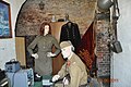
The Red Army in the Swinoujscie Fortress 1945–1992

Fort Gerhard - Swinoujscie - with Polish "fortress commanders"

Commandant's apartment in Castel Sant'Angelo

Casemate bunker in the bolt position

Bunker (l.) And casemates (r.) In Battery Henningsen


Web links
- Castel Sant'Angelo (Polish, German)
Individual evidence
- ^ Robert Burkhardt : Chronicle of the island of Usedom. Section 3: Since the Reformation (1535). W. Fritzsche, Swinemünde 1909, pp. 25-28.
- ^ Robert Burkhardt : Chronicle of the island of Usedom. Section 3: Since the Reformation (1535). W. Fritzsche, Swinemünde 1909, p, 34.
- ^ Paul Menne: The fortresses of northern Germany from the 15th to the 19th century. Göttingen 1939, p. 54.
- ^ Paul Menne: The fortresses of northern Germany from the 15th to the 19th century. Göttingen 1939, p. 68.
- ^ Robert Burkhardt : Chronicle of the island of Usedom. Section 3: Since the Reformation (1535). W. Fritzsche, Swinemünde 1909, pp. 35-38.
- ^ Robert Burkhardt : Chronicle of the island of Usedom. Section 3: Since the Reformation (1535). W. Fritzsche, Swinemünde 1909, pp. 38–41.
- ^ Robert Burkhardt : Chronicle of the island of Usedom. Section 3: Since the Reformation (1535). W. Fritzsche, Swinemünde 1909, p. 50.
- ^ Robert Burkhardt : Chronicle of the island of Usedom. Section 3: Since the Reformation (1535). W. Fritzsche, Swinemünde 1909, pp. 51–57.
- ^ Paul Menne: The fortresses of northern Germany from the 15th to the 19th century. Göttingen 1939, p. 119.
- ^ Paul Menne: The fortresses of northern Germany from the 15th to the 19th century. Göttingen 1939, p. 122.
- ^ Robert Burkhardt : Chronicle of the island of Usedom. Section 3: Since the Reformation (1535). W. Fritzsche, Swinemünde 1909, pp. 67-94.
- ^ Paul Menne: The fortresses of northern Germany from the 15th to the 19th century. Göttingen 1939, p. 131.
- ↑ a b Paul Menne: The fortresses of northern Germany from the 15th to the 19th century. Göttingen 1939, p. 152.
- ^ Paul Menne: The fortresses of northern Germany from the 15th to the 19th century. Göttingen 1939, p. 140.
- ^ Bernhard von Poten : Kleist, Franz von . In: Allgemeine Deutsche Biographie (ADB). Volume 51, Duncker & Humblot, Leipzig 1906, pp. 190 f.
- ^ Paul Menne: The fortresses of northern Germany from the 15th to the 19th century. Göttingen 1939, p. 157.
- ^ Robert Burkhardt : Chronicle of the island of Usedom. Section 3: Since the Reformation (1535). W. Fritzsche, Swinemünde 1909, pp. 169–172.
- ↑ Flyer of the Fort Museum
- ^ Rolf-Dieter Müller : The bombing war 1939-1945 . Links Verlag, 2004, ISBN 3-86153-317-0 , p. 224 .
- ↑ a b Helmut Schnatz : Dresden of the North? The air raid on Swinoujscie on March 12, 1945 , historicum.net, accessed on September 29, 2016.
- ↑ Axel Büssem , Inferno am Ostseestrand , Stern from March 11, 2005, accessed on September 29, 2016.
- ↑ Die Toten auf der Golm Deutschlandradio Kultur, accessed on September 28, 2016
- ^ Rolf-Dieter Müller : The bombing war 1939-1945 . Links Verlag, 2004, ISBN 3-86153-317-0 , p. 224 .
swell
The article was compiled from the information boards in German on the site and from the literature named in the individual references.
Coordinates: 53 ° 55 ′ 3.7 ″ N , 14 ° 17 ′ 3.1 ″ E