
Bugewitz
| coat of arms | Germany map | |
|---|---|---|

|
Coordinates: 53 ° 48 ' N , 13 ° 50' E |
|
| Basic data | ||
| State : | Mecklenburg-Western Pomerania | |
| County : | Vorpommern-Greifswald | |
| Office : | Anklam Land | |
| Height : | 1 m above sea level NHN | |
| Area : | 56.77 km 2 | |
| Residents: | 239 (Dec. 31, 2019) | |
| Population density : | 4 inhabitants per km 2 | |
| Postal code : | 17398 | |
| Area code : | 039726 | |
| License plate : | VG, ANK, GW, PW, SBG, UEM, WLG | |
| Community key : | 13 0 75 020 | |
| LOCODE : | DE U2G | |
| Community structure: | 6 districts | |
| Office administration address: | Rebelower Damm 2 17392 Spantekow |
|
| Website : | ||
| Mayoress : | Ruth Schiller | |
| Location of the municipality of Bugewitz in the Vorpommern-Greifswald district | ||
  |
||

Bugewitz is a community southwest of the Szczecin Lagoon , near the city of Anklam . Since January 1, 2005, the municipality has been administered by the Anklam-Land office based in the municipality of Spantekow . Until December 31, 2004 the community belonged to the Ducherow office . In terms of area, the municipality is the largest municipality in the office and also the one with the lowest population density .
Geography and traffic
Bugewitz is east of the B 109 . Anklam is approx. 15 km northwest and Ueckermünde approx. 18 km east of the municipality. In the north-east the municipality borders with the district Kamp on the Stettiner Haff . Large areas of the municipality are forested.
Districts
- Districts
- Bugewitz
- Bugewitz I
- Lucienhof
- limestone
- Camp
- Rosenhagen
- Housing areas and desertification
- Kuhlerort (desert)
- Rietut (living space)
- Uhlenort (living space)
- Tender stream (desert)
history
Bugewitz
Bugewitz was first mentioned as Bvgoseviz on May 18, 1233. The spelling of the names changed until the current name appeared in 1779. The name is interpreted with the famous . After Bogislaw III. had withdrawn the village of Doblow from the Usedom Monastery, Duchess Miroslawa von Pommerellen and her son Barnim I gave the monastery the place. At the beginning of the 14th century a robbery castle of the von Nienkerken should have existed in the place.
Bugewitz already had three windmills and a water mill before 1835, according to PUM (Preussisches Urmestischblatt). All mills are still available at least until after 1920 according to the measurement table (MTB). South of Bugewitz was the former watermill on Mühlengraben, which was built in 1764. A water wheel about 4 meters in diameter was used to operate the mill. The mill ditch was dammed in order to obtain the necessary energy to drive the water wheel. The watermill was in operation until 1934. The mill wheel was demolished in 1969 because it was in disrepair.
Bugewitz I
With Bugewitz I, the district of Bugewitz has only been named since 1995, which was formed by the estate and some farm workers' houses before 1835 according to the PUM. Only relics of farm buildings remain from the estate. It has become a residential area and is listed as a district in the main statute. It is located one kilometer from the main town. In between there is still a living space where the dairy used to be. All three parts of the village were connected by the Kleinbahn Anklam-Leopoldshagen from 1897 to 1945.
Lucienhof
Lucienhof was first officially mentioned in the municipal directories in 1932. The settlement existed before 1880, according to MTB (measuring table sheet), and only as a single farm. In 1875 the Ducherow - Swinoujscie railway line was completed. It touched the place and it was built with him a station keeper's house. After the track and railway facilities were dismantled after 1945, the town's transport links were also changed. The place itself was enlarged by the land reform, and two farmsteads were created.
In the 21st century, Lucienhof is a somewhat remote place to live.
limestone
Limestone was first mentioned in a document with its current name in 1749. Before that, the square was called Schwalkenheide around 1708 - but there is no further information. Kalkstein was created in 1749 on the initiative of Friedrich II as a colonist village made up of 12 small farms. As was customary at the time, these colonists were certainly smallholders or part-time farmers, each with around 10 hectares of agriculture.
There are different views on the origin of the name. The name limestone can have references to the brick industry in the area: Not far north of the village was a larger clay pit for the brick factories in the area and especially for Ducherow. The Anklam Land office, however, states on its website that Frederick II named the place after a Field Marshal General von Kalkstein who was subordinate to him .
To the east of the village was a single farm that belonged to a post mill standing there. According to MTB, this was created before 1880, but disappeared before that after MTB from 1920. The same applies to two post windmills located northwest of the village, but which were close to the village and not separate.
Limestone came to Bugewitz on July 1, 1950.
There are six farmsteads on each side of the wide avenue. This type of village has survived into the 21st century, only at the mill farmstead to the east has a larger modern settlement formed.

Camp
Kamp was first mentioned in 1357 as Cruneskamp .
Rosenhagen
Rosenhagen was first mentioned in a document with the same name on December 31, 1282. It is a donation from Bogislaw IV to the city of Anklam. It is an early German Sassian (Saxony = Lower Saxony) foundation, a Hagen, i.e. clearing village. It was also recorded under the same name in the Lubin map of 1618.
Rosenhagen is an elongated rural village with several smaller farms, which were more likely to be cattle farmers due to their scenic location.
Rosenhagen had been touched by the Ducherow railway to Swinoujscie since 1876, and since 1897 there was a crossing point of this railway line to the Karniner Bridge with the Anklam - Leopoldshagener small railway line. For the latter, there was a stop on site. Both lines were dismantled in 1945 as reparations.
To the north of the town was the Rosenhagen brickworks, which was called the Anklamer brickworks. According to the PUM, it existed before 1835 but ceased after 1920. The foundation walls can still be seen in the aerial photographs. For this brick factory there was a large clay pit near Rosenhagen, which is now watered, but has also been renatured in parts.
Kuhlerort (desert)
The district of Bugewitz, which in 1618 was referred to as "Kulerort" on the Lubin map, lay on the lagoon. It was a Dutch company that fell wildly after 1920. The place was designated as belonging to Bugewitz in 1932. Only field names now bear witness to Kuhlerort.
Rietut (living space)
Rietut has been drawn as "Ritut" in the measuring table since 1920, but has not been officially registered. It has only been recorded as a place of residence on the official maps since 1995. "Riet ut" is a Low German expression for "tear out". It is a single farm located in the floodplain of the Peene River near Kamp, which is next to the former railway line to the Karniner lift bridge on an island in the floodplain.
Uhlenort (living space)
Uhlenort is a new settlement, first officially mentioned in 1995 on the Usedom regional map. It is identical to the older settlement south of Bugewitz near the former dairy. This residential space is not listed as a district in the main statutes. The name was probably derived from the former Kuhlerort.
Tender stream (desert)
Zartentrom was first mentioned as such in 1865. There was a forester's house and a peat house, but the latter was later abandoned because the peat cutting was stopped after 1950. The forester's house was still occupied as a residential house until the 1990s, but after increasing waterlogging due to the renaturation of the peat bogs around Anklam, it was pulled empty and is now in ruins. The location is still shown in the topographic maps. A building and a boat shed can still be seen in the satellite images.
politics
Coat of arms, flag, official seal
The municipality has no officially approved national emblem, neither a coat of arms nor a flag . The official seal is the small state seal with the coat of arms of the region of Western Pomerania . It shows an upright griffin with a raised tail and the inscription "GEMEINDE BUGEWITZ * LANDKREIS VORPOMMERN-GREIFSWALD".
Attractions
- Anklamer peat bog
- The Bugewitz Church was probably built in the 15th century, was badly damaged in the Thirty Years War and rebuilt in 1718. The church furnishings are uniform with neo-Gothic decor and dates from 1880.
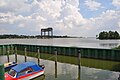
- Ferry port and Marina Kamp on the Stettiner Haff with adjacent mainland connection to the Karnin lift bridge
- Bugewitz Tower Hill
- The Rosenhagen chapel was probably built in the 17th century and remodeled in a neo-Gothic style in the second quarter of the 19th century . The church furnishings with a pulpit altar and a glazed west gallery also date from this time .

Anklamer peat bog near Rosenhagen

Bugewitz Church

Ferry port and Marina Kamp
Connection of the Karnin lift bridge to the mainland - right at Kamp

Rosenhagen Chapel


Culture and regular events
The Weitblick cultural association has been active in the village since 2002 . He organizes concerts, readings, art auctions and a children's theater in town and in the region. There has also been a carnival club in Bugewitz since 1989.
literature
- Manfred Niemeyer: East Western Pomerania. Collection of sources and literature on place names. Vol. 2: Mainland. (= Greifswald contributions to toponymy. Vol. 2), Ernst-Moritz-Arndt University of Greifswald, Institute for Slavic Studies, Greifswald 2001, ISBN 3-86006-149-6 . Pages 77, 134, 151
Web links
Individual evidence
- ↑ Statistisches Amt MV - population status of the districts, offices and municipalities 2019 (XLS file) (official population figures in the update of the 2011 census) ( help ).
- ^ Bugewitz - Kalkstein - Kamp - Rosenhagen , website of the Anklam Land Office, accessed on August 12, 2017.
- ↑ a b c d e f g h i Manfred Niemeyer: Ostvorpommern . Collection of sources and literature on place names. Vol. 2: Mainland. (= Greifswald contributions to toponymy. Vol. 2), Ernst-Moritz-Arndt University of Greifswald, Institute for Slavic Studies, Greifswald 2001, ISBN 3-86006-149-6 . P. 18 ff
- ↑ https://www.kleks-online.de/editor/?element_id=176985&lang=de Mühle Bugewitz
- ↑ Main Statute, Section 1, Paragraph 2 (PDF).
Ahlbeck | Old Tellin | Altwarp | Altwigshagen | Anklam | Bandelin | Bargischow | Behrenhoff | Bentzin | Benz | Mountain wood | Blankensee | Blesewitz | Boldekow | Boock | Brietzig | Brünzow | Bugewitz | Buggenhagen | Butzow | Daberkow | Dargelin | Dargen | Dersekow | Ducherow | Eggesin | Fahrwalde | Ferdinandshof | Garz | Glazov | Görmin | Grambin | Grambov | Greifswald | Gribow | Gross Kiesow | Groß Luckow | Great Polzin | Gützkow | Hammer ad Uecker | Hanshagen | Heinrichswalde | Heringsdorf | Hinrichshagen | Hintersee | Iven | Jarmen | Jatznick | Comb teeth | Karlsburg | Karlshagen | Katzow | Kemnitz | Klein Bünzow | Koblentz | Korswandt | Koserow | Krackow | Krien | Kröslin | Kruckow | Krugsdorf | Krummin | Krusenfelde | Lassan | Leopoldshagen | Levenhagen | Liepgarten | Löcknitz | Loddin | Loissin | Loitz | Lubmin | Luebs | Luckow | Luetow | Medow | Meiersberg | Mellenthin | Mesekenhagen | Mölschow | Mönkebude | Murchin | Nadrensee | Neetzow-Liepen | New Boltenhagen | New Kosenow | Neuenkirchen | Neuenkirchen | Low | Papendorf | Pasewalk | Peenemünde | Penkun | Plow | Polzow | Postlow | Pudagla | Ramin | Rankwitz | Rollwitz | Rossin | Rossow | Rothemühl | Rothenklempenow | Rubenov | Rubkov | Sarnow | Sassen-Trantow | Sauzin | Schmatzin | Schönwalde | Spantekow | Stumble on the Peene | Stolpe on Usedom | Strasburg (Uckermark) | Torgelow | Trassenheide | Tutow | Ückeritz | Ueckermünde | Usedom | Square | Vogelsang-Warsin | Völschow | Wackerow | Weitenhagen | Wilhelmsburg | Wolgast | Wrangelsburg | Wusterhusen | Zemitz | Zempin | Zerrenthin | Ziethen | Zinnowitz | Zirchow | Züssow