Schlossberg (Gützkow)
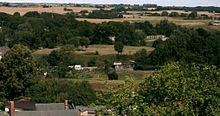
The Schlossberg in Gützkow in the Vorpommern-Greifswald district is an undeveloped elevation north of the city center. Gützkow was an important center and temple of the Slavs in the 11th and 12th centuries . In the 13th and 14th centuries the castle of the Counts of Gützkow was located here . Later a castle of the Dukes of Pomerania stood here . The Schlossberg has been under protection since 1933, and a state soil monument since 1954 .
location
The Schlossberg is located about 250 meters north of the city center and 280 meters south of the federal highway 111 . A stream, the Swinow , runs to the east and north through an extensive, moist valley. The Schlossberg is accessible from the road from the west.
history
Old Slavic layout
About 10% of the more than 5000 finds from 1998 to 2003 come from the Old Slavic period from 700 onwards. It is typical Feldberg pottery . Isolated finds from the Neolithic , however, are insignificant.
Young Slavic castle complex
Around 1100 there was a wooden castle on a natural hill, which stretched over the Schlossberg and the Moosberg, which was then connected to it in the south. On the western slope of this hill there was a Slavic settlement. When Bishop Otto of Bamberg on his second missionary journey to Pomerania in 1128 reached Gützkow, there reigned the prince Mitzlaw as Castellan , of the Pomeranian Duke just a vassal Wartislaw I had become. In 1140 Gützkow was first mentioned as a princely castle. Heinrich the Lion had the castle and town burned down in 1164.
The Schlossberg was separated from the Moosberg in 1175 by a moat. The plateau of the castle complex was raised and straightened, whereby layers of earth up to 2.5 meters thick were applied and leveled. Just two years later, Gützkow and the castle were destroyed again by Danish troops under Waldemar I. Then the Slavic settlement was relocated to the Stadtberg, the moat between Schlossberg and Moosberg was widened to 12 to 15 meters. At the end of the 12th century Gützkow belonged to the Principality of Rügen , which was a Danish fief . That was from 1183 to the Battle of Bornhöved in 1227, whereby the influence of the Rügen princes only lasted until 1209, then the dukes who had been underage up to then took the fief of Denmark directly.
Castle of the Gützkow counts
In the first half of the 13th century, a German castle complex was built on the Schlossberg. Dobroslawa , presumed widow of the last Prince Wartislaw († 1233), is said to have married Jaczo von Salzwedel for the second time , and with him founded the family of the Counts of Gützkow. The castle was expanded as a massive stone structure. It received a keep 16 meters in diameter and 2 meters thick, the foundations of which reached 6 meters in depth. The tower height is therefore estimated at 20 to 25 meters. A drawbridge led to Moosberg, considered bailey served and the Royal Stables was home and other outbuildings. Under the Count of Gützkow, the facility was expanded until the 14th century. After the death of the young Count Johann V during the War of the Rügen Succession in 1351 and the death of his uncle Johann IV after 1359, the castle was inhabited by the widows of the Gützkow Counts until 1378. Then the fiefdom was withdrawn from the Pomeranian dukes.
Ducal castle
In the following time the castle was probably empty and allegedly served as accommodation for robber knights . In 1386 it was captured and destroyed by a contingent of the Greifswald and Stralsund vigilantes. From 1412 to 1422 the castle and county of Gützkow were pledged to Rikold von Lepel , then to Tydeke von dem Borne until 1425 . Subsequently, after the partition of Pomerania under the brothers in 1425 , Duke Barnim VII resided in the castle, which was expanded into a palace during this time . After his death in 1451, the complex began to decline again. The ruin was then used to extract building material. In the drawing from the Stralsund illuminated manuscript from 1615 and on the vedute on the edge of the Lubin map from 1618, only a few remains of the wall can be seen.
Use and ground monument
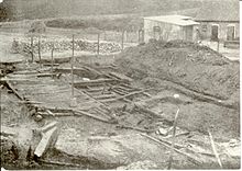
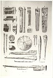
In 1815 the Schlossberg was acquired by Baron von Lepel auf Wieck . He had a brewery built on the north-western edge of the hill, for which part of the elevation was removed. Parts of the former castle smithy came to light. Until 1919 there was a windmill on the Schlossberg . The builder Ramien acquired the grounds of the Schlossberg from Lepelschen Gut in 1930, had it parceled out and leased it to Gützkow citizens as garden plots. When clearing the mountain for the gardens, the foundations of the castle came to light. The owner only allowed short archaeological documentation, then he had all remains of the wall and especially all the foundations made of field stones removed. Ultimately, it was 700 m³ that Ramien had broken out for later use as paving stones. In 1933 part of the mountain in the moat was removed in order to fill in the mill pond to the north on the instructions of the district doctor Peiper. Cantor Ewert, the local conservationist, reported to the authorities that important archaeological layers were being cut. An interruption of the excavations for the purpose of archaeological investigation was not permitted by Ramien, as the district trustee for soil antiquities saw no need for it. Although funds for archaeological excavations had been made available from May 1933 and well-preserved wood from a Slavic settlement was excavated at the end of 1933, Ramien and the mayor Jendis prevented scientific investigations from being carried out. Historically valuable cultural layers were dumped into the mill pond. Only after the mayor was dismissed by the provisional district administrator Ebhardt, who forbade the disruption of the investigations, could these be continued and completed in 1934. In 1939 a large bunker - air raid shelter with two entrances and exits was built in the Schlossberg . After the Second World War, all wood stiffeners were removed from this as building or heating material.
In 1954 the area was measured and added to the monument protection index. In 1964 the Schlossberg was registered as an important ground monument in the list of monuments of the German Democratic Republic and, after 1990, in the European list of monuments. The air raid shelter collapsed in 1997, the collapse funnel showed the mountain stratification and was then filled in. During the extensive reconstructions and renewed archaeological investigations from 1998 onwards, around 5000 finds were recovered by 2002. The Schlossberg has been open to visitors since 2000. A display board provides information about the history of the property.
literature
- Wilhelm Petzsch and Karl August Wilde: excavations on the castle hill of Gützkow . Greifswald: Bamberg 1935.
- Wolf-Dietrich Paulsen, Karl-Eberhard Wisselinck: Gützkow - 875 years. MV-Verlag, Greifswald 2002, p. 14f.
- Werner Wöller: Prehistory and Early History, Middle Ages and Early Modern Times . In: Gützkow local history commission at the Gützkow City Council (ed.): Gützkower Heimatgeschichte . Issue 1, Gützkow 1989, pp. 4-17.
- Werner Wöller: The county of Gützkow - period 1200–1400. In: Gützkow local history commission at the Gützkow City Council (ed.): Gützkower Heimatgeschichte . Issue 2, Gützkow 1990, pp. 14-24.
- Walter Ewert : About the results of the excavations on the Gützkow Castle Hill. In: Gützkow local history commission at the Gützkow City Council (ed.): Gützkower Heimatgeschichte . Issue 3, Gützkow 1997, pp. 4-6.
- Wolf-Dietrich Paulsen: Work and find reports to the Office for Ground Monument Preservation 1998–2003
Individual evidence
- ^ Pommersches Urkundenbuch , Vol. 1, Section 2, Prümers 1877, p. 535 (register).
- ^ Johannes Hoffmann: Studies on the history of the counts of Gützkow. Dissertation, University of Greifswald 1946, Chapter 7, died i. J. 1334 Johann III. or John IV?
Web links
Coordinates: 53 ° 56 ′ 23.2 " N , 13 ° 24 ′ 38.1" E


