
Swinow
| Swinow | ||
 Wet biotopes on the Swinow |
||
| Data | ||
| Water code | DE : 96692 | |
| location | Mecklenburg-Western Pomerania , Vorpommern-Greifswald district | |
| River system | Peene | |
| Drain over | Peene → Baltic Sea | |
| River basin district | Warnow / Peene | |
| muzzle | in the Peene near Gützkow Coordinates: 53 ° 54 '56 " N , 13 ° 25' 25" E 53 ° 54 '56 " N , 13 ° 25' 25" E |
|
| Mouth height | approx. 0.2 m
|
|
| length | 23.5 km | |
| Catchment area | 108 km² | |
| Small towns | Gützkow | |
The Swinow is a small river in Western Pomerania with a length of about 23 km. It rises near Karlsburg in the district of Vorpommern-Greifswald and flows from there in a westerly direction along the federal road 111 to Gützkow . There it flows around the old town and flows into the Peene about 3 km south .
geography
The source of the brook is in the Karlsburger Holz at the eastern end near Pamitz. The stream is fed by numerous ditches from the meadows and moors. It then flows in a westerly direction through the Karlsburger and Oldenburger Holz and then crosses Ranzin and fed a watermill in Gribow until the 1920s . From there, the Swinow runs parallel to the B 111 and passes under it at Upatel , where a new bridge was built in 2003. It runs in a north-westerly curve to the Schiefenberg before Gützkow, where it crosses the Gützkow bypass of the B 111, which was built in 2006. There she reaches the glacial breakthrough valley she has formed through the 16 m high clay block of the plateaus around Gützkow. It reaches the city in stony windings, leaving the Hasenberg behind as an island in the moor meadows. It runs in a tight arc from west to south around Gützkow. At the Schloßberg branches off the artificially created mill stream, which drove the Surrapell Mill, known since 1353, for many centuries. The Swinow was dammed and regulated here by a weir , the so-called “free pouring”. Shortly after the traffic jam, it drove the Görs'sche Mühle built in 1903. From there the stream runs south along the former city limits. In the meadows of the Liebenthal, the stream was straightened in its course. In the 19th century, a long peat cut was dug in the lower reaches of the stream , which the stream flows through before it reaches the Peene.
history

The stream was formed as a drainage of meltwater after the Ice Age. Especially in the area of the city of Gützkow he became a landscape designer by washing out the valley between Schiefenberg and Stadtberg. Since the Stone Age , settlements have been established and archaeologically proven on its banks or in the vicinity. The evidence is particularly dense in the Bronze and Slav times. The exact location of a dugout canoe on its bank around 1920 is not exactly known. The brook was therefore used by boats. The name Swinow-Bach comes from the Slavic and means something like "Schweinbach". At Gützkower Schiefenberg there was the place Swinrowe around 1100 , which was mentioned in a document in 1321. The field name "Dbodstell" referred to the location and archaeological finds confirmed this very impressively.
The Swinow runs mostly in natural meanders , only in the meadows at Liebenthal the brook has been straightened. In the 19th century, a large peat cut was dug on its lower reaches. When the starch factory was built in 1907, a canal was dredged along the Swinow to cut peat on the Peene. At the factory there was a quay for the barges, there is now a resting place for water hikers . There were also water mills on the Swinow, one in Gribow and two in Gützkow.
In 1975 35 beavers from the Elbe - Mulde region were settled here on the Peene between Gützkow and Anklam . They multiplied and now populate the entire Peene and its tributaries, such as the Swinow. Several beaver settlements can be found along the "Schiefenberg" in the softwood quarries on the Swinowbach.
In 1977, when the Swinow Bridge was rebuilt in Teichstrasse, the old mill jam - known as the "Freischütten" - was removed except for a small remainder. Since water regulation during floods is still problematic today, the creation of alternative areas was planned later.
In 2011 the course began to be renatured and larger floodplain areas were created as wetland biotopes . This work stretched from the Hasenberg to the Liebenthal, i.e. around the whole of Gützkow. During this work, some archaeological surprises came to light north of the Schloßberg, such as a cauldron depot made of seven metal cauldrons from the Thirty Years War , which were probably brought to safety from marauding mercenaries there. This depot find is probably relatively unique in terms of its preservation, its size and the historical circumstances of the find, according to the MV state office asking other state offices for comparative examples. Further up the river, another similar basin came to light and in the direction of the former mill dam, an early modern hydraulic engineering appeared, which was first interpreted as a boardwalk, but later as a dam. The dating was very doubtful, as the plant was made of softwood and was out of the question for a dendro sample. The wooden beams crumbled soon after they were exposed.

The breakthrough of the Swinow on Schiefenberg before Gützkow
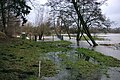
The Swinow floods the city meadows during high water.

Swinow at the confluence of the Mühlbach

Boiler discovery from 2013 - Depot in the found position from the Swinowmoor
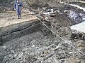
Boardwalk or hydraulic engineering? 2013 excavation at Schlossberg

Swinowbach in front of the confluence of the Peene - peat stitch flows through it, called - canal


Individual evidence
- ↑ a b c map portal environment MV
- ↑ 2004 inventory according to the Water Framework Directive in the Warnow / Peene river basin district, published by the State Office for the Environment, Nature Conservation and Geology Mecklenburg-Vorpommern, Güstrow 2005, p. 4