
Kosenowsee
| Kosenowsee | ||
|---|---|---|

|
||
| Geographical location | District of Vorpommern-Greifswald | |
| Places on the shore | Gützkow | |
| Data | ||
| Coordinates | 53 ° 55 '48 " N , 13 ° 25' 45" E | |
|
||
| Altitude above sea level | 6.2 m above sea level NHN | |
| surface | 16 ha | |
| Maximum depth | 8 m | |

The Kosenowsee is located east of Gützkow in the Vorpommern-Greifswald district . Until the completion of the Gützkower bypass, the federal road 111 ran directly north of the lake.
location and size
The Kosenowsee is max. 647 meters long and up to 343 meters wide. Its area is approximately 16.06 hectares. Around 1905 it was given as 18 hectares, the width as 350 meters. The lake lies in a depression that was created as the thawing relict of a block of dead ice at the end of the Vistula Ice Age . The excess water flowed to the north via a channel to today's Swinowbach. On the western bank there are steep slopes up to 10 m high. At the southern end there is the so-called "Galgenberg", although the origin of the name is unknown, because the Gützkower place of execution was mentioned in a document at the other end of the city on the "Büttelberg", now called Butterberg. The eastern bank shows a flat rise to the surrounding arable land. The northern boundary of the lake valley consists in turn of a mountain with steep slopes, but which has no name. It has a mirror-image shape of the gallows mountain opposite. The lake has no inflow, only surface water feeds it.
history

It takes its name from the village of Kosenow, which according to a legend is said to have sunk into it. On its western edge, relics of a Wendish settlement were found in 1926, to which the documentary name Cusenow , also Cosenow, can be attributed and to whose disappearance the legend certainly refers.
With the construction of the road embankment, it had already been built in the Middle Ages, but was only expanded in its present form around 1850, the natural drainage channel was built. The result was that in heavy rain or persistent precipitation the lake overflowed and rose to the surrounding slopes. In 1864 a house was built at the current location of the restaurant, which was later expanded into a fisherman's farm. Around 1900 it was bought by the small farmer and innkeeper Rudolf Anners, who expanded the homestead and built a restaurant with a dance hall. If the water level rose too much, this property was at risk. Therefore, experts were consulted who even made the suggestion to dig a drainage channel in the direction of Peene (source: municipal protocols). But then they agreed on the variant of a pipeline with an inlet that drains the water at a certain water level. In 1928 this pipeline was laid, which discharges the water in the direction of the old drainage channel over the ditch system on the Hasenberg to the Swinowbach.
After this drainage was guaranteed, a hiking trail was leveled around the lake by means of job creation measures from 1928, benches were built and the vegetation was thinned out. Paths were laid out and trees were planted in the area between the restaurant and the swimming area. The lake became a kind of park.
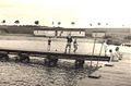
In 1938 a bathing establishment was built on the north-eastern shore of the lake. A cloakroom and changing room was built, which was later given two wings with changing rooms. The cloakroom check-in was in the middle, the pool attendant's office in front. The attraction, however, was the pier with the wooden diving platform.
When the "Barlay" circus made a guest appearance in Gützkow in the 1960s, its 5 elephants were led to bathe in the lake. These scraped against the wooden frame of the diving platform and this broke off because the posts were probably already rotten under water. Then a new U-shaped pier was built around 1964, which was even provided with real 25 m swimming lanes. This jetty was then rebuilt in the 1980s with iron piles and the swimming lanes were expanded to the standard size of 50 m. A diving tower was no longer permitted due to the insufficient water depth and the remains of the pile in the ground.
As a designated recreational area, the lake was a popular excursion destination in the whole area, especially during the GDR era. It can be completely hiked around on a path near the shore, the path length is 1.68 km. An open-air theater was built in the 1970s and the city's beach festival was held there every year.
Since 1991, a floating deep water aeration system has been installed at the deepest point at 8 m in order to reduce the cloudiness and the multiplication of algae. At the same time, a protection zone was set up all around to prevent nutrient inputs from the arable land. In the meantime, parts of the eastern edge area have been provided with a tree protection belt.
The path around the lake was re-paved through job- creation measures, as the overflow at the restaurant was blocked several times and the path around the lake was softened and muddy.

Kosenowsee - systems from 1928

Kosenowsee - bathing establishment 1940

Kosenowsee - bridge with tower in winter 1940
Kosenowsee - bathing establishment 1960

Kosenowsee - bathing establishment with jetty 1964

Kosenowsee - bathing establishment with jetty 2002


Restaurant by the lake
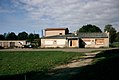
As mentioned historically, a restaurant on the lake was set up before 1900. The Anners family has been working there since then; in addition to the restaurant, they also ran a small farm as a sideline and fishing on the lake. The restaurant subsequently received a dance hall. The facility was named: "Under the four lime trees" - the name given to the 4 trees planted in a row in front of the house, under which the beer garden was set up in summer. When the family died out, the house deteriorated. In 1972 the city built a new restaurant, the consumer-operated "Seeperle". It in turn became a center of attraction for the area. After 1990, a potential investor then leased, but the purchase did not materialize. It was similar with the next applicant, who also failed. A company from the city then bought the property, modernized it and leased it to a Greek family who have been successfully running the “Athos” restaurant ever since. The company is planning a campsite and an extensive leisure facility next to the restaurant between the lake and the Fährdamm. The plan is in the approval phase.
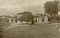
Anners restaurant 1938

Restaurant "Seeperle" 1985
Ruins of the "Seeperle" restaurant in 2003

Restaurant "Seeperle" as a short interim solution

Restaurant "Athos" 2012


literature
- A. Bellmer: Investigations on lakes and Söllen Neuvorpommern and Rügen . In: Rudolf Credner (Hrsg.): Yearbook of the Pomeranian geographical society, seat of Greifswald . Greifswald 1905. p. 463f. ( Digitized version )
- Jodocus Donatus Hubertus Temme : The Pomeranian Sodom and Gomorrha from The folk tales of Pomerania and Rügen. Pp. 208-209 . Berlin 1840 ( Wikisource )
- Walter Ewert : Gützkow, the count town on the Peene. Gützkow 1935.
- Wolf-Dietrich Paulsen, Karl-Eberhard Wisselinck: Gützkow - 875 years . MV-Verlag, Greifswald 2002
- Wolf-Dietrich Paulsen: Chronicle of the city of Gützkow - update from 1996 - 600 p. - digitized in the museum PC - printed form from 1997 350 p. In the museum