
Booed
| coat of arms | Germany map | |
|---|---|---|

|
Coordinates: 52 ° 22 ′ N , 8 ° 19 ′ E |
|
| Basic data | ||
| State : | Lower Saxony | |
| County : | Osnabrück | |
| Height : | 49 m above sea level NHN | |
| Area : | 110.75 km 2 | |
| Residents: | 12,687 (Dec. 31, 2019) | |
| Population density : | 115 inhabitants per km 2 | |
| Postal code : | 49163 | |
| Primaries : | 05471, 05475 | |
| License plate : | OS , BSB, MEL, WTL | |
| Community key : | 03 4 59 013 | |
| Community structure: | 3 districts | |
| Address of the municipal administration: |
Bremer Strasse 4 49163 Bohmte |
|
| Website : | ||
| Mayoress : | Tanja Strotmann ( independent ) | |
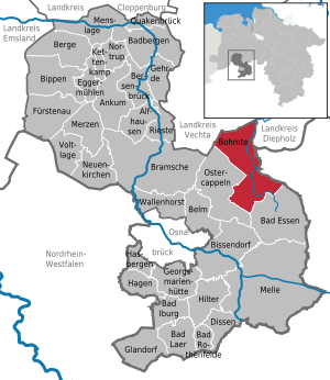
| Location of the municipality of Bohmte in the district of Osnabrück | ||
  |
||

Bohmte is a municipality in the east of the Osnabrück district in Lower Saxony .
geography

Bohmte is located a few kilometers north of the Wiehengebirge on the edge of the North German Plain . The Hunte flows through the municipality from southeast to north. In the southwestern town of Herringhausen-Stirpe-Oelingen, Bohmte has a port on the Mittelland Canal . The Dümmer begins about 300 meters north of the municipal boundary . The DiVa Walk runs through Bohmte .
climate
Temperate maritime climate influenced by humid northwest winds from the North Sea. The long-term average air temperature in Bohmte reaches 8.5–9.0 ° C and around 700 mm of precipitation falls. Between May and August, an average of 20-25 summer days (climatological term for days on which the maximum temperature exceeds 25 ° C) can be expected.
Community structure
The following districts are distinguished in the population:
|
|
|
|
|
|
|
In contrast, the main statute of the municipality only distinguishes between the three localities Bohmte, Herringhausen-Stirpe-Oelingen and Hunteburg.
Neighboring communities
The community borders Bad Essen in the south, Ostercappeln in the west, Damme ( Vechta district ) in the north, Hüde and Stemshorn (both Diepholz district ) in the northeast and the North Rhine-Westphalian community of Stemwede ( Minden-Lübbecke district ) in the east .
history
Bohmte was first mentioned in a document in 1074. With this document, dominus Gisilbertus and domina Cuniza transfer Essen and Bohmte to Bishop Benno II and the Osnabrück church, apparently the whole place. You are guaranteed 4 pounds of tenth money for life from goods in Bohmte and other places as well as two wild boars and 2 hinds.
Mining
In Bohmte there was the coal mine Caroline from 1867 to 1875, and from 1911 to 1925 the colliery insistence of the union insistence, which promoted Wealdenkohle . This makes Bohmte the northernmost German hard coal mining site .
time of the nationalsocialism
At the beginning of 1945 two British airmen who had not landed in Bohmte were murdered in Bohmte . The proceedings against the local group leader of the NSDAP were discontinued in 1959 despite the proven complicity due to the impunity law .
Incorporations
Today's unified municipality Bohmte was created on July 1, 1972 through the amalgamation of the municipalities Bohmte, Herringhausen, Meyerhöfen, Schwege, Stirpe-Oelingen and Welplage on the occasion of the district reform in Lower Saxony .
Outsourcing
On July 1, 1975, an area with then around 100 inhabitants was assigned to the neighboring municipality of Ostercappeln.
Population development

The following overview shows the population of Bohmte in the respective territories and on December 31st.
The figures are updates by the State Office for Statistics and Communication Technology Lower Saxony based on the census of May 25, 1987 .
The data from 1961 (June 6) and 1970 (May 27) are the census results including the places that were incorporated on July 1, 1972. The territorial status on July 1, 1975 applies.
| year | 1961 | 1970 | 1987 | 1990 | 1995 | 2000 | 2005 | 2010 | 2011 | 2015 | 2017 | 2018 |
| Residents | 9.009 | 9,338 | 10,062 | 10,695 | 12,352 | 13.191 | 13,318 | 12,935 | 12,877 | 12,637 | 12,612 | 12,689 |
Explanation of the place name
Old names of the place are 1047 Bamwide, 1088 Bomwide, 1090 Bamwide, 1090 Bonwide, 1188 Bomwede, 1310 Bowede, Bomethe, 1402 Bomde, 1423 Boemwede, 1604 Bombwede, 1625 Boembte, 1651 Bombte, 1652 Baumte, 1772 Bomte, 1789 Bomwedde and 1823 Booed. This place name has developed from Bom- / Bamwide to Bohmte. It is hardly possible otherwise than to derive Bohmte from “Bōm-wide” for “tree forest”. “Wide, wede” is Low German for “forest”. This is confusing: tree and forest; because every forest consists of trees. Therefore “tree” could be used in the sense of “timber” in this case. The green tree was called in very old times by "tere", while "bom" stood for "dry tree, beam". Probably the “Bom-” in this place name can be seen as “Bauholz”. But it is not certain.
politics
Municipal council
The parish council currently has 30 members from four parties or groups. Then there is the mayor.
The following table shows the local election results since 1996.
| Council of the Bohmte municipality: election results and municipal councils | |||||||||||||||||||
|---|---|---|---|---|---|---|---|---|---|---|---|---|---|---|---|---|---|---|---|
| CDU | SPD | GREEN | FDP | LEFT | total | electoral participation |
|||||||||||||
| Electoral term | % |
|
% |
|
% |
|
% |
|
% |
|
% |
|
% | ||||||
| 1996-2001 | 51.2 | 17th | 32.6 | 10 | 7.3 | 2 | 8.8 | 2 | - | - | 100 | 31 | 70.1 | ||||||
| 2001-2006 | 56.5 | 18th | 32.5 | 10 | 4.7 | 1 | 6.3 | 2 | - | - | 100 | 31 | 63.2 | ||||||
| 2006-2011 | 49.4 | 15th | 37.7 | 11 | 5.0 | 2 | 7.8 | 2 | - | - | 100 | 30th | 53.8 | ||||||
| 2011-2016 | 43.85 | 13 | 41.99 | 13 | 8.79 | 3 | 3.57 | 1 | 1.79 | - | 100 | 30th | 59.74 | ||||||
| 2016-2021 | 44.63 | 13 | 40.57 | 12 | 8.97 | 3 | - | - | 5.82 | 2 | 100 | 30th | 57.94 | ||||||
|
Percentages rounded. Sources: State Office for Statistics and Communication Technology Lower Saxony, District Osnabrück. In the case of different information in the sources mentioned, the data from the State Office for Statistics and Communication Technology were used, as they are generally more plausible. |
|||||||||||||||||||
mayor
- from 2019 Tanja Strotmann
- 2003–2019 Klaus Goedejohann (CDU), first full-time mayor from January 1, 2003
- 2001–2002 Rolf Flerlage (CDU)
- 19 ?? - 2001 Hubert Haskamp (CDU)
- 1972–1994 Manfred Hugo (CDU)
Town twinning
- Gützkow , District of Vorpommern-Greifswald, Mecklenburg-Vorpommern (since 1991)
- Bolbec , Seine-Maritime, France
Culture and sights


Buildings
- The “Bohmter Kotten” - a building formerly used for agriculture - was renovated by the municipality in 1989 and has since been used for cultural, artistic and charitable events as well as for the work of the municipal council. The Bohmte community library is housed in the attic of the “Bohmter Kotten”.
- Bohmte station
- St. John's Church
- St. Thomas Church
- St. John's Church Arenshorst
- The mill was built as a brick structure in 1871 and renovated in 1989
Architectural monuments
Regular events

Celebrations:
- “Fun on the street” - last weekend in April
- Shooting festival in Bohmterheide - Pentecost
- Shooting festival in Bohmte - 1st weekend in July
- Shooting festival in Stirpe-Oelingen - 2nd weekend in July
- Shooting festival in Hunteburg - 4th weekend in July
Markets:
- Open day at the local sports airfield in Bohmte / Bad Essen with a car and trade show - May 1st
- Herringhausen-Stirpe-Oelingen harvest festival with harvest market - 1st weekend in September
- Bohmter market with trade show - 4th weekend in September
- North German pony market in Hunteburg - 2nd weekend in October
Christmas markets:
- Nikolausmarkt in Bohmte - 2nd Advent
- Christmas market in Hunteburg - 3rd Advent
education
- School kindergarten at the Erich Kästner School
- Erich Kästner School (elementary school for students of all denominations)
- Christophorus School (elementary school for students of the Catholic faith)
- Herringhausen primary school
- Oberschule Bohmte (former secondary and secondary school Bohmte)
- Wilhelm Busch School, Hunteburg (elementary school and secondary school)
- Astrid Lindgren School
Infrastructure
traffic
Rail transport


The station Bohmte is located on the railway line Osnabrück-Bremen and by regional express trains on the line RE 9 (Osnabruck - Bremen - Bremerhaven; operated by DB Regio ) served. A freight yard is located on a separate route operated by the Verkehrsgesellschaft Landkreis Osnabrück (VLO, formerly Wittlager Kreisbahn ) in the northern district of Hunteburg (Hunteburg has about 4000 inhabitants). This Wittlager Kreisbahn operated from 1900 to the 1960s between Preußisch Oldendorf and Hunteburg. Your Bohmte Ost station , which is still used occasionally by the Minden Museum Railway , borders the Deutsche Bahn AG station to the northeast.
Bus transport
The VLO Verkehrsgesellschaft Landkreis Osnabrück mbH operates regular bus services in the Bohmte area. From the central bus station, directly at the train station in Bohmte, there are some lines of the Verkehrsgemeinschaft Osnabrück (VOS) to Hunteburg or Damme (212), school buses (214) towards Herringhausen, Stirpe, Levern and Evinghausen as well as to Venne via Schwagstorf and Herringhausen, Leckermühle ( 275). Leckermühle is an important stop as a hub, from where there is an hourly bus connection to Osnabrück (276), Venne (275,214) Pr. Oldendorf (276) via Bad Essen and its localities.
Road traffic
The federal highways 51 , 65 and the B 218 , which ends there, meet near the southwestern municipal boundary , at the Leckermühle roundabout . The B 51 and B 65 reach the intersection on a common route coming from the south-west of Osnabrück and continue from there separately in the direction of Bremen and Hanover .
Because of the heavy through traffic that is concentrated on the historic village street, the town center is being redesigned to calm traffic as part of the “ Shared Space ” concept . The basic principle of "more safety through fewer rules" has been implemented since summer 2006 at two intersections by dismantling 60% of the traffic signs, partly colored road surfaces and roundabouts. Since May 19, 2008, all traffic signs in the 450 meter long section have been dispensed with, and the strict separation of lane and sidewalk has been abolished.
air traffic
Bohmte owns a small airfield . The nearest international airport is Münster-Osnabrück Airport in Greven .
shipping
Bohmte has a small bulk goods port ( Umschlagstelle Bohmte ). A company called HWL (Hafen-Wittlager-Land-GmbH), founded by some regional authorities, is trying to obtain subsidies for the construction of a container port in the district of Stirpe-Ölingeen.
Personalities
Sons and daughters of the church
- Johann Heinrich Hadewig (1623–1671), Protestant pastor and hymn poet, b. in Arenshorst
- Franz Schmedt (* 1932), journalist, b. in Hunteburg
- Martin Schwanholz (* 1960), politician (SPD)
Associated with Bohmte
- Johann Ludwig Bramsch (1811–1877), entrepreneur, was baptized in Bohmte in 1811
- Karl Janisch (1870–1946), mechanical engineer, died in Schwegermoor
- Reinhold Tiling (1893–1933), engineer, pilot and rocket pioneer, owned a workshop in Bohmte
- Rudolf Seiters (* 1937), politician (CDU), founder of the Junge Union Bohmte (1958), Federal Minister of the Interior (1991–1993), Vice President of the German Bundestag (1998–2002), President of the German Red Cross (2003–2017)
- Manfred Hugo (* 1942), lawyer and district administrator of the Osnabrück district, was mayor of the municipality from 1972 to 1994
Web links
Individual evidence
- ↑ State Office for Statistics Lower Saxony, LSN-Online regional database, Table 12411: Update of the population, as of December 31, 2019 ( help ).
- ↑ §1, sentence (2) of the main statute for the municipality of Bohmte in the version of the amendment statute of March 22, 2004
- ^ History of the village of Bohmte. Retrieved October 29, 2018 .
- ^ LG Osnabrück, October 7, 1959 . In: Justice and Nazi crimes . Collection of German criminal judgments for Nazi homicidal crimes 1945–1966, Vol. XVI, edited by Irene Sagel-Grande, HH Fuchs, CF Rüter . Amsterdam: University Press, 1976, No. 482, pp. 47–59 Subject matter of the proceedings: shooting of two British airmen who had landed in an emergency while they were being transported away after their arrest ( memento of the original of February 6, 2017 in the Internet Archive ) Info: The archive link was automatically inserted and not yet checked. Please check the original and archive link according to the instructions and then remove this notice.
- ↑ a b c Federal Statistical Office (ed.): Historical municipality directory for the Federal Republic of Germany. Name, border and key number changes in municipalities, counties and administrative districts from May 27, 1970 to December 31, 1982 . W. Kohlhammer, Stuttgart / Mainz 1983, ISBN 3-17-003263-1 , p. 260 .
- ↑ State Office for Statistics and Communication Technology Lower Saxony, population update ( page no longer available , search in web archives ) Info: The link was automatically marked as defective. Please check the link according to the instructions and then remove this notice.
- ^ Jürgen Udolph (research): The "place name researcher". In: website NDR 1 Lower Saxony . Archived from the original on August 17, 2014 ; accessed on August 3, 2019 .
- ↑ Quick report on the 2016 municipal elections on September 11 , 2016 , accessed on June 13, 2019
- ↑ State Office for Statistics and Communication Technology Lower Saxony, Table 5000311
- ↑ Landkreis Osnabrück, official final results of the district election on September 9, 2001 ( Memento from May 25, 2005 in the Internet Archive ) (PDF; 528 kB)
- ^ The local elections for the district of Osnabrück on September 11, 2011 (also includes 2006 results). (PDF 8.0MB p. 51 column "Municipal elections") Osnabrück district, accessed on March 6, 2016 .
- ↑ Announcement of the municipality of Bohmte from May 29, 2019, accessed on November 11, 2019
- ↑ City Factory Bohmte - Our Church - Library. In: www.bohmte.de. January 5, 2017, accessed January 5, 2017 .
- ↑ Interview with the traffic planner Hans Mondermann: The ax in the forest of signs. In: Spiegel Online . December 8, 2005, accessed January 5, 2017 .
- ↑ Benno Schirrmeister: With Habermas across the street. In: taz.de . Retrieved January 5, 2017 .
- ↑ Bohmte has Germany's first center without signs. In: Spiegel Online. June 21, 2008, accessed December 2, 2014 .
- ↑ spiegel.de / Philipp Seibt: A container port is being built here - and nobody needs it , August 6, 2018
- ↑ see also www.containerhafen-bohmte.de
Alfhausen | Ankum | Bad food | Bad Iburg | Bad Laer | Bad Rothenfelde | Badbergen | Belm | Mountains | Bersenbrück | Tapping | Bissendorf | Boiled | Bramsche | Dissen at the Teutoburg Forest | Eggermühlen | Fürstenau | Gehrde | Georgsmarienhütte | Glandorf | Hagen am Teutoburg Forest | Hasbergen | Hilter at the Teutoburg Forest | Kettenkamp | Melle | Menslage | Merzen | Neuenkirchen | Nortrup | Ostercappeln | Quakenbrück | Rieste | Voltage | Wallenhorst