
Bad Laer
| coat of arms | Germany map | |
|---|---|---|

|
Coordinates: 52 ° 6 ' N , 8 ° 5' E |
|
| Basic data | ||
| State : | Lower Saxony | |
| County : | Osnabrück | |
| Height : | 79 m above sea level NHN | |
| Area : | 46.81 km 2 | |
| Residents: | 9110 (Dec. 31, 2019) | |
| Population density : | 195 inhabitants per km 2 | |
| Postal code : | 49196 | |
| Area code : | 05424 | |
| License plate : | OS , BSB, MEL, WTL | |
| Community key : | 03 4 59 005 | |
| LOCODE : | DE BLA | |
| Community structure: | 6 parts of the community | |
| Address of the municipal administration: |
Glandorfer Strasse 5 49196 Bad Laer |
|
| Website : | ||
| Mayor : | Tobias Avermann ( independent ) | |
| Location of the community Bad Laer in the district of Osnabrück | ||
  |
||

Bad Laer [ -ˈlɑːʁ ] is a municipality in the south of the district of Osnabrück in Lower Saxony . The spa areas in the municipality of parts Hardensetten , Müschen Westerwiede and Winkelsetten the community is as Sole since 1975 heilbad nationally recognized and carries since then the title bath . The local authority has existed in its current form since the spin-off of the municipality of Glandorf on May 1, 1981.
geography
location
Bad Laer is located in a climatically favorable transition area between continental and maritime climates on the wooded southwest slope of the Blomberg, an extension of the Teutoburg Forest in the Osnabrücker Land in the border area to the Münsterland and to East Westphalia . The highest point is the Kleine Berg ( 208 m above sea level ) on the eastern border of the municipality.
Community structure
Parts of the municipality and number of inhabitants (as of 2006):
- Hardensetten (783)
- Laer (5740)
- Müschen (830)
- Remsede (1149)
- Westerwiede (419)
- Angle chains (341)
Since 2007 there has only been statistical data on the total number of inhabitants in the municipality, no longer on that of the individual districts.
Neighboring communities
Bad Laer borders Glandorf in the west, Bad Iburg in the north, Hilter am Teutoburger Wald and Bad Rothenfelde in the east and the North Rhine-Westphalian cities of Versmold ( Gütersloh district ) and Sassenberg ( Warendorf district ) in the south .
history
Archaeological finds of equipment and weapons from the Mesolithic indicate that the area northwest of the brine spring in the Westerwiede farming community has been used for agriculture and has been inhabited for at least 10,000 years.
Laer was first mentioned in a document on December 8, 851. In the document, King Ludwig the German gave several farms in Laer and Erpen to the Marienkloster in Herford , in the document Arpingi called: “[…] in pago, quod dictur Sutherbergi, in villa quae nuncupatur Lodre […] et in eodem pago, in villa quae vocatur Arpingi. “Lodre is today's Bad Laer, which was spelled Loder or Loer until the 17th century and was only later translated into Laer.
It was probably written in the district of Remsede, the name probably derives from the Old Saxon Hramasithi or Hramaslehti (field of ravens), the first Christian church in the area. The inscription "Aedificatum anno DCCXXXIV", which is on a stone of the archway of the St. Antonius Church , Jostes and Effmann describe as a forgery, but they do not rule out that there are still remains of the first building in the church. An indication of this could be that the Church dedicated to St. Hermit Antonius is consecrated, which according to Kampschulte assigns a great age to all churches concerned. In addition, the Remseder "dangers" are highly characteristic. These are ancient pilgrimages that meet four times a year. In the vernacular it was said: “Riämser gefaor kümp veermol int jaor.” The faithful should go to St. Antonius made a pilgrimage to Remsede to ward off the plague and other epidemics. Processions are even said to have come from Cologne, and the route they took is still called the Kölner Weg in the neighboring community of Glandorf.
In the 17th and 18th centuries, spinning and weaving was an important source of income for the population and the parish was a linen center of the Osnabrück region until the 19th century. The linen from Laer had a particularly good reputation, as two "laying masters" checked the quality of the linen and determined the quality classes.
The carbonic acid-rich brine that naturally emerges in Springmeier's Kolk has deposited a lenticular rock plate approx. 1.4 × 0.9 km in size since the last Ice Age. After the gradual sweetening of the kolk spring, the extraction of evaporated salt, which the hereditary kettle Pelster had started in 1580, was given up again. In 1836 the full heir Springmeier opened a bathing establishment and converted his mansion into a spa house. In 1969 the municipality of Bad Laer took over source rights and bath house. In addition to the Martin Spring, drilled in 1938, the new well sunk in 1973 brought abundant inflows of brine with 7% salt content, which enabled the construction of a modern spa center. The best overview of the spa park is obtained from nearby Blomberg, which is characterized by a special flora with light beech forests.
On September 1, 1975, the community name was preceded by the addition of bath .
In 2010, the old spa park in Bad Laer was redesigned into an adventure spa park with a new water treading pool, barefoot path and exercise course and the promenade on the Glockensee through which the Salzbach flows. A covered inhalation pavilion was built between Kolk and Martinsquelle, where the brine trickles down the thorn walls both outside and inside, like a graduation tower, and can be inhaled as a salty aerosol.
Place name
Former place names of Laer were in the years 851 Lodre, 1074 Lathara, 1171 Lothere, 1447 Loder and 1565 Laer. The name contains an ancient, Germanic r-element as it occurs in names such as Atter, Emmer, Fahner, Fehmarn, Freren, Letter, Limmer, Jever. It is very likely that the r-element is based on a root that indicates water, dirt and moisture. The origin of the place name Bad Laer is obviously due to a damp place, a place near the water / muddy water.
Incorporations
On July 1, 1972, the communities of Averfehrden, Glandorf, Remsede , Schierloh, Schwege, Sudendorf and Westendorf were incorporated.
Outsourcing
On May 1, 1981, the community of Glandorf was spun off. Of the places incorporated on July 1, 1972, only Remsede remained near Bad Laer.
Population development

The following overview shows the population of the municipality Bad Laer in the respective territories and on December 31st.
The figures are updates by the State Office for Statistics and Communication Technology Lower Saxony based on the census of May 25, 1987 .
The data from 1961 (June 6th) and 1970 (May 27th) are the census results including the town of Remsede, which was incorporated on July 1st, 1972.
| year | Residents |
|---|---|
| 1961 | 4749 |
| 1970 | 5288 |
| 1987 | 6142 |
| 1990 | 6497 |
| 1995 | 7893 |
| 2000 | 8913 |
| 2005 | 9181 |
| 2010 | 9144 |
| 2011 | 9092 |
| 2015 | 9268 |
| 2017 | 9264 |
| 2018 | 9228 |
politics
Municipal council
The local council currently has 20 members from six parties or groups (CDU, BBL, Greens, SPD, FDP, AfD). The mayor is also the chairman of the council with voting rights.
The following table shows the local election results since 1996.
| Bad Laer community council: election results and community councils | |||||||||||||||||||
|---|---|---|---|---|---|---|---|---|---|---|---|---|---|---|---|---|---|---|---|
| CDU | SPD | GREEN | FDP | UWG | BBL | AfD | Others | total | electoral participation |
||||||||||
| Electoral term | % |
|
% |
|
% |
|
% |
|
% |
|
% |
|
% |
|
% |
|
% |
|
% |
| 1996-2001 | 57.7 | 13 | 11.7 | 2 | 3.0 | 0 | - | - | 27.2 | 6th | - | - | - | - | - | - | 100 | 21st | 69.4 |
| 2001-2006 | 48.6 | 11 | 13.1 | 3 | 2.5 | 0 | - | - | 35.7 | 8th | - | - | - | - | - | - | 100 | 22nd | 60.6 |
| 2006-2011 | 72.3 | 15th | 16.8 | 3 | 4.9 | 1 | 4.3 | 1 | - | - | - | - | - | - | 1.6 | 0 | 100 | 20th | 57.3 |
| 2011-2016 | 30.5 | 6th | 10.4 | 2 | 10.5 | 2 | 3.1 | 1 | 45.5 | 9 | - | - | - | - | - | - | 100 | 20th | 58.11 |
| 2016-2021 | 44.8 | 9 | 6.3 | 1 | 9.2 | 2 | 5.1 | 1 | - | - | 29.7 | 6th | 4.3 | 1 | - | - | 100 | 20th | 59.15 |
|
Percentages rounded. Sources: State Office for Statistics and Communication Technology Lower Saxony, District of Osnabrück. The data from the State Office for Statistics and Communication Technology were used in the case of different information in the sources mentioned, as they are generally more plausible. |
|||||||||||||||||||
mayor
The full-time mayor of Bad Laer is Tobias Avermann (non-party). In the last mayoral election on September 2, 2018, he was elected with 57.77% of the vote.
Former mayors:
- 2014-2018 Franz Vollmer (BBL)
- 1997-2014 Holger Richard (CDU)
- 1960–1996 August Knemeyer (CDU)
coat of arms
The municipality of Bad Laer has a coat of arms that shows a single-step silver gable in red under a five-sided silver tournament collar and a blue wavy bar in the base of the shield.
Parish partnership
Bad Laer's partner community has been Osterfingen in the canton of Schaffhausen in Switzerland since 2003 .
Culture and sights
Buildings
The early Romanesque church tower of the Catholic parish church of St. Marien is the only medieval tower in the Osnabrück area that has no spire, but a gable roof with a stepped gable . It was added to the 11th century defense tower in the 13th century.
The center of Bad Laer, which was populated as a double round shape in the form of a reclining figure eight on a sintered lime slab, consists of a churchyard castle , which can still be recognized today by the buildings . The round of the Kirchhofsburg is followed by the second round with the Thieplatz , the center of profane development. Apart from a few new buildings, the town center was able to preserve a predominantly historical image with attractive half-timbered buildings.
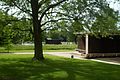
In addition to the spa gardens around the Glockensee, the Thie with its concert shell , where open-air concerts regularly take place in summer, is a main attraction for spa guests and visitors.
The local history museum is located in the former vicariate of St. Marien . On the Paulbrink you can find the statue of the linen weaver, which is reminiscent of the linen trade.
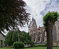
St. Marien with a former defense tower

St. Mary
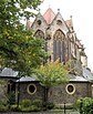
St. Marien, east side

The former pastorate of St. Marien with a cottage garden is used as a local museum

Catholic St. Antonius Church in the Remsede district

Half-timbered building in the center, built in 1768

The former water mill on the edge of the spa park

View from Blomberg into the spa park area at the Martinsquelle with the new graduation tower

The sculpture The Linen Dealer by Hans Gerd Ruwe at the former location of the Legge is a reminder of the history of linen production and trade


_im_Kurpark_Bad_Laer.jpg)

Regular events

- Kolping Carnival Revue in February
- Shooting festival of the Bad Laer Citizens' Rifle Club from 1543 on the third weekend in July
- Festival of 1000 torches on the first weekend in August
- Bourwinne on the first Wednesday in October
- Star taler market on the weekend of the 1st Advent
societies
- Bad Laer Citizens' Rifle Club from 1543
- Remsede Citizens' Rifle Club from 1875
- Hardensetten-Winkelsetten citizens' rifle club from 1953
- Citizens' shooting club Müschen from 1925
- Bad Laer music band
- Boys tent camp Bad Laer
- Girls' leisure time in Bad Laer
- Youth work group of the Catholic parish of St. Antonius Remsede (JAG)
- Sports club Bad Laer
- Sports club Remsede
- Sports club Westerwiede
- Homeland and mill association
- Spa and tourist association
- Kolping Bad Laer
- Catholic rural youth movement Bad Laer (Kljb)
Economy and Infrastructure

Companies
- B. Strautmann & Sons
- Sanicare mail order pharmacy
- Bad Laer health center
education
- Elementary school at Salzbach Bad Laer
- Geschwister-Scholl-Oberschule Bad Laer
- Elementary School Remsede (1959-2013)
traffic
In 1900 Laer was connected to the newly built "Teutoburg Forest Railway" (TWE). The route ran from the south of Gütersloh and Versmold to today's spa center and was extended in 1901 via Iburg, Lengerich and Tecklenburg to Ibbenbüren in the north. In 1968 the TWE stopped the passenger train service north of Versmold. In 2004 the station building, which was newly built in 1955, and in 2007 the old freight yard, were demolished. Houses with apartments for senior citizens were then built on the site.
In the summer months, the Teuto-Express ran a museum train that stopped in Bad Laer directly at the spa gardens. Up to 400 additional day tourists from the Tecklenburger, Münster and Osnabrück regions came to the health resort on driving days. Due to a line closure at Bad Iburg-Glane that has been in place since September 2011, Bad Laer can currently no longer be reached by the Teuto Express from Lengerich. In January 2012, the action alliance pro TWE was founded in Bad Laer , which has set itself the goal of long-term maintenance and regular use of the Teutoburg Forest Railway in the areas of leisure and tourism traffic. Since 2014, Bad Laer station has been the destination of special trains from Gütersloh and Bielefeld.

Kurpark with connection to the museum railway : The " Teuto-Express " locomotive ...
... V 36 412 passes the brine pavilion on the embankment at Glockensee.

The orange paint makes the Osning-Bahn rail bus ...

... to another splash of color in the middle of the adventure park of Bad Laer.


There is an hourly bus connection from the Verkehrsgemeinschaft Osnabrück from Bad Laer to Osnabrück and Bad Rothenfelde with regular intervals. There are also several bus connections from Bad Laer to Glandorf and Münster.
Bad Laer is connected to the trunk road network in an easterly direction via the state road 94 by the federal motorway A 33 .
Personalities
Sons and daughters of the church
- August Knemeyer (1928–2011), politician (CDU)
- Josef Meyer zu Schlochtern (* 1950), theologian
- Theo Paul (* 1953), Vicar General in the Diocese of Osnabrück
People connected to the community
- Heinrich Hiltermann (1911–1998), paleontologist, honorary citizen of the community
- Reinhard Keding (* 1948), former bishop in Namibia , has been pastor of the Evangelical Lutheran parish since 2005
See also
Web links
- Link catalog on the subject of Bad Laer at curlie.org (formerly DMOZ )
- Website of the municipality of Bad Laer
Individual evidence
- ↑ State Office for Statistics Lower Saxony, LSN-Online regional database, Table 12411: Update of the population, as of December 31, 2019 ( help ).
- ^ Roger Wilmans : The Imperial Charter of the Province of Westphalia: 777-1313 , 1867, p. 113 ff.
- ^ F. Jostes and W. Effmann: Pre-Christian antiquities in the Gaue Süderberge , 1888, p. 3. ( Digitalisat ULB Münster )
- ^ Heinrich Kampschulte: The Westphalian Church Patrocinia , 1867.
- ^ F. Jostes and W. Effmann: Pre-Christian antiquities in the Gaue Süderberge , 1888, p. 6 f.
- ↑ a b c d Federal Statistical Office (Hrsg.): Historical municipality register for the Federal Republic of Germany. Name, border and key number changes in municipalities, counties and administrative districts from May 27, 1970 to December 31, 1982 . W. Kohlhammer, Stuttgart / Mainz 1983, ISBN 3-17-003263-1 , p. 251 and 259 .
- ↑ Overview map of the Bad Laer Adventure Park
- ^ Jürgen Udolph (research): The "place name researcher". In: Website NDR 1 Lower Saxony . Archived from the original on December 28, 2014 ; accessed on August 3, 2019 .
- ↑ State Office for Statistics and Communication Technology Lower Saxony, population update ( page no longer available , search in web archives ) Info: The link was automatically marked as defective. Please check the link according to the instructions and then remove this notice.
- ↑ State Office for Statistics and Communication Technology Lower Saxony, Table 5000311
- ↑ Landkreis Osnabrück, official final results of the district election on September 9, 2001 ( Memento from May 25, 2005 in the Internet Archive ) (PDF; 528 kB)
- ^ The local elections for the district of Osnabrück on September 11, 2011 (also includes 2006 results). (PDF; 8 MB) Landkreis Osnabrück, p. 66, column “Municipal elections ” , accessed on March 6, 2016 .
- ↑ Quick report on the 2016 municipal elections in Bad Laer. Bad Laer municipality, September 11, 2016, accessed on October 21, 2018 .
- ↑ Announcement of the official final result of the mayoral election . Retrieved October 21, 2018.
- ↑ Franz Vollmer competes for BBL: home visit to Bad Laerer mayor candidate. Retrieved March 20, 2019 .
- ↑ https://www.noz.de/lokales/bad-laer/artikel/518640/stiller-abgang-von-bad-laers-burgermeister#gallery&0&0&518640 NOZ on October 30, 2014: "Silent departure of Bad Laers mayor"; accessed on March 26, 2018.
- ↑ https://www.noz.de/lokales/bad-laer/artikel/217847/august-knemeyer-im-alter-von-83-jahren-verstorben NOZ on October 7, 2011: "August Knemeyer at the age of 83 Years ago ”; accessed on March 26, 2018.
- ↑ Main statutes of the Bad Laer community ( memento from January 16, 2016 in the Internet Archive ), accessed on November 9, 2014.
- ↑ Rolf Westheider: With the Texas-Wackel-Express into the world - review of the 110-year history of the TWE Neue Osnabrücker Zeitung August 6, 2010.
- ↑ Global traffic in the Teutoburg Forest Neue Osnabrücker Zeitung March 16, 2012.
- ^ Teuto-Express: Track renovation required Neue Osnabrücker Zeitung September 22, 2011.
- ^ Bad Laer: Action alliance wants to save TWE Neue Westfälische Zeitung January 27, 2012.
Alfhausen | Ankum | Bad food | Bad Iburg | Bad Laer | Bad Rothenfelde | Badbergen | Belm | Mountains | Bersenbrück | Tapping | Bissendorf | Boiled | Bramsche | Dissen at the Teutoburg Forest | Eggermühlen | Fürstenau | Gehrde | Georgsmarienhütte | Glandorf | Hagen am Teutoburg Forest | Hasbergen | Hilter at the Teutoburg Forest | Kettenkamp | Melle | Menslage | Merzen | Neuenkirchen | Nortrup | Ostercappeln | Quakenbrück | Rieste | Voltage | Wallenhorst