Alfhausen
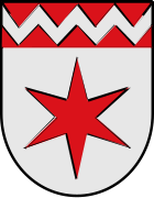
| coat of arms | Germany map | |
|---|---|---|
|
Coordinates: 52 ° 30 ' N , 7 ° 57' E |
|
| Basic data | ||
| State : | Lower Saxony | |
| County : | Osnabrück | |
| Joint municipality : | Bersenbrück | |
| Height : | 43 m above sea level NHN | |
| Area : | 39.33 km 2 | |
| Residents: | 4012 (Dec. 31, 2019) | |
| Population density : | 102 inhabitants per km 2 | |
| Postal code : | 49594 | |
| Area code : | 05464 | |
| License plate : | OS , BSB, MEL, WTL | |
| Community key : | 03 4 59 001 | |
| LOCODE : | DE AAY | |
| Community structure: | 4 districts | |
| Address of the municipal administration: |
Bremer Tor 8 49594 Alfhausen |
|
| Website : | ||
| Mayor : | Agnes Droste ( CDU ) | |
| Location of the community of Alfhausen in the district of Osnabrück | ||
Alfhausen is a member municipality of the joint municipality of Bersenbrück in the district of Osnabrück , Lower Saxony .
geography
location
Alfhausen is located about 27 km (as the crow flies ) north of Osnabrück between the southeastern foothills of the Ankumer Höhe in the west and the Alfsee in the southeast. Quick access is also provided by the Neuenkirchen-Vörden motorway junction of federal motorway 1 , which is only about 10 km away . Alfhausen is located directly on the federal highway 68 between Bersenbrück in the north and Bramsche / Hesepe in the south.
Flowing waters
Hase
The river Hase flows through the eastern areas of the municipality of Alfhausen. Here the hare is initially divided into the arms of the deep hare and the high hare . These arms of the rabbit have split up at the distribution structure in Bramsche-Sögeln and, after a few kilometers of the river, reunite at the eastern municipal boundary. Also on distribution structure in the branches feeders from the Alfsee, which after Alfsee as through conductors which Alfhausen-Rieste reserve pool passes and after leaving the reserve tank gets the name arrester. There, at the outlet of the reserve basin, the Ueffelner Aue river is also absorbed by the trap.
Ueffelner Aue
The Ueffelner Aue begins in Ueffeln between the Ankum mountains and the Gehn ridge. In the south of the community it acts as a border river between Alfhausen and Bramsche. At the three-house bridge of the feeder to the Alfsee the floodplain follows the Oldenburg – Osnabrück railway line to the northern edge of the Alfsee . After crossing under the railway line, it accompanies the dyke of the reserve basin up to the drain into which the Ueffelner Aue flows.
Nonnenbach
The resulting Bramsche Nonnenbach joins Heeke in the rabbit.
climate
| Alfhausen | ||||||||||||||||||||||||||||||||||||||||||||||||
|---|---|---|---|---|---|---|---|---|---|---|---|---|---|---|---|---|---|---|---|---|---|---|---|---|---|---|---|---|---|---|---|---|---|---|---|---|---|---|---|---|---|---|---|---|---|---|---|---|
| Climate diagram | ||||||||||||||||||||||||||||||||||||||||||||||||
| ||||||||||||||||||||||||||||||||||||||||||||||||
|
Average monthly temperatures and rainfall for Alfhausen
Source:
|
||||||||||||||||||||||||||||||||||||||||||||||||||||||||||||||||||||||||||||||||||||||||||||||||||||||||||||||||||||||||
Temperate maritime climate influenced by humid northwest winds from the North Sea. On a long-term average, the air temperature in Alfhausen reaches 8.5–9.0 ° C and around 800 mm of precipitation falls. Between May and August, an average of 20-25 summer days (climatological term for days on which the maximum temperature exceeds 25 ° C) can be expected. The precipitation is in the middle third of the values recorded in Germany. Lower values are registered at 51% of the measuring stations of the German Weather Service . The driest month is April, with the most rainfall in December. In June there is 1.6 times more rainfall than in February. The precipitation hardly varies and is very evenly distributed over the year. Lower seasonal fluctuations are recorded at only 7% of the measuring stations .
Weather station
A measuring station of the German Weather Service is located in Alfhausen . This station with the identification number 78 is located at an altitude of 65 meters above sea level and measures various weather parameters.
Extreme values
The highest temperature measured so far at the weather station was determined on the same day as the German temperature record at the Lingen weather station . On July 25, 2019, Hoch Yvonne set a temperature record of 39.2 ° C. The previous temperature record was set on August 19, 2012 with 36.8 ° C.
- Highest temperature measured so far on July 25, 2019: 39.2 ° C
- Lowest temperature measured so far on January 8, 1985: −25.2 ° C
Community structure
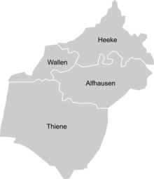
The community of Alfhausen consists of four districts
| District | Size in km² |
|---|---|
| Alfhausen | 8.28 |
| Heeke | 8.29 |
| Thiene | 19.25 |
| Ripples | 3.50 |
Land use
The 39.33 km² community of Alfhausen is divided into the following land uses (as of December 31, 2016) :
| Type of use | Area in km² |
|---|---|
| Total floor area | 39.33 |
| Settlement area | 2.54 |
| traffic area | 2.18 |
| Agriculture | 25.63 |
| Forest | 5.77 |
| Unland | 0.08 |
| Body of water | 2.82 |
Neighboring communities
Alfhausen borders on Ankum to the northwest , the city of Bersenbrück to the north and Rieste to the east . Like Alfhausen, these places are also members of the Bersenbrück community . To the south is the Bramsch district of Hesepe, to the west the localities of Ueffeln and Balkum, which also belong to Bramsche .
|
Ankum 7 km |
Bersenbrück 6 km |
|

|
Rieste 5 km |
|
|
Bramsche 10 km |
history
The large stone grave of Wallen , which was destroyed in the 19th century and was also called the pagan altar , testifies to the settlement of the local area during the Neolithic Age . With the large stone grave Woltrup-Wehbergen there was another large stone grave in the border area to Bersenbrück, this large stone grave was also destroyed in the 19th century. The well-fortified parish village of Alfhausen "in the legendary Giersfeld , at the foot of the Heiligenberg " ( 104.3 m ) was first mentioned in 977 in a certificate from Emperor Otto II dated October 29, 977 as Alfhuson .
Great storm of 1703
During the great storm of 1703 the spire of the church was knocked down on December 8th. The spire fell on the nave and partially penetrated the vault, so that the high altar was also affected. The reconstruction of the tower and the repair of the church required great efforts on the part of the community.
1770 earthquake
On September 3, 1770, the place was hit by an earthquake that was very strong by north German standards. The first scientific mention was made in 1940 by August Heinrich Sieberg . An estimate of the maximum intensity was carried out in 1970 by Ludwig Ahorner with a VII on the Medvedev-Sponheuer-Kárník scale . This earthquake is the strongest that has become known in northern Germany so far.
Village fire in 1775
In 1775 on October 19, a large village fire occurred in Alfhausen, in which several houses and granaries were destroyed by flames. A woman also died in the flames. So five granaries of the Kirchhöfnerei are said to have burned down, which gave the Kirchhöfnerei its current appearance.
Port of operation in Hesepe
During World War II the then independent district in Thiene was to the neighboring village in the border area Hesepe the insert port "Holsten" Hesepe the Luftwaffe settled. Construction of the three runways began in 1938. After the war, the area was partly reforested or used for agriculture.
End of the war in 1945
After the town of Bramsche fell to the advancing British forces without a fight on the morning of April 10, they pushed on towards Alfhausen. South of the outskirts, the advance of the 5th Highland Light Infantry and the 52nd Reconnaissance Regiment was stopped by German officer candidates of the Poeschmann Regiment (reserve of the Greater Germany Division ). Several houses were set on fire as a result of the tank fire of the accompanying 4th Armored Brigade. Numerous houses were destroyed, especially in the Rüllenhook. The church tower caught fire and was extinguished by the fire brigade and British soldiers.
Wallen was occupied without a fight on the same day, Heeke the following day.
Incorporations
On February 1, 1971, the communities of Heeke , Thiene and Wallen were incorporated.
Severe weather disaster on 16./17. August 1974
On the night of August 16-17, 1974, Alfhausen and the neighboring communities were hit by an eight-hour continuous thunderstorm. Hailstones up to the size of billiard balls fell and caused millions of euros in damage.
Population development
The following overview shows the population of Alfhausen in the respective territories and on December 31st.
The figures are updates by the State Office for Statistics and Communication Technology Lower Saxony based on the census of May 25, 1987 .
The information on 1885, 1925, 1933 and 1939 refer only to the municipality of Alfhausen without later incorporations.
The data from the years 1961 (June 6) and 1970 (May 27) are the census results including the places that were incorporated on February 1, 1971.
|
|
|
|
|
Name interpretation
The old Saxon place name Alfhuson is probably derived from one of the numerous first names beginning with "Alf" (there was also a short name Alf). Alfhausen would therefore mean: The house in which Alf lives. It can be assumed that the place was named after the main courtyard in the area, which once belonged to an Alf. The assumption that Alf in Low German means the number 11 and the place name thus "Elf Houses" is untenable from a local perspective.
The Alkensage
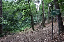
In ancient times there were only twelve houses where the village of Alfhausen is now, whose residents had to go to the church in Merzen. One of the houses was far away in the heather near the old barrows on the Giersfeld. It was called “the mug” because the church people used to relax from their long journey with a mug of beer. The landlord - his name was Alke - thought more of his merit than of God. He made people drink and always said they'd be early enough for mass. So they rarely came at the right time. God's judgment finally met him. When he had church people with him again, he cursed that his house should sink into the ground if they didn't have enough time. Then his house and farm sank, and he with them.
In their place there were two deep hollows, the "Alkenkrug". The people, however, called the remaining eleven houses Alfhausen, as if they wanted to exclude what had gone under from their community forever and built their own church. But at the point where the landlord and his house went down, Alke is still up to now at night. If someone walks around the Alkenkrug three times and calls Alke by his name, then it comes as a fiery wheel and pulls him with him into the abyss.
When the farmer Grumfeld was once sitting with a number of friends over a beer and they came up with the question of who had the best and fastest horse, Grumfeld conspired in thunder, weather and severe hardship that he wanted to go to the Alkenkrug on his gray horse the next night ride and challenge Alke to a competition. The others took him at his word and bet nine pounds of silver that he couldn't do it. He accepted the bet and got ready to ride. He cleaned his horse, led it to the alkene jar and showed it what to do during the night. The clever beast understood everything and came back with his master at a quick run. He shows him that he wanted to leave the big gate open at night and gave him the best he had to eat. Above all, however, he prayed three times in holy devotion to the Father, Son and Holy Spirit that they would forgive him of his sins, keep his soul and save him from danger.
So came midnight; Grumfeld rode to the Alken Hollow, hard to its edge. It was a quiet, starry night. No sound, not even a fox or an owl, could be heard. The white horse stood and did not move a limb. Grumfeld prays quietly to himself. Then he heard the twelfth hour strike, first from Ueffeln, then from Merzen and finally from Alfhausen. At the last blow he called out in a loud voice: “Alke, kumm! Will you take part? ”A voice in grave clay answers:“ Töf! I want to touch the one Schoh, move on to the men, then I want to get the Düwel! "
At the same moment the farmer gave his horse the spurs, and the animal ran furiously towards the farm, Alke following behind as a fiery wheel. The fiery monster came closer and closer. Then the white horse sat over the door on the hall, just at the moment when it was about to grab the rider.
Grumfeld was saved and had won his bet, but lost his horse. It had collapsed dead. At the hearth, Grumfeld thanked his Lord God and vowed not to try again.
The next morning you saw the symbol of the glowing wheel on the door post: it was charred black.
Religions
The majority of the population is Roman Catholic . However, there are also other religious communities in the place.
politics
Municipal council
The parish council currently has 15 members from four parties or groups. Mayor is Agnes Droste (CDU). The following table shows the local election results since 1996.
| Council of the community of Alfhausen: election results and community councils | |||||||||||||
|---|---|---|---|---|---|---|---|---|---|---|---|---|---|
| CDU | SPD | GREEN | FDP | BLA 1 | total | electoral participation |
|||||||
| Electoral term | % |
|
% |
|
% |
|
% |
|
% |
|
% |
|
% |
| 1996-2001 | 59.2 | 9 | 10.6 | 1 | 2.7 | 0 | - | - | 27.5 | 5 | 100 | 15th | 78.4 |
| 2001-2006 | 52.7 | 8th | 8.2 | 1 | 1.0 | 0 | - | - | 38.0 | 6th | 100 | 15th | 68.0 |
| 2006-2011 | 62.8 | 10 | 7.7 | 1 | 1.8 | 0 | 2.1 | 0 | 25.6 | 4th | 100 | 15th | 54.1 |
| 2011-2016 | 59.55 | 9 | 10.86 | 2 | 4.48 | 1 | 1.07 | 0 | 24.02 | 3 | 100 | 15th | 53.5 |
| 2016-2021 | 63.04 | 9 | 14.95 | 2 | 3.53 | 1 | - | - | 18.47 | 3 | 100 | 15th | 54.6 |
| Percentages rounded. Sources: State Office for Statistics and Communication Technology Lower Saxony, District of Osnabrück. The data from the State Office for Statistics and Communication Technology were used in the case of different information in the sources mentioned, as they are generally more plausible.
1 Alfhausen citizens' list
|
|||||||||||||
Mayoress
- Agnes Droste (CDU) since 2016
Former mayor
- 2001–2016 Klaus Wübbolding (CDU)
- 1981–2001 Karl-Heinz Bittner (CDU)
- 1976–1981 Heinz Göbel (CDU)
- 1971–1976 Georg Schmidt (CDU)
Former mayor of the old community of Alfhausen
Mayor of the old community of Alfhausen until the municipal reform in 1971.
- 1969–1971 Heinz Göbel (CDU)
Community partnerships
-
 La Meignanne ( France ), since 2002
The partnership between Alfhausen and La Meignanne developed from 1998 on the initiative of the French town which was looking for a partner municipality in the greater Osnabrück area. Osnabrück had a partnership with the city of Angers , in whose arrondissement La Meignanne is located, since 1964 . After making the first contacts, the partnership certificate was exchanged in 2002 during the 1025th anniversary of Alfhausen.
On January 1, 2016, La Meignanne was merged with La Membrolle-sur-Longuenée , Le Plessis-Macé and Pruillé to form a nouvelle commune called Longuenée-en-Anjou , but this does not change the partnership.
Culture and sights
music
Alfhausen is the birthplace of numerous music groups, including the Groovin 'Goblins .
Buildings
Parish Church of St. Johannis
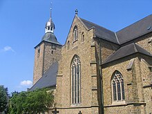
The Roman Catholic parish church of St. Johannis from the 13th century is one of the main attractions of the place, with its furnishings from partly Gothic times, such as B. the Bentheim baptismal font or the Radiant Madonna from 1517.
see also:
Cemetery
To the south of the parish church of St. Johannis, several old half-timbered houses are grouped around the edge of the old cemetery. These houses, initially laid out as storage facilities, are still inhabited today.
Alfsee
The Alfsee flood retention basin is the most famous structure in the Alfhausen community. Due to the location of the lake in the municipality, the name Alfsee quickly became naturalized. This reservoir , which was built in 1971, is intended to prevent flooding in the lower reaches of the Hase . Before the dams were completed in 1981/82, Quakenbrück, Haselünne and Meppen in particular were at risk of being inundated by minor floods.
The Alfsee was later supplemented by the reserve basin completed in 1996, which is a dry flood retention basin. If the storage volume of the Alfsee is exhausted, the reserve basin can be flooded and thus provide additional storage space. The inner basin area is a nature reserve and may not be entered, but a circular path is laid out on the top of the dike which allows a good view of the areas in the basin.
Extreme hare floods like those in spring 1981, October 1998 and August 2010 could be buffered in this way.
As a popular destination for vacationers and day trippers, the lake has gained in importance in recent years. A holiday complex was laid out on the east bank as early as the construction phase of the lake. This was expanded and expanded more and more in the following years. In addition to the well-known water ski facility , there are numerous other attractions. Unlike the Alfsee and the reserve basin, which are mostly located in the Alfhauser municipality, the holiday complexes are mainly located in the Rieste area .
see also:
Heeker Klause
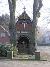
In the center of the district of Heeke is the Heeker Klause (built in 1818), which was renovated and inaugurated in 1970. The hermitage is still used today for May services and the annual supplication.
see also:
Natural monuments
Various Stone Age graves can be viewed in the border area to Ankum in Giersfeld.
Sports
Various sports are offered in the municipality: soccer, judo, cycling, volleyball, shooting, horse riding, fishing and, for some years, darts.
Public facilities
Educational institutions
A first school in Alfhausen is mentioned in a visit report in 1655. Since the old school chronicle fell victim to the fighting in 1945, no older evidence can be provided.
The first school on Alte Schulstrasse was built in 1841 and expanded in 1875/76. In 1913, the old school, which from 1965 housed the fire brigade and the community office, was moved into. The schools at Bahnhofsesch were rebuilt from 1965.
In 1992 the Riester secondary school was closed and the Riester secondary school students were taught in Alfhausen. Due to the falling number of pupils at the secondary schools, the Alfhausen secondary school, the Alfseeschule, was closed in the summer of 2013 . Since then, only the primary school has remained on site.
Former schools
- Alfhausen secondary school (–2013)
- Heeker School (1820–1969)
- Thien School (1860–1972)
- Rector's School (1916–1936)
- agricultural vocational school (1917–1964)
fire Department
The Alfhausen Volunteer Fire Brigade was founded in 1896. In addition to the normal tasks of a fire brigade, a water rescue and diving group is held in Alfhausen .
Infrastructure / traffic
railroad
After the construction of the Oldenburg – Osnabrück railway was completed on June 30, 1876, the first test train for route approval reached Alfhausen on the same day. The official opening of the railway line took place on October 15, 1876. The station at route kilometer 82.28 consisted of two main and two loading tracks that could be reached via five points.
When the NordWestBahn took over local passenger transport on the line on November 5, 2000, Alfhausen station is no longer served by passenger trains. The reason for the cancellation of the stop was the compliance with a journey time of 90 minutes between Osnabrück and Oldenburg.
After numerous requests for reactivation, the Alfhausen station was added to the list of train stops to be reactivated in 2015 by the Lower Saxony state government . After the necessary technical changes have been made to the railway line, local passenger trains will stop here again.
The next train stations are Bersenbrück in the north (connection with the RE 18 to Oldenburg and Wilhelmshaven), Bramsche (RE 18 and RB 58 in the direction of Osnabrück) and Bramsche-Hesepe (RB 58 Osnabrück – Vechta – Bremen) in the south. The stop in Rieste on the Delmenhorst – Hesepe railway line (RB 58) is around 6 km away.
Street
The federal road 68, which is one of the main connecting routes between Osnabrück and Oldenburg, runs through the town center . Through the nearby A 1 - Hansalinie - exit Osnabrück-Nord, Neuenkirchen-Vörden or Holdorf Alfhausen can be reached by car. There are bus connections from the Verkehrsgemeinschaft Osnabrück from Alfhausen to Rieste and Bersenbrück.
Others
Due to the popularity of the television character Alf , the town signs of Alfhausen were often stolen during the 1980s and 1990s.
Personalities
- Hermann Auf der Heide ( 1932 - March 14, 2003 ), sculptor
- Susanne Tunn (* 1958 in Detmold ), sculptor, had her studio in the station building of Alfhausen from 1991 to 2014.
Web links
literature
in chronological ascending order
- Helmut Niedernostheide, Franz Huchkemper: Church leader parish church St. Johannis Alfhausen. Catholic parish of St. Johannis Alfhausen (no date).
- Klaus Starmann: story (s) from the parish Alfhausen . Alfhausen 2012, ISBN 978-3-8442-3180-9 .
- Renate Bohmann, Hans Steinkamp: Festschrift for the 75th anniversary of the settlement of the Schleppenburg. Alfhausen 2003.
- Helmut Niedernosterheide, Bernhard Wellmann: Alfhausen 1025 years, a chronicle in words and pictures . Alfhausen 2002, ISBN 3-9807102-5-4 .
- Günter Wegmann: The end of the war between Ems and Weser 1945. 2nd expanded edition, H. Th. Wenner, Osnabrück 2000, ISBN 3-87898-367-0 .
- Clemens Wellbrock, Alfhausen fire brigade: 100 years of Alfhausen volunteer fire brigade. Alfhausen 1996.
- Working group photo book Heimatverein Alfhausen: Alfhausen. A chronicle in pictures. Alfhausen 1979, self-published by the municipality of Alfhausen.
- Otto zu Hoene, Robert Meyer: 1000 years of Alfhausen 977–1977. Contributions to the historical development of the church game. Alfhausen 1977, self-published by the municipality of Alfhausen.
Individual evidence
- ↑ State Office for Statistics Lower Saxony, LSN-Online regional database, Table 12411: Update of the population, as of December 31, 2019 ( help ).
- ^ The climate in Alfhausen 1961–2019. In: wetterzentrale.de. Retrieved October 3, 2019 .
- ↑ Station Atlas of the German Weather Service; Alfhausen station.
- ↑ Website wetterzentrale.de with the top 10 table of the Alfhausen weather station
- ↑ Decade records (maximum temperature, minimum temperature) at around 1000 German stations
- ^ Alfhausen 1025 years. A chronicle in words and pictures. P. 11.
- ↑ Information on cadastral area according to types of use from the Lower Saxony State Statistics Office
- ↑ Helmut Niedernostheide, Franz Huchkemper: Church guide parish church St. Johannis Alfhausen. Catholic parish of St. Johannis Alfhausen, p. 3.
- ↑ fzpublic.gfz-potsdam.de/pubman/item/escidoc:230168:1/component/escidoc:230167/4400.pdf Investigation of the earthquake of 1770
- ^ Clemens Wellbrock, Alfhausen fire department: 100 years of Alfhausen volunteer fire department. Alfhausen 1996, p. 21.
- ^ Günter Wegmann: The end of the war between Ems and Weser 1945. 2nd expanded edition, p. 191.
- ↑ a b Federal Statistical Office (ed.): Historical municipality register for the Federal Republic of Germany. Name, border and key number changes in municipalities, counties and administrative districts from May 27, 1970 to December 31, 1982 . W. Kohlhammer GmbH, Stuttgart / Mainz 1983, ISBN 3-17-003263-1 , p. 253 .
- ↑ Internet presence of the joint community BSB: Population figures June 2016
- ↑ State Office for Statistics and Communication Technology Lower Saxony, population update ( page no longer available , search in web archives ) Info: The link was automatically marked as defective. Please check the link according to the instructions and then remove this notice.
- ↑ Michael Rademacher: German administrative history from the unification of the empire in 1871 to the reunification in 1990. Data for 1885, 1925, 1933 and 1939. (Online material for the dissertation, Osnabrück 2006).
- ^ Wilhelm Fangmeyer: Interpretation of place names in the Osnabrück region. In: Heimat-Jahrbuch Osnabrücker Land. 1982, p. 78.
- ↑ State Office for Statistics and Communication Technology Lower Saxony, Table 5000311
- ↑ Landkreis Osnabrück, official final results of the district election on September 9, 2001 ( Memento from May 25, 2005 in the Internet Archive ) (PDF; 528 kB)
- ^ The local elections for the district of Osnabrück on September 11, 2011 (also includes 2006 results). (PDF 8.0 MB; p. 29, column “Municipal elections ”) Osnabrück district, accessed on March 6, 2016 .
- ^ The local elections for the district of Osnabrück on September 11, 2016. (PDF 16.3 MB; p. 27, column “ Local elections ”) District of Osnabrück, accessed on October 13, 2016 .
- ^ Article of the NOZ about Karl-Heinz Bittner
- ↑ Bersenbrücker Kreisblatt on June 17, 2009: Obituary by the Alfhausen community on the death of Heinz Göbel
- ↑ NOZ on June 25, 2009: Mourning for Heinz Göbel, accessed on April 4, 2018
- ↑ NOZ on May 10, 2012: The contacts are increasing, accessed on April 4, 2018
- ↑ 1000 years of Alfhausen 977–1977. Contributions to the historical development of the church game. P. 93.
- ↑ NOZ on June 22, 2013: Alfhausen's last bullies, accessed on April 27, 2018
- ↑ www.feuerwehr-alfhausen.de. Retrieved July 26, 2020 .
- ↑ Suspension of passenger traffic according to Pro Bahn
- ↑ NOZ on May 19, 2015: Will the Alfhausen train stop arrive by 2020/21? accessed on June 22, 2018


