
Glandorf
| coat of arms | Germany map | |
|---|---|---|

|
Coordinates: 52 ° 5 ' N , 8 ° 0' E |
|
| Basic data | ||
| State : | Lower Saxony | |
| County : | Osnabrück | |
| Height : | 68 m above sea level NHN | |
| Area : | 59.88 km 2 | |
| Residents: | 6592 (Dec. 31, 2019) | |
| Population density : | 110 inhabitants per km 2 | |
| Postal code : | 49219 | |
| Area code : | 05426 | |
| License plate : | OS , BSB, MEL, WTL | |
| Community key : | 03 4 59 034 | |
| LOCODE : | DE GDX | |
| Community structure: | 7 districts | |
| Address of the municipal administration: |
Munsterstrasse 11 49219 Glandorf |
|
| Website : | ||
| Mayoress : | Magdalene Heuvelmann | |
| Location of the community of Glandorf in the district of Osnabrück | ||
  |
||

Glandorf is a municipality in the southwest of the Osnabrück district in Lower Saxony . The name comes from the name Glanathorpe - settlement on the Glane - and was first mentioned in a document in 1070.
geography
location
Glandorf is located in the northern edge of the Westphalian Bay a few kilometers south of the Teutoburg Forest on the Glaner Bach .
Neighboring communities
Glandorf borders Bad Iburg and Bad Laer in the east . The other neighboring communities belong to North Rhine-Westphalia : Lienen in the north ( Steinfurt district ), Ostbevern in the west and Warendorf and Sassenberg (all Warendorf district ) in the south .
Community structure
The municipality of Glandorf consists of the following localities:
|
|
history
The name Glandorf is probably of Celtic origin, because Glane probably means "bright, clear, shiny, flowing"; in addition, "Glan" was part of the name of the Celtic water god Glanus or Glanos. Around the 6th century BC, the Celts were expelled by the Germans , who then settled the area. The name researcher Hermann Jellinghaus takes a different view .
“No part of old Germany between the Rhine and Elbe, i.e. precisely the area in which Celtic and Slavic place names have not yet been identified, has so many village names that defy reliable interpretation as the area of the Ems and its tributaries. … Glandorf: Glanathorpe 1070. From the Glane stream flowing into the Ems. The word has been declared Celtic. But then it would not be so common: Glane near Wildeshausen and Gronau, Glanhorst, Kr. Minden, Glanemeier near Barkhausen , Kr. Wittlage , the Glenne , Kr. Lippstadt, the Glenbach im Deister . "
Especially the frequency of the word "Glane": such as B. Glaner Braut , Glanerbeek he considers to be evidence of Germanic origin; an adjective “glan” means shiny, blinking, the associated verb is glennen-glanzen or gliman-glan-glunum. In 1872 an old Germanic burial ground, individual urns with remains of bones and burns, was excavated on the Donnerbrink. In the Middle Ages , Glandorf, like its neighboring communities Bad Iburg , Bad Laer , Glane and Remsede, belonged to the Gau Sutherberge or Suderberggau or Gau Süderberge, whose name is derived from the location south of the Osning (Teutoburg Forest). The area was first mentioned in a document from Ludwig the German dated December 8, 851, in which several farms in Laer and Erpen , named Arpingi in the document, were given to the Marienkloster in Herford : “[…] in pago, quod dictur Sutherbergi, in villa quae nuncupatur Lodre […] et in eodem pago, in villa quae vocatur Arpingi. “Lodre is today's Bad Laer, which was still written Loder or Loer into the 17th century. Glandorf was a branch of the mother parish in Laer until 1200, but by 1400 it already had a second clergyman. When the separation from Laer took place cannot be seen from the documents of the parish archives.
The name Glandorf or Glanathorpe was first mentioned in a document in 1070. According to an article in a supplement in the "Osnabrücker Volkszeitung" on August 4, 1889, the document states that the owner of the Helfer Hof in Lienen had the right to drive thirty pigs and one boar to be acorn-fed in the Glandorfer Mark.
After the Battle of Breitenfeld in 1631 , the Swedish troops occupied the Diocese of Osnabrück in the Thirty Years' War . After the Glandorf population could no longer meet the demands of the Swedish mercenaries, they set the village on fire on May 5, 1636. The event indicates an inscription carved in stone above the bride door in the church of St. Johannis . Some atrocities are said to have occurred before the fire. In the homeland novella "Schwedenchronik" from 1926, the clerical councilor Bernhard Köster said that the Swedish mercenaries crucified a daughter in the courtyard of the mayor at that time, Schultewerth, and smothered another over the hearth, and that the mayor himself gave the Swedish drink.
As part of the Diocese of Osnabrück Glandorf was 1803 after the Reichsdeputationshauptschluss of King George III. slammed into the Electorate of Hanover . However, the electorate was occupied by French troops in the same year and in 1807 merged with the Kingdom of Westphalia created by Napoléon . The parish of Glandorf was now called Commune or Mairie Glandorf and belonged to the canton Ostbevern, which was subordinate to the Arrondissement Warendorf. After the collapse of the French empire, Glandorf fell to the Kingdom of Hanover in 1814 .
In 1833, emigration to North America began. The Osnabrück clergyman, high school teacher and Glandorf native Johann Wilhelm Horstmann embarked in September of that year with six other Glandorf men in the Osnabrück office of Iburg in Amsterdam, acquired land in Putnam County in December and founded the town of Glandorf (Ohio) . The wives and ten other families followed the group in 1834 and in 1835 nine more families from Glandorf joined them. The wave of emigration did not end there; it lasted until the beginning of the 20th century.
On July 1, 1972, the communities of Averfehrden, Glandorf, Remsede, Schierloh, Schwege, Sudendorf and Westendorf were incorporated into the community of Laer (from September 1, 1975 Bad Laer ). On May 1, 1981, the community of Glandorf was spun off. With the exception of Remsede, all the places that were incorporated into Laer at that time came to the municipality of Glandorf.
Population development

The following overview shows the population of the municipality of Glandorf in each area and on December 31st.
The numbers are updates by the State Office for Statistics and Communication Technology Lower Saxony based on the census of May 9, 2011 .
The data from 1961 (June 6th) and 1970 (May 27th) are the census results including the places that belong to Glandorf since May 1st, 1981.
| year | 1961 | 1970 | 1987 | 1990 | 1995 | 2000 | 2005 | 2010 | 2015 | 2017 | 2018 |
| Residents | 4844 | 5077 | 5441 | 5686 | 6451 | 6706 | 6821 | 6724 | 6664 | 6665 | 6616 |
Religions
Glandorf is traditionally a Catholic community. The religious affiliation of the taxpayers is divided between approx. 400 Protestant and approx. 2900 Catholic. Around 280 residents are considered to be non-denominational.
politics
Municipal council
The parish council currently has 18 members from three parties or groups. The mayor is also the chairwoman of the council with voting rights.
The following table shows the local election results since 1996.
| Council of the municipality of Glandorf: election results and municipal councils | |||||||||||||||||||
|---|---|---|---|---|---|---|---|---|---|---|---|---|---|---|---|---|---|---|---|
| CDU | SPD | GREEN | UWG | total | electoral participation |
||||||||||||||
| Electoral term | % |
|
% |
|
% |
|
% |
|
% |
|
% | ||||||||
| 1996-2001 | 70.1 | 14th | 15.0 | 3 | 2.3 | 0 | 12.6 | 2 | 100 | 19th | 75.4 | ||||||||
| 2001-2006 | 72.2 | 14th | 15.8 | 3 | 2.4 | 0 | 9.7 | 2 | 100 | 19th | 69.4 | ||||||||
| 2006-2011 | 63.2 | 12 | 22.8 | 4th | 1.3 | 0 | 12.7 | 2 | 100 | 18th | 70.1 | ||||||||
| 2011-2016 | 55.11 | 10 | 16.48 | 3 | 2.46 | 0 | 25.95 | 5 | 100 | 18th | 63.56 | ||||||||
| 2016-2021 | 47.1 | 9 | 17.2 | 3 | - | - | 35.7 | 6th | 100 | 18th | 64.74 | ||||||||
|
Percentages rounded. Sources: State Office for Statistics and Communication Technology Lower Saxony, District Osnabrück. In the case of different information in the sources mentioned, the data from the State Office for Statistics and Communication Technology were used, as they are generally more plausible. |
|||||||||||||||||||
coat of arms
The coat of arms of the municipality of Glandorf has the shape of a shield in the colors silver and red. The Diocese of Osnabrück , to which Glandorf has belonged for centuries, uses the same colors . In the upper part of the coat of arms there is a red cross on a silver background, which is based on the church flag and represents an attribute of John the Baptist, the namesake of the Catholic Church in Glandorf.
In the lower part of the shield half you can see a silver-colored branch from which three leaves, a linden, an oak and a shamrock sprout in a fan shape. One branch should be a symbol for the fact that people of very different kinds also live together, get along fraternally and form a whole.
Community partnerships
- Glandorf (Ohio) , USA
- Lichtenberg in the municipality of Feldberger Seenlandschaft in the Mecklenburg Lake District in Mecklenburg-Western Pomerania
Urban structure
The center of the place is the Thieplatz. In the past, this is where the village's open well was located. In October 2010 the fountain redesigned by the artist Elisabeth Lumme was inaugurated above the 100 year old cistern under Thieplatz. The historical building fabric was largely preserved during the redesign. However, not all Glandorf residents agreed to the renovation of the historic water reservoir. The almost completely preserved churchyard castle borders the Thie, in the vicinity of which there are several old half-timbered houses.
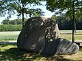
The largest boulder in the Osnabrück area is set up on the B 475 in the Averfehrden district . The originally connected stone was found approx. 300 m northeast of the place of installation. A few years after the stone was moved to its current location, a wedge-shaped fragment called David came loose while the great remainder is called Goliath .
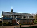
Churches
In the center of Glandorf is the Catholic parish church of St. Johannis , which was first mentioned in a document in 1275. The oldest parts of the Kirchhofsburg also date from this time. There was probably an older church elsewhere. According to the unprinted history of Glandorf's manuscript by Bernhard Köster on the original site, one possible location could have been in Westendorf.
Another Catholic church, the parish church of St. Marien, is in the Schwege district. It was built on the initiative of the teacher Mathias Niehaus, who, after taking a vow, laid out a calvary with a Way of the Cross, an olive garden and Christ's tomb. In 1863 the first chapel with a matching small tower was built on this site. Mathias Niehaus died in the same year, but his work was continued. In 1865 the Vicariate House followed and in 1866 the church was expanded without permission. Only the small tower, of which it was jokingly claimed that it would be pulled under the church roof when it rained, was only replaced by a larger tower after the First World War.
The Evangelical Lutheran Church Kripplein Christi is located in Glandorf near the Theresien-Haus. Originally it was designed by Karl Siebold from Bethel near Bielefeld as an emergency church to serve as a temporary measure for a community. It should be portable and easy to assemble and dismantle. Their lifespan was originally set at 30 to 40 years. The wooden church was first built in 1912 in Holsen-Ahle near Bünde . After almost 40 years, the dilapidated building there was supposed to be demolished, but instead it was bought by the Protestant community in 1952 and rebuilt in Glandorf on a stone foundation. The rotten wood had to be removed and the church shortened by two longitudinal segments from 450 to 300 seats.
Buildings
A gallery windmill of the Dutch design is Glandorf's landmark. It was commissioned in 1840 and was in service until 1960. The interior of the mill has been used as a registry office room since 2000.
The Theresien-Haus is the former hospital and was called Theresien-Hospital at the time. Today there is a Caritas facility for people with chronic addictions in the building.
Another attraction is the Merschmühle, which is over 750 years old and belongs to the Dallmöller family. Its water and damming rights, which are still valid today, date from around 1235. The water mill was modernized in 1989 and today supplies environmentally friendly electricity from hydropower. The water for this is supplied by the Glaner and Remseder Bach.
The weir store on the Högemann farm is also worth seeing. The building, which was formerly surrounded by a moat, consists of a massive base storey, which is a fragment of a stone work from the 14th or 15th century. The two-storey building resting on it (two later plastered half-timbered floors, faced with square hand-streaked bricks on the weather side) with a protruding roof on simple grooved lugs, was probably built in the first half of the 16th century, according to Eyinck.On the other hand, Schepers with the probably inaccurate archival dating of the half-timbered floors the year 1768.
photos

St. Johannis

Portal of St. Johannis

St. Johannis Church (aerial photo, 2014)
Kripplein Christi -
Evangelical Lutheran. church
St. Marien in Schwege

Windmill as a landmark

Former Theresien Hospital
David and Goliath, the largest boulder in the Osnabrück area


Leisure and sports infrastructure
The municipality of Glandorf is connected to the regional cycle path network via various routes. However, the most ambitious leisure offer in the municipality is the municipal indoor garden swimming pool with its weather-independent offer. The sports club SC Glandorf e. V. has 13 departments, 3 sports fields and 2 sports halls for games and training. The farmer who lives there operates a combined disc and swing golf course on the Dinkelhof .
Economy and Transport
Despite its commercial and industrial operations, Glandorf has retained a rural, peasant character.
The federal highways 475 (west-east direction) and 51 (north-south direction) cross in the Glandorf district.
There is an hourly regular service from the Osnabrück Transport Association from Glandorf to Osnabrück. There are also bus connections from Glandorf to Bad Rothenfelde , Warendorf, Ostbevern and Münster.
Sons and daughters of the church
- Franz Jostes (1858–1925), German and linguist
- Wilhelm Erpenbeck (1892–1971), politician ( center , CDU )
- Franz Konrad Ossege (1895–1982), local poet
- Helmut Kortmann (* 1947), vascular surgeon in Munich and Hamburg
- Hermann-Josef Große Kracht (* 1962), Catholic theologian
- August Raske , federal judge (1901–1994)
literature
- Bernhard Schmitz: History of Glandorf. New edition of the book published by Bernhard Schmitz in 1904. Glandorf 2000, ISBN 3-8311-1254-1 .
- Maria Brüggemann, Klaus Pusch: 750 years of Schwege . Krimphoff, Sassenberg 1985.
- Anne Aengenvoort: Migration, settlement formation, acculturation: the emigration of Northwest Germans to Ohio 1830–1914 . Steiner, Stuttgart 1999, ISBN 3-515-07423-6 . P. 118.
Web links
Individual evidence
- ↑ State Office for Statistics Lower Saxony, LSN-Online regional database, Table 12411: Update of the population, as of December 31, 2019 ( help ).
- ↑ Illustration of the Kärntner Glan
- ↑ Hermann Jelinghaus: Village name to Osnabrück, Osnabrück 1922, p.3 u. P. 15
- ^ "Glane, Kr. Iburg, originally part of Bisbeck: Glana, Glano 1088 Glandorf: Glanathorpe 1070. From the Glane stream flowing into the Ems. The word has been declared Celtic. But then it wouldn't be so common: Glane near Wildeshausen and near Gronau, Glanhorst, Kr Minden, Glanemeier near Barkhausen, Kr Mittlage, the Glenne, Kr Lippstadt, the Glenbach im Deister. From an adjective glan, shining, looking. Cf. Doornkaat 1, 634 under glennen, glossy, to a verb * glinangglan-glunum. ”See Hermann Jelinghaus: Dorfnames um Osnabrück, Osnabrück 1922, p. 15
- ↑ Roger Wilmans : The Imperial Documents of the Province of Westphalia: 777-1313 , 1867, p. 113f.
- ^ F. Jostes and W. Effmann: Pre-Christian antiquities in the Gaue Süderberge , 1888, p. 3
- ↑ a b Federal Statistical Office (ed.): Historical municipality register for the Federal Republic of Germany. Name, border and key number changes in municipalities, counties and administrative districts from May 27, 1970 to December 31, 1982 . W. Kohlhammer GmbH, Stuttgart and Mainz 1983, ISBN 3-17-003263-1 , p. 251 and 259 .
- ↑ State Office for Statistics and Communication Technology Lower Saxony, population update ( page no longer available , search in web archives ) Info: The link was automatically marked as defective. Please check the link according to the instructions and then remove this notice.
- ↑ State Office for Statistics and Communication Technology Lower Saxony (LSKN)
- ↑ State Office for Statistics and Communication Technology Lower Saxony, Table 5000311
- ^ Official final results of the district election on September 9, 2001 ( Memento from May 25, 2005 in the Internet Archive ; PDF; 528 kB) Osnabrück district
- ^ The local elections for the district of Osnabrück on September 11, 2011 (also includes 2006 results). (PDF; 8.0 MB) Landkreis Osnabrück, p. 69, column “Municipal elections ” , accessed on March 6, 2016 .
- ↑ Anke Schneider: A piece of jewelery in the heart of Glandorf . In: Neue Osnabrücker Zeitung , October 25, 2010; accessed on October 14, 2015.
- ^ Josef Schepers: House and farm of German farmers. Westphalia lip . Münster 1960, p. 101 .
- ↑ Alfons Eggert, Josef Schepers: Spieker, "Bauernburgen", Kemenaden. Rural storage buildings in the Münsterland. Your construction, functional and social history in a European context . Münster 1985, p. 59 .
- ↑ Andreas Eyinck: Medieval half-timbered memory in the cathedral country . In: House building in the Middle Ages . tape 2 , 1985, pp. 111-112 .
- ↑ Themed bike routes in the Glandorf area
- ↑ Description of the indoor garden pool
- ^ Homepage of the Glandorfer SC from 1936 e. V.
- ↑ Combined golf course on the Dinkelhof
Alfhausen | Ankum | Bad food | Bad Iburg | Bad Laer | Bad Rothenfelde | Badbergen | Belm | Mountains | Bersenbrück | Tapping | Bissendorf | Boiled | Bramsche | Dissen at the Teutoburg Forest | Eggermühlen | Fürstenau | Gehrde | Georgsmarienhütte | Glandorf | Hagen am Teutoburg Forest | Hasbergen | Hilter at the Teutoburg Forest | Kettenkamp | Melle | Menslage | Merzen | Neuenkirchen | Nortrup | Ostercappeln | Quakenbrück | Rieste | Voltage | Wallenhorst