Bethel (Bielefeld)
|
Bethel
District of Gadderbaum
Coordinates: 52 ° 0 ′ 31 ″ N , 8 ° 31 ′ 14 ″ E
City of Bielefeld |
|
|---|---|
| Height : | 150 m above sea level NN |
| Residents : | 2648 (Dec. 31, 2019) |
| Postal code : | 33617 |
| Area code : | 0521 |
|
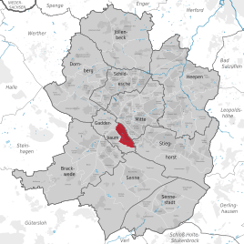
Statistical District Bethel in Bielefeld
|
|
|
The old post office in Bethel
|
|
Bethel is the name of a district and statistical district in the Gadderbaum district of the city of Bielefeld in North Rhine-Westphalia . It is best known for the seat of the Von Bodelschwingh Foundation Bethel, which gives it its name , and is considered a synonym for it , although it does not fill it in completely .
location
The district is located on the northern edge of the Gadderbaum district in the Kantensiektal east of the Bielefelder Pass . The valley lies immediately south of the Sparrenberg and Sparrenburg . Consequently, the district is located in the Teutoburg Forest . Since the densely built-up development also includes the slopes, Bethel is located at a height of around 110 m to 210 m . Neighboring districts are the statistical districts of Old and New Town, Brands Busch, Eggeweg, Lonnerbach and Osningpass.
history
The area of today's Bethel has been part of the scattered settlement of Sandhagen since the Middle Ages and consisted of several farmsteads that can be found in the street names, for example on Quellenhofweg , and some with different uses - such as the Lindenhof . The establishment of today's Von Bodelschwingh Foundation in 1867 provided a significant impetus. With their expansions, the number of buildings and the density of development grew. This foundation also had political consequences. The Bethel establishments wished for a more favorable development from their point of view, especially with regard to the question of structural issues, more freedom and the formation of their own estate district with extensive self-administration. Correspondingly, the city of Bielefeld and the municipality of Gadderbaum resisted the incorporation desired for economic and traffic reasons. The endeavors only ended with the Prussian rural community order of 1891, as the lordship was finally abolished. The incorporation of the Gadderbaumer district into Bielefeld did not take place until 1971. Discussions about a municipal special status fizzled out. During the Second World War , the village was hit by around 25,000 incendiary bombs. Basically, the Bethel district was identical to the institutions at that time. The infrastructure of these was expanded accordingly. The first telephone was connected in 1886 and in 1896 there was already a telephone system with 30 connections. The city administration of Bielefeld had only one at that time. The street lighting, power supply and the Bethel school (1920) also bear witness to the close interdependence. To this day, the water supply is guaranteed by the foundation's operations. Most of the land in the district is owned by the foundations. This fact can also be recognized by the blue signs that can be found everywhere.
buildings
The clinics, nursing homes and other buildings of the Von Bodelschwingh Foundation are characteristic. In particular, the headquarters at the so-called Betheleck and the Gilead clinics should be mentioned here. Architectural monuments are the old and new cemetery Bethel, the Zionskirche , the former gatehouse next to the main administration and the old post office. The Japanese Garden is also located in Bethel.
traffic
The district can be reached by several bus routes. In particular, the ring traffic of the city bus line 122 is used here. This is also used to connect to the Bethel tram stop . A traffic and mobility management system for the district, supported by the foundations, has existed since 1998 to coordinate all traffic. The valley location and the relatively narrow thoroughfares, combined with the high number of commuters, schoolchildren and visitors, hinder individual traffic, but also protect against speeding. In particular, the Betheleck between the clinics, the headquarters of the foundations and Artur-Ladebeck-Strasse is a hotspot for accidents.
Web links
Individual evidence
- ↑ Data from the city of Bielefeld
- ↑ Ole Heimbeck et al .: Gadderbaum - In the middle of Bielefeld. In: Bielefeld City Book 1214–2014. Bielefelder Verlag, Bielefeld 2013, p. 192.
- ↑ Gadderbaum District Representation and District Administration (Ed.): 100 Years of Gadderbaum 1883–1983. Bielefeld no year, p. 8f., 27.
- ↑ History of Bethel from 1940–1960. From Bodelschwinghsche Stiftungen Bethel, accessed on January 17, 2016 .
- ↑ Gadderbaum District Representation and District Administration (Ed.): 100 Years of Gadderbaum 1883–1983. Bielefeld n.d., p. 15.
- ↑ Traffic and Mobility Management Bethel. From Bodelschwinghsche Stiftungen Bethel, accessed on January 17, 2016 .
- ↑ Kurt Ehmke: Bethel corner remains a problem corner. Neue Westfälische , accessed on January 17, 2016 .


