Buschkamp
|
Buschkamp
District of Senne
Coordinates: 51 ° 58 ′ 11 ″ N , 8 ° 33 ′ 5 ″ E
City of Bielefeld |
|
|---|---|
| Height : | 155 m |
| Residents : | 9554 (Oct 31, 2019) |
| Incorporation : | 1st January 1973 |
| Postal code : | 33659 |
| Area code : | 0521 |
|
Location of the statistical district Buschkamp in Bielefeld
|
|
Buschkamp is a district in the Senne district of the independent city of Bielefeld in North Rhine-Westphalia .
geography
The city of Bielefeld is not further subdivided into administrative or political units below the ten districts . Districts in Bielefeld are therefore only informal sub-areas, the delimitation of which mostly relates to the area of an old community. However, Buschkamp was never a separate municipality, which makes it difficult to define the exact definition. For statistical purposes, however, Bielefeld is divided into 72 “statistical districts”. The informal district of Buschkamp corresponds roughly to the statistical district 70 Buschkamp / Togdrang in the narrower sense . In addition, the statistical district of Schillingshof is sometimes seen as part of Buschkamp.
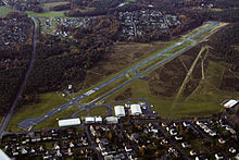
In this broad sense, Buschkamp is located directly south of the Teutoburg Forest and extends into the northern foothills of the Senne . The development extends on both sides of Paderborner Straße, the former Bundesstraße 68 . In the west the district is bounded by the Sennefriedhof , in the north by the main ridge of the Teutoburg Forest, in the east by the A2 and in the south by the Bielefeld airfield . Parts of the district are also called Togdrang or Schillingshof according to the statistical districts . Buschkamp is next to Windelsbleiche and Windflöte one of the three main settlement areas of the Senne district.
history
The district takes its name from a farm that used to stand at the intersection of B 68 / Osningstraße and was rebuilt in the nearby Senne Museum Farm . In the area of the district, which has always belonged to the municipality of Senne I in the Bielefeld district , there used to be only individual farms, but no actual village center. The planned development began in the 1920s near the Sennefriedhof, including the Sennehof cooperative settlement . The majority of today's buildings were built after the Second World War . Buschkamp has been part of the city of Bielefeld since 1973.
Churches
The Evangelical Church of Peace and the Catholic Church of the Resurrection of Christ are located in Buschkamp .
Museums
In the south-east of the district is the Senne Museum Farm, which consists of several farmhouses that have been rebuilt here, some of which are now used as a restaurant.
graveyard
The Sennefriedhof , located in the west of the district, is one of the largest cemeteries in Germany with around 100 hectares.
traffic
Buschkamp is connected to the city center of Bielefeld by line 1 of the Bielefelder Stadtbahn , the terminus of which is at the Sennefriedhof. From there, several bus lines run through the district. Bielefeld airfield is located on the southern edge of the district .


