Hillegossen
|
Hillegossen
District of Stieghorst
Coordinates: 51 ° 59 ′ 38 " N , 8 ° 36 ′ 13" E
City of Bielefeld |
|
|---|---|
| Height : | 144 m above sea level NN |
| Area : | 2.63 km² |
| Residents : | 5576 (Dec. 31, 2019) |
| Population density : | 2.120 inhabitants / km² |
| Incorporation : | 1st January 1973 |
| Postal code : | 33699 |
| Area code : | 0521 |
|
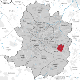
Location of Hillegossen in Stieghorst
Stadt Bielefeld |
|
Hillegossen is a district of Bielefeld and belongs to the eastern district of Stieghorst . Until 1972 Hillegossen was an independent municipality in the Office Heepen the circle Bielefeld .
geography
The city of Bielefeld is not further subdivided into administrative or political units below the ten districts . Districts in Bielefeld are therefore only informal sub-areas, the delimitation of which mostly relates to the area of an old community. For statistical purposes, however, Bielefeld is divided into 72 “statistical districts”. The old community Hillegossen corresponds roughly to the statistical district 61 Hillegossen .
Hillegossen is located on the northern edge of the Teutoburg Forest and borders the Bielefeld districts of Ubbedissen , Lämershagen , Stieghorst and Oldentrup . Coming from the Teutoburg Forest, the Selhausenbach and the Forellenbach merge in Hillegossen to form the Oldentruper Bach. With an area of 2.65 km², Hillegossen was the smallest municipality in the former Bielefeld district.
history
Hillegossen was mentioned in writing for the first time in the 12th century. Due to the abundance of water in this area, there were six water mills. Since the Middle Ages belonged peasantry Hillegossen the Bailiwick Heepen in the county Ravensberg . After the Napoleonic era , Hillegossen belonged to the Bielefeld district from 1816 and initially to the Heepen mayor's office , from which the Heepen Office was finally formed in 1843 .
Hillegossen grew very quickly after the Second World War , developed into a Bielefeld industrial and residential suburb, and structurally grew together with Bielefeld. As part of the municipal reorganization of the Bielefeld area , Hillegossen was incorporated into Bielefeld on January 1, 1973 and has since been part of the Stieghorst district.
Population development
| year | Residents | source |
|---|---|---|
| 1811 | 437 | |
| 1843 | 679 | |
| 1864 | 610 | |
| 1910 | 1263 | |
| 1939 | 1815 | |
| 1961 | 3943 | |
| 1966 | 4402 | |
| 1970 | 4323 | |
| 1972 | 4415 | |
| 2008 | 5444 | |
| 2019 | 5576 |
religion
Hillegossen originally belonged to the Protestant parish of Heepen. At the beginning of the 20th century, the Protestant parish of Stieghorst was founded for the south of the parish of Heepen, which also included Hillegossen. In 1956 Hillegossen got a church with the Christophorus House and became an independent Protestant parish. In the meantime, however, it has merged with the Stieghorst parish to form the Protestant parish of Stieghorst-Hillegossen . The Hillegosser Catholics belong to the parish of St. Bonifatius in Stieghorst.
traffic
In Hillegossen, the federal motorway 2 and the motorway-like motorway 66 intersect at the Bielefeld-Ost junction , which has been developed into a cloverleaf-shaped motorway junction . The most important inner-city street of Hillegossen is Detmolder Straße .
Hillegossen had a train station on the Bielefeld – Lage line . Here the Eurobahn operates the regional train line 73 “Der Lipperländer” and the regional express line 82 “Der Leineweber” every hour . The station has not been served since 1988, but there are considerations to reactivate it and build a second long-distance bus station.
Several bus lines connect Hillegossen with the surrounding districts as well as with the final stops Sieker (line 2) and Stieghorst (line 3) of the Bielefeld city railway .
Web links
Individual evidence
- ^ Alfred Bruns (ed.): Westfalenlexikon 1832-1835 . (Reprints for the Westphalian archive maintenance). Westphalian State Office for Archive Maintenance, Münster 1978.
- ↑ Ordinance No. 713 (establishment of the Heepen Office). (Digitized version) In: Official Journal of the Minden Government. November 17, 1843, p. 360 , accessed April 22, 2010 .
- ↑ a b c Federal Statistical Office (ed.): Historical municipality directory for the Federal Republic of Germany. Name, border and key number changes in municipalities, counties and administrative districts from May 27, 1970 to December 31, 1982 . W. Kohlhammer, Stuttgart / Mainz 1983, ISBN 3-17-003263-1 , p. 320 .
- ^ Westphalia under Hieronymus Napoleon. (Digitalisat) 1812, p. 47 , accessed on April 20, 2010 .
- ↑ Seemann: Geographical-statistical-topographical overview of the administrative district of Minden. (pdf; 802 kB) 1843, pp. 52-57 , accessed on April 23, 2010 .
- ↑ Topographical-statistical manual of the government district of Minden. (Digitized version) 1866, p. 12 , accessed on April 22, 2010 .
- ^ Uli Schubert: German community register 1910. Accessed on May 22, 2009 .
- ^ Michael Rademacher: German administrative history from the unification of the empire in 1871 to the reunification in 1990. bielefeld.html. (Online material for the dissertation, Osnabrück 2006).
- ^ Bielefeld district (ed.): 150 years Bielefeld district . 1966.
- ↑ Martin Bünermann, Heinz Köstering: The communities and districts after the municipal territorial reform in North Rhine-Westphalia . Deutscher Gemeindeverlag, Cologne 1975, ISBN 3-555-30092-X , p. 97 f .
- ↑ Social performance report 2008. (pdf; 9.5 MB) City of Bielefeld, December 31, 2008, p. 185 , accessed on May 25, 2010 : "Population of the statistical district 776 Hillegossen"
- ↑ Data from the city of Bielefeld
- ↑ Ariane Mönikes: From the train to the bus. In: New Westphalian . January 27, 2014, accessed August 18, 2020 .
