Wind flute
|
Wind flute
District of Senne
Coordinates: 51 ° 56 ′ 40 ″ N , 8 ° 29 ′ 55 ″ E
City of Bielefeld |
|
|---|---|
| Height : | 104 m |
| Residents : | 4629 (Dec. 31, 2019) |
| Postal code : | 33659 |
| Primaries : | 0521, 05209 |
|
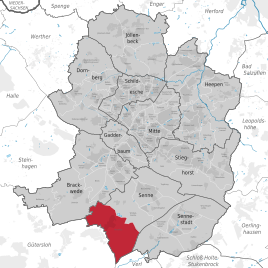
Location of wind flute in Senne
city of Bielefeld |
|
Wind flute , also known as the wind flute in local parlance , is a district in the Senne district of the independent city of Bielefeld in North Rhine-Westphalia .
geography
The city of Bielefeld is not further subdivided into administrative or political units below the ten districts . Districts in Bielefeld are therefore only informal sub-areas, the delimitation of which mostly relates to the area of an old community. Wind flute, however, was never a separate community, which makes it difficult to define exactly. For statistical purposes, however, Bielefeld is divided into 72 “statistical districts”. The informal district Windflöte corresponds roughly to the statistical district Windflöte.
Along with Windelsbleiche and Buschkamp, Windflöte is one of the three focal points of the Senne urban district and is located on the southern edge of the Bielefeld urban area in the immediate vicinity of the Friedrichsdorf district of Gütersloh . Running waters in the district are the Reiherbach , Toppmannsbach , Bekelbach and Röhrbach . Standing waters are Kampeters Kolk and several ponds of the Rieselfelder Windel .
history
The district probably owes its name to the noises caused by the strong northwest wind that often occurs here. In the area of the district, which has always belonged to the municipality of Senne I in the Bielefeld district , there used to be only individual farms, but no actual village center. In the 1920s and 1930s, the first individual houses were built in Windflöte. The planned construction of a closed residential area, triggered by the general housing shortage in the post-war years , began in 1949 on today's Erikaweg. Under the direction of the "Gemeinnützige Siedlungs- und Wohnungsbaugesellschaft Senne" (GSWG), the first cooperative residential buildings followed in 1950 on Lippstädter Strasse. In the following years the residential area expanded rapidly. First of all, the newly created living space was made available to refugees and displaced persons.
In the 1960s and 1970s, two eight- and ten-story high-rise buildings were built as the dominant elements in urban development. Windflöte has belonged to the city of Bielefeld since 1973.
Religions
The Protestant Christians in Windflöte belong to the Emmaus parish with the Luther Church on Tulpenweg, while the Catholics belong to the St. Bartholomäus parish. The Catholic St. John's Church, built in 1970, was demolished in April 2008 because it was dilapidated .
traffic
The A 33 passes close to the Windflöte settlement. The Bielefeld-Senne junction is on Buschkampstrasse between Windflöte and Windelsbleiche .
In local public transport, Windflöte is accessed by bus line 94 , which leads from Brackwede via Windelsbleiche, Windflöte and Friedrichsdorf to Gütersloh.
Individual evidence
- ↑ Population of the statistical district 992 Windflöte: Information from the city of Bielefeld (p. 187) (PDF; 9.5 MB)
- ↑ a b Horst Wasgindt, Hans Schumacher: Bielefeld Senne . Documentation about the history of the settlement. tape 2 . Westfalen Verlag, Bielefeld 1989, ISBN 3-88918-058-2 .


