Kirchdornberg
|
Kirchdornberg
District Dornberg
Coordinates: 52 ° 2 ′ 43 ″ N , 8 ° 26 ′ 22 ″ E
City of Bielefeld |
|
|---|---|
| Height : | 140 m |
| Area : | 3.13 km² |
| Residents : | 933 (Dec. 31, 2014) |
| Population density : | 298 inhabitants / km² |
| Incorporation : | 1st January 1973 |
| Postal code : | 33619 |
| Area code : | 0521 |
|
Location of Kirchdornberg in Dornberg
city of Bielefeld |
|
Kirchdornberg is a district of the city of Bielefeld in North Rhine-Westphalia and belongs to the Dornberg district . Until the local government reform in 1973 Kirchdornberg was a municipality in the Office Dornberg the district Bielefeld .
geography
The city of Bielefeld is not further subdivided into administrative or political units below the ten districts . Districts in Bielefeld are therefore only informal sub-areas, the delimitation of which mostly relates to the area of an old community. For statistical purposes, however, Bielefeld is divided into 72 statistical districts. The old community of Kirchdornberg is now part of the statistical district 41 Großdornberg / Kirchdornberg .
Kirchdornberg is located in the west of Bielefeld in the Teutoburg Forest and borders the districts of Hoberge-Uerentrup and Großdornberg from the Dornberg district. Kirchdornberg also borders the town of Werther and the municipality of Steinhagen in the Gütersloh district . The highest point in Kirchdornberg is the Petersberg at 266 m .
history
In the Middle Ages Kirchdornberg was a peasantry in the county of Ravensberg and at the same time the parish of the parish of Dornberg. From an administrative point of view, the farmers in the parish of Dornberg initially belonged to the Vogtei Brackwede and from around the beginning of the 18th century to the Vogtei Werther.
From 1807 Kirchdornberg initially belonged to the canton of Werther in the Bielefeld district of the Kingdom of Westphalia , which was ruled by Jérôme , Napoleon's brother. In 1811 the administrative structure changed because the north of the Bielefeld district was reclassified from the Kingdom of Westphalia to France . Kirchdornberg remained in the Kingdom of Westphalia and was now part of the Schildesche canton.
After the Napoleonic era , Kirchdornberg belonged to the Bielefeld district since 1816 . As part of the introduction of the new Westphalian rural community order , the Dornberg Office was founded in 1843 and Kirchdornberg was one of the five municipalities of the Office in 1845. Due to the law on the reorganization of the Bielefeld area , Kirchdornberg was incorporated into Bielefeld on January 1, 1973 and has been part of the Dornberg district since then.
Population development
| year | Residents | source |
|---|---|---|
| 1843 | 759 | |
| 1910 | 537 | |
| 1939 | 599 | |
| 1961 | 987 | |
| 1966 | 1024 | |
| 1970 | 1023 | |
| 1972 | 1160 | |
| 2008 | 989 | |
| 2014 | 933 |
traffic
Kirchdornberg is connected to Bielefeld city center by Dornberger Straße . In local public transport, bus line 24 provides a direct connection to Bielefeld city center.
Buildings
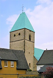
The Protestant St. Peter's Church was built in the 14th century as a three-bay Gothic hall church , making it the oldest church in Bielefeld. The Romanesque church tower is from the 11th century and has an early Gothic upper floor. Inside the church there is a carved altar with a crucifixion group from the 13th century, as well as a baroque pulpit and a baptismal font from 1685. Remains of vault and wall paintings can be dated to the 14th to 16th centuries.
Individual evidence
- ^ Statistical districts of Bielefeld
- ↑ Division of those cantons of the Bielefeld district, in the Weser department, in which two municipalities are supposed to be located. May 18, 1808, pp. 140 f , accessed on April 23, 2010 (digitized version).
- ^ Territorial division of the Bielefeld district. In: Gesetz-Bülletin des Kingdom of Westphalia Volume 2. November 20, 1812, p. 423 ff , accessed on April 13, 2010 (digitized version).
- ↑ Ordinance No. 46. (digitized version) In: Official Journal of the Minden Government. January 10, 1844, p. 21 , accessed April 22, 2010 .
- ^ Parish division of the Dornberg district. In: Official Journal of the Minden Government. September 8, 1845, accessed April 22, 2010 .
- ↑ a b c Federal Statistical Office (ed.): Historical municipality directory for the Federal Republic of Germany. Name, border and key number changes in municipalities, counties and administrative districts from May 27, 1970 to December 31, 1982 . W. Kohlhammer, Stuttgart / Mainz 1983, ISBN 3-17-003263-1 , p. 320 .
- ↑ Seemann: Geographical-statistical-topographical overview of the administrative district of Minden. (pdf; 802 kB) 1843, pp. 52-57 , accessed on April 23, 2010 .
- ^ Uli Schubert: German community register 1910. Accessed on May 22, 2009 .
- ^ Michael Rademacher: German administrative history from the unification of the empire in 1871 to the reunification in 1990. bielefeld.html. (Online material for the dissertation, Osnabrück 2006).
- ^ Bielefeld district (ed.): 150 years Bielefeld district . 1966.
- ↑ Martin Bünermann, Heinz Köstering: The communities and districts after the municipal territorial reform in North Rhine-Westphalia . Deutscher Gemeindeverlag, Cologne 1975, ISBN 3-555-30092-X , p. 97 f .
- ↑ Social performance report 2008. (pdf; 9.5 MB) City of Bielefeld, December 31, 2008, p. 185 , accessed on May 25, 2010 : "Population of the statistical district 447 Kirchdornberg"
- ↑ Statistical District Kirchdornberg. City of Bielefeld Office for Demography and Statistics, accessed on October 13, 2015 .


