
Vilsendorf
|
Vilsendorf
District Jöllenbeck
Coordinates: 52 ° 4 ′ 44 ″ N , 8 ° 32 ′ 52 ″ E
City of Bielefeld |
|
|---|---|
| Height : | 128 m |
| Area : | 5.93 km² |
| Residents : | 4269 (Dec. 31, 2019) |
| Population density : | 720 inhabitants / km² |
| Incorporation : | 1st January 1973 |
| Postal code : | 33739 |
| Area code : | 0521 |
 Location of Vilsendorf in Jöllenbeck
Stadt Bielefeld |
|
Vilsendorf is a district of the independent city of Bielefeld in North Rhine-Westphalia and belongs to the Jöllenbeck district . Until the incorporation of January 1, 1973 Vilsendorf was a municipality in the Office Jöllenbeck the circle Bielefeld . The place is at an altitude of 103 m above sea level. NN .
geography
The city of Bielefeld is not further subdivided into administrative or political units below the ten districts . Districts in Bielefeld are therefore only informal sub-areas, the delimitation of which mostly relates to the area of an old community. For statistical purposes, however, Bielefeld is divided into 72 “statistical districts”. The old community of Vilsendorf roughly corresponds to the statistical district of Vilsendorf, which today roughly defines the boundaries of the informal district of Vilsendorf.
Vilsendorf borders the Bielefeld districts Brake , Schildesche , Theesen and Jöllenbeck as well as the Herford district Laar . The southern border of the district is formed by the Johannisbach , which, coming from the west, is dammed here to the Obersee . The Jölle flows on the eastern edge of the district and forms the border with Brake. The Moorbach forms the border with Theesen in the west.
history
Vilsendorf was first mentioned in 1151. Since the Middle Ages , Vilsendorf has belonged to the Schildesche bailiwick in the Ravensberg county . After 1807 Vilsendorf belonged to the Bielefeld district of the Kingdom of Westphalia , which was ruled by Jérôme , Napoleon's brother. From 1810 to 1813 Vilsendorf even belonged directly to France and was there in the Minden district of the department of the Upper Ems . After the Napoleonic era , Vilsendorf belonged to the Bielefeld district from 1816 and initially belonged to the Schildesche mayor's office , from which the Schildesche office was formed in 1843 .
When most of the Schildesche office was incorporated into Bielefeld on October 1, 1930 and the Schildesche office was dissolved, Vilsendorf came to the Jöllenbeck office . At the same time, Vilsendorf was expanded to include the part of the Schildesche Bauer community north of the Johannisbach and west of the Jölle .
As part of the municipal reorganization of the Bielefeld area , Vilsendorf was incorporated into Bielefeld on January 1, 1973 and has been part of the Jöllenbeck district since then.
Population development
| year | Residents | source |
|---|---|---|
| 1843 | 795 | |
| 1864 | 647 | |
| 1910 | 701 | |
| 1939 | 1091 | |
| 1961 | 1890 | |
| 1966 | 1954 | |
| 1970 | 2013 | |
| 1972 | 2131 | |
| 2008 | 4043 | |
| 2014 | 4014 | |
| 2019 | 4269 |
Infrastructure
Vilsendorf consists of a residential area in the center, as well as a primary school, two kindergartens, a church, a dentist and a water mill. Agriculture shapes the picture, especially arable farming and some riding stables. There are bus connections from Vilsendorf in the direction of Jöllenbeck and Brake as well as to the Schildesche terminus of line 1 of the Bielefeld light rail .
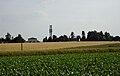
Vilsendorf is still partly rural.

Memorial stone for the 850th anniversary in 2001


Individual evidence
- ^ Alfred Bruns (ed.): Westfalenlexikon 1832-1835 . (Reprints for the Westphalian archive maintenance). Westphalian State Office for Archive Maintenance, Münster 1978.
- ^ Law on the expansion of the Bielefeld district. (pdf; 7 kB) In: Collection of Laws for the Royal Prussian States. June 11, 1930, pp. 1, 2 , accessed on April 14, 2010 .
- ↑ Stephanie Reekers: The regional development of the districts and communities of Westphalia 1817-1967 . Aschendorff, Münster Westfalen 1977, ISBN 3-402-05875-8 , p. 289 .
- ↑ a b c Federal Statistical Office (ed.): Historical municipality directory for the Federal Republic of Germany. Name, border and key number changes in municipalities, counties and administrative districts from May 27, 1970 to December 31, 1982 . W. Kohlhammer, Stuttgart / Mainz 1983, ISBN 3-17-003263-1 , p. 320 .
- ↑ Seemann: Geographical-statistical-topographical overview of the administrative district of Minden. (pdf; 802 kB) 1843, pp. 52-57 , accessed on April 23, 2010 .
- ↑ Topographical-statistical manual of the government district of Minden. (Digitized version) 1866, p. 12 , accessed on April 22, 2010 .
- ^ Uli Schubert: German community register 1910. Accessed on May 22, 2009 .
- ^ Michael Rademacher: German administrative history from the unification of the empire in 1871 to the reunification in 1990. bielefeld.html. (Online material for the dissertation, Osnabrück 2006).
- ^ Bielefeld district (ed.): 150 years Bielefeld district . 1966, p. 60 .
- ↑ Martin Bünermann, Heinz Köstering: The communities and districts after the municipal territorial reform in North Rhine-Westphalia . Deutscher Gemeindeverlag, Cologne 1975, ISBN 3-555-30092-X , p. 97 f .
- ↑ Social performance report 2008. (pdf; 9.5 MB) City of Bielefeld, December 31, 2008, p. 186 , accessed on May 25, 2010 : "Population of the statistical district 559 Vilsendorf"
- ^ Statistical district of Vilsendorf. City of Bielefeld Office for Demography and Statistics, accessed on October 13, 2015 .
- ↑ Data from the city of Bielefeld
Brackwede :
Brackwede |
Holtkamp |
Source |
Ummeln
Dornberg :
Babenhausen |
Großdornberg |
Hoberge-Uerentrup |
Kirchdornberg |
Niederdornberg-Deppendorf |
Schröttinghausen
Gadderbaum :
Bethel
Heepen :
Altenhagen |
Tree heather |
Brake |
Brönninghausen | Heepen |
Milse |
Oldentrup
Jöllenbeck :
Jöllenbeck |
Theesen |
Vilsendorf
middle
Schildesche :
Gellershagen |
Sudbrack | Schildesche
Senne :
Buschkamp |
Diaper bleach |
Wind flute
Sennestadt :
Dalbke |
Eckardtsheim |
Heather flowers | Sennestadt
Stieghorst :
Hillegossen |
Lämershagen-Graefinghagen |
Sieker | Stieghorst |
Ubbedissen