Minden District

from Wikipedia, the free encyclopedia
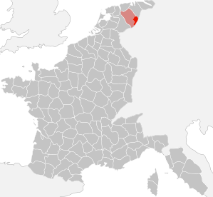
Location in France (around 1811)
Situation around 1811
Basic data (1811)
Consist: 1807-1813
Empire : France
Department : Upper Ems
Sub-prefecture : Minden
Residents: 104,808 (1811)
Structure: 10 cantons
Sub-prefect :
Absorbed in: Kingdom of Prussia
Kingdom of Hanover
Location in the department of the Upper Ems
Arr Minden - Ems-Superieure.svg

The district of Minden was part of the department of the Weser in the French vassal state Kingdom of Westphalia from 1807 to 1810 , then from 1810 until its dissolution in 1813/14 part of the department of the Upper Ems belonging to the French Empire . The sub-prefecture was Minden .

location

Location in the department of the Weser until 1810

The district was in the northeast of the French Empire, in the southeast of the department of the Upper Ems, in northern East Westphalia , north of the Wiehengebirge and mostly west of the Weser in the Mindener Land . The largest city was Minden.

Most of the area was in what is now the North Rhine-Westphalian district of Minden-Lübbecke , a small proportion in Lower Saxony (area around Uchte , today district of Nienburg / Weser ), and from 1811 also in a larger part ( Uffeln as early as 1807) in the northwest of today 's Herford district (roughly like the former Bünde district ) and in the northern Gütersloh district (around Werther ).

structure

1807

The district was established by Royal Decree of December 24, 1807. It comprised the following cantons:

District Population
(1807)
Cantons
Minden 76.203 Haddenhausen , Hausberge , Hille , Levern , Lübbecke , Minden , Oldendorf , Petershagen , Rahden , Reineberg , Windheim

In detail, the cantons consisted of the following places (French: lieux ) and cities (French: ville ):

Canton Cities, towns, villages, towns, dairies
Haddenhausen Haddenhausen and Good Haddenhausen , Oberlübbe , Unterlübbe and Kolte, Rothenuffeln , Mennighüffen and neck Tern , Obernbeck , wages Beck with Beck and Uhlenburg , Wulferdingsen , Barkhausen , Aulhausen, Uphausen , Dützen , Hummelsbeck , Bölhorst , Biemke , Dehme , Volmerdingsen and Sundern , Eidinghausen , Werste
Local mountains Hausberge , Holzhausen , Costedt , Amorkamp and Rothenhof , Vennebeck , Möllbergen , Holtrup and Vössen , Uffeln , Nammen , Kleinenbremen , Wülpke , Lerbeck , Meißen , Neesen , Schermbeck

from April 1808
Todtemann , Veltheim , Eisbergen , Fülme , Lohfeld

Hille Hille , Wiekriede and Dreierskrug, Südhemmern , Nordhemmern , Eickhorst , Holzhausen , Frotheim , Gehlenbeck (with Eilhausen ), Nettelstedt , Isenstedt
Levern Levern , Sundern , Destel , Twiehausen , Mehnen , Wehden , Oppenwehe , Oppendorf , Westrup , Dielingen , Drone , Haldem (with Haldem Castle ), Arrenkamp , Blumenhorst, Vehlage
Luebbecke Lübbecke , Obernfelde , goods Renkhausen and Eickel , Alswede , Hedem , Hollwinkel , Lashorst , Hüffe , Fabbenstedt , Fiestel (with Ellerburg and Gut Benkhausen ), Blasheim , Mehnen , Stockhausen with Gut Stockhausen
Minden City of Minden
Oldendorf Oldendorf , Offelten , Engershausen , Harlinghausen , Schröttinghausen , Getmold , Holzhausen , Heddinghausen, Börninghausen , Eininghausen
Petershagen City of Petershagen , Eldagsen , Maaslingen , Meßlingen , Südfelde , Ovenstädt , Halle, Hävern , Friedewalde (including Himmelreich), Altenburg and Heide, Stemmern , Schluesselburg , Roden, Buchholz (including Klein-Leese), Großenheerse , Todtenhausen , Kutenhausen , Hartum , Hahlen
Rahden Rahden , Großendorf , small village , Varl , Ströhen , Alas , Bergenhusen, Nutteln , Lange Horst , Barl , Linteln , Hahn Kamp, Tonnenheide , Schmalge , Auburg , Neustadt, Haslingen , Förlingen , Böckel
Reineberg Domain Reineberg , Oberbauerschaft , Schnathorst , Tengern , Holsen , Bröderhausen , Hüllhorst , Ahlsen , Büttingdorf , Lengern , Quernheim with Abbey Quernheim , Klosterbauerschaft , Rehmerloh , Gohfeld and Grimminghausen, Bischofshagen, Jöllenbeck , Depenbrock, Melbergen, Löhne , Falkendiek
Windheim Windhein , Döhren and Seelenfeld , Ilse and Wulfhagen , Jossen, Neuenknick , Rosenhagen , Gorspen and Vahlsen , Lahde , Bierde , Quetzen , Ilserheide , Raderhorst , Heimsen (with Hunerburg dairy), Ilvese , Dankersen , Hasenkamp , Frille , Wietersheim , Päpinghausen , Leteln , Aminghausen

1811

The district of Minden was largely retained when it was incorporated into France. All areas east of the Weser were given up (except for a part of Minden, roughly like the district of Rechtes Weserufer ). The canton of Windheim and the canton of Hausberge were incorporated into the Rinteln district (from 1811: Department of the Leine ). In addition, Haddenhausen, Hille, Oldendorf and Reineberg lost their function as canton capital. Their areas were added to existing cantons or part of the new cantons or the newly formed canton of Quernheim.

In turn, the district received the former to the district Rinteln (department of the Weser) belonging lamp and other cantons of Bielefeld District , the north all or part of the Werre , the Aa / Johannisbach and Schwarzenbach were, including all or part of the cantons Werther, frets, Narrow (all formerly Bielefeld district, department of the Weser). Its population increased significantly by around 30,000. Around 1811 the district was divided into the following cantons :

District Population
(1811)
Cantons
Minden 104,808 Bünde , Enger , Levern , Lübbecke , Minden , Petershagen , Quernheim , Rahden , Uchte and Werther

In detail, the cantons in 1812 consisted of the following places (French: lieux ) and cities (French: ville ), which were divided into mayor's offices (French: Mairie ) as follows . Mennighüffen has been added as the canton capital. Overall, a population of 111,644 is given for 1812.

Canton Mairie Cities, towns, villages, towns, dairies
Minden Minden City of Minden (all parts to the left of the Weser and area in a semicircle measuring 1950 meters in diameter with the center on the right-hand Weser bridge bearing)
Dützen Dützen, Barkhausen , Bölhorst , Häverstädt , Wedigenstein , Hummelbeck , Erbe, Aulhausen, Uphausen
Bergkirchen Bergkirchen, Oberlübbe , Unterlübbe , Rothenuffeln , Haddenhausen , Költe, Ellerbusch , Biemke , Luttern, Liliensiek, Heide, Eicksen, Siebenackern Költerholz, Höfen, Hilverdingen, Elfte, Lohof, Korfskamp, ​​Meente, Maschweg
Frets Frets Bünde , Holsen , Muckum , Ennigloh , Dünne , Ahle , Hußen, Spradow , Werfen , Hunnebrock , Knolle
Hiddenhausen Hiddenhausen , Eilshausen , Lippinghausen , Oetinghausen
Kirchlengern Kirchlengern , Südlengern , Häver , Quernheim
Rödinghausen Rödinghausen , Westkilver , Ostkilver , Schwenningdorf , beers
Tighter Tighter Enger , Besenkamp , Belke , Steinbeck , Herringhausen , Westerenger , Siele , Dreyen , Oldinghausen , Pödinghausen
Herford Laar , Eickum , Diebrock , Stedefreund , Radewig , Schweicheln , Bermbeck
(Note: The actual city of Herford was not French, but was in the Kingdom of Westphalia)
Jöllenbeck Oberjöllenbeck, Niederjöllenbeck
Shield ash Schildesche, Theesen with Gut Brockhagen , Brake , Vilsendorf
Levern Levern Levern, Sundern , Destel , Twiehausen , Mehnen
Woes Wehden, Oppenwehe , Oppendorf , Westrup
Dielingen Dielingen, Arrenkamp , Drone , Haldem , Blumenhorst
Alswede Alswede, Fabbenstedt , Vehlage , Hedem with Hollwinkel , Lashorst and Hüffe , Fiestel (with Ellerburg and Benkhausen )
Luebbecke Luebbecke Lübbecke, Obernfelde , Renkhausen , Eickel
Blasheim Blasheim, Mehnen , Stockhausen
Gehlenbeck Gehlenbeck, Nettelstedt , Frotheim , Isenstedt , Eilhausen
Holzhausen Holzhausen, Heddinghausen
Borninghausen Börninghausen, Eininghausen
Oldendorf Oldendorf, Engershausen , Offelten , Schröttinghausen , Harlinghausen , Getmold
Mennighüffen Mennighüffen Mennighüffen, Löhne with Beck , Obernbeck , Uhlenburg , Grimminghausen
Eidinghausen Eidinghausen, Werste
Volmerdingsen Volmerdingsen
Stupid Stupid
Wulferdingsen Wulferdingsen, Wolmerdingsen, Kroppeloh, Bollinghofen, Eidinghausen , Bunte, Riege, Brink, Sundern
Petershagen Petershagen Petershagen, Eldagsen , Maaslingen , Meßlingen , Südfelde
Todtenhausen Todtenhausen, Kutenhausen
Ovenstädt Ovenstädt, Halle, Hävern , Glißen, Westenfeld, Brüninghorstedt, Bramerloh
Friedewalde Friedewalde, Himmelreich, Altenburg, Heide, Stemmern , Wegholm
Hartum Hartum, Hahlen , Nordhemmern , Holzhausen
Buchholz Buchholz, Großenheerse , Kleinenherse , Langern and Diete
Key castle Shlisselburg, Vorburg-Shlisselburg, Röhden
Hille Hille, Südhemmern , Eickhorst , Wiekriede and Dreyerskrug
Schnathorst Schnadhorst, Tengern , Holsen , Bröderhausen
Quernheim Quernheim Quernheim, Rehmerloh
Upper peasantry Upper peasantry
Monastery farmers Monastery farmers
Hüllhorst Hüllhorst, Büttendorf , Reineberg , Ahlsen
Rahden Rahden Rahden, Großendorf , Kleinendorf , Ströhen , Varl , Wehe (with the villages of Husen, Nutteln , Langenhorst , Barl , Linteln , Hanenkamp , Tonheide , Schmalge , Küte )
Auburg Auburg, Böckel, Neustadt, Förlingen , Haslingen
(note: without Wagenfeld )
Diepenau Diepenau, Nordel , Bohnhorst , Lavelsloh , eaters and the hamlet Bramkamp , Steinbrink , Osterloh , Bohnhorsterhöfen , Dumhorn , Quelhorst , Hasselfelderhahlen , House Kampen , Hasselhorn , Honaforde , Schammerloh , Vienna Bracke , High Weggelisten , measuring angle , Mohr Linge , Bramerloh and Brüninghorstedt
Warmsen Warmsen, Großenvörde , Kappellohe, Kleinenvörde , Brockhorn, Wohlhorst, Bahlen
To rush To rush
Uchte Uchte Uchte with the farmers: Höfen , Lohe , Hamme , Osterkamp , Bülten , Bremerlohe , Damkrug , Diede , Diersdorf , Gresebilde , Haestemsen , Holte , Kalteschale and Kreuzkrug
Church Village Kirchdorf, Hoysinghausen , Woltringhausen , Holzhausen, Bahrenborstel , Scharringhausen , Frestorf , Kuppendorf , Heerde , Huddestorf , Hanstedt , Jenhorst , Harrienstedt , Raddestorf
Werther Werther Werther, Theenhausen , Rotingdorf , Rotenhagen , Häger , Schröttinghausen , Deppendorf
Spenge Spenge, Lenzinghausen , Hücker , Aschen
Wallenbrück Wallenbrück, Helgen, Baar , Düttingdorf
Hall Halle, Oldendorf , Hesseln , Eggeberg , Ascheloh , Hörste

Further development

The district largely merged into the Prussian civil government between Weser and Rhine and from 1816 onwards essentially (excluding the canton Uchte and northern part of the canton Rahden → to the Kingdom of Hanover ) formed the northern part of the administrative district of Minden , the districts of Rahden and Bünde as a whole, and the district of Minden predominantly and the district of Halle (Westphalia) partially.

literature

  • Friedrich Justin Bertuch (ed.): General geographical ephemeris . With charts and copper. Volume six and thirtieth. Verlage des Landes-Industrie-Comtoirs, Weimar 1811 ( full text in the Google book search [accessed on December 7, 2011]).
  • Peter Adolph Winkopp (ed.): The Rhenish Federation . A journal with historical-political-statistical-geographic content. Volume nineteenth. JEB Mohr, Frankfurt am Main 1811 ( full text in the Google book search [accessed December 7, 2011]).
  • Royal decree ordering the division of the kingdom into eight departments . List of the departments, districts, cantons and communes of the kingdom. In: Landschaftsverband Westfalen-Lippe (Hrsg.): Project Westphalian history . S. 227–231 ( PDF 4.9MB [accessed December 7, 2011]).

Individual evidence

  1. a b P.U. Winkopp (Ed.): The Rhenish Confederation . A journal with historical-political-statistical-geographic content. Volume nineteenth. JEB Mohr, Frankfurt am Main 1811, p. 134 ( full text in Google Book Search [accessed December 7, 2011]).
  2. a b Royal Decree, which orders the division of the kingdom into eight departments . List of the departments, districts, cantons and communes of the kingdom. In: Landschaftsverband Westfalen-Lippe (Hrsg.): Project Westphalian history . S. 227–231 ( PDF 4.9MB [accessed December 7, 2011]).
  3. Albrecht Lasius: The French Imperial State under the government of Emperor Napoleon the Great in 1812 . A geographic-historical manual. Volume nineteenth. Kißling, Osnabrück 1813, p. 201 ( full text in Google Book Search [accessed December 7, 2011]).

Coordinates: 52 ° 21 '  N , 8 ° 47'  E