
Warmsen
| coat of arms | Germany map | |
|---|---|---|

|
Coordinates: 52 ° 27 ' N , 8 ° 51' E |
|
| Basic data | ||
| State : | Lower Saxony | |
| County : | Nienburg / Weser | |
| Joint municipality : | Uchte | |
| Height : | 46 m above sea level NHN | |
| Area : | 81.61 km 2 | |
| Residents: | 3255 (Dec. 31, 2019) | |
| Population density : | 40 inhabitants per km 2 | |
| Postal code : | 31606 | |
| Area code : | 05767 | |
| License plate : | NI | |
| Community key : | 03 2 56 034 | |
| LOCODE : | DE DWS | |
| Community structure: | 6 districts | |
| Address of the municipal administration: |
Extension Warmsen Am Bahnhof 4 31606 Warmsen |
|
| Website : | ||
| Mayor : | Karsten Heineking ( CDU ) | |
| Location of the municipality of Warmsen in the Nienburg / Weser district | ||
  |
||

Warmsen is a municipality in the Uchte municipality in the Nienburg / Weser district in Lower Saxony . The community has about 3,500 inhabitants and covers an area of 81.61 square kilometers.
geography
Warmsen is located between Uchte in the northeast and Diepenau in the west-southwest about 5 km southeast of the Great Moor .
Community structure
history
In Hoyer Urkundenbuch Warmsen 1069, the district Bohnhorst 1210 Brüninghorstedt 1289 are mentioned. The district of Hauskämpen is mentioned for the first time in 1234 in the Westphalian document book . Already in the Middle Ages there were often disputes between the Counts of Hoya and the Minden bishops about the belonging of the places due to the geographical border location .
Both in Bohnhorst and Warmsen there are linden trees that are said to have been used by Tilly as court linden trees during the Thirty Years' War and are known as " Tilly-Linde ".
After the village was transferred to the Duchy of Braunschweig-Lüneburg in 1582 , today's area of the municipality of Warmsen belonged to the Kingdom of Hanover only since the 19th century and became Prussian in 1866 .
Incorporations
On March 1, 1974, the communities of Bohnhorst, Brüninghorstedt, Großenvörde and Sapelloh were incorporated.
politics
Municipal council
The council of the municipality of Warmsen consists of 15 councilors. This is the specified number for the member municipality of an integrated municipality with a population between 3001 and 5000 inhabitants. The council members are elected for a five-year term by local elections. The current term of office began on November 1, 2016 and ends on October 31, 2021.
The last local election on September 11, 2016 resulted in the following:
| Political party | Proportional votes | Number of seats |
|---|---|---|
| CDU | 59.42% | 9 |
| SPD | 31.05% | 5 |
| Green | 9.51% | 1 |
The turnout in the 2016 local elections was 55.40%, below the Lower Saxony average of 55.5%.
mayor
The municipal council elected councilor Karsten Heineking (CDU) as honorary mayor for the current electoral term.
Culture and sights

The church in Warmsen

The Hoyersvörde windmill

The Mösloh windmill
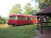
Rail bus of the Rahden – Uchte museum railway at the Bohnhorst stop


Buildings
- Gehannfors Hof is a restored farm that is used for various events in the leisure and cultural sector.
- Hoyersvörde windmill
- Windmill Mösloh
- The route of the Rahden – Uchte museum railway leads directly through Bohnhorst and Warmsen.
Economy and Infrastructure
traffic
Warmsen is on the Uchte – Rahden railway line . Trains of the Rahden – Uchte museum railway operate.
Others
- First prize in the competition "Most beautiful village in the district of Nienburg" in 1990
Individual evidence
- ↑ State Office for Statistics Lower Saxony, LSN-Online regional database, Table 12411: Update of the population, as of December 31, 2019 ( help ).
- ^ Federal Statistical Office (ed.): Historical municipality directory for the Federal Republic of Germany. Name, border and key number changes in municipalities, counties and administrative districts from May 27, 1970 to December 31, 1982 . W. Kohlhammer GmbH, Stuttgart / Mainz 1983, ISBN 3-17-003263-1 , p. 199 .
- ^ Lower Saxony Municipal Constitutional Law (NKomVG) in the version of December 17, 2010; Section 46 - Number of MPs , accessed on March 21, 2017.
- ↑ a b Warmsen municipality - overall results of the 2016 municipal council election , accessed on March 21, 2017.
- ↑ The CDU gets the most votes nationwide. September 12, 2016. Retrieved March 21, 2017 .
- ^ Warmsen local council , accessed on March 21, 2017.
Web links

Cities: Hoya | Nienburg / Weser | Rehburg-Loccum
Other municipalities: Balge | Inland | Stooping | Diepenau | Drakenburg | Estorf (Weser) | Eystrup | Gandesbergen | Haemelhausen | Hassbergen | Hassel (Weser) | Heemsen | Hilgermissen | Hoyerhagen | Husum (near Nienburg) | Landesbergen | Leese | Liebenau | Linsburg | Marklohe | Pennigsehl | Raddestorf | Rodewald | Tubes | Schweringen | Steimbke | Steyerberg | Stick | Stolzenau | Uchte | Warmsen | Warp | Wetting