
Leese
| coat of arms | Germany map | |
|---|---|---|

|
Coordinates: 52 ° 30 ' N , 9 ° 7' E |
|
| Basic data | ||
| State : | Lower Saxony | |
| County : | Nienburg / Weser | |
| Joint municipality : | Mittelweser | |
| Height : | 34 m above sea level NHN | |
| Area : | 29.66 km 2 | |
| Residents: | 1672 (Dec. 31, 2019) | |
| Population density : | 56 inhabitants per km 2 | |
| Postal code : | 31633 | |
| Area code : | 05761 | |
| License plate : | NI | |
| Community key : | 03 2 56 018 | |
| LOCODE : | DE LEX | |
| Association administration address: | Am Markt 4 31592 Stolzenau |
|
| Website : | ||
| Mayor : | Henning Olthage ( SPD ) | |
| Location of the community Leese in the district of Nienburg / Weser | ||
  |
||


Leese is a member municipality of the Central Weser municipality in the Nienburg / Weser district in Lower Saxony on the Weser .
geography
Leese lies on the Mittelweser in a marshland and geest landscape .
history
Leese was one of the first settlements in the Central Weser region. Archaeological finds indicate a Neolithic settlement around 4,000 years ago in the area of Leese. The residents worked the light, drifty sand soils in the east of today's village with primitive plows. The deceased were buried under barrows . Around 20 barrows have been found, the age of which is estimated to be around 1800 years before Christ. Further settlements were on the edge of the terrace facing the Weser (Zappenberg).
During the excavation of the Leese urn grave field by the Institute for the Preservation of Monuments between 1978 and 1980 in the “Small Field”, the largest urn grave field of the pre-Roman Iron Age in northern Germany with around 1,100 burials was discovered. The urn in the Leeser coat of arms indicates this. Around the birth of Christ the Germanic Angrivarians (= meadow people) lived here , south of it the Cheruscans .
For a long time Leese was considered the site of the battle on the Angrivarian Wall around 16 AD between the Romans under Germanicus and the Teutons under Hermann, the Cheruscan . The remains of an old defensive wall, which probably led right through the village and initially served as evidence for this assumption, was later assessed as "dating from the Middle Ages ". Experts believe that the current town of Leese was founded around 400 years after Christ. “Kerclese” was first mentioned in 1164 in a document that is in the Münster State Archives.
In the district are the desert places Om, Marslo and Osterleese. The names of these forgotten villages appear in old records of the Loccum monastery . The residents gave up their villages because of the ongoing feuds between the Counts of Hoya and the Bishops of Minden and settled in what would later become Leese. The town suffered badly in the Thirty Years' War , but later benefited as an important post office from trading on the old route along and across the Weser. In 1790 the small neighboring town of Hahnenberg was founded and officially assigned to Leese.
The village, which was formerly characterized by agriculture, has changed considerably since the beginning of the 20th century with the construction of several railway lines and the intersection of federal highways 215, 441 and 482, all of which were old military roads . Since December 1898, Leese was connected to the rail network by the Steinhuder Meer Railway . In the summer of 1935, operations on the Uchte – Rehburg Stadt section were discontinued due to insufficient utilization. From May 1921, Leese-Stolzenau was directly connected to the Reichsbahn network with the Nienburg – Minden line .
In 1937 the murder of the hunting tenants Hambster and Thürnau near Leese by two local poachers caused a sensation, a memorial stone at the scene of the crime in Seggeriede commemorates the crime.
In the years 1937 to 1943 a warfare agent factory was set up northeast of the village.
At the end of the Second World War, German soldiers blow up the Weser Bridge between Leese and Stolzenau on April 5, 1945. The village was stubbornly defended, but the English troops managed to cross the Weser. The people of Leesen fled to the forests to the east. 21 houses were destroyed by the effects of the war. Over a hundred English and German soldiers died in the fighting. For this purpose, a war cemetery was created in the center of the village. Soldiers of the British occupation forces occupy the almost operational arms factory in the Oehmer field and blown up many bunkers.
In the post-war period , Leese took in over 1,000 displaced persons from the east of the former German Empire, many of whom stayed and integrated. Up until the early 1980s, it was assumed that the first written document about Leese came from 1183. This is recorded in the Calenberg documents of the Loccum monastery. As a result, the municipality of Leese celebrated its 800th birthday in 1983. It was only shortly afterwards that it turned out that Leese had existed since 1164.
The commercial and industrial settlement of the last decades and the long-term stationing of the Bundeswehr have not significantly influenced the village character of the place. However, the Low German language continues to lose importance.
Leese has an ancient border location, first between the Angrivarians and Cheruscans, later between the county of Hoya and the diocese of Minden, then between the Kingdom of Hanover and Prussia and today between Lower Saxony and North Rhine-Westphalia.
politics
The council of the municipality of Leese consists of 11 councilors.
mayor
- previous incumbent
- 1945–1946: Wilhelm Pickel
- 1946: Ferdinand Gerke
- 1946–1948: Fritz Ebeling
- 1948–1952: Wilhelm Hotze
- 1952–1967: Heinrich Tonne
- 1967–1981: Willi Harmening
- 1981–1994: Willi Hockemeyer
- 1994-2006: Walter Hotze
- 2006–2018: Grant Hendrik Tonne (SPD)
- since 2018: Henning Olthage (SPD)
- Community director
- 1945–1965: Wilhelm Pickel
- 1965–1967: Heinrich Tonne
- 1967–1968: Willi Harmening
- 1968–1983: Friedrich Wilhelm Lehmann (Mayor of the municipality of Landesbergen)
- 1983–2006: Wilfried Henking (Mayor of Landesbergen)
- 2006–2007: Fritz-Karsten Hüneke (Mayor of the Municipality of Landesbergen)
- 2007–2011: Walter Busse (Mayor of Landesbergen)
- 2011–2016: Bernd Müller (Mayor of Central Weser)
- since 2016: Jens Beckmeyer (Mayor of Central Weser)
coat of arms
Blazon : "In red a silver oblique left wave bar, accompanied by a golden post horn at the top and a golden urn at the bottom."
Culture and sights
Low German is often spoken in the region to this day.
music
Fanfarenzug Leese eV, fire brigade music train Leese, trombone choir Leese, mixed choir in the male choir of 1864 Leese eV
Buildings
- The church, consecrated in 1874 in the neo-Gothic style, forms the center of the village center on the newly designed church square.
- The war memorial stands on a hill surrounded by large trees.
- The historic draw well can be found on the church square.

Historic draw well
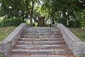
War memorial
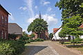
church

Town view


Regular events
- Schützenfest (first weekend in July)
- Spring fair
- Sports advertising week
Culinary specialties
In addition to potato products , asparagus cultivation plays a major role. On February 11, 2006, the largest asparagus fair in Europe took place in Leese .
Economy and Infrastructure
education
- Kindergarten Leese
- Elementary school Leese
traffic
The federal highways 215 , 441 and 482 run through Leese .
The station Leese-Stolzenau is located on the railway line Nienburg-Minden ( Weser-Aller Railway ) . It is served by the " Porta-Express " Nienburg - Minden - Bielefeld through the Eurobahn .
literature
- Heinrich Munk: 1183–1983: 800 years of the Leese community. Leese 1983, DNB 860795802 .
Web links
Individual evidence
- ↑ State Office for Statistics Lower Saxony, LSN-Online regional database, Table 12411: Update of the population, as of December 31, 2019 ( help ).
- ↑ G. Bersu, G. Heimbs, H. Lange, C. Schuchhardt: The Angrivarisch-Cheruskische Grenzwall and the two battles of the year 16 AD between Arminius and Germanicus. In: Praehistorische Zeitschrift. 17, 1926, pp. 100-131, doi : 10.1515 / prhz.1926.17.1.100 .
- ^ Description of the route 1741 (NRW part) in the NRWbahnarchiv by André Joost
- ↑ The Leese warfare agent factory at relict.com
- ↑ https://sgmittelweser.wahlen-aktuell.de/GR_Lee_16/16082316181409_0_1_txt_p_.html
- ↑ Church in Leese ( Memento of the original from March 4, 2016 in the Internet Archive ) Info: The archive link was inserted automatically and has not yet been checked. Please check the original and archive link according to the instructions and then remove this notice.

Cities: Hoya | Nienburg / Weser | Rehburg-Loccum
Other municipalities: Balge | Inland | Stooping | Diepenau | Drakenburg | Estorf (Weser) | Eystrup | Gandesbergen | Haemelhausen | Hassbergen | Hassel (Weser) | Heemsen | Hilgermissen | Hoyerhagen | Husum (near Nienburg) | Landesbergen | Leese | Liebenau | Linsburg | Marklohe | Pennigsehl | Raddestorf | Rodewald | Tubes | Schweringen | Steimbke | Steyerberg | Stick | Stolzenau | Uchte | Warmsen | Warp | Wetting