
Hassbergen
| coat of arms | Germany map | |
|---|---|---|

|
Coordinates: 52 ° 44 ' N , 9 ° 14' E |
|
| Basic data | ||
| State : | Lower Saxony | |
| County : | Nienburg / Weser | |
| Joint municipality : | Heemsen | |
| Height : | 24 m above sea level NHN | |
| Area : | 17.07 km 2 | |
| Residents: | 1571 (Dec. 31, 2019) | |
| Population density : | 92 inhabitants per km 2 | |
| Postal code : | 31626 | |
| Area code : | 05024 | |
| License plate : | NI | |
| Community key : | 03 2 56 011 | |
| Association administration address: | Wilhelmstrasse 4 31627 tubes |
|
| Mayor : | Mario Heuer ( CDU ) | |
| Location of the community of Haßbergen in the district of Nienburg / Weser | ||
  |
||

Haßbergen is a municipality in the Nienburg / Weser district in Lower Saxony .
geography
Haßbergen lies between the Wildeshauser Geest Nature Park and the Steinhuder Meer Nature Park, roughly halfway between Bremen and Hanover on the Weser . The municipality belongs to the Heemsen municipality , which has its administrative seat in the Rohrsen municipality .
history
Haßbergen was first mentioned in a document in 1096. Finds and field names suggest, however, that the settlement probably took place much earlier. From the earliest times the village was oriented towards Hoya and belonged to the Hoya district . It was not until 1932 that it was incorporated into the Nienburg / Weser district as part of the regional reform at the time .
The Folkweg passed the village north of Haßbergen and continued to the east. This old military road partially formed the border between the dioceses of Minden and Bremen.

After the construction of St. Mary's Church (1962), the chapel, the oldest building in the town, was de-dedicated and fell into disrepair in the years that followed. To draw attention to the house, the chapel and church council applied for a demolition in 1986. The impending demolition and the irretrievable loss caused by a community of interests for the continuation of the chapel in April 1988 the Heimatverein Hassbergen e. V. to found. The old chapel was given to this association in 1990 as a multi-purpose cultural space.
Origin of the place name
The old names of the place are: around 1025 Hersebergen, around 1260/1270 Hersebere, around 1265 Herseberg, around 1300 Hersebe, 1302 Herseber (e), 1308 Herseberge and around 1330/52 Hersebere.
The name has two parts. The first part used to be Herse- , it means either horse for hers or millet for herse . The second part was either -berg , i.e. mountain, hill, or -bere , i.e. forest . Since the place names are often reinterpreted for explanatory purposes, a change from the incomprehensible -ber to -berg is more likely. So Hassbergen means either horse forest or millet forest . However, millet forest is more likely; Forest in which millet grows , because there is forest millet that can cover larger areas.
politics
Municipal council
The local council from Haßbergen consists of 11 councilors and councilors.
- CDU : 5 seats
- SPD : 2 seats
- Voting community Haßbergen : 3 seats
- Greens : 1 seat
mayor
Mario Heuer ( CDU ) has been honorary mayor of the community since November 2016 . He replaced Burkhard Schmädeke, who had previously held the office for 25 years.
coat of arms
"Above the green three-mountain a silver wavy band, split by red and gold, in front a left-facing silver horse head, behind a black bell-carrier".
Culture and sights
- A special feature of the place is the small Lady Chapel made of hand-painted bricks, which is said to date from the time of the Thirty Years' War . In the old chapel, the local history association organizes readings, song, cabaret and film evenings.
The sports clubs in Haßbergen are the football club SC Haßbergen, the table tennis club TTC Haßbergen, the tennis club TSV Haßbergen, the bowling club KSC Haßbergen, the skat club Haßbergen, the shooting club and the gymnastics club MTV Haßbergen.

Old chapel

Old Mill

Town view
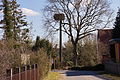
View of town with stork's nest


Economy and Infrastructure
The community is located about 10 km north of Nienburg / Weser and 25 km south of Verden (Aller) on the federal highway 215 , which cuts through the place in its entire length.
Personalities
- Rosemarie Kerkow-Weil (* 1954), German nursing and educational scientist
Web links
Individual evidence
- ↑ State Office for Statistics Lower Saxony, LSN-Online regional database, Table 12411: Update of the population, as of December 31, 2019 ( help ).
- ^ Jürgen Udolph (research): The "place name researcher". In: website NDR 1 Lower Saxony . Archived from the original on November 27, 2015 ; accessed on August 4, 2019 .
- ↑ Publishing THE RAKE: E-Paper. In: THE HARKE. Retrieved November 19, 2016 .

Cities: Hoya | Nienburg / Weser | Rehburg-Loccum
Other municipalities: Balge | Inland | Stooping | Diepenau | Drakenburg | Estorf (Weser) | Eystrup | Gandesbergen | Haemelhausen | Hassbergen | Hassel (Weser) | Heemsen | Hilgermissen | Hoyerhagen | Husum (near Nienburg) | Landesbergen | Leese | Liebenau | Linsburg | Marklohe | Pennigsehl | Raddestorf | Rodewald | Tubes | Schweringen | Steimbke | Steyerberg | Stick | Stolzenau | Uchte | Warmsen | Warp | Wetting