Pennigsehl
| coat of arms | Germany map | |
|---|---|---|

|
Coordinates: 52 ° 38 ' N , 9 ° 1' E |
|
| Basic data | ||
| State : | Lower Saxony | |
| County : | Nienburg / Weser | |
| Joint municipality : | Liebenau | |
| Height : | 48 m above sea level NHN | |
| Area : | 24.21 km 2 | |
| Residents: | 1227 (Dec. 31, 2019) | |
| Population density : | 51 inhabitants per km 2 | |
| Postal code : | 31621 | |
| Area code : | 05028 | |
| License plate : | NI | |
| Community key : | 03 2 56 023 | |
| Community structure: | 2 districts | |
| Association administration address: | Ortstr. 28 31618 Liebenau |
|
| Mayor : | Rainer Lesemann ( SPD ) | |
| Location of the community Pennigsehl in the district of Nienburg / Weser | ||
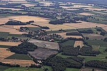
Pennigsehl is a municipality in the Nienburg / Weser district in Lower Saxony . The community is part of the joint community Liebenau , which its administrative headquarters in the spots Liebenau has.
geography
location
Pennigsehl is located south of the federal highway 214 between Nienburg / Weser and Sulingen .
Community structure
- Mainsche
- Hesterberg
- Pennigsehl
history
Prehistoric finds and barrows from the Bronze Age indicate settlement around 1800–700 BC. Chr. Hesterberg was mentioned in a document as early as 1039. Pennigsehl is mentioned for the first time in a feudal register of the Counts of Hoya , which was written around 1300. The first documentary mention comes from the year 1358 from a purchase contract between the noble lords of Mandelsloh and the counts of Hoya. The inheritance register of 1583, which was created by their heirs, the dukes of Braunschweig-Lüneburg , after the Hoya counts died out, names 14 farms. During the Thirty Years War , several farms were destroyed and some of them were not managed again afterwards. There has been a school in Pennigsehl since 1694. Hesterberg has had its own school since 1911. On April 11, 1945 Pennigsehl was occupied by a British tank unit.
Since 1992 there has been a partnership with the municipality of Plötzkau in Saxony-Anhalt .
Incorporations
Until 1932, today's municipality was still divided into two municipalities and also two districts. The community Pennigsehl belonged to the district of Nienburg and the community of Hesterberg to the district of Stolzenau . After that, the two former communities belonged to the new district of Nienburg / Weser and from 1968 to the newly formed community of Liebenau.
On March 1, 1974, the parishes merged to form the new parish Pennigsehl.
politics
Municipal council
The Pennigsehl parish council is made up of eleven councilors.
- GLPM 11 seats
(Status: local election on September 11, 2016)
mayor
In the 2011-2016 municipal election period, Rainer Lesemann (SPD) served as honorary mayor of the Pennigsehl community. In 2016 Rainer Lesemann was re-elected for a further 5 years.
coat of arms
The coat of arms of the municipality of Pennigsehl contains a golden heather scythe in the lower part in the red mountain and a black sheepfold in the upper golden part.
literature
- Friedrich Bomhoff: Pennigsehl / Mainsche - Geestdörfer between forest and moor , Pennigsehl 1992
Web links
Individual evidence
- ↑ State Office for Statistics Lower Saxony, LSN-Online regional database, Table 12411: Update of the population, as of December 31, 2019 ( help ).
- ^ Wilhelm von Hodenberg: Hoyer Urkundenbuch . tape VIII , Certificate 8 of June 4th, 1039. Hanover 1855.
- ^ Wilhelm von Hodenberg: Hoyer Urkundenbuch . tape I , certificate 162 dated March 11, 1358. Hanover 1855.
- ^ Federal Statistical Office (ed.): Historical municipality directory for the Federal Republic of Germany. Name, border and key number changes in municipalities, counties and administrative districts from May 27, 1970 to December 31, 1982 . W. Kohlhammer GmbH, Stuttgart / Mainz 1983, ISBN 3-17-003263-1 , p. 199 .
- ↑ https://wahlen.kdo.de/content.php?kunde=sg_liebenau&wahlverz=sg_liebenau/web/201609_K__Gemeinderatswahl_Pennigsehl_11.09.2016&wahlname=Gemeinderatswahl_Pennigsehl_11.09.2016&atei=160731103125493_0_1_txt_s_.html
- ↑ https://www.liebenau.com/allris/pa020.asp?PALFDNR=1000045&SORT=1am_sskn


