Linsburg
| coat of arms | Germany map | |
|---|---|---|

|
Coordinates: 52 ° 36 ' N , 9 ° 18' E |
|
| Basic data | ||
| State : | Lower Saxony | |
| County : | Nienburg / Weser | |
| Joint municipality : | Steimbke | |
| Height : | 47 m above sea level NHN | |
| Area : | 23.53 km 2 | |
| Residents: | 955 (Dec. 31, 2019) | |
| Population density : | 41 inhabitants per km 2 | |
| Postal code : | 31636 | |
| Area code : | 05027 | |
| License plate : | NI | |
| Community key : | 03 2 56 020 | |
| Association administration address: | Kirchstrasse 4 31634 Steimbke |
|
| Website : | ||
| Mayor : | Jürgenlesenberg (Linsburg voter community) | |
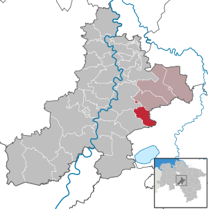
| Location of the community of Linsburg in the district of Nienburg / Weser | ||
Linsburg is a municipality in the Nienburg / Weser district in Lower Saxony and is part of the Steimbke municipality .
geography
The municipality of Linsburg is located on the northern edge of the Grinderwald state forest , about 10 minutes by car south of the district town of Nienburg / Weser .
history
The first settlement of the area can be seen in the Linsburg large stone grave located about 3.5 kilometers southeast of Linsburg in the Grinderwald , which was built about 4500 years ago. In a document from 1263 reference is made to a noble family "de Linesburg". A ducal hunting camp that probably already existed in the 16th century, which was expanded over time into a hunting lodge with 10 buildings, was expanded by the dukes of Calenberg to the representative Linsburg hunting lodge at the end of the 17th century . From 1770 the castle was demolished because it had been largely unused since the elector's departure to Great Britain in 1714.
In 2003 Linsburg celebrated its 800th anniversary, which goes back to a document from 1203 with the first mention of the place Linsburg.
A self-contained settlement was built at the station in the 1950s.
politics
Municipal council
The council of the community of Linsburg consists of nine councilors and councilors. This is the specified number for the member municipality of an integrated municipality with a population between 501 and 1000 inhabitants. The council members are elected for a five-year term by local elections. The current term of office began on November 1, 2016 and ends on October 31, 2021.
The last local election on September 11, 2016 resulted in the following:
| Political party | Proportional votes | Number of seats |
|---|---|---|
| Flat share Linsburg | 54.18% | 5 |
| CDU | 25.94% | 2 |
| GREEN | 7.79% | 1 |
| SPD | 6.26% | 1 |
| Individual applicants | 5.81% | 0 |
The turnout in the 2016 local elections was 67.59%, above the Lower Saxony average of 55.5%.
mayor
The local council elected the council member Jürgenlesenberg (WG Linsburg) as honorary mayor for the current electoral term.
coat of arms
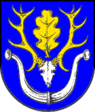
The coat of arms was approved by the district on December 6, 1983.
Blazon : "In blue a golden twelve-pointed deer antlers with a silver skull, between the antler rods an erect oak leaf, under the antlers two open silver buffalo horns."
The design and the design of the coat of arms come from the heraldist Heinz Bannier from Dörverden.
Culture and sights
Buildings
In Grinderwald is a purpose-built in 1977, 134 meters high is the telecommunications tower of Deutsche Telekom with an operating floor in 80 meters.
Stone age grave
The Linsburg large stone grave, incompletely preserved with five stones, is located about 3.5 kilometers south-east of Linsburg in the Grinderwald . It is located in a forest department lined with beech trees . The place has been called "near the five stones" since ancient times. Another large stone grave can be found in the vicinity, the Devil's Bed at Stöckse .
Economy and Infrastructure
traffic
Linsburg is connected to federal highway 6 in a south-westerly direction . The Wunstorf – Bremen railway runs north-east of the municipality with its own stop. There is a train connection in every hour with the train line 2 Nienburg - Hannover main station - Haste .
Web links
Individual evidence
- ↑ State Office for Statistics Lower Saxony, LSN-Online regional database, Table 12411: Update of the population, as of December 31, 2019 ( help ).
- ^ Lower Saxony Municipal Constitutional Law (NKomVG) in the version of December 17, 2010; Section 46 - Number of MPs , accessed on March 27, 2017.
- ↑ a b Municipality of Linsburg - overall results of the 2016 municipal council election , accessed on March 27, 2017.
- ↑ The CDU gets the most votes nationwide. September 12, 2016. Retrieved March 27, 2017 .
- ^ Linsburg local council , accessed on March 27, 2017.


