
Grinderwald
| Grinderwald | |
|---|---|
| Highest peak | Hüttenberg ( 106 m above sea level ) |
| location | Hanover region and Nienburg / Weser district ; Lower Saxony ( Germany ) |
| Coordinates | 52 ° 34 ' N , 9 ° 22' E |

The Grinderwald is a mixed forest with up to 106 m above sea level. NHN high ridge . It is located between Neustadt am Rübenberge and Nienburg / Weser in the Hanover region and in the Nienburg / Weser district in Lower Saxony .
geography
location
The Grinderwald is located in the northern part of the Steinhuder Meer Nature Park around 33 kilometers (as the crow flies ) northwest of the city center of Hanover , between Neustadt am Rübenberge in the southeast and Nienburg / Weser in the northwest. The villages on the edge of the forest include Borstel , Hagen , Eilvese , Schneeren , Bolsehle and Linsburg . The sources of the Hagener Bach , a western tributary of the Leine , are located in the Grinderwald and the surrounding area ; from the Katzenbach, from the Linsburger Bach, whose water flows northwest through the Führser Mühlbach to the Weser , and from the Strangbach, a southeast tributary of the Steinhuder Meerbach . South-southeast of the Grinderwald lies the Dead Moor , to which the Steinhuder Meer adjoins in the southwest .

The landscape protection area Grinder Wald ( CDDA no. 321161; designated 1966; 11.777 km² ) is located on large parts of the Grinderwald , to which the LSG Schneerener Geest-Eisenberg (CDDA no. 324228; 1967; 85.66 11.777 km²).
Natural allocation
The Grinderwald belongs in the natural spatial main unit group Weser-Aller-Flachland (No. 62), in the main unit Hannoversche Moorgeest (622) and in the subunit West-Hannoversche Moorgeest (622.0) mainly to the natural area Husum-Linsburger Geest (622.00); it has southwest to southern foothills in the natural area Rehburger Moorgeest (622.02).
Surveys
The surveys in the hilly terrain of the Grinderwald include - sorted by height in meters (m) above sea level (MSL; unless otherwise stated according to):
|
|
Flora and fauna
The majority of the approximately 1000 hectare grinder forest is state forest . The forestry tasks in the forest area are carried out by the Lower Saxony State Forests . In addition, there is around 80 hectares of private forest in the Linsburg part of the Grinderwald , which historically developed from peasant forests and is now owned by four forest interests as real associations.
Today the forest area consists of almost 80% coniferous forest with Douglas fir , spruce , pine and larch and a little over 20% of deciduous forest with birch , beech and oak . The tree species are predominantly not monoculture , but rather mixed. Forest management endeavors to increase the proportion of deciduous forest, as it is native here. Compared to other forests in the area, the Grinderwald was never cleared in previous centuries and was only converted into heather on smaller areas . This was due to its function as a hunting ground for the Guelphs . The centuries-old forest was overexploited in the 20th century as a result of overexploitation during the Second World War and logging for reparations to the British occupation forces after the war. In 1972, the Quimburga hurricane overturned 10 times the annual logging volume, so that around 20% of the forest had to be replanted with 200 hectares. In 2003, the stock of solid cubic meters of wood was estimated at 220,000 m³. In the sustainably managed Grinderwald, the amount of wood increases annually by around 4,000 cubic meters. The forest is mainly developed like a chessboard through forest paths that form the individual departments . The center of the forest area can only be reached on forest paths.
The game population that is hunted includes roe deer and rare fallow deer . There is also a population of wild boars . Smaller game species are badger , fox and brown hare .
geology

The Grinderwald is an old moraine plate that was created by debris and debris deposits during the Ice Age . In the upper area of the soil profile, there are bed load sand and brown earth . Underneath, there are gravelly meltwater sands with fist-sized rubble made from Nordic rock, as well as from Weser gravel. The mixture of sand and gravel is called grind in Low German , from which the name of the grinder forest is derived. The sandy and stony subsoil had poor soil quality and was difficult to work on for agriculture. As a result, the higher areas of the forest were preserved.
history
The large stone grave of Linsburg , which was built around 4500 years ago in the Neolithic Age , is located in the Grinderwald . The incompletely preserved grave complex was archaeologically examined for the first time in 2015. Originally, the people living on the edge of the forest used the Grinderwald to remove construction and firewood and as forest pasture for their pigs. The sovereign later issued rules for the use of forests and granted legal rights, which were the first to be owned by the Mariensee Monastery (1301) and the city of Nienburg. Later the Grinderwald belonged to the Wölpe office . According to the forest register from 1750, the forest, including meadows and fields, was almost 33,000 acres in size . When surveyed in 1776, the forest comprised approximately 15,000 acres. The Grinderwald served as a hut forest and was sufficient to fatten up to 3000 pigs. Between the Wölpe Office and the Nienburg Office , which had no share in the Grinderwald, there were repeated disputes about the forest area and its borders. This led to conflicts and bloody confrontations. In particular from the 16th and 17th centuries, incidents are known in which Nienburg citizens broke through barriers and wagons pulled wood out of the forest, which the inhabitants of the villages on the Grinderwald forcibly prevented.
Stately hunting ground

For a long time the Grinderwald served the noble lords of the Guelphs as a manorial hunting ground. Presumably Duke Erich II, who resided in Neustadt am Rübenberge , raised the forest to court hunting grounds in the 16th century. During this time, the Linsburg Hunting Lodge was built as a ten-building complex that was known as a hunting camp . He was able to accommodate the arriving royal court and its entourage. Only after the end of the Thirty Years' War did historical sources report from 1648 on the use of the hunting lodge by the Hanover-based Prince Georg Wilhelm from Calenberg , who often stayed here to hunt. When he became the ruling prince of the Principality of Lüneburg in 1665, his brother Johann Friedrich took over the hunting ground of the Grinderwald and spent several weeks a year hunting in Linsburg. During the time of his successor Ernst August , from 1680 to 1702, the hunting lodge was expanded. Two star-shaped path complexes were created in the forest for the par force hunts , which still exist today and whose two intersections were called the Small and Large Star. The movements of the game across the lanes could be followed from the path centers. After George I was made King of Great Britain and Ireland in 1714 and moved to Great Britain, hunting in the Grinderwald lost its importance. The Hanoverian kings George I and later George II hunted there only during their rare visits to the Electorate of Hanover . It was not until 1837, after the end of the personal union between Great Britain and Hanover , that stately hunting in the Grinderwald was revived under King Ernst August I. But it only lasted until the revolution of 1848 , when the former landlords renounced their hunting rights. In 1967 , the Linsburg branch of the German Forest Youth built a hunting lodge on the site of King Ernst August I's previous hunting stand .
traffic

The four-lane federal highway B 6 in the Grinderwald
|

The B 6 in the Grinderwald near Schneeren
|
The federal highway 6 runs through the southwest to southern foothills of the Grinderwald in a northwest-southeast direction, between Nienburg / Weser and Neustadt am Rübenberge . The Bremen – Hanover railway line , on which S-Bahn trains also run, runs through the northern forest areas between these villages . The train stations / stops near the forest are in Linsburg , Hagen and Eilvese .
Others
In the forest there is a cemetery for prisoners of war of the Second World War . 47 Soviet, mostly nameless people and a Polish child are buried there. The prisoners of war were used for logging in the Grinderwald and housed in a barrack camp in the nearby Meinkingsburg settlement . The prisoners, who died as a result of the physical strain and poor nutrition, were buried in the forest in the so-called "Russian cemetery". After the end of the war, other deceased prisoners of war were reburied here. Today there is the Russian soldiers memorial in Linsburg .
In the north-western area of the Grinderwald with almost 100-year-old beeches on podsolized brown earth , a scientific study of the storage of carbon in the subsoil has been taking place since 2013 . Soil scientists, micro- and forest biologists, ecosystem modelers as well as soil chemistry and soil physics projects are involved. The six-year research project is being supervised by the University of Hanover .
Within the forest there is a telecommunications tower built in 1977 by the former Deutsche Bundespost as type tower FMT 2/73 . The 138 m high tower has a service floor at a height of 80 m. There is also a Grinderwald playground (forest playground) for children in the forest .
From 1967, a military facility of the Dutch army with mobile was in Grinderwald Hawk - aircraft missiles . It was roughly on the 106 m high elevation of the Hüttenberg. After the end of the Cold War , the position was given up and the unit withdrew in 1994. When the federal highway 6 was expanded in 2006, the site served as a compensation area and was renatured.

Telecommunication tower in the Grinderwald

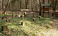
Facilities; Soil research project in the Grinderwald, 2015

A striking beech tree surrounded by stones in the Grinderwald

Forest playground
Cemetery for prisoners of war of the Second World War


legend
According to a legend , the giant Hans Lohe lived in Grinderwald from time immemorial . When one day he was visiting his brother and on the way back he was stopping to drink at the Führse stream, he noticed that sand from the Hämelheide had got into his shoes. He took off his shoes and dumped the sand next to his resting place. Thereafter, a sand hill near Stöckse is named as Hans-Loh-Berg . It is said to have been the giant Hans Lohe, who threw the Giebichenstein out of anger at the Wölper church tower and who was caught by the dwarf king Giebich.
literature
- Ludwig Hoffmeyer: The Wölpe office and the Grinderwald with the lordly hunting lodge Linsburg , Nienburg a. Weser, 1922
Web links
Individual evidence
- ↑ a b Topographic map with the Grinderwald ( memento of the original from April 10, 2016 in the Internet Archive ) Info: The archive link was inserted automatically and has not yet been checked. Please check the original and archive link according to the instructions and then remove this notice. (TK 100; heights according to DTK50 or top contour lines in AK 5 / 2.5), on natur-erleben.niedersachsen.de
- ↑ a b c Map services of the Federal Agency for Nature Conservation ( information )
- ^ Die Linsburger Holzwirtschaft , in: Die Linsburger Chronik , on gemeindelinsburg.de
- ↑ Jörg Brüning (district forester of the Grinderwald): The Grinderwald today in: 800 years Linsburg , 2003
- ^ Controversy about the Grinderwald , in Die Linsburger Chronik , on gemeindelinsburg.de
- ↑ Das Jagdschloß Linsburg , in: Die Linsburger Chronik , on gemeindelinsburg.de
- ↑ Von Jäger und Sammeln , in: Die Linsburger Chronik , accessed on August 19, 2015, on gemeindelinsburg.de
- ↑ The hut in the Grinder Forest ( Memento of the original from February 28, 2014 in the Internet Archive ) Info: The archive link was automatically inserted and not yet checked. Please check the original and archive link according to the instructions and then remove this notice. , in: TV 2020 from Nienburg
- ^ Linsburg, prisoner of war cemetery in the Grinderwald , in Friedhofsinformationen , on volksbund.de
- ^ Public institutions - The Russian Soldier Memorial , on gemeindelinsburg.de
- ↑ Nikias Schmidetzki: Students research in the Grinderwald - pipes and measurements in the leaves , from February 17, 2015, on blickpunkt-nienburg.de
- ^ The Grinderwald playground , in public institutions , on gemeindelinsburg.de
- ^ The Hawk-FlaRak-position Borstel (NL) , accessed on September 23, 2015, on relict.com
- ↑ The local sagas , in: 800 years Linsburg , 2003