
Husum (near Nienburg)
| coat of arms | Germany map | |
|---|---|---|
.png)
|
Coordinates: 52 ° 34 ' N , 9 ° 15' E |
|
| Basic data | ||
| State : | Lower Saxony | |
| County : | Nienburg / Weser | |
| Joint municipality : | Mittelweser | |
| Height : | 44 m above sea level NHN | |
| Area : | 39.85 km 2 | |
| Residents: | 2341 (Dec. 31, 2019) | |
| Population density : | 59 inhabitants per km 2 | |
| Postal code : | 31632 | |
| Area code : | 05027 | |
| License plate : | NI | |
| Community key : | 03 2 56 016 | |
| Community structure: | 4 districts | |
| Association administration address: | Behind the Höfe 13 31628 Landesbergen |
|
| Mayor : | Guido Rode ( CDU ) | |
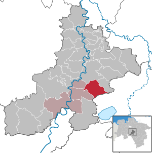
| Location of the municipality of Husum in the Nienburg / Weser district | ||
  |
||

Husum is a municipality in the Nienburg / Weser district in Lower Saxony . The community is part of the Mittelweser community , which has its administrative seat in the community of Stolzenau .
geography
location
Husum is located in the Steinhuder Meer nature park south of Nienburg and north of the Steinhuder Meer.
Community structure
The four districts of the municipality are:
- Bolsehle
- Great Varlingen
- Husum
- Schessinghausen
history
Husum is first mentioned in a document from 1250. A fire in 1774 destroyed a large part of the village and the church building built in 1250.
Together with the towns of Bolsehle, Groß Varlingen and Schessinghausen, Husum was merged into the new municipality of Husum as part of the regional reform on March 1, 1974 and integrated into the joint municipality of Landesbergen , which in turn has formed the joint municipality of Mittelweser since 2011 with the town of Stolzenau.
politics
Municipal council
The council from Husum consists of 13 councilors.
(Status: local election on September 11, 2016 )
mayor
The honorary mayor Guido Rode was elected on November 1st, 2016.
coat of arms
Blazon : "Above a hill in the shield base in confused colors gold and red, split by red and gold, in front a silver church with a silver bell tower on top, behind a black plow."
Culture and sights
- The church, built around 1200, was destroyed by fire in 1774. In the years 1776–1778, the St. Jakobi Church was rebuilt in its current form.

St. Jacobi Church

Half-timbered house (Protestant Lutheran parish hall)
_IMG_0819.JPG)
_IMG_0823.JPG)
Economy and Infrastructure
The community is located south of the federal highway 6 which leads from Nienburg / Weser to Hanover .
Web links
Individual evidence
- ↑ State Office for Statistics Lower Saxony, LSN-Online regional database, Table 12411: Update of the population, as of December 31, 2019 ( help ).
- ↑ http://maps.google.de/
- ^ Federal Statistical Office (ed.): Historical municipality directory for the Federal Republic of Germany. Name, border and key number changes in municipalities, counties and administrative districts from May 27, 1970 to December 31, 1982 . W. Kohlhammer GmbH, Stuttgart / Mainz 1983, ISBN 3-17-003263-1 , p. 199 .
- ↑ https://sgmittelweser.wahlen-aktuell.de/GR_Hu_16/160823155545546_0_1_txt_p_.html
- ↑ https://sgmittelweser.wahlen-aktuell.de/GR_Hu_16/160823155545546_0_1_txt_p_.html

Cities: Hoya | Nienburg / Weser | Rehburg-Loccum
Other municipalities: Balge | Inland | Stooping | Diepenau | Drakenburg | Estorf (Weser) | Eystrup | Gandesbergen | Haemelhausen | Hassbergen | Hassel (Weser) | Heemsen | Hilgermissen | Hoyerhagen | Husum (near Nienburg) | Landesbergen | Leese | Liebenau | Linsburg | Marklohe | Pennigsehl | Raddestorf | Rodewald | Tubes | Schweringen | Steimbke | Steyerberg | Stick | Stolzenau | Uchte | Warmsen | Warp | Wetting