
Steyerberg
| coat of arms | Germany map | |
|---|---|---|

|
Coordinates: 52 ° 34 ' N , 9 ° 1' E |
|
| Basic data | ||
| State : | Lower Saxony | |
| County : | Nienburg / Weser | |
| Height : | 27 m above sea level NHN | |
| Area : | 101.91 km 2 | |
| Residents: | 5191 (Dec. 31, 2019) | |
| Population density : | 51 inhabitants per km 2 | |
| Postal code : | 31595 | |
| Primaries : | 05764, 05023 , 05761 , 05769 | |
| License plate : | NI | |
| Community key : | 03 2 56 030 | |
| LOCODE : | DE STY | |
| Spot breakdown: | 8 districts | |
| Address of the stain management: |
Lange Str. 21 31595 Steyerberg |
|
| Website : | ||
| Mayor : | Heinz-Jürgen Weber ( CDU ) | |
| Location of the Steyerberg area in the Nienburg / Weser district | ||
  |
||


Steyerberg is a stain in Nienburg / Weser ( Lower Saxony ). The Steyerberg district has concluded an administrative cooperation with the Samtgemeinde Marklohe and the Samtgemeinde Liebenau in the form of the “Linkes Weserufer” association .
geography
Geographical location
Steyerberg is located in the Central Weser region . The joint municipality of Liebenau borders the area in the north, the joint municipality of Uchte in the west, the joint municipality of Landesbergen in the east and the municipality of Stolzenau in the south. The Große Aue flows through Steyerberg . The 'Steyerberger Berg', the only larger elevation in the area, is striking.

Spot breakdown
| Districts with the number of inhabitants (as of June 30, 2010) | |
|---|---|
| Bruchhagen | 233 inhabitants |
| Deblinghausen | 553 inhabitants |
| Düdinghausen | 287 inhabitants |
| Sarninghausen | 214 inhabitants |
| Longings | 114 inhabitants |
| Steyerberg | 3061 inhabitants |
| Voigtei | 356 inhabitants |
| Wellie | 502 inhabitants |
The former place "Rießen" is now part of the Steyerberg - a street in which the church is located.
history
.jpg)
Steyerberg Castle, first mentioned in a document in 1259, was built to protect the territory of the Hoya counts from the Minden bishops and as a counter-castle against the Novum Castrum fortress (New House). Possibly the castle stood on the land of the bishops , who saw it as a provocation . From 1265 on, Steyerberg was therefore an apple of contention between the Counts of Hoya and the Bishops of Minden , who both raised property claims. By building a castle on the Knappsberg, the Counts of Hoya were able to assert themselves as sovereigns. Since then, Steyerberg was the official seat. After the Hoya Counts died out, Steyerberg fell to the Dukes of Braunschweig Lüneburg in 1582 . During the Thirty Years' War , Steyerberg was looted and set on fire in 1625 and 1636. Around 1800 Steyerberg was occupied by Napoleon's troops. From 1829 Steyerberg belonged to the Stolzenau office . After the offices were suspended in 1867, Steyerberg belonged to the Stolzenau district , which was merged with the Nienburg / Weser district in 1932 . The Samtgemeinde Steyerberg, formed in 1968, was merged in 1974 to form a unified community of Flecken Steyerberg. The formerly independent eight municipalities thus became districts.
When the Counts of Hoya elevated the place to a patch cannot be determined exactly, but it will have been in the 14th century. From 1549 to 1766 a line of the aristocratic Münchhausen family had its seat in Steyerberg as Drosten . In 1573 the well-known Feldobrist Hilmar von Münchhausen died here . Later, his sons were enfeoffed with Steyerberg, including Statius von Münchhausen . There have been shooting festivals in Steyerberg since 1589 .
Between 1939 and 1945, the largest ammunition factory of the German chemical and armaments company EIBIA GmbH existed in the immediate vicinity of Steyerberg and Liebenau under the code name "Karl"
At the end of the Second World War , Steyerberg was taken by the British after a train carrying ammunition had been blown up in the Steyerberg train station.
In 2009 Steyerberg celebrated its 750th anniversary.
Incorporations
On March 1, 1974, the communities of Bruchhagen, Deblinghausen, Düdinghausen, Sarninghausen, Sehnsen, Voigtei and Wellie were incorporated.
Population development
|
|
politics
Municipal council
The Steyerberg municipal council has a total of 17 members. Since November 1, 2016, these have been made up as follows:
- Mayor Heinz-Jürgen Weber (CDU)
- CDU : 8 seats
- SPD : 7 seats
- Alliance 90 / The Greens : 1 seat
mayor
Heinz-Jürgen Weber (CDU) has been mayor since December 12, 2016. (Status: local elections on September 11, 2011; election of mayors on September 22, 2013)
Former mayors:
- 2005–2013 Andreas Götz
- 1998-2005 Gerd Linderkamp
...
- 1976–1991 Karl Nordmann
- 1959−? Heinrich Dolle
...
- around 1580 Reineke Hegermann


Culture and sights
- The Evangelical Lutheran Church of Sankt Katharinen zu Rießen at the eastern entrance to Steyerberg was built in major parts from around 1180 to 1250. Christian Vater's organ dates from the first half of the 18th century. In the tower hall there is a Romanesque font, which probably dates from the 10th century. The grave chamber of the family of the mercenary leader Hilmar von Münchhausen with a wooden epitaph is attached to the church.
- The official court of the Counts of Hoya was built around 1550 on the remains of Steyerberg Castle.
- In the Steyerberg watermill from 1898, which was first mentioned in 1245, the Steyerberg Heimatverein resides today, which completely renovated it in 2005 and expanded it into a local museum.
- The historic three-arched stone bridge from 1726 spans the Great Aue in front of the Meyersiek watermill.
- The sawmill from 1865 on the left side of the Große Aue opposite the watermill is part of the overall mill complex and is still in operation today.
- Around 2000 forced laborers from the powder factory in Liebenau - including many Soviet prisoners of war - were buried in the Deblinghausen war cemetery.
- The Steyerberger Schützenfest takes place every two years in June .
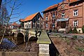
Historic bridge in front of the water mill

Meyersiek watermill
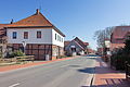
View of the town on Lange Straße

Sawmill from 1865


Economy and Infrastructure
Companies
As recently as 2005, the Steyerberg district was one of the three communities in the Nienburg district that had a surplus of commuters. The situation has worsened significantly due to plant closings.
There are several commercial areas in the municipality of Steyerberg: Auf dem Acker, Am Hasenberge and Auf dem Lichtenberge (in planning but only partially feasible due to the existing high voltage lines).
The office furniture manufacturer Rohde & Grahl GmbH, which has been at home since 1977, is located in the 'Auf dem Acker' industrial park and belongs to the Polish Nowy Styl SA The clothing factory, Karl-Heinz Rolfsmeier GmbH + Co. KG, went bankrupt in 2016. The company Oxxynova GmbH (until 2001 Degussa AG) for the production of dimethyl terephthalate has been located in the 'Am Hasenberge' industrial park and employs around 130 people.
In the district until 2013 consisted Voigtei a natural gas processing plant of the company ExxonMobil Production Germany GmbH - Location Voigtei that since the 1950s the supply of natural gas in northern Germany supported one of the few domestic sources.
There are two brickworks in the Wellie district, but one of them has been closed for several years.
From 1981 to the end of the 1990s, a state collection point for low-level radioactive waste was operated on the former site of the Industrieverwaltungsgesellschaft mbH (IVG) between Steyerberg and Liebenau. The waste was then transferred to the interim storage facility in Leese .
On June 30, 2010, 1489 men and women were working as employees subject to social security contributions in the Steyerberg district.
education
There are several educational and care facilities in the village of Steyerberg and in the districts:
- Kindergarten Wurzelhöhle, Steyerberg
- Kindergarten Wolkentraum, Steyerberg
- Kindergarten Lummerland, Voigtei
- Forest kindergarten, Steyerberg
- Deblinghausen primary school
- Primary school forest school Steyerberg
- Free school Mittelweser
The forest school's secondary school was closed in 2013.
- With the Lebensgarten , Steyerberg is home to one of the largest (140 residents) and oldest (1984) collectives in Germany. The Lebensgarten is also the seat of an education and seminar center and the Association for Mindfulness & Understanding e. V.
traffic
The Steyerberg spot is on the three state roads 349, 350 and 351. The federal highway 6 is around 15 km away and has 4 lanes in the direction of Hanover and 2 lanes in the direction of Syke and Bremen. Other federal highways located in the vicinity are federal road 441 (10 km south), federal road 215 (10 km east) and federal road 61 (15 km west). The next federal motorways are about 60 km away. The next federal motorway connections are
- Federal motorway 2 : Porta Westfalica , approx. 45 km via federal road 482 / B 215
- Bundesautobahn 7 : Schwarmstedt , approx. 45 km, then via Nienburg Bundesstraße 214 .
The Steyerberg station was on the Nienburg – Rahden railway line . This has been shut down in this area .
The closest train stations are Nienburg (Weser) on the Wunstorf – Bremen line and Leese-Stolzenau on the Nienburg – Minden ( Weser-Aller line ) , and Rahden on the Ravensberger Bahn .
The connection of the districts with each other and with the surrounding places is via local and regional bus lines of the Verkehrsgesellschaft Landkreis Nienburg .
Personalities
- Hilmar von Münchhausen (1512–1573), German mercenary leader , royal Spanish colonel, pawnbroker and drost at Steyerberg Castle since 1565, died there in 1573
- Ernst Friedrich Bouchholtz (1718–1790), German lawyer, author and Mecklenburg diplomat
- The political scientist and television presenter Ilka Eßmüller comes from Steyerberg.
- The former member of the Bundestag Sebastian Edathy (SPD) lived in Steyerberg.
- The well-known reciter Horst Peters was also born in Steyerberger.
- René Rast , German racing driver, winner of the 2008 Porsche Carrera Cup, German ADAC Junior Kart Champion 2002 and winner of the German Touring Car Masters DTM 2017, grew up in Steyerberg.
- Hans Christian Brandy , state superintendent of the Stade district , was pastor in Steyerberg from 1991–1994.
- The well-known ecologist and capitalism critic Margrit Kennedy lived here.
literature
- Heinrich Gade : Historical-geographical-statistical description of the counties Hoya and Diepholz. 2 volumes. Schaper, Hanover 1901.
- Arnold Pieper: From Steyerberg's past days . Würzburg-Aumühle 1941.
Web links
Individual evidence
- ↑ State Office for Statistics Lower Saxony, LSN-Online regional database, Table 12411: Update of the population, as of December 31, 2019 ( help ).
- ↑ Change in the mayor's office to dieharke.de, accessed on October 14, 2013.
- ^ Website on the history of the powder factory
- ↑ Website for the 750th anniversary celebration in 2009
- ^ Federal Statistical Office (ed.): Historical municipality directory for the Federal Republic of Germany. Name, border and key number changes in municipalities, counties and administrative districts from May 27, 1970 to December 31, 1982 . W. Kohlhammer, Stuttgart / Mainz 1983, ISBN 3-17-003263-1 , p. 199 .
- ↑ Lit .: The development in Flecken Steyerberg up to 2020 in a demographic outlook up to 2030 - ISP Eduard Pestel-Institut für Systemforschung e. V., December 2006 on behalf of Steyerberg
- ↑ https://wahlen.kdo.de/content.php?kunde=flecken_steyerberg&wahlverz=flecken_steyerberg/web/201609_K__Gemeindewahl_11.09.2016&wahlname=Gemeindewahl_11.09.2016&atei=160727112531044_0_1_txt_s_.html
- ^ Mayor of Steyerberg
- ↑ Watermill Steyerberg
- ↑ Website of the Heimatverein
- ^ Voigtei on the Exxonmobil website
- ↑ https://www.waldkindergarten-steyerberg.de
- ↑ http://www.freieschulemittelweser.de/
- ↑ Lebensgarten.de

Cities: Hoya | Nienburg / Weser | Rehburg-Loccum
Other municipalities: Balge | Inland | Stooping | Diepenau | Drakenburg | Estorf (Weser) | Eystrup | Gandesbergen | Haemelhausen | Hassbergen | Hassel (Weser) | Heemsen | Hilgermissen | Hoyerhagen | Husum (near Nienburg) | Landesbergen | Leese | Liebenau | Linsburg | Marklohe | Pennigsehl | Raddestorf | Rodewald | Tubes | Schweringen | Steimbke | Steyerberg | Stick | Stolzenau | Uchte | Warmsen | Warp | Wetting
Bruchhagen | Deblinghausen | Düdinghausen | Sarninghausen | Tendons | Steyerberg | Voigtei | Wellie