Prussian Ströhen
|
Prussian Ströhen
City of Rahden
Coordinates: 52 ° 30 ′ 35 ″ N , 8 ° 37 ′ 50 ″ E
|
|
|---|---|
| Height : | 38 m above sea level NN |
| Area : | 32.5 km² |
| Residents : | 1930 (Jan. 1, 2012) |
| Population density : | 59 inhabitants / km² |
| Incorporation : | 1st January 1973 |
| Postal code : | 32369 |
| Area code : | 05776 |
|
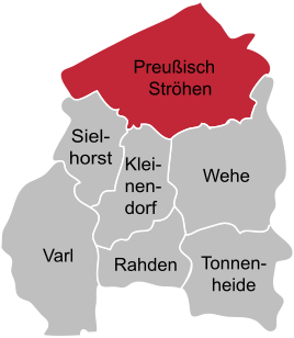
Location of Preußisch Ströhen in Rahden
|
|
Preussisch Ströhen is a town in the town of Rahden in the East Westphalian district of Minden-Lübbecke and the northernmost town in the state of North Rhine-Westphalia . The addition "Prussian" serves to distinguish it from the neighboring town of Ströhen in the municipality of Wagenfeld, which is called "Hannoversch Ströhen" . Preussisch Ströhen was the largest municipality in terms of area in the former Lübbecke district and is now the largest district in terms of area of the corresponding old district. The head of the village is Bianca Winkelmann ( CDU ).
geography
Prussian Ströhen is on average 38 m above sea level. NN and at the mouths of the Kleine Aue , the Große Dieck River and the Wickriede in the Große Aue . Because of the low relief energy in the Diepholzer Moorniederung , there were repeated strong floods, so that the haymaking in particular could often not be brought in. However, due to extensive regulatory measures, which began in 1856 as a "great digging" and could only be completed in 1967, the valley sand areas are now drained. Because of the high groundwater, the lowlands are used as permanent grassland, and arable farming is practiced on the valley ridges.
The village lies between the cities of Rahden , Diepholz , Sulingen and lay on the railroad Bassum-Herford , which in this area shut down is. Prussian Ströhen has 1930 inhabitants (January 2012) and belongs to the city of Rahden. To the north, Prussian Ströhen is bounded by the Lower Saxony district of Diepholz , municipality of Wagenfeld . The northernmost point of the place is also the northernmost point of North Rhine-Westphalia ( " NRW North Point ").
To the west of the town center is the 3.7 hectare Karlsmoor nature reserve .
history
The earliest documentary mention was made of Prussian Ströhen, then called Stroden (swampy terrain), in 1088. From 1310 it is known that 15 farms belonged to Ströhen at that time. In 1647 there were already 56. To date, the number has grown to well over 500.
In 1843, Preussisch Ströhen became an independent municipality in what was then the Rahden office . On January 1, 1973, it was merged with the other municipalities of the Rahden office to form the town of Rahden.
Attractions
- North Rhine-Westphalia
- The Protestant Immanuel Church was consecrated in 1857. For lack of money it was initially built without a church tower; the tower was only added about 35 years later. The church was built in the style of the Berlin Schinkel School. The then Prussian King Friedrich Wilhelm IV contributed a gift of 4,000 Reichstalers to its construction. Today the church is a listed building . It has recently become an “Open Church” and a “Cyclist Church”.
Individual evidence
- ^ Federal Statistical Office (ed.): Historical municipality directory for the Federal Republic of Germany. Name, border and key number changes in municipalities, counties and administrative districts from May 27, 1970 to December 31, 1982 . W. Kohlhammer, Stuttgart / Mainz 1983, ISBN 3-17-003263-1 , p. 325 .
- ↑ Open Churches: The Immanuel Church in Preussisch Ströhen ( Memento of the original from July 26th, 2009 in the Internet Archive ) Info: The archive link has been inserted automatically and has not yet been checked. Please check the original and archive link according to the instructions and then remove this notice.
Web links
- Prussian Ströhen on the website of the city of Rahden
- preussisch-stroehen.de
- Prussian Ströhen in the Westphalian Cultural Atlas

