
Wiehengebirge
| Wiehengebirge | ||
|---|---|---|
 The Wiehengebirge near Schnathorst seen from the southeast |
||
| Highest peak | Heidbrink ( 320 m above sea level ) | |
| location | Lower Saxony / North Rhine-Westphalia | |
| part of | Lower Saxony highlands | |
| Classification according to | Handbook of the natural spatial structure of Germany , single sheets Osnabrück and Minden | |
|
||
| Coordinates | 52 ° 18 ' N , 8 ° 38' E | |

The Wiehengebirge is up to 320 m above sea level. NHN high low mountain range in the southwest of Lower Saxony and northeast of North Rhine-Westphalia . The mountains belonging to the northern foothills of the German low mountain range are counted as part of the Weserbergland and, in a broader sense, the Weser-Leine-Bergland . It is located on the southern edge of the North German lowlands , begins at Bramsche in the west and extends to Porta Westfalica in the east, about 95 km away . The ridge mountains form a geological unit with the Weser mountains adjoining to the east .
The densely forested Wiehen Mountains are part of the TERRA.vita nature and geopark .
Location and geographic character

The Wiehengebirge is an elongated mountain range running in the main direction from west-northwest to east-southeast and forms part of the northern edge of the contiguous German low mountain range threshold . To the north of it, the North German lowlands develop . Administratively, it is in the Lower Saxony district of Osnabrück and the districts of Minden-Lübbecke and Herford .
The east end is clearly defined with the Porta Westfalica east of the Wittekindsberg . To the west, the mountains become steadily flatter, develop from a mountain range to a range of hills and merge almost imperceptibly into the lowlands . The western end is formed by the Gehn west of the depression through which the Mittelland Canal at the branch of the branch canal Osnabrück runs through the Wiehen Mountains.
To the north of the Wiehengebirge, the Lübbecker Loessland joins the north German lowlands . At the Porta Westfalica, the Wiehengebirge is continued in an easterly direction by the Wesergebirge and with this represents a geomorphological unit. It is geologically similar and connects to the Süntel at Hessisch Oldendorf . To the southeast of the Wiehengebirge are the Lipper Bergland , to the south the Ravensberger Hügelland , to the southwest in the area of the Tecklenburger Land the northern foothills of the Teutoburg Forest and in the Osnabrücker Land the Osnabrücker Hügelland , and to the northwest the Gehn and the Ankumer Höhe , the Dammer Berge and the Stemweder Berg . North of the Western Wiehengebirge lies the Great Moor , north of the Eastern Wiehengebirge lies the Great Peat Moor , both of which are consequences of the glacial series .


Together with the Ankumer Höhe, the Weser Mountains and the Süntel, the Wiehen Mountains form an almost closed, wooded mountain range of 143 km in length. The width of the narrow main ridge varies considerably, but averages only about 1 km. The Wiehengebirge with its highest elevations hardly reaches more than 300 m , mostly only 250 m. On the other hand, it rises above the bottom of the Weser Valley and the neighboring lowlands about 200 to 220 m in height.
The Wiehengebirge is part of the Weser-Leine mountainous region , which is characterized by strata and strata ridges , and is itself a typical stratum ridge . In cross-section, this type of mountain range is characterized by two opposing slopes with relatively steep slopes ; instead of a summit leveling, an elongated ridge line is usually formed. In the longitudinal section, the Wiehengebirge consists of narrow, wooded ridges ("Egge"), which are separated from each other by passes and breakthrough valleys ( Dören ).
The Wiehengebirge is part of the landscape characterized by deciduous and coniferous forest, moors, heathland, wide fields and meadows. Numerous streams arise in moist spring hollows and first flow down the slopes in notched valleys, and then meander through the wider valley valleys , which are regionally called Sieke here. Some streams do not carry water all year round, the comparatively very wide valleys are the result of larger amounts of water flowing off during the last glacial period . The streams reach the foreland after a maximum of around 1.5 kilometers; the respective catchment area is correspondingly small. To the south, the streams usually arise in a spring horizon at the foot of the mountains.
The area is part of the TERRA.vita nature and geopark .
Natural structure

According to the handbook of the natural spatial structure of Germany , the Wiehengebirge is divided into the two regions Western Wiehengebirge and Eastern Wiehengebirge ; the border is east of the common Ostercappeln .
- (to 53 Lower Weserbergland )
- 536/532 Wiehengebirge
- 536 Western Wiehengebirge
- 536.1 Kalkrieser Heights (north)
- 536.0 tractor harrows
- 532 Eastern Wiehen Mountains (W)
- 532.1 Oldendorfer Berge (532.0 in the eastern north set up like a nest)
- 532.0 Bad Essen Heights (west)
- 532.2 Lübbecker harrow (center)
- 532.3 Bergkirchener Eggen (east)
- 536 Western Wiehengebirge
- 536/532 Wiehengebirge
Western Wiehengebirge

As part of the Osnabrück region, the western Wiehengebirge belongs to Lower Saxony except for the easternmost tip. To the west of Rödinghausen the mountains fan out, here the Egge , the Meller Berge and the Kalkrieser Berg are in front of the 39 km long main ridge as mountain ranges, giving the western Wiehen Mountains a width of more than ten kilometers.
From east to west the western Wiehengebirge becomes lower, south of Bramsche it finally disappears in the North German Plain with the walking as the last branch. The larger mountain valleys are mostly forest-free and populated. In the western Wiehengebirge the coniferous forest dominates.
Eastern Wiehengebirge
The 28 km long Eastern Wiehengebirge lies entirely in North Rhine-Westphalia between the Porta Westfalica and the breakthrough of the Great Aue . The width increases from east to west from an average of 1 km to up to 2.5 km. Only in the broader western part between Lübbecke and Neue Mühle are elevations in front of the main ridge. In this part of the mountain range splits into two layer ridges . To the south of Lübbecke the ridge runs in a north-facing arc; there it almost always exceeds 200 m in height with the highest elevations of over 300 m.
To the north, the eastern Wiehengebirge slopes down relatively gently to the Lübbecker Lößland , while the southern slope to the Ravensberger Mulde is usually much steeper. In the far east, the southern slope sometimes appears as a steep cliff, such as the Silberblick rocky cliff not far from the Kaiser Wilhelm monument.
The eastern Wiehengebirge forms an almost closed forest area that is only interrupted in the pass area at Wallücke and Bergkirchen , the only village on the ridge. This makes it possible to hike through the Minden-Lübbecke district as far as possible in the forest on the Kammweg. In the east, deciduous forest dominates, further to the west the proportion of coniferous forest increases continuously. The forest area is around 3,600 hectares and begins on the north side mostly at heights between 100 and 120 m; On the south side, however, the cultivated land extends higher, sometimes up to a height of 200 m .
climate


In the Wiehengebirge region there is a temperate Atlantic climate , which is characterized by year-round, relatively evenly distributed rainfall, relatively mild temperatures and the lack of regular weather extremes. The annual temperature amplitude increases slightly from west to east. If the altitude also tends to increase to the east, the amount and duration of the snow cover increases. The average annual mean temperature in the Wiehen Mountains is about 1 ° C lower than in the surrounding lowlands.
In the Wiehengebirge there is much higher rainfall than in the surrounding area. When the wind is blowing from the southwest, in the north of the Ravensberg hill country, i.e. on the southern roof of the Wiehengebirge, pronounced incline rain occurs, while the mountains of Lübbecker Lößland keep rain away and in Lübbecke annual precipitation of only 650 mm occurs. The Mindener Land immediately north of the Wiehengebirge is the area with the least amount of spring precipitation in the whole of North Rhine-Westphalia. The long-term mean of precipitation here is less than 150 mm in spring.
Cold, snowy winters occur less frequently in the Wiehengebirge than in the higher and more remote German low mountain ranges. Occasionally, snow depths of more than 50 cm occur in the Wiehen Mountains, for example in 1979 or early 2010.
The Wiehengebirge as a ridge range forms different weather situations between the north and south sides. They show up in the different height profile of the temperature and the resulting cloud cover. One therefore speaks of a weather divide . This becomes particularly noticeable when the landscape is covered with clouds on one side and these crawl over the pass of the Wiehengebirge to the other and dissolve there.
The Wiehengebirge, especially the eastern part, has in places a sufficient height to protrude from the fog fields that often form in the basin landscape of the Ravensberger Mulde or in the course of the Bastau lowlands. Therefore, it often happens that in the lower Wiehengebirge foothills there are thick clouds of fog, while the mountains are under brilliant sunshine - with a correspondingly higher air temperature. This effect occurs especially in spring and autumn.
geology


The Mesozoic rock layers that form the Wiehengebirge and its northern and southern foothills were mainly deposited during the Jurassic period, partly on the seabed and partly in coastal areas near the sea. The subsurface of the southern foreland consists mainly of clay and clay marl stones from the Lower Jurassic (Lias). Some of them are very bituminous , such as B. the black chalk by Vehre .
The actual Wiehengebirge is from rocks of the Middle (Dogger) and the Jurassic formed (Malm), wherein particularly the hard Porta sandstone and Heersumer layers and the coral oolite as hardness components are important. The dinosaur tracks from Barkhausen near Bad Essen and the Wiehenvenator found near Minden are also from the Jurassic period .
In the Upper Cretaceous the north-western Weserbergland was raised as the main line as part of the Saxon clod tectonics along the north-west-south-east running Piesberg-Pyrmonter saddle . This created the Teutoburg Forest on the southern edge of the bulge and the Wiehen Mountains on the northern edge. Tectonically , this represents a flexure in which the layers lying flat in the southern foreland are bent down in order to come back into a flat position in the area of the northern foreland. Numerous tectonic faults and small bulges of these earth movements, which continued into the Neogene, modify the picture, for example in the area of the Limbergsattel . The Meller Mountains south of the main ridge represent a tectonic uplift across the strike of the main axis.
During the elevation, the erosion in the area of the flexure formed a layered ridge landscape according to the different morphological resistance of the rocks , as it is typical for the Weser-Leine-Bergland . In the parts in which the rock package is relatively flat, the main ridge splits into two ridges, for example south of Lübbecke (Heidbrink, Wurzelbrink), where a clearance zone in the softer ornate tone of the uppermost Dogger separates two layer ridges from the older one Portasandstein and the geologically younger Heersumer strata are formed.
Due to its low altitude, the Wiehen Mountains did not form their own glaciers during the Ice Age . During the last glacial period, the Vistula Ice Age, the glacier edge of the Scandinavian Ice Sheet was 200 km north in the Hamburg area. In the early Drenthe stage of the previous glacial period, the Saale Ice Age , the southern edge of the Scandinavian Ice Sheet was south of the Wiehen Mountains and completely filled the Westphalian Bay. Maybe flowed first ice advance nor Wiehengebirge and the Teutoburg forest around into the bay so that it temporarily as Nunatakker sticking out of the ice. Later, however, the ice mass flowed over both mountains, whereby the main ice flows poured through the openings and mountain saddles and formed them over. One of these was the Aue-Hunte glacier , which reached into the region of today's Detmold ; it is occupied by flint stones and boulders that originally come from the area of Småland (southern Sweden) and Bornholm . Other debris that comes from the German low mountain range such as the Wiehengebirge and was transported by the ice is referred to as native debris .
relief


As a typical low mountain range, the Wiehengebirge generally has gentle, rounded terrain, mostly with gradients between 10 and 30 percent. There are steep to rugged sections of the terrain in the Sieke area. The asymmetry of the slopes of the Wiehengebirge, especially those of the eastern part of the mountain, is striking. The northern slope of the mountain range adapts to the flat layers of the Jurassic period dipping northwards. On the other hand, the southern slope to the Ravensberger Mulde falls much more steeply, where the strata of differently hard rocks were cut through by the forces of weathering and erosion; Harder layers form distinctive steps on the slope. The steepest sections of the terrain are found mainly in the eastern Wiehen Mountains not far from Porta Westfalica, where the slope is more than 60 percent in places
Surveys


The Wiehengebirge chain is divided by numerous small depressions and some breakthrough valleys. The resulting elevations only exceed 300 m in three places . Their peaks have a notch height of usually less than 100 meters compared to their respective neighbors . The notch height of the Kniebrink ( 315 m ) compared to the neighboring Wurzelbrink ( 318 m ) is only around 30 m with a dominance of only 400 m. The dominance of the highest elevation ( Heidbrink , 319.6 m) is around 31 kilometers to the east of the Long Wall in the Weser Mountains with a height of 320.1 m . The next higher elevations are in the south in the Teutoburg Forest, to the west only in Great Britain and to the north in southern Norway.
| designation | Height [m above sea level NHN] | local community | Note / location |
|---|---|---|---|
| Larberger harrow | 82 | Bramsche | westernmost foothills of the Wiehengebirge |
| Tow tractor harrow | 148 | Bramsche | with transmitter; south-east of Bramsche-Schleptrup |
|
Kalkrieser Berg also: "Schmittenhöhe" |
157 | Bramsche | with Barenaue Castle nearby ; north of Bramsche-Engter |
| Venner Harrow | 158 | Ostercappeln | at Ostercappeln-Vehre |
| Stenshöhe | 149 | Belm | with the Süntelstein |
| Sunink | 177 | Bad food | with " Sun Tin Tower" (telecommunications tower with viewing platform); southwest of Bad Essen |
| Linner Berg | 181 | Bad food | with " Dinosaur tracks from Barkhausen "; south-southwest Bad Essen Linne |
| Little Kellenberg | 161.4 | Bad food | with "Dinosaur tracks from Barkhausen"; south-southeast of Bad Essen-Barkhausen |
| Great Kellenberg | 211 | Melle | with nearby Green Lake ; northeast of Buer |
| Steinbrink | 135.6 | Bad food | south of Bad Essen Lintorf |
| Black brink | 213.0 | Bad food | south of Bad Essen- Dahlinghausen |
| harrow | 198 | Prussian Oldendorf | with weighing tower ; southwest of the old town of Preußisch Oldendorf |
| Offelter Berg | 178 | Prussian Oldendorf | south of Prussian Oldendorf- Offelten |
| Limberg | 190 | Prussian Oldendorf | with restored grounds of Limberg Castle ; northeast of Prussian Oldendorf- Börninghausen |
|
Nonnenstein (formerly: Rödinghauser Berg ) |
274 |
Rödinghausen / Prussian Oldendorf | with "observation tower on the Nonnenstein"; northwest of Rödinghausen |
| Maschberg | 190 | Rödinghausen / Prussian Oldendorf | north of Schwenningdorf |
| Donoer Berg | 243 | Rödinghausen | north of Bieren -Dono |
| Glösinghauser Berg | 289 | Prussian Oldendorf | east of Preußisch Oldendorf- Glösinghausen |
| Old burning | 291.1 | Prussian Oldendorf | east of Preußisch Oldendorf-Glösinghausen |
| Babilony | 255.0 | Luebbecke | with cultural monument Wallburg; south of Lübbecke-Obermehnen |
| Blasheimer Berg | 287.8 | Luebbecke | with Schiereck's temple; south of Lübbecke-Obermehnen |
| Bald wait | 286 | Hüllhorst | north of Hüllhorst-Oberbauerschaft; with open-air stage Kahle Wart |
| Breitenbrink | 287 | Hüllhorst | north of Hüllhorst- Oberbauerschaft |
| Wurzelbrink | 318 | Luebbecke | with observation tower "Wartturm"; south of Lübbecke |
| Kniebrink | 315 | Luebbecke | south of Lübbecke |
| Sea head | 225.8 | Luebbecke | south of Lübbecke |
| Reineberg | 276 | Luebbecke | with remains of the Reineburg ruins; southern "local mountain" Lübbecke |
| Heidkopf | 272.6 | Luebbecke | north of Hüllhorst / Ahlsen-Reineberg |
| Heidbrink | 319.6 | Hüllhorst | north of Hüllhorst-Ahlsen-Reineberg |
| Straussberg | 275.5 | Luebbecke | south of Lübbecke |
| Gehlenbeck Mountain | 275 | Luebbecke | with oak trees near the summit; south of Lübbecke-Gehlenbeck |
| Eilhauser Berg | Luebbecke | southeast of Lübbecke- Eilhausen | |
| Nettelstedter mountain | 288 | Luebbecke | southwest of Lübbecke-Nettelstedt |
|
Schnathorster Berg also: Eickhorster Berg |
246.6 | Hüllhorst | north of Schnathorst |
|
Bröderhauser Berg also: Lübber Berg |
251.2 | Hille | at Hille - Oberlübbe ; nearby Oberlübber mountain lake |
| Eleventh head | 233 | Bad Oeynhausen | west of Wallücke |
| Bergkirchen head | 255.4 | Bad Oeynhausen | Wallücke to the east, Bergkirchen to the north-west with the Buchenkopf sub-peak north of it |
| Haddenhauser Berg | 261.3 | Bad Oeynhausen | north of Volmerdingsen |
| Lutternsche Harrow | 256 | Minden | south of Luttern |
| Eidinghauser Berg | 247 | Bad Oeynhausen | north of Bad Oeynhausen-Eidinghausen |
| Häverstädter Berg | 269.6 | Minden | south of Häverstädt |
| Wittekindsberg | 294.2 | Porta Westfalica | with Kaiser Wilhelm monument , Moltketurm and Wittekindsburg ; west of the Porta Westfalica |
Highest mountain in bold
Floors
The soil on the steep slopes is to be referred to as a skeleton soil . Only the exposed ridges of the Wiehengebirge are partially covered with typical low mountain soils - it is Podsol - brown earth and Podsol. At the deeper slopes, sometimes up to the main ridge, located Parabraunerde , partly Pseudogley -Parabraunerde from Pleistocene loess and sandy loess before, and the soil is here in terms of the most gradual transition from pure upland soils of the clay belts of Lübbecker Lößlandes to the north or to Loess-covered Ravensberger hill country in the south.
Hydrology


The rivers of the Wiehengebirge belong to the catchment area of the Weser and Ems . The Weser touches the mountains in the east and the river system of Werre and Else that flows into it forms the receiving water in the south. The Hase flows around the mountains in the west and takes up part of the streams flowing to the northwest and flows into the Ems, while the Hunte and Große Aue , which break through the Wiehengebirge to the north, lead the water of the northern area to the Weser.
In the area of the main ridge of the Wiehengebirge, some still waters emerged in abandoned quarries , the largest of them being the Oberlübber Bergsee south of Oberlübbe, not far from the Lübberges. A small waterfall has also formed at the Green Lake .
The Mittelland Canal crosses the Wiehengebirge in the lowest western part and runs north between the towns of Bramsche and Minden in a west-east direction. As a waterway it connects the Ems with the Weser and Elbe . The Osnabrück branch canal branches off from the Mittelland Canal at Bramsche in a southerly direction and connects it with the Osnabrück harbor.
Large areas of the Wiehengebirge represent a local watershed in the course of the mountain ridge. In the eastern Wiehengebirge it separates the catchment areas of the Great Aue and the Hunte to the north from that of the Werre to the south. Since more precipitation falls on the flatter, larger northern slope than on the steeper southern slope, this was more erosively divided; the receding erosion could attack the ridge in some places and create the breakthrough valleys of the Große Aue near Neue Mühle and a little further west of the Hunte in two places beyond this .
The Weser-Ems watershed crosses the western Wiehengebirge from south-east to north-west, roughly on the line Ostercappeln-Venner Berg. To the west of this watershed, the mountains drain into the Hase via numerous streams, and to the east into the Weser system.
A special feature of Melle - Gesmold is the bifurcation of the common upper reaches of the Hase and Else, where the water is divided between the river systems of the Ems and Weser. Originally the bifurcation was probably only periodic and was expanded into a permanent bifurcation in the 15th or 16th century by a miller or by the owners of Gesmold Castle to use the water. As a result, one or the other arm was repeatedly filled in during wars and quarrels.
Living nature
flora


The vegetation zoning of the Wiehengebirge comprises two distinct ecological height levels : the planar height level and the colline height level with a limit of 150 m defined between them. The height values of at least 300 m for the subsequent submontane height level are only achieved in three isolated locations of a total of 15 hectares.
The potential natural vegetation that would arise without further human intervention is the Hainsimsen-beech forest in the Wiehengebirge, and an orchid-beech forest on individual warm, dry limestone slopes. Because of the higher profitability, spruce forests were created at many locations. With a share of 30 percent, the proportion of coniferous forests is significantly below the national and state average, because in Germany and North Rhine-Westphalia as a whole, coniferous forests dominate.
The Wiehengebirge is part of the natural distribution area of the Süntelbuche, which is very rare today . A well-known specimen of this tree species is on the Eidinghauser Berg and bears the name Krause beech because of its striking growth . A second, smaller one is supposed to grow nearby. In addition, the valuable Douglas fir has made its home in the Wiehen Mountains . This tree can be found, for example, in the mountain forest south of Bad Holzhausen . In addition to the marketing of the wood itself, harvesting the seeds of the Douglas fir has a certain economic importance. In the area of the city of Lübbecke in the Sonnenwinkel nature reserve, there are impressive stocks of wild garlic growth on the forest floor.
fauna
The fauna of the Wiehengebirge includes fallow deer , wild boar and roe deer . Other rarer animal species include the dormouse , ermine and woodcock . Even owls are native here, preferably in disused quarries.
The Wiehengebirge represents a supraregional migration corridor for protected animal species such as Eurasian lynx , European wildcat and wolf , as it takes on an important function in the biotope network system due to its course in northwest-southeast direction.
Funga
Numerous types of mushrooms are native to the Wiehengebirge . Thus russulas , Milchlinge , the chanterelle , the Green Amanita phalloides , sulfur heads and honey fungus and various boletes and the calibration hare found.
natural reserve
The Federal Agency for Nature Conservation classifies the Wiehengebirge as "nationally representative" because of its species-rich beech forests, quarries, cliffs and ledges, which are used as breeding and retreat areas for threatened animal species such as the eagle owl or various bat species . The breakthrough of the Great Aue is secured by regional planning because of its alluvial forest relics and species-rich field trees . The source streams of the Hunte and the "bat habitat Wiehengebirge near Osnabrück" are designated as FFH areas.
Some parts of the way to the TERRA.vita Nature Park belonging Wiehengebirge are under conservation .
| designation | Mountain / mountain part / municipality | surface | district | Coordinates |
|---|---|---|---|---|
| Sun angle | Luebbeck mountain | 4.7 hectares | Minden-Lübbecke | 52 ° 17 ′ 48.7 " N , 8 ° 36 ′ 23.6" E |
| Wittekindsberg | Porta Westfalica | 114 ha | Minden-Lübbecke | 52 ° 14 '38.5 " N , 8 ° 53' 38.3" E |
| Limberg and Offelter Berg | Egge / Bad Holzhausen | 186.1 ha | Minden-Lübbecke | 52 ° 16 ′ 56.3 " N , 8 ° 30 ′ 27" E |
| Upper Hunte | Bad food | 110 ha | Osnabrück | 52 ° 15 ′ 43 " N , 8 ° 23 ′ 52" E |
| Walk | Rödinghausen | 35.8 ha | Herford | 52 ° 15 '39.7 " N , 8 ° 28' 3.3" E |
Naming

The Wiehengebirge is known locally as Wiehen , formerly the Mindensche Bergkette or also the western Weser chain , consisting of the Lübbecker Mountains and the Kappeler Mountains ; these outdated names are no longer in use today.
In older times the mountain range of Wiehengebirge, Wesergebirge and Süntel was jointly referred to as the Süntel ;
From the middle of the 19th century it can be proven that in part only the eastern third of today's Wiehengebirge was even referred to as such. The term Wiehen only extended to the western part of the mountains at the end of the 19th century and replaced the older name. In this context it fits that in older literature (eastern) Wiehen and Weser mountains together were sometimes referred to as the Weser chain . Today this term stands for the Weser Mountains, if at all. The Latin name Silva Herculi Sacra was also used for the entire mountain range .
The term Lübbeckesche Berge / Lübbensche Berge has survived, modified as Lübbecker Berg ; Today it does not designate a specific summit, but rather the part of the mountain on both sides of the federal highway 239 in the area of the Lübbeck town center .
The predominant names of the individual elevations in the Wiehengebirge are “Berg” (with the addition of a nearby place name such as Schnathorster Berg ), “- brink ” (e.g. Heidbrink ), “Kopf” ( eleventh head ) and “Egge” ( Venner Harrow ). A few surveys fall completely out of line with the name ( Nonnenstein , Altes Verbrenn , etc.).
Settlement history

In the course of global warming after the Vistula Ice Age began around 8000 BC. The gradual reforestation of the Wiehengebirge. The settlement of the valleys and the Wiehengebirge foreland is proven by numerous Neolithic finds. Prehistoric man used the occurrence of dark gray pebble geodes , which he found in outcrops of the Wiehen Mountains, as raw material for stone axes . In the vicinity of the Schnippenburg, large stone graves and burial grounds from the Bronze Age to the Early Iron Age were found.
After an earlier Celtic settlement, the Weser area was already inhabited by Germanic tribes at the time of the beginning Roman attempts at conquest . Tacitus and other Roman chroniclers name Chauken on the lower reaches of the river , and further upstream among others Angrivarians and Cheruscans . Large-scale settlements did not exist until the Saxon period.
In the early Middle Ages the Wiehengebirge belonged completely to the tribal duchy of Saxony and here to the parts of Engern and Westphalia . In the late Middle Ages , the time of the smallest forest and most extensive arable land in Central Europe, ridges were also used for agriculture, which are now wooded again. Later, the western part of the Wiehengebirge, today Lower Saxony, belonged to the Principality of Osnabrück , the eastern part, now Westphalian, part mainly to the Principality of Minden , a smaller part of it (roughly the area that today belongs to Prussian Oldendorf and partly to the village of Obermehnen ) to Ravensberg county .
Localities

Seventeen cities and municipalities have a share of the Wiehengebirge with their municipality area:
Municipalities whose center is north of the Wiehengebirge are (in alphabetical order): Bad Essen , Barkhausen , Bramsche , Hille , Lübbecke , Minden , Ostercappeln , Preußisch Oldendorf and Wallenhorst . Municipalities with the center south of the Wiehengebirge are: Bad Oeynhausen , Belm , Bissendorf , Bünde , Hüllhorst , Melle , Osnabrück and Rödinghausen .
The only place directly on the main ridge of the Wiehengebirge is Bad Oeynhausen-Bergkirchen . In the Wiehengebirge are the villages of the Eggetal Börninghausen , Eininghausen, Büscherheide , furthermore Barkhausen , Rattinghausen, the village Ostercappeln and Vehre .
The Wiehengebirge takes up about 2.8 percent of the area of the Minden-Lübbecke district. Seven of the eleven cities and municipalities belonging to the district have a share in the mountains. Of these, the Wiehengebirge in the city of Lübbecke has the largest share of around 20.5 percent (1320 hectares). In the district area, apart from the city of Porta Westfalica, the municipality boundaries run along the Wiehengebirgskamm.
Attractions


One of the most famous sights of the Wiehengebirge is the Kaiser Wilhelm monument at the Porta Westfalica , from which one can see far into the North German lowlands. There are also numerous other observation towers, monuments, archaeological sites and other tourist attractions in the mountains, which are listed below. In the Meller mountains of 200 hectares located wildlife park Diedrichsburg ⊙ .
Archaeological sites and natural monuments
In the find region Kalkriese ⊙ near Bramsche -Kalkriese, a Roman battlefield from the Augustan period was archaeologically developed, which is believed to be the site of the Varus Battle in 9 AD.
South-south-west of Bad Essen-Barkhausen , between Linner Berg in the north-west and Kleinem Kellenberg in the south-east, there is the "Natural Monument Dinosaur Tracks " ⊙ , where dinosaur tracks about 150 million years old can be seen in a former quarry . At this location there are replicas of dinosaurs, information boards and a 16 km long circular dinosaur trail. The traces come from Elephantopoides barkhausensis and Megalosauropus teutonicus .
The black chalk pit ⊙ is a natural monument on the northeastern edge of the Belmer district of Vehre . It is considered unique in Germany. The name is confusing because the material is not chalk, but a completely lime-free material, which is colored black due to its high carbon content.
Prehistoric ramparts
| designation | Mountain / mountain range | local community | Note / location | Coordinates |
|---|---|---|---|---|
| Schnippenburg | - | Ostercappeln | Ring wall system, ground monument | 52 ° 21 ′ 7 ″ N , 8 ° 11 ′ 0 ″ E |
| Babilony | Babilony | Luebbecke | La Tène period ramparts, ground monument | 52 ° 16 ′ 36 " N , 8 ° 34 ′ 36" E |
| Dehmer Castle | Häverstädter Berg | Bad Oeynhausen | defunct hill fort from the pre-Roman Iron Age in Dehme | 52 ° 14 '50.4 " N , 8 ° 51' 44.1" E |
| Wittekindsburg | Wittekindsberg | Porta Westfalica , Minden | abandoned Fliehburg with ruins of the Kreuzkirche | 52 ° 14 '52.3 " N , 8 ° 53' 2" E |
Medieval and modern buildings

| designation | Mountain / mountain range | local community | Note / location | Coordinates |
|---|---|---|---|---|
| Bismarck pillar of fire | Nonnenstein |
Rödinghausen , Prussian Oldendorf |
Bismarck Monument | 52 ° 15 '50.8 " N , 8 ° 29' 3.4" E |
| Kaiser Wilhelm Monument | Wittekindsberg | Porta Westfalica | National monument | 52 ° 14 '43.4 " N , 8 ° 54' 19.1" E |

| designation | Mountain / mountain range | local community | Note / location | Coordinates |
|---|---|---|---|---|
| Tower in Kalkriese Park | at Kalkrieser Berg | Bramsche | 40 m high observation tower | 52 ° 24 '23.1 " N , 8 ° 7' 47.1" E |
| Sun tin tower | Sunink | Bad food | 18 m high telecommunications tower with viewing platform | 52 ° 18 ′ 51.2 " N , 8 ° 19 ′ 37.8" E |
| Ottoshöhe observation tower | Meller Mountains | Melle | 28.5 m high wooden tower | 52 ° 13 '33.6 " N , 8 ° 21' 52" E |
| Nonnenstein observation tower | Nonnenstein |
Rödinghausen , Prussian Oldendorf |
14 m high stone tower | 52 ° 15 '50.8 " N , 8 ° 29' 3.4" E |
| Weighing tower | harrow | Prussian Oldendorf | 23.5 m wooden tower | 52 ° 17 ′ 21.5 " N , 8 ° 27 ′ 52.7" E |
| Watch tower | Wurzelbrink | Luebbecke | Stone tower | 52 ° 16 ′ 58.4 " N , 8 ° 36 ′ 54.3" E |
| Moltketurm | Wittekindsberg | Porta Westfalica | 13.9 m high stone tower | 52 ° 14 '49 " N , 8 ° 53' 26" E |
| Venner lookout tower | Venner Berg | Venne | 20 m high wooden tower | 52 ° 23 '26.2 " N , 8 ° 7' 53.8" E |
Relics of military objects
Some military facilities were located directly on or in the Wiehen Mountains. At Preußisch Oldendorf, right on the edge of the forest, was the corps depot 155 , which had meanwhile been used for civilian purposes , and where after the Second World War the material for the Jäger Battalion 76 and the field replacement battalion 130 of the Bundeswehr was stored; this military base was abandoned in 1999. The predecessor was the air tank storage facility known under the popular names Das Terrain or LTL . It was built here from 1939, but was no longer in operation. A short time after the Second World War it was used by the British Army of the Rhine. The first civil use of the infrastructure created for this, with a waterworks, transformer station and oil port on the Mittelland Canal in the districts of Harlinghausen and Getmold, took place soon after the end of the Second World War .
Parts of a Dutch Nike anti-aircraft missile site were stationed in the Wiehengebirge forest near Bad Essen until 1975 . The access ramps and concrete scaffolding to accommodate the mobile radar systems were located there. The actual rocket launch area was a few kilometers to the north.
tourism
Importance of tourism

The Wiehengebirge tourist area is of local and regional importance. The East Westphalian-Lippe mountainous region is referred to by tourism advertising as the “ healing garden of Germany ”; There are several health resorts on the Wiehengebirge , for example the state-approved climatic health resorts Bad Holzhausen , Börninghausen and Rödinghausen as well as the brine baths Bad Essen and Melle .
Sports
In the Oldendorfer Switzerland in Prussian Oldendorf is a forest pool .
In the eastern Wiehengebirge not far from the Häverstädter Berg there is a ramp for hang-gliding at the Wittekindsburg excursion restaurant .
The Wiehengebirge has developed into a mountain bike area in recent years , as it offers short, but comparatively demanding sections of the route, especially in the eastern part. The “Monte Saurus Mountain Bike Tour”, a three-day mountain bike tour in the Wiehen Mountains, takes place regularly in spring in Bad Essen.
The mountains are more of local importance for joggers. However, due to the inclines on forest paths, interval training is guaranteed due to the topography alone if the running route is selected accordingly. In Lübbecke the traditional watch tower run takes place every year in June , which begins in the city center of Lübbecke with the watch tower on the Wurzelbrink as a turning mark; it is 13.9 kilometers long and a total of 346 meters of altitude must be conquered.
The mountains are the preferred area for orienteering . Large areas of the mountain forest are mapped using so-called O-maps. Local sports clubs regularly offer competitions in this sport.
The Wiehengebirge climbing area is a very small limestone climbing area of only local importance. The individual areas suitable for climbing are the quarries in the eastern Wiehen Mountains.
Some paths can be used for cross-country skiing in winter.
hike
The Wiehengebirge is a hiking area, numerous long-distance hiking trails begin and end at the Kaiser Wilhelm monument and from here cross the slopes of the Weser and Wiehen Mountains. Nordic walking has been practiced more and more for several years .
On the Wittekindsweg , the ridge can be hiked almost completely through the forest, and you can always reach an inn or a hostel in one of the villages at the foot of the mountain in a short time. The wooded heights of the Wiehengebirge with a maximum height of 320 m offer no difficulty for experienced hikers. This 95 kilometer long ridge path between the historic town hall of Osnabrück and Porta Westfalica is a section of the European long-distance hiking trail E 11 and has been “a classic among hiking trails in northwest Germany” for around 100 years. It is always away from traffic, towns such as Engter, Ostercappeln, Bad Essen or Bergkirchen are only touched on the edge.
In the Wiehengebirge there are many weather shelters that are freely accessible all year round, which are located on the important hiking trails and provide protection in the event of sudden bad weather. Some of these huts have names ( Glösinghauser hut , hut on the Heidbrink , Fliegerquellenhütte , and many others). All huts are shown on the relevant hiking maps.
Agriculture

Because of the relief with steep slopes, only a few areas in the Wiehengebirge are used for agriculture, especially in the valleys of the western Wiehengebirge, such as the Eggetal . The mild climatic conditions at the respective altitudes favor arable farming, which, in contrast to the higher low mountain ranges, plays the decisive role here. The soils, often with loess as a substrate, are another favorable factor, just as in the Lübbecker and Ravensberger Lands.
In the Eggetal the cultivation of fruit has a certain importance, although it has decreased considerably in the last decades; There are still some plantations on the southern slope of the Limbergsattel.
forestry
History of forestry in the Wiehen Mountains

The Weserbergland was settled early on, starting from the river valleys. Since the early Middle Ages , the number of settlements has increased with the increasing clearing and use of the forest (including for wood supply and as forest pasture). With the increasing population after the Thirty Years War and in the period of mercantilism , the use of the landscape and the forests continued to increase. The forests had to supply timber, ship oak, firewood, charcoal , litter and potash for glassworks and were also used as pastures for the numerous domestic animals. At the end of the 18th century, these intensive uses had led to forest devastation and devastation over large areas .
It was only through the use of hard coal for energy generation, the replacement of pasture and fattening permits and the introduction of regulated forest management as a high forest operation at the beginning of the 19th century that the condition of the forest improved. Large parts of the previously devastated and devastated areas were reforested with conifers, as they grew more easily on these areas and products from these forests could be easily sold. This results in the significant proportion of pure coniferous wood in the Wiehen Mountains, which is one third.
In areas in which the common brands were actually shared, as in a special way in the Wiehengebirge, small-scale forests emerged, which were mainly used in stick-cutting operations. Since the early 1990s, great efforts have been made to incorporate beech and other hardwoods into softwood stocks in order to develop them into stable, high-performance mixed stands.
The forest area of the Wiehengebirge, including its side ridges, is around 16 km², of which the majority of around 12 km² to 14 km² is in the western Wiehengebirge, i.e. west of the Great Aue.
The high productivity is due on the one hand to the comparatively long vegetation period and on the other hand to the good soil conditions; biotic factors, i.e. the healthy ecosystem, and cultural factors such as the type of cultivation also play a decisive role here.
Forestry in the Minden area

The forest of the Wiehengebirge in North Rhine-Westphalia is looked after by the regional forest office Ostwestfalen-Lippe . As part of the sovereign tasks, the regional forest offices monitor compliance with forest law provisions and are partly in charge of, partly involved in all forest-related planning. The Westphalian part of the Wiehengebirge, which essentially comprises the forests of the eastern Wiehengebirge, is counted as part of the Minden area in terms of forestry.
The forest area of the Wiehengebirge in the Minden area is around 4570 hectares, of which just under 280 hectares are in the Herford district and 4290 hectares in the Minden-Lübbecke district . Since the Minden region is very poorly forested in a national comparison, clearing may only be carried out in unavoidable cases and against replacement afforestation.
In contrast to the other forest areas in Mindener Land , the private forest dominates in the Wiehen Mountains . A disadvantage is the highly fragmented ownership structure, the average forest area per owner is in private forests, 1.2 ha. This small subdivision was created by splitting the formerly shared Markwaldungen in 1771. For effective management and care of the forest were therefore established forestry associations such as forest management associations or Forest management associations .
As a result of the previously practiced use of firewood and construction wood, typical low and middle forest stands emerged. In addition to the dominant mixed beech forests, spruce and larch can also be found. At special locations to find rare expectant forest communities, for example, mountain elm , or orchid-beech forests with wild service tree . Large-scale afforestation took place after the Second World War.
Of the approximately 35,000 cubic meters of wood that is marketed annually in the Minden area, around 60% go to sawmills, the rest is processed into chipboard and paper or marketed as firewood.
Osnabrück Forestry Office
The private forest and corporate forest in the western part of the Wiehen Mountains in Lower Saxony is looked after by the Osnabrück Forestry Office . This belongs to the Weser-Ems Chamber of Agriculture and looks after all private and corporate forests in the district of Osnabrück and the city of Osnabrück and is divided into 15 district foresters who look after 6100 private and municipal forest owners. The mountain forest of the Wiehengebirge itself only makes up part of the total forest area of the Osnabrücker Land and, like in the Minden area, is a predominantly small-scale private forest.
The state forest in the Wiehengebirge is called Landeswald in Lower Saxony and is administered by the Lower Saxony Forestry Office Ankum, which extends over the districts of Osnabrück, Emsland and Grafschaft Bentheim and is divided into eight district foresters. The forest in the Wiehengebirge is part of the district foresters' Helfern , Iburg , Bohmte and Westerholte . 20% of the state forest is developed as forest protection areas primarily according to the needs of nature conservation.
Natural resources and mining

In the Wiehengebirge there are deposits of hard coal and iron ore that were formerly mined. Coal, impsonite (solid petroleum) and iron ore were extracted in mines. To the south of Preußisch Oldendorf there is an old tunnel for hard coal and in the area of the city of Minden am Königsberg is the old iron ore mine Porta . In this operation, the one to two meters thick, iron ore-bearing Wittekinds seam was mined, which is the top layer of the middle Jura above the Portasandstein .
For color production, black chalk was mined in the black chalk pit near Vehre in the western Wiehen Mountains .
Extraction of ore and rock
The mining of iron ore was stopped in the area of the Wiehengebirge in 1962. Based on the ore excavations, the first iron ore mines settled in the Wiehen Mountains around 1750. These first smaller mines initially extracted the ore in open-cast mining , and from around 1870 the first tunnels were driven into the mountains because the ores inside the mountains were of a higher quality. One of the first tunnels in the ore mines was located near the Kaiserhof restaurant, below the Kaiser Wilhelm monument and was called the "Parisian Erbstollen". The tunnel construction initially followed the increasingly thick Wittekind seam . The Eisensteinzeche Porta 1 was founded on July 23, 1890 under the direction of the Georgs-Marien-Bergwerks- und Hüttenverein . The consolidation of the "Porta 1" colliery consisted of 14 individual small mines.
The hard porta sandstone, which was brownish in color due to the deposition of iron oxide , was used as a typical regional building material. Porta sandstone from the nearby “Wolfsschlucht” quarry was used for all visible architectural parts of the Kaiser Wilhelm Monument. The stones from this quarry have a coarse grain with a gray-brown, slightly greenish shimmering color. Often there are also dark stripes due to the high iron content. The Cornbrash sandstone and coral oolite were used in road construction.
The mining, which has been demonstrable since the 11th century, was discontinued on a large scale at the end of the 1960s. At that time, conservationists, hikers, local historians and the authorities got the impression that further rock mining meant an attack on the ridge of the Wiehengebirge. This brought with it widespread public opposition to extensions and new permits for quarries.
In the entire mountain range, old quarries today testify to the formerly great importance of rock extraction, many of which are designated as natural monuments or nature reserves and provide a diverse habitat for rock breeders such as eagle owls and peregrine falcons, lizards and snakes, small mammals and insects with their poor grassland and woody plants. Animals and plants face competition in the quarry from people who climb or ride a motorcycle.
Spring water
The mountain spring water, which is used by the Barre Bräu brewery based in Lübbecke in the Wiehen Mountains, is a special kind of natural resource . Spring water is of great importance as a healing spring for the health resort of Bad Holzhausen . The sulphate carbonate spring water is used for drinking cures and can be consumed as it comes from the earth. The use of this water has been documented since 1728. In Bad Oeynhausen, a soap factory uses spring water from a protected area in the Wiehen Mountains to produce natural cosmetics .
Traditional language and history culture
Dialects

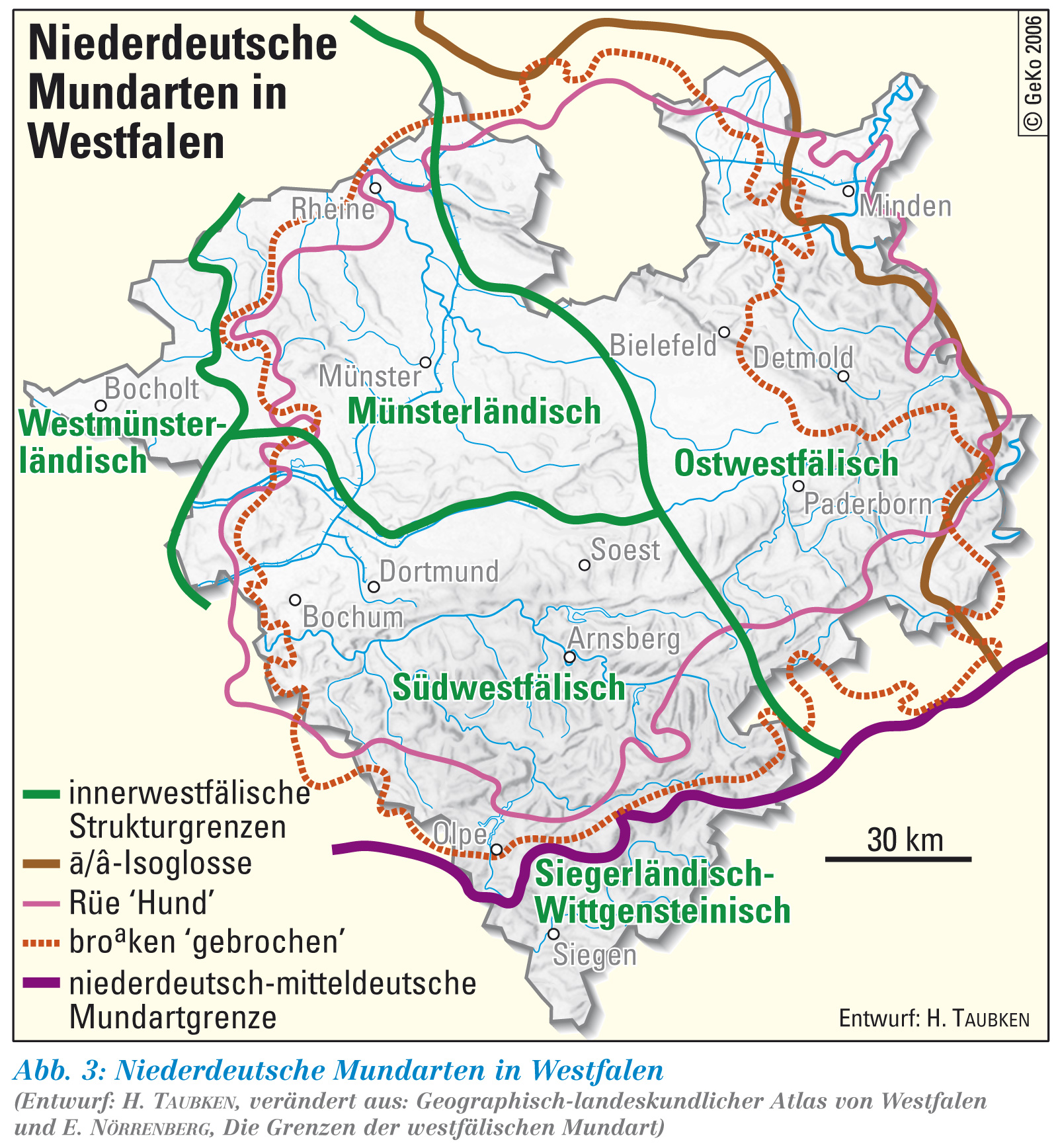
The traditional dialect is the East Westphalian variant of the Low German language . The Wiehengebirge hardly has the function of a dialect border , as it is partially used in other low mountain ranges. On the one hand, the mountains are considered to be the boundary between the “Ravensberg dialect” and Mindischen , on the other hand there are greater differences to the Osnabrück dialect, so that the dialect borders also cross the mountains.
The Widukind myth
Comparable with other low mountain range regions in Central Europe, legends and myths also developed in the area of the Wiehengebirge , the focus of which is in particular the historically verifiable person of the Saxon Duke Widukind (also known as Wittekind in the vernacular ). The Widukind cult began as early as the 12th century in nearby Enger , where Widukind's grave slab with inscription was made around 1100 and he began to be celebrated as King of Engerngau. The fact that the legendary Duke is buried in Enger was first mentioned in the 13th century. In 1377, Emperor Charles IV paid a visit to the grave and had the tomb renewed at his own expense.
In the Wiehengebirge area there are numerous toponyms with reference to Widukind, such as B. the Wittekindsburg , the Wittekindsberg and three Wittekinds springs . The ridge path on the Wiehengebirge, known as Wittekindsweg , bears his name, as does the Wittekind high school in Lübbecke and the Widukind high school in Enger.
At the federal highway 30 , a stylized representation of the mountains with the Prince of Saxony indicates the special relationship between the region and Widukind.
Open air theaters
Three open-air theaters use the natural ambience of the Wiehengebirge: the Goethe open-air theater Porta Westfalica on Wittekindsberg in the Barkhausen district , the Nettelstedt open-air theater on Nettelstedter Berg in Lübbecke- Nettelstedt and the Kahle Wart open-air theater on the Kahler Wart in Hüllhorst- Oberbauerschaft .
traffic
South of the Wiehengebirge between Osnabrück and Bad Oeynhausen runs in a west-east direction, the federal motorway 30 , which connects to the A 2 in the east, connections to the A 33 and A 1 in the west , with the latter running in a north-south direction the furthest west cuts through the mountains.
At Porta Westfalica , east of the Wiehengebirge, it is affected by federal highway 61 . The B 65 runs north of the mountains in a west-east direction , the B 51 crosses the western part of the mountains . The B 68 and B 218 run in the far west . Numerous state and district roads compact the road system.
The ICE route Hamburg-Cologne via Osnabrück and the RB 71 Ravensberger Bahn from Bünde to Rahden cross the Wiehengebirge as railway lines . The Löhne – Rheine railway line runs parallel to the ridge to the south and the private Wittlager Kreisbahn to the north via Bohmte - Bad Essen - Preußisch Oldendorf , which is used for freight and museum traffic on a section .
Traffic history

The Wiehengebirge has always influenced the course of trade and military roads: on the one hand, it was a traffic obstacle for movement from north to south, on the other hand, the early-populated open part of its northern roof provided space for an east-west connection between the mountain forest in the south and the swamp in the North. In the course of the Lübbeck Loessland, the medieval military road Minden-Osnabrück ran , which today corresponds to the western section of federal road 65. The Bremer Heerweg crosses the Wiehen Mountains about 500 m west of the Schnippenburg . This traffic route connected the cities of Osnabrück and Bremen in the Middle Ages and in the early modern period . In Osnabrück it had a connection to Frankfurter Heerstrasse , which opened up the north-west Hessian area via Paderborn and the Sauerland .
The railway line from Bünde via Lübbecke was inaugurated on September 30, 1899. It cuts through the Wiehengebirge in a cut in the terrain, the breakthrough valley of the Great Aue. Further south, the rails run along a dam, separating the Auetal from the Wiehengebirgswald. The river bed of the floodplain was moved to the west. In 1986 the stop at Neue Mühle was given up, today there is only one stop on demand.
The Wallücker Willem (actually: Wallückebahn) was a small railway operated from 1897 to 1937 from Kirchlengern in the Werre Valley up to the quarry at the Wallücke pass (district Oberlübbe of the Hille community ). It had a track width of 600 mm and served not only to transport goods but also to transport people.
Crossing the Wiehengebirge


Despite its comparatively low absolute height, the Wiehengebirge is a traffic obstacle. Currently there are only 21 public transport roads between Porta Westfalica and Bramsche that cross the mountains. The crossing roads run either along the river breakthroughs or as pass roads in the course of the villages; the latter are occasionally impassable or blocked as a precaution in winter when snow falls or freezing rain.
| passport | comment | Pass height [m above sea level NHN] | Pass road | Traffic density |
|---|---|---|---|---|
| Green lake | - | 182 m | K 203 | - |
| Bald wait | - | 249 m | K 60 | 4,049 vehicles / d |
| Horst height | Luebbeck mountain | 214 m | B 239 | 15,522 vehicles / d |
| Bergstrasse Nettelstedt | called Mount of Olives | 206 m | L 803 (NRW) | 2,703 vehicles / d |
| Wallücke | - | 152 m | L 876 (NRW) | 6,510 vehicles / d |
| Bergkirchen | - | 165 m | L 772 (NRW) | 5,468 vehicles / d |
| Lutternsche Harrow | - | 214 m | K 30 | 2,233 vehicles / d |
West of the Hunted breakthrough, the pass height of the roads is usually well below 150 meters. Due to the topography there, the Wiehengebirge is no longer a significant obstacle to traffic.
| place | comment | Height [m above sea level NHN] | Street |
|---|---|---|---|
| Barkhausen | Breakthrough valley of the Hunte | approx. 80 m | L 83 (Ns) |
| New mill | Breakthrough valley of the Great Aue | approx. 80 m | L 557 (NRW) |
| Porta Westfalica | Breakthrough valley of the Weser | approx. 50 m | B 61 |
literature
- Friedhelm Pelzer: Location and natural area of the Minden-Lübbecke district. In: Carola Bischoff et al. (Ed.): District of Minden-Lübbecke. (= Cities and municipalities in Westphalia. Volume 13.) Published by the Geographical Commission for Westphalia . Aschendorff Verlag, Münster 2013. pp. 8–35.
- Bernhard Pollmann: Teutoburg Forest with Egge and Wiehen Mountains. 50 tours . 3rd edition, Munich 2006, p. 84
- Karsten Mosebach ; Florian Möllers: On quiet paths: Forays through the Geo.Naturpark in Osnabrücker Land , Teutoburg Forest and Wiehengebirge . Meinders and Elstermann, Belm near Osnabrück 2002, ISBN 978-3-88926-889-1 (112 pages).
Web links
References and comments
- ↑ Geological Survey North Rhine-Westphalia: Most important geotopes - Weser breakthrough at Porta Westfalica. online ( Memento from April 8, 2015 in the Internet Archive )
- ↑ Jürgen Spönemann: Geomorphological investigations on layer ridges of the Lower Saxon mountainous region. (= Göttinger Geographische Abhandlungen. Heft 36) Göttingen 1966.
-
↑ Various authors: Geographical Land Survey: The natural space units in single sheets 1: 200,000 - Federal Institute for Regional Studies, Bad Godesberg 1959–1970 → Online maps
- Sheet 83/84: Osnabrück / Bentheim (Sofie Meisel 1961)
- Sheet 85: Minden (Sofie Meisel 1959)
- ^ Chamber of Agriculture North Rhine-Westphalia: Agriculture in the region of the Minden-Lübbecke district office
- ↑ KH Photo, Das Wiehengebirge accessed on July 26, 2018
- ↑ Impressive pictures of fog over the Ravensberger Mulde and the Wiehengebirge protruding from the fog: image 1 , image 2 , image 3
- ↑ Jochen Farrenschon & Horst Klassen: Law. In: Geology in the Werser and Osnabrück Mountains. Geological Service NRW, Krefeld 2003, pp. 57–73.
- ↑ Günter Drożdżewski: Geological development and tectonic construction. In: Geology in the Werser and Osnabrück Mountains. Geological Service NRW, Krefeld 2003, pp. 16–30, here pp. 28–29.
- ^ Wilhelm Dienemann : Explanation of the sheets Melle, Quernheim, Oeynhausen. Geological map of Prussia. Delivery 347. Berlin 1939, pp. 10-11.
- ^ Wilhelm Dienemann : Explanation of the sheets Melle, Quernheim, Oeynhausen. Geological map of Prussia. Delivery 347. Berlin 1939, p. 69.
- ↑ Karl-Heinz Otto: How the foundlings came to Westphalia! (LWL - Geographical Commission for Westphalia)
- ^ Geological Service North Rhine-Westphalia ( Memento from April 8, 2015 in the Internet Archive )
- ↑ The height of the Nonnenstein is sometimes incorrectly given as 325 m. example
- ↑ Excursion guide to eight soil profiles in the Preußisch Oldendorf region, "Soils" map, p. 3 ( Memento from February 6, 2011 in the Internet Archive ) (PDF; 8.2 MB)
- ^ Wilhelm Dienemann : Explanation of the sheets Melle, Quernheim, Oeynhausen. Geological map of Prussia. Delivery 347. Berlin 1939, p. 69.
- ↑ The history of the bifurcation in Gesmold. Heimatverein Gesmold, accessed on November 24, 2017 .
- ↑ Werner Trautmann: Explanations for the map of the potential natural vegetation of the Federal Republic of Germany 1: 200000 sheet 85 Minden. (= Writings for Vegetation Science, Book 1). Federal Institute for Vegetation Science, Nature Conservation and Landscape Management. Bad Godesberg 1966. pp. 76-77.
- ↑ Dieter Schnase: Storm-proof cuttings. o.Ang. (PDF; 96 kB)
- ^ Nils Beinke: Zapfenstreich in Wiehengebirge. New Westphalian August 10, 2009.
- ↑ duenne-info.de: duenne-info.de The “Dünne” hunting area.
- ↑ Search areas for crossing aids in the low mountain ranges, p. 78 LANUV 2012.
- ↑ pilzfreundetreff.de: Mushroom seminars in the region: Bünde-Löhne-Enger
- ↑ Landscape profile Eastern Wiehengebirge Meesdorfer Heights of the Federal Agency for Nature Conservation ( information )
- ↑ Wiehengebirge landscape profile of the Federal Agency for Nature Conservation ( information )
- ^ "Gehle" nature reserve in the specialist information system of the State Office for Nature, Environment and Consumer Protection in North Rhine-Westphalia
- ^ Meyers Konversations-Lexikon from 1888, peter-hug.ch
- ^ Lexicon from 1888 peter-hug.ch
- ^ Heinrich Rüthing: The beginnings of religious life on the Wittekindsberg according to the written sources (PDF). (PDF) Retrieved April 23, 2014 . , P. 45.
- ^ Pierer's Universal Lexicon from 1857 zeno.org
- ↑ welt.de Welt.de: Pale-bones-in-the-fog .
- ↑ Dankwart Guratzsch: New dispute about the location of the Varus Battle welt.de October 16, 2008
- ↑ Heimatbund Osnabrücker Land: Belm. Retrieved April 23, 2014 .
- ^ Relict.com: Air tank storage 2 / VI Preußisch Oldendorf. Retrieved April 23, 2014 .
- ^ Relict.com: Nike FlaRak position Bad Essen. Retrieved April 23, 2014 .
- ↑ Statement from the Deutschland Tourismus website ( memento of October 5, 2007 in the Internet Archive ) (PDF)
- ↑ Overview of health resorts in Lower Saxony ( Memento from July 1, 2010 in the Internet Archive )
- ↑ Wittekindsburg special landing site, accessed on November 29, 2017
- ↑ klettergebiet-info.de Wiehengebirge ( Memento from April 16, 2009 in the Internet Archive )
- ↑ City of Lübbecke: Land use plan (PDF)
- ^ Teutoburgerwald.de: Kaiser Wilhelm monument at Porta Westfalica in the mill circle . Retrieved April 23, 2014 .
- ↑ garmin-download.de: Wittekindsweg p.18 (PDF; 147 kB)
- ↑ Website of the Landesbetrieb Wald NRW ( Memento from December 31, 2010 in the Internet Archive )
- ↑ Integrated rural development concept (ILEK) for the Minden-Lübbecke mill district, chap. 4 (PDF; 668 kB)
- ^ Lower Saxony Chamber of Agriculture: Forestry Office Weser-Ems
- ↑ Lower Saxony Forestry Office Ankum
- ↑ District foresters of the Lower Saxony Forestry Office Ankum ( Memento from July 25, 2014 in the Internet Archive )
- ^ Holsing Vital GmbH: Chronicle
- ^ Hermann Jellinghaus : Westphalian grammar. The sounds and inflections of the Ravensberg dialect with a dictionary. Second edition, Norden 1885, pp. 1–2. dig
- ^ LWL: Low German dialects in Westphalia.
- ↑ Sebastian Möllers: The Schnippenburg in the focus of archeology. Archeology.online
- ↑ Newspaper report on the road closure of the Wiehengebirge passes