Donoer Berg
| Donoer Berg | ||
|---|---|---|
|
Overlooking the mountain of Donoer Schwenningdorf from |
||
| height | 243 m above sea level NN | |
| location | Rödinghausen , North Rhine-Westphalia , Germany | |
| Mountains | Wiehengebirge | |
| Coordinates | 52 ° 15 '44 " N , 8 ° 32' 39" E | |
|
|
||
| rock | Sandstone | |
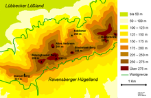
The Donoer Berg is a mountain in the Wiehengebirge near Bieren -Dono and belongs to the municipality of Rödinghausen in the Herford district in North Rhine-Westphalia . The Gewinghauser Bach and the Klosterbach have their source at Donoer Berg . An abandoned sandstone quarry is located in the immediate vicinity of the summit.
The mountain has an elongated ridge and reaches a maximum height of 243 m above sea level. NN . To the west it slopes down to the breakthrough valley of the Great Aue . In the east the Wiehengebirge rises even further to Glösinghauser Berg at 289 m above sea level. NN at.
The Wittekindsweg leads over the summit ridge .
Horse paddocks at the Auenquelle stud . View of Donoer Berg.
From Masch mountain of


