
Rödinghausen
| coat of arms | Germany map | |
|---|---|---|

|
Coordinates: 52 ° 15 ' N , 8 ° 29' E |
|
| Basic data | ||
| State : | North Rhine-Westphalia | |
| Administrative region : | Detmold | |
| Circle : | Herford | |
| Height : | 135 m above sea level NHN | |
| Area : | 36.27 km 2 | |
| Residents: | 9758 (Dec. 31, 2019) | |
| Population density : | 269 inhabitants per km 2 | |
| Postal code : | 32289 | |
| Primaries : | 05746, 05223, 05226 | |
| License plate : | HF | |
| Community key : | 05 7 58 028 | |
| LOCODE : | DE RGU | |
| Community structure: | 5 districts | |
| Address of the municipal administration: |
Heerstrasse 2 32289 Rödinghausen |
|
| Website : | ||
| Mayor : | Ernst-Wilhelm Vortmeyer ( SPD ) | |
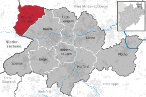
| Location of the community of Rödinghausen in the Herford district | ||
 .svg) |
||


Rödinghausen ( Low German Ränghiusen ) is a municipality in the northeast of the German state of North Rhine-Westphalia , around 30 kilometers north of Bielefeld . With almost 10,000 inhabitants, Rödinghausen is the smallest municipality in the East Westphalian district of Herford ( Detmold administrative district ). In its current boundaries, it was created in 1969 by amalgamating five previously independent locations in the Rödinghausen district. Settlement in the fertile Ravensberger Land can be documented in writing as early as 851.
geography

Geographical location

Rödinghausen is located on the southern edge of the Wiehen Mountains in the Ravensberg hill country . The closest major cities are Bielefeld, 30 km south, and Osnabrück 32 km to the west. The ridge of the Wiehengebirge mainly forms the northern border of the municipality; a very small part of the Eggetal (Gehle) still belongs to Rödinghausen, but, strictly speaking, lies north of the Wiehengebirgskamm. The Nonnenstein in the northwest of the community is 274 m above sea level. NN the highest elevation, in the extreme northeast the Dono mountains in the municipality reach a height of 243 m above sea level. NN . A little northeast of the municipal boundary, the mountains rise further to a summit height of 289 m above sea level. To reach NN . From north to south the Wiehengebirge slowly runs out. The Else valley is 68 m above sea level. NN represents the deepest valley in the community. The church in the Rödinghausen district is 150 m above sea level. NN height.
Waters

Numerous smaller streams run through the municipality and mainly flow towards the Else, which partly forms the southwestern municipality boundary and flows through the municipality from west to east for a few hundred meters. The largest tributary of the Else in the municipality is the Kilverbach or Kollbach, which partially forms the western border of Rödinghausen. Part of the streams in Bieren and Schwenningdorf drains north of a barely noticeable watershed into the Great Aue , which rises in Bieren and is still called Neuer Mühlenbach in Rödinghausen . In contrast to the Else, the Große Aue does not flow south of the Wiehengebirge towards the Weser , but north. The Große Aue leaves the municipality in the direction of Holzhausen through a breakthrough valley of the Wiehengebirge that it created itself in the Neue Mühle district . Before the breakthrough, the Große Aue also flowed south. In the east, the Gewinghauser Bach drains parts of Dono and flows into the Else. The southern Bieren, Schwenningdorf and Ostkilver are drained by the Darmühlenbach , which flows south and also feeds the moat of Gut Böckel. In the extreme north-west, a small part of the streams in the Wiehengebirge drains over the Green Lake into the Hunte .
geology


A distinction must be made between the altitude of the Wiehengebirge and the flatter areas in the south of the municipality, which naturally belong to the Ravensberger Mulde and include the Elsetal.
The comb-like Wiehengebirge is an elongated, wooded mountain range, which consists of narrow, wooded harrows , which are separated from each other by passes and breakthrough valleys (Dören) , for example the valley of the Great Aue. In Rödinghausen the ridge layers consist of the hard and light Wiehengebirge sandstone from the time of the Upper Jura or Malm. To the south, the Heersumer layers (sandstone from the Jura), ornate clays and the Cornbrash sandstone , a limestone-bound sandstone , from the Middle Jura or Dogger are lined up . In Bieren-Dono, the sandstone was quarried in a quarry that has since been abandoned. On the steep and rocky slopes, the vegetation is limited to beeches and undemanding grasses, semi-grasses and mosses. The numerous brooks arise in moist spring hollows, first flow down the slopes in V-valleys (Siepen) and then meander through the wider sole valleys such as the Wehmerhorster Wiesental in Schwenningdorf .
The majority of the community belongs to the Ravensberger Mulde . The Ravensberger Mulde is a gently undulating, between 50 and 140 m above sea level. NN lying hill country . The most characteristic features are the box valleys (so-called sieves ) formed by human hands , which often cut suddenly and deeply into the otherwise poorly contoured land. The V-valleys that were characteristic before the creation of the Sieke are only preserved in the forest areas (e.g. in Vossholz). The subsoil consists of impermeable lias slabs (clay slate), which were deposited on the sea floor around 180 million years ago and contain fossils such as ammonites , snails and mussels. The clay seldom emerges and is mined for a brick factory in West Kilver. During the Vistula cold period, a layer of loess up to five meters thick was deposited on top in Rödinghausen . Loess is a porous, moisture-storing, light and easy-to-work brown earth, which is quite poor in lime due to leaching and has many boulders from the Ice Age, but overall it is one of the most fertile arable soils. The Elsetal forms the glacial valley of the Else- Werre- Niederung (Osnabrück Valley) , which extends from Osnabrück to Porta Westfalica . The fertile loess was washed away from the lower terrace on both sides of the Else and sand, loam and rubble (terrace gravel) was washed ashore. In some cases, however, the old valley floor, the ground moraine or Lias claystone come to light. A floodplain stretches along the Else. Before it was straightened and dyed, it was regularly inundated by the meandering river in front of it and is therefore covered by a layer of clay up to two meters thick.
Rödinghausen is largely mediocre, towards the north in higher elevations it is increasingly better to very good for the use of geothermal heat sources by means of a geothermal probe and heat recovery through heat pump heating (see the map on the right).
Expansion and use of the municipal area


The community area is 36.27 square kilometers. The maximum north-south extension is about 7.9 km (from Bruchmühlen to Rödinghausen-Gehle), the maximum west-east extension is about 7 km (from Rödinghausen-Kilverbachtal to Bieren-Dono).
Larger forest areas are located in the north on the slopes of the Wiehengebirge in the districts of Rödinghausen, Schwenningdorf and Bieren; There is a natural forest community of an oak - hornbeam forest . However, the area of the municipality is only sparsely forested because the flatter parts of the municipality are mainly used for agriculture . The only notable forest is the Vossholz around Gut Böckel. The soils are fertile due to the loess soil . In the small-scale fields, mainly grain and maize, but also increasingly rapeseed, are cultivated. The damp sieves are used as pastureland. The following table shows the exact land use.
| Area according to type of use |
Settlement and traffic areas |
Agricultural area |
Forest area |
other open spaces |
|---|---|---|---|---|
| Area in hectares | 797 | 2298 | 501 | 29 |
| Share of total area | 22.0% | 63.4% | 13.8% | 0.8% |
Neighboring communities
Neighboring communities are the middle center of Bünde in the south-east, Lower Saxony's Melle in the west and south-west and the Prussian Oldendorf belonging to the Minden-Lübbecke district in the north on the other side of the Wiehen Mountains. In the south, the Else separates the Bruchmühlen district of Melle in Lower Saxony from the Bruchmühlen district of Rödinghausen in North Rhine-Westphalia. There is also a very short border with the municipality of Hüllhorst in the Minden-Lübbecke district. This border runs in the Bieren-Dono area in the extreme northeast of the Rödinghausen community.
Community structure
Rödinghausen consists of five localities that formed independent municipalities until the municipal territorial reform that came into force on January 1, 1969. The largest district in terms of inhabitants is Bruchmühlen in the south-west ( West Kilver until 1969). The administrative center of Rödinghausen is in the northwest, the Schwenningdorf district in the north and the largest district in terms of area Bieren in the northeast. In the southeast of the municipality is the district of Ostkilver. The following table gives an overview of the population and the area:
| District | Residents | surface |
|---|---|---|
| Rödinghausen | 1,644 | 4.554 km² |
| Curd mills | 3,378 | 6.798 km² |
| Beers | 1,299 | 9.544 km² |
| East Kilver | 1,876 | 7.926 km² |
| Schwenningdorf | 2,356 | 7.449 km² |
| total | 10,553 | 36.27 km² |
climate

Rödinghausen is located in the temperate climate zone of Central Europe. The climate is determined by the west wind drift , the location of Rödinghausen in the oceanic-continental transition area of Central Europe and its relative altitude at 150 m on the Wiehen Mountains. The average annual temperature in Rödinghausen is 8.5 ° C. The warmest months are July and August with an average of 16.7 and 16.3 ° C and the coldest January and February with 0.3 and 0.8 ° C on average. Most of the precipitation falls in August with an average of 82 millimeters, the lowest in February and April with an average of 52 millimeters. The monthly amount of precipitation fluctuates only slightly and despite the 201 days with more than 0.1 millimeters of precipitation, the total amount of 751 millimeters is below the German average. On a long-term average (1961–1990) the region had an average of 1473 hours of sunshine per year (observation station: Herford). The overall climate of Rödinghausen can be described as a mild, low mountain range climate. Due to the relative altitude of Rödinghausen, the annual average is up to 1 ° C colder than in nearby Herford or up to 0.5 ° C colder than in the Elseniederung. It can happen that it snows in the north of the municipality but rains in the south. Overall, however, the winters are mild and the summers moderately warm. The prevailing winds come from the west or south-west and bring regularly distributed rainfall from the Atlantic throughout the year . In summer, however, the amount of rain is somewhat greater than in winter. However, because of these winds, there is no extreme incline rain , such as. B. on the windward side of the Teutoburg Forest . Rather, the large-scale border through the Wiehengebirge (north), Osning (south) and Meller Berge (east) leads to a climate that has less precipitation than Herford. The difference is about 50 millimeters per year. So there is a humid climate all year round . The table below shows an overview of the long-term average climate data.
|
Average monthly temperatures and precipitation for Rödinghausen
Source: Shaker
|
||||||||||||||||||||||||||||||||||||||||||||||||||||||||||||||||||||||||||||||||||||||||||
→ See also: Climate in Ostwestfalen-Lippe
history

The history of the area, which today comprises the community of Rödinghausen, was determined less by significant individual events than by long lines of development that often went hand in hand with changes in the livelihood of the residents. Therefore, in the following, the story is presented primarily on the basis of these lines of development. The history of today's municipality of Rödinghausen does not begin until the municipal regional reform in 1969, when Rödinghausen was created from five independent municipalities of the former Rödinghausen office, which in turn existed as an independent unit from 1888. However, the individual districts are much older.
Origins and Saxon settlement until 804
Rödinghausen is part of the cultural landscape of the Ravensberger Land . Due to the fertile loess soils, it belongs to the old settlements . Settlement can be documented in writing until the early Middle Ages , but there are also much older traces of settlement. The finds of stone axes and spearheads suggest that the area was settled by hunters and fishermen as early as the early Stone Age (5000–2000 BC). According to the Roman historian Tacitus , the area was settled by the Cherusci at the turn of the ages (1-400 AD) . At the time of the Great Migration (400–500) these tribes were displaced by the Saxons . The Saxon tribe of the Engern (cf. also Enger ) was at home in what is now the municipality . Presumably the Engern exercised their Germanic belief in gods in a cult site on the hill on which today's church in Rödinghausen stands.
Franconian rule and the Middle Ages until 1450

When the Engern, under their Duke Widukind, were defeated by the Franks under Charlemagne in a war from 772 to 804 , they had to give up their faith. They were forcibly baptized and a first wooden church was built around 850 on the former cult site in Rödinghausen. The Franks sat in the conquered territories Gaugrafen one who managed it for the territory of their royal courts of. One of these royal courts was the Rödinghauser Haus Kilver (then called Villa Kilveri ), which was first mentioned in a document in 851 a few decades after its presumed origin and is therefore the oldest recorded settlement core in Rödinghausen. In this document, Ludwig the German gave the Kilver house to the women's monastery founded in Herford around 822 under Ludwig the Pious . Schwenningdorf was first mentioned in writing in 1088 in a pamphlet by the Osnabrück bishop . The place was probably called Swanekindorp after its founder Swanekin. The then still tiny towns of Bieren (at that time still Beren with four courtyards), Kilver (Kelver, three courtyards) and Rödinghausen (one Meierhof , two courtyards) were mentioned in later levers of the monastery on the mountains near Herford . Rödinghausen, which was first mentioned in 1147, was named after its founder Rhoderat initially Rhode Wolfratshausen. Another assumption is that it was named after Count Hrodrad from Grönegau in today's Melle . The suffix -inghausen denotes a location in a mountain forest. In 1150, Ostkilver was also mentioned in a sales contract between the Osnabrück bishop and Count of Tecklenburg . Beer was first mentioned in the 12th century. Beer is derived from beara and describes a forest that is rich in fruits. West Kilver was only mentioned in a lifting role of the Herford monastery in 1308 and is officially the youngest part of the community.

From these farmers the five current districts of Bieren, Schwenningdorf, Rödinghausen, Ostkilver and Westkilver developed over time. The largest church in Rödinghausen, St. Bartholomäus , which probably emerged from the wooden church of the Engern, was mentioned in writing for the first time in 1233. It initially belonged to the sphere of influence of the Bishop of Osnabrück or as patronage to Herford Abbey. The church became Protestant around 1533, at least this year is the first time that several Rödinghauser clergymen with children and wives are reported. The second surviving manor next to the Kilver house, Gut Böckel , was first mentioned in 1350. The third knight's seat , Gut Waghorst in Bieren, was first mentioned in 1349, later served as the seat of the Rödinghausen office from 1888 to 1907 and was later demolished.
The people in Rödinghausen lived almost exclusively from agriculture and livestock and forestry. Around 800 the Rödinghauser lived in settlements surrounded by dense forest, so-called Drubbeln , which were about two kilometers apart. A drubbing consisted of up to ten yards. In Rödinghauser area there were the Drubbel Rödinghausen, Schwenningdorf, Siendorf (in today's district Schwenningdorf), Bieren, Dono (in today's district Bieren), Ostkilver and Westkilver. The drubbing was a little higher, but in the immediate vicinity of the damp lowlands. The middle slopes around the Drubbel were originally cultivated without crop rotation and were divided into strips about 500 meters long and about twelve meters wide. The fields were fertilized by pests. This form of fields is called long- striped ash , where Esch comes from Germanic and means to eat . The parcels had an almost S-shaped shape adapted to the terrain and were accessible from the narrow side. The strips were each assigned to a farm and were initially cultivated by this; after the grain harvest, however, the Esch was jointly used as stubble pasture. The farms themselves were inherited undivided by the youngest descendants. Pigs were kept in the forest and fed on acorns and beechnuts. The peasants had to pay dues to the noble landowners or the Herford monastery, the so-called tithe , if they were not serfs of the landowners or the monastery to varying degrees .
Since only the youngest descendant ever inherited the farm, the other descendants, the hereditary gods , had to build their own farms near their parents' farm from around the year 1000. In the best case scenario, the Erbkötter inherited only a fraction of the parental property or rights to work the Esch. Around the Drubbel, the hereditary animals - but later also the heirs themselves - created new farmland through clearing. The battle floor (or block floor ) was chosen as the hallway shape . In this type of corridor, the areas were divided into irregular, block-like polygons and were no longer used jointly. Access to the fields was no longer possible uniformly from the narrow side (as with the Esch). In the course of this farmland expansion, individual courtyards were created apart from the old drubbing. In addition, individually lying Meierhöfe were built , which were characterized by their large property and took on certain tasks for the feudal lords. For example, they often collected the tithes of the remaining farmers. One of the oldest of these Rödinghauser Meierhöfe is Hof Steinmeyer in Rödinghausen, which has been evidently inhabited by the Steinmeyer family (Stencampe) from at least 1319 until today.
Linen weaver time until 1860

From around 1450 to 1650, small agriculturally used ridges ( broad stripes ) and small, individual ridges (Markkotten) off the Drubbel were built in the common Mark (the forest between the ash trees and blockures) . This is where the Markkötter lived , who, in contrast to the Erbköttern and heirs, received no or only a very small share of inheritance and whose settlement in the Mark was tolerated, but was viewed with suspicion by the Erbköttern. The property of the Markkötter was small and their livelihood was mainly based on their cattle, which they kept in the forests of the common Mark, although this right was only grudgingly granted them by the established farmers. The fact that they were allowed to do this can only be explained by the pressure of the brand owners ( Erbexen ), who also demanded fees from the marrowmakers. The formerly dense marrow forests have been decimated by the “wild” settlement of the marrow kotters and are often not systematically reforested. Since the 16th century the heuerlings formed another group of settlers. They did not inherit any property at all, but had to live in rented cottages (heuerlingskotten). Like the farm of the farmer to whom the Kotten belonged, which was within shouting distance, they had a small deele, garden and stable. The hired people had to pay the rent partly in the form of work on the farm. With the growing population, however, neither Markkötter nor heuerlings had sufficient income opportunities.
These poorer social groups therefore opened up a new way of earning a living in the 15th century with the cultivation of flax and its processing into linen . This early form of industrialization in the Ravensberger Land is characterized as proto-industry . The linen weavers - above all poor heuerlings and kötter - always processed the flax when they were not working in their own fields or in the fields of their Kotten owner, into the well-known Ravensberger linen, the z. B. Bielefeld later owes the nickname Leineweberstadt . Weaving and spinning rooms in the Rödinghausen farms were part of everyday life. The spinning house communities stretch the flax into yarn in winter , which is then woven into bed and table linen. Some of the bales were brought to Herford or Bielefeld for sale on foot, because Rödinghausen was not connected to the rail network until 1856 (Bad-Bentheim-Minden route) or 1899 (Ravensberger Bahn). A typical weaving room can be seen today in a small exhibition at Gut Böckel . The heuerlings leased land to grow flax, but the heirs and Markkötter also grew flax. In Prussian times (from 1614) the linen trade was promoted to increase tax revenue ( mercantilism ) and the number of hired people grew rapidly, so that around 1700 the rural population in Ravensberger Land already consisted of two thirds of hired people. In 1770 the mark was completely privatized under Prussian pressure and largely turned into arable land for small farms (sites). The large estates initially received the greater part of the mark, in line with their previous property. However, they could no longer manage them sensibly and therefore ceded them to the same small farmers. These smallholder ownership structures lasted until the 1950s. The sieves were widened during this time in order to create pasture for the cattle that had previously grazed in the marrow.
In the time of the linen weavers from the 14th century to 1609, the area belonged to the County of Ravensberg . It was controlled from Limberg Castle , the seat of the Limberg Office, by the counts, who were the secular rulers and, in addition to the king, who was represented by the monastery in Herford, feudal lords of the area. In 1647 the county fell to Brandenburg-Prussia after it was controversial and fought over in the Thirty Years War. Since then Rödinghausen has been Prussian territory almost continuously and from 1719 part of the Prussian administrative unit Minden-Ravensberg . Until 1806, today's municipal area belonged to the Limberg Office , which, however, after the castle was razed around 1695, was initially administered by Holsen , later from 1771 by Börninghausen and even later by Bünde . From around 1722, however, the power of the aristocratic lords faded and with it the obligation to submit a tithe . From 1807 to 1811 Rödinghausen was for a short time part of the Kingdom of Westphalia de facto French territory and the landowner of Kilver was Maire (mayor) of the Rödinghausen mayor in the canton of Bünde. From 1811 to 1813 the area was added to the French Empire. For the peasants, the French rule opened up the possibility of buying themselves out of the feudal relationship and serfdom with a fixed payment. However, the hirelings remained economically dependent on their landlords for a long time, even though they were no longer legally bound to nobles. After the end of the Napoleonic era , which was finally fought for in the Battle of Waterloo with Rödinghauser's participation, Westphalia fell back to Prussia and Rödinghausen became part of the newly created district of Bünde in the province of Westphalia in 1816 . This went on in 1832 in the Herford district . In 1816 Rödinghausen was still referred to as the parish of Rödinghausen and from 1843 as the office of Rödinghausen, which included today's districts as independent communities.
Cigar maker time until 1945

Until 1888, the Office Rödinghausen was administered in personal union with the Office Bünde from Bünde and then as an independent Office Rödinghausen. The official seat of Amtmann Meier was initially the leased Waghorst estate until 1907, then a newly built administrative building in the Rödinghausen district, which was the first administrative seat.
With the advent of industrialization and mechanical looms in England , the Rödinghauser linen weavers were no longer competitive. In Germany mechanical looms were only installed in the spinning mills of large cities such as Bielefeld (e.g. Ravensberger Spinnerei ). The greatest threat to linen weavers, however, was mechanically produced export linen, which came from England or Belgium from around 1820 onwards . In the following 20 years of hunger, which were also caused by bad harvests, some Rödinghausers became smugglers in their distress, because from 1836 to 1856 Prussia and thus also the area of today's Rödinghausen belonged to the German Customs Union , but not the area of the House of Hanover - So today's neighboring communities in Lower Saxony. During this time, a flourishing smuggling industry developed between the towns of Düingdorf ( Lower Saxony ) and West Kilver , bringing silk, sugar, butter, salt and coffee across the green border. Other people in need emigrated, e. B. in today's twin town Pemberville , Ohio .
An upswing was only achieved through tobacco processing . When Tönnies Wellensiek began producing cigars in nearby Bünde (later known as the cigar town of Bünde ) and the first cigar factories were established, branches were also set up in Rödinghausen . After around 20 years of starvation, many Rödinghausers began handcrafting cigars from around 1860 . Many families who were still skilled in the processing of flax worked in stalls or cut, rolled and pressed the cigars at home. Heuerlings freed themselves from the economic dependency of their peasants by becoming factory workers.
In honor of the emperor , a war memorial was erected at the Rödinghauser church in 1890, which testified the enthusiasm of many Rödinghausen citizens for the empire, which also lasted beyond the First World War . In 1911, a memorial was erected next to the observation tower on the Nonnenstein for Reich Chancellor Bismarck , who was loyal to the emperor . However, the Reichstag elections in 1903 and 1912 showed that the Social Democrats also had a broad following among factory workers . In 1912, SPD candidates received 35.6 percent of the vote.
Mobilization began in Rödinghausen in 1914 and there are various reports about the enthusiasm for the war among the Rödinghausen residents. Those who stayed at home were only slightly affected by the war, and the black market ensured the supply situation almost as in peacetime - at least for the rural population, who bypassed rationalization, produced food, traded "black" among each other or sold it to townspeople. Of the 704 Rödinghausen soldiers who participated in the war, 76 died, 72 were wounded, 14 captured and 10 went missing. A war memorial was dedicated to them in 1919 in East Kilver.
After the war, most Rödinghausers found it difficult to accept the emperor's abdication, although a workers 'and soldiers' council was founded in Rödinghausen in 1918 - officially to maintain order. The imperial busts remained in the public buildings until 1922; Until 1926, the Amtssparkasse still had an imperial seal, and it was not until 1928 that the reluctantly acquired black, red and gold flag, symbol of the new democratic order, was affixed to the office, and only under pressure from the Prussian government president and the SPD. Local group Schwenningdorf, which was the first Rödinghauser institution to hoist the new flag. The young democracy never really caught on in Rödinghausen, and so many Rödinghausers welcomed the return to the old flag in imperial colors after the Nazis came to power in 1933.
In the last Reichstag elections in the 1930s, the political spectrum in Rödinghausen was divided. On July 31, 1932, the SPD and KPD together received 34.6 percent of the vote, the right-wing parties NSDAP and DNVP together 62 percent, i.e. the absolute majority that they initially missed in Rödinghausen in the election on September 14, 1930. The Reich President Hindenburg , who was very much in favor of the monarchy , received 72.3 percent of the votes in the election as Reich President in 1925, but parts of the conservative (monarchist) -minded Rödinghauser voters went over to Adolf Hitler by 1932 . April 1932 already received 56.6 percent (Hindenburg: 41.4 percent) of the vote. When the Nazis came to power, social democratic groups and other associations that the Nazis did not like were also established in Rödinghausen. a. Gymnastics clubs, prohibited. The places received local group leaders , many Rödinghausers joined the NSDAP and homes of the Hitler Youth were opened in Rödinghausen and West Kilver . Overall, however, the enthusiasm of the Rödinghauser rural population for National Socialism was limited to an unreflective follower , as the community historian Rolf Botzet judges. Even the anti-Semitism did not fall on fertile ground in office, especially in Rödinghausen since 1905 no Jewish citizens dead. The only hint of anti-fascist resistance came in 1935, when the former Rödinghauser pastor Ludwig Müller , who had meanwhile been appointed Reich Bishop , intended to hold a service in his old place of work, but stood in front of the closed Church of St. Bartholomew on the scheduled day. Pastor Beckmann had taken the key or hidden it, and the Reich Bishop was informed that the pastor had gone for a walk.
When Germany in 1939 with the invasion of Poland, the Second World War triggered, changed for the non inductees first bit; the supply situation remained stable as in the period from 1914 to 1918. In Rödinghausen prisoners of war of French, Polish and other nationalities were used in agriculture. The prisoners were forced to do forced labor, but were also welcomed into taverns. With a Polish prisoner of war, however, they made short work of them and hung him up just because he had "pussed" with a girl from the village. Evacuated Germans were housed in Rödinghausen since 1942, which led to an increasing housing shortage. From 1944 the threat of air raids increased in Rödinghausen, but only a single row of bombs fell on a Bierener Kotten and a house. And the only war death in the Rödinghausen office was recorded in an air raid on a train near Neue Mühle. On April 3, 1945, British troops reached Rödinghausen without a fight. On the same evening, two British officers celebrated the end of the war in the region with three Serbian officers who had been freed from captivity as well as the farmer Heinrich Meyer and Mayor Beckmann. On April 5, 1945, Americans occupied the office and took up positions in Bieren.
Furniture industry and tourism after 1945

When the tobacco industry became more and more mechanized after the Second World War and the demand for cigarettes increased at the expense of the demand for cigars, the economic basis of many Rödinghausers was again in danger in the 1950s. In particular, the Nazis' ban in 1933 against using the automatic winding machines invented around 1930 to safeguard jobs took revenge, as the tobacco industry could hardly keep up with its industrialized competition. In 1956 the ban was lifted at a time of full employment and many Rödinghausers became unemployed.

The furniture industry, which developed from cigar box production after the decline of the tobacco industry, offered a way out . The largest employers in Rödinghausen are still kitchen manufacturers today. The furniture industry, which mainly concentrated on the centers in Bünde, Lübbecke , Herford and Bielefeld, could not fully compensate for the decline of the tobacco industry, so that the Rödinghauser discovered tourism as a source of income in the scenic northern districts. To this end, guesthouses were opened, the outdoor pool built, the spa park laid out and a network of hiking trails with shelters and banks laid out in the Wiehen Mountains. The Haus des Gastes was set up in 1977 with the support of the state of North Rhine-Westphalia. West Kilver has been called since the foundation of the municipality after the first mention of Gut Brocmole in 1322 (only remnants of the moated castle have survived) in what is now Bruchmühlen in Lower Saxony , as the Bruchmühlen settlement had replaced the former capital West Kilver in terms of size and importance. In 1980 Rödinghausen became a "state-approved climatic health resort ".
From 1952 to 1993 soldiers of the British Rhine Army were stationed in the Birdwood Barracks in East Kilver . A military airfield planned in 1953 could be prevented, as well as a planned expansion in 1956 and a planned shooting range in 1984. The 27 hectare area of the former barracks was renovated in 1997 and converted into an industrial area. The 1st Armored Division Transport Regiment Royal Corps of Transport (1 ADTR) was stationed here until 1993 , which was then moved to Gütersloh .
Incorporations
On January 1, 1969, the communities of Bieren , Schwenningdorf , Ost- and Westkilver and parts of the dissolved communities Holsen and Muckum were incorporated. West Kilver was renamed Bruchmühlen at the same time. Furthermore, some parcels of the former municipalities and today's Bünder districts of Holsen and Muckum were incorporated. The legal successor to the dissolved Rödinghausen Office is the Rödinghausen community. Since there were no other inputs or vice My Dungen of communal areas.
Population development

In 1843 the Rödinghausen office had 3,577 inhabitants . In 2006 the community of Rödinghausen had 10,164 inhabitants and was by far the smallest community in the Herford district . From 1975 to 2005 the population of Rödinghausen grew by 24 percent from 8,214 to 10,181. From 1998 to 2005, Rödinghausen recorded the largest percentage increase in population in a district comparison with 4.7 percent. However, the population growth was based on immigration, because the death rate has been significantly higher than the birth rate for years.
The following overview shows the population of the Rödinghausen office or, from 1970, the Rödinghausen community according to the respective territorial status. These are census results up to 1970 and 1987 , otherwise official updates from the State Statistical Office. From 1871 and 1946, the information relates to the local population , from 1925 to the resident population and since 1987 to the population at the place of the main residence . Before 1871, the population figures were not determined using a uniform survey method.
|
|
|
||||||||||||||||||||||||||||||||||||||||||||||||||||||||||||||||||||||||||||||||||||||||||||||||||||||||||||||||||||||||||||||||||||||||||||||||||||||||||||||||||
1 From 1843 to 1888 Amt Bünde-Rödinghausen; only localities are included that later belonged to the Rödinghausen office.
2 The “ German / non-German” breakdown is influenced by the reform of the nationality law of July 1999 from the 2000 reporting year.
Religions


Exact data on religious affiliation are not published for Rödinghausen. However, the religious affiliation of the Rödinghauser pupils can be a clue. The following table shows that over 75 percent of the pupils in the 2002/03 school year of all school types are of Protestant denomination. The religious affiliation of all residents is likely to be distributed similarly.
| Religious affiliation | Evangelical | Catholic | Islamic | other denomination | without denomination |
|---|---|---|---|---|---|
| number | 1025 | 99 | 29 | 64 | 109 |
| proportion of | 77.3% | 7.5% | 2.2% | 4.8% | 8.2% |
Evangelical congregations
There are only Protestant churches in the area of the community. The largest church is the Evangelical Lutheran Bartholomäuskirche in the Rödinghausen district. Other Evangelical Lutheran churches are located in Bruchmühlen and Bier. The Bieren and Rödinghausen churches belong to the Evangelical Church Community of Rödinghausen, whereas the Bruchmühlen Church belongs to the Evangelical Church Community of West Kilver. The National Socialist and later Reich Bishop of the German Evangelical Church Ludwig Müller was parish priest in Rödinghausen from 1908 to 1914 .
Other evangelical congregations
Schwenningdorf is home to the Pentecostal Free Church "Community of Christians - Evangelical Free Church" with its own church building as well as the Evangelical Lutheran "Johannes Congregation" of the old confessional independent Evangelical Lutheran Church ( SELK ) , which has a classic church building consecrated in 1854 with a steeple .
Catholic community
The few Rödinghauser Catholics belong to the Catholic parish Sankt Michael Holsen of the pastoral association Bünder Land in the deanery of Herford-Minden of the Archdiocese of Paderborn . The later auxiliary bishop of this diocese, Matthias König , was vicar in the community . A small chapel (Mary Immaculate Conception) is not far from the Bartholomew Church.
Former Jewish community
In 1814 a Jewish community was formed in Bünde , which initially consisted of only five families. In 1815 a synagogue was built. In 1856 the synagogue district was founded in Bünde, which after the division of the Royal Government of Minden also included the Rödinghausen office from 1903. At that time there was only one Jewish citizen living in Rödinghausen, who moved away in 1905. The members of the Bünder community were deported , murdered or had to flee during the Holocaust . The church no longer exists.
politics
Rödinghausen is a district municipality . The community belongs to the Herford district . The county seat is Herford . The town hall in the Rödinghausen district is governed by a full-time mayor who has been directly elected by the citizens of the community since 1999. In addition, the citizens elect the local council consisting of 26 (until 2009: 32) council members.
Municipal council


The municipal council currently consists of 26 members who belong to four parliamentary groups. In addition, the mayor is the council chairman.
The community is a nationwide stronghold of the SPD . So far, the SPD has always emerged from elections as the strongest parliamentary group, always achieved an absolute majority and provided the mayor . On August 15, 2006, however, seven SPD council members under Friedhold Metkemeyer founded their own parliamentary group called Wir in Rödinghausen (WiR) and voted against Mayor Vortmeyer's draft budget. The current political development had led to the split from the SPD. The We Group in Rödinghausen offered a new framework for an open policy. After that, the SPD no longer had an absolute majority in the council of the community and only had ten council members. Since November 2006 WiR has been its own voter community . In the subsequent local elections in August 2009 , the SPD again achieved an absolute majority, the WiR immediately gained around 13 percent of the votes and thus had three seats on the council. The current distribution of seats directly after the local elections on August 30, 2009, the distribution of seats after the 2004, 1999 and 1994 local elections and the results of the local elections between 1969 and 1989 are shown in the following table:
| Council of the Rödinghausen community: share of the voters and community councils since 1969 | |||||||||||||||||||||||||||||
|---|---|---|---|---|---|---|---|---|---|---|---|---|---|---|---|---|---|---|---|---|---|---|---|---|---|---|---|---|---|
|
WiR 1 |
total | electoral participation |
|||||||||||||||||||||||||||
| Electoral term | % |
|
% |
|
% |
|
% |
|
% |
|
% | ||||||||||||||||||
| I: 1969-1975 | 30.61 | 10 | 57.37 | 19th | 12.02 | 4th | 100 | n / a | 77.24 | ||||||||||||||||||||
| II: 1975-1979 | 35.73 | 12 | 53.99 | 18th | 11.28 | 3 | 100 | 33 | 90.01 | ||||||||||||||||||||
| III: 1979-1984 | 36.94 | 12 | 53.74 | 18th | 10.32 | 3 | 100 | 33 | 81.00 | ||||||||||||||||||||
| IV: 1984-1989 | 30.76 | 10 | 59.39 | 20th | 9.84 | 3 | 100 | 33 | 77.18 | ||||||||||||||||||||
| V: 1989-1994 | 25.82 | 8th | 56.28 | 19th | 17.90 | 6th | 100 | 33 | 70.93 | ||||||||||||||||||||
| VI: 1994-1999 | 32.43 | 12 | 58.34 | 19th | 9.23 | 3 | 100 | 32 | 85.77 | ||||||||||||||||||||
| VII: 1999-2004 | 36.70 | 12 | 56.35 | 18th | 6.95 | 2 | 100 | 32 | 61.67 | ||||||||||||||||||||
| VIII: 2004-2009 | 38.37 | 12 | 53.33 | 17th | 9.30 | 3 | 100 | 32 | 67.27 | ||||||||||||||||||||
| 2006-2009 | - | 12 | - | 10 | - | 3 | - | 7th | - | 32 | - | ||||||||||||||||||
| IX: 2009-2014 | 23.71 | 6th | 52.77 | 14th | 10.04 | 3 | 13.74 | 3 | 100 | 26th | 66.61 | ||||||||||||||||||
| X: 2014-2020 | 28.04 | 7th | 52.89 | 14th | 5.19 | 1 | 13.89 | 4th | 100 | 26th | 60.86 | ||||||||||||||||||
| Percentages rounded. Sources: State database NRW; State Office for Information and Technology North Rhine-Westphalia ; Municipal data center Minden-Ravensberg / Lippe; Botzet, R. | |||||||||||||||||||||||||||||
1 WiR: We in Rödinghausen
mayor

Ernst-Wilhelm Vortmeyer (* 1954) (SPD) has been mayor of the community since 2004 . He was elected in a direct election with 53.9 percent of the vote in the first ballot. On August 30, 2009 he was confirmed in office with 59.95 percent of the valid votes cast, and in May 2014 with 67.25 percent. After the regional reform in 1969, the first mayor of the community of Rödinghausen was Günter Oberpenning (SPD), who was the first deputy mayor of the then still independent community of Ostkilver before the regional reform. Oberpenning left office in 1998 after almost thirty years and five terms. His successor was the long-standing community director Kurt Vogt (SPD), who was elected mayor in 1999 with 60.2 percent of the valid votes in the first round of a direct election.
The mobile town hall has been on the road in the community since 2005 . Citizens can speak to the mayor and use the services offered by the administration.
Mayor
The five independent communities before 1969 and today's districts of Rödinghausen were connected in the office of Rödinghausen, which was headed by an official mayor. Initially, this office was exercised in personal union with the Bünder mayor in the office of Bünde-Rödinghausen. The mayor was sometimes also the mayor of one of the five municipalities. The last mayors were:
- until 1948: Karl Kiel
- 1948–1956: Wilhelm Budde
- 1956–1958: August Landwehr
- 1958–1969: Heinrich Petring
Town twinning
There is a partnership with Pemberville in the USA . Pemberville is on the banks of the Portage River in Wood County, Ohio. In 2000 the place had 1,365 inhabitants. The partnership was established on March 23, 1995. The two communities are also historically linked. In the 19th century, numerous Rödinghausers emigrated to Pemberville. Pemberville-Platz at the guest house in Rödinghausen is named after Pemberville.
In 1985, the Rödinghaus municipal council sponsored the Germans who had fled or expelled from Fritschendorf (formerly the district of Crossen (Oder) ). Since then, the former Fritschendorfer have held regular home meetings in Rödinghausen.
coat of arms
The coat of arms shows the lookout tower on the Nonnenstein in red on the crest of the Wiehengebirge, shown in green and three mountains. The silver rafters above attest to the former affiliation to the county of Ravensberg (affiliation ended in 1614 when the county and with it Rödinghausen fell to Brandenburg-Prussia ). The approval to use this coat of arms was granted in 1976 by the district government. The flag of the municipality shows the municipality's coat of arms on a red-white-red striped surface in a ratio of 1: 2: 1.
The side view of two rafters leaning against each other led to the designation of a coat of arms in coat of arms descriptions. The motif can appear individually in coats of arms, but more often multiple times (e.g. Lords of Eppstein, Counts of Hanau, Counts of Ravensberg). The Ravensberger coat of arms contained three red rafters in silver (white). It was always part of the coat of arms of the ruling houses owned by the county, most recently the large Prussian coat of arms . Today it can also be found in several district and city coats of arms of the region, for example in those of Bielefeld , Borgholzhausen , Halles , Steinhagens , Vlothos , Werthers and the districts of Gütersloh and Minden-Lübbecke .
See also: List of coats of arms in the Herford district and list of flags in the Herford district
Culture and leisure


Culture at Gut Böckel
Outstanding cultural events take place at Gut Böckel in the Bieren district. These include above all the Russian Summer concert series with top orchestras such as The Royal Philharmonic Orchestra from London , the Northwest German Philharmonic , the Saint Petersburg Cello Ensemble and an orchestra under the direction of Justus Frantz . The concerts take place in the 120-year-old former cowshed or in the manor park. In addition, there is the literature and music festival, routes through the country, with concerts, readings and lectures at Gut Böckel in summer . On these occasions, there is a gastronomic offer in the rye house of the estate. The events thus build on a long tradition that was established, above all, by the poet , art collector and patron Hertha Koenig , who lives at Gut Bökel, even before the Second World War . In 1994 the Hertha Koenig Society was founded to commemorate forgotten poets. The society awards the Hertha Koenig Literature Prize endowed with 4,000 euros. The first prize winner was Irina Korschunow . In the manor park are sculptures on display.
The only cinema is the Else-Lichtspiele in the Bruchmühlen district.
Museums
Bielefeld's Horst-August Bollweg has collected and restored over 200 sledges, from horse-drawn sleighs to children's sleds . More than 50 of them are on display in the former pigsty at Gut Böckel. In addition, some old wooden looms , also collected by Bollweg, can be seen at Gut Böckel in a reconstructed spinning and weaving room. Such parlors used to be typical of Westphalian farms . There is also the apiary of the beekeeping association of Bieren and a small exhibition with old school furniture in the elementary school in Bieren.
music
In Rödinghausen there are numerous choirs such as the shanty choir Bruchmühlen e. V., the mixed choirsatisfaction Bruchmühlen and the men's choir “Frohsinn am Wiehen”. There are also the Westkilver, Rödinghausen and Bieren trombone choirs as well as numerous church singing associations for different age groups.
Buildings


Lookout tower on the Nonnenstein and Bismarck fire column
Rödinghausen's landmark is the 14-meter-high observation tower on Mount Nonnenstein . The building was erected in 1897 as the Kaiser Wilhelm Tower . The Nonnenstein lies exactly on the municipal boundary. It was originally lower and was increased to its current level at the end of the 20th century. 100 meters from the tower, the Bismarck fire column was built in 1911 at the suggestion of the Bünde gymnastics club and citizens of Rödinghausen who are enthusiastic about bismarck , a six-meter high sandstone column with a square floor plan and a Bismarck medallion on the front.
Manor houses at Haus Kilver and Gut Böckel
The oldest preserved building is the manor house Kilver , which was mentioned in writing for the first time in 851 and represents the oldest recorded settlement core of Rödinghausen. The farming villages of West Kilver and East Kilver derive their name from the Kilver house. The second mansion that has been preserved is Gut Böckel , which has already been mentioned . The moated castle was first mentioned in 1350. The first castle stands northeast of the current facility. Today's baroque complex with two characteristic corner towers dates from 1682.
Churches
The largest church in Rödinghausen, first mentioned in 1233, is the Evangelical Lutheran St. Bartholomew Church . The origins of the parish church probably go back to the 9th century. Also at protestant church Roedinghausen counts Church in beers , but the first in 1908 as the successor to an application in half-timbered style chapel , Klus called, was built of quarried stone.
The Michael Church of the Protestant parish Westkilver in the Bruchmühlen district was built as a chapel in 1471, a parallel nave was added in 1904 and its tower was given in 1930. Inside you can see a late Gothic wooden pulpit, a lecture cross from around 1525, a painting from 1724 based on the depictions of the Stations of the Cross and a baptismal font carved from linden wood.
The church of the Independent Evangelical Lutheran Congregation ( SELK ) in Schwenningdorf was built in 1857 and expanded in 1931 to include the west tower and an annex.
Yards
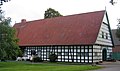
There are numerous typical Westphalian farms in the municipality . The high agricultural yield on the fertile loess soils led to courtyard buildings with rich ornaments, e.g. B. entablature carvings and the typical geck posts on the top of the gable. The farm with the greatest tax force in the village was given house number 1, the second largest house number 2, etc. These old house numbers are still often carved into the entablature today. A typical Ravensberger Hof was not in a closed village, but isolated in a hubbub . Numerous outbuildings (e.g. the Heuerlings - Kotten ) surrounded the main courtyard and formed a building complex. Every yard group used to have a peasant bell . Today such bells are still preserved in Bieren-Stukenhöfen and in Bieren-Dono, whereby the bell in Bieren-Dono is attached to a rather atypical steel structure. As everywhere in the Ravensberger Land, the half-timbering is mostly black, the infills are white, the gable is mostly dark green (less often white) and the roof tiles are red. Examples are the four-stand Hof Oberschulte with old divider from 1729 in the center of Rödinghausen or the Heerhof, which was first mentioned in 1603 and was built in its current form from 1820. The farms often also had a mill, e.g. B. The still existing water mill of the Böckel estate from 1756.
The Möllering farm stood in the Rödinghausen district until 1972. This was built in 1590 and can be viewed today in the Farmhouse Museum in Bielefeld , where it is shown as an example of a typical Westphalian farmhouse. The house was badly damaged in a fire in the museum in 1995, but could be rebuilt by 1999.

Donoer peasantry bell
Court high school

Four-stand courtyard in beers


Parks
Spa gardens
With 4.5 hectares the largest park is the spa park in the districts of Rödinghausen and Schwenningdorf, where the spa park lighting took place every summer until 2008. The spa park was created in the 1960s when the municipality first applied for the title of climatic health resort , and was completed in 1981 with the construction of the concert pavilion. The focal point is the large pond and the wooden arch bridge that spans it. A rose variety called Rose Rödinghausen also grows in the spa gardens .
Böckel Manor Park
The park of Gut Böckel, which is rarely accessible to the public and is a listed building, was created at the end of the 19th century. It is surrounded by a moat and consists of a geometrically laid out part and a two-hectare landscaped park with beautiful old solitary trees. The garden was designed in 1890 by the garden architect Rudolph P. C. Jürgens. The park has been part of the European Garden Heritage Network since 2005 . In summer, international artists present their art in the Ostwestfalen-Lippe garden landscape project . Emilia Kabakov's installation Meet the Angel has been a permanent exhibition in the park since 2003.
Natural monuments and nature reserves


The Rödinghausen landscape includes numerous centuries-old oaks and linden trees that characterize the landscape. The more than 350 year old Bierener Kirchlinde with its trunk circumference of 7.75 meters is outstanding . Rödinghausen's five nature reserves are the Kilverbachtal , in which some specimens of the rare, colorful kingfisher still live, the Gehle , the Auebach valley and its neighboring valleys, Wehmerhorster Wiesental and Schierenbeke . In addition, there is a share of the Habighorster Wiesental . Including this area, around 191.73 hectares or 5.29% of the municipal area are under protection.
Sports
.jpg)
The best-known sports club is SV Rödinghausen , whose first men's soccer team has played in the fourth-class Regionalliga West since the 2014/15 season . SV Rödinghausen usually plays its home games in the Häcker-Wiehenstadion . The stadium in the Schwenningdorf district was opened in 2011 and offers 1,500 covered seats on its main stand.
Other sports clubs are the table tennis club TTC Rödinghausen, the sports club TuS Bruchmühlen, the karate club Asahi Rödinghausen, the handball teams of the CVJM Rödinghausen and the tennis club TC Rödinghausen e. V. The first women's and men's teams of the TC Rödinghausen play in the summer and winter series in the Westphalia League. The TC Rödinghausen plays its home games in the tennis facility in Rödinghauser Kurpark and in Wiehenpark . The Wiehe Park is a sports center with a gym, sauna , indoor tennis courts, squash -Plätzen and gastronomy. Other sports fields besides the Häcker-Wiehenstadion and its artificial turf side area are located in Bieren and on the Fichten in Ostkilver, which is used by TuS Bruchmühlen. The community maintains an outdoor pool (50-meter pool, water slide and beach volleyball court) in the Bruchmühlen district. The only larger sports hall is that of the comprehensive school in Schwenningdorf with an external tartan sports field and running track. The Auenquelle stud farm is located in the district of Bieren. Its horse pastures shape the townscape of Bieren-Dono and successfully breed horse racing horses.
Regular events
- Literature and music festival Paths through the country at Gut Böckel in summer
- Christmas in the stable , a Christmas market at Gut Böckel during the Christmas season
- Russian Summer concert series at Gut Böckel
- The Ostwestfalen-Lippe garden landscape project with a sculpture exhibition at Gut Böckel in summer
- Kilver Market with rides, historic farmers market, and historic farming exhibitions; takes place annually in West Kilver on the last weekend in August
- During the spa park lighting in mid-August, the spa park in the Rödinghausen district is festively illuminated; the event ends every year with fireworks
- Regular cultural breakfasts in the guest house with readings, concerts and theater performances
theatre
The community does not have a permanent theater or theater stage. The theater group of the Rödinghausen comprehensive school occasionally performs plays in the school auditorium and at the cultural breakfast .
Ränkhiuser Platt
Standard German is spoken in Rödinghausen. In the past, however, as everywhere in the Ravensberger Land, a variant of Westphalian called Ostwestfälisch or Ravensberger Platt was spoken. Rödinghausen is called in Ravensberger Platt Ränghiusen . In order not to let the Ravensberger Platt be forgotten, church services are sometimes held in Rödinghausen in Low German , pupils from the comprehensive school learn Low German in a working group, and as part of the cultural breakfast there is the Low German Discussion Group , which started in 2007 with the event 25 years Ränkhiuser Platt - that's what you want! celebrated its anniversary. A small Low German dictionary from Rödinghausen and the surrounding area documents the Low German spoken in Rödinghausen (see Bibliography ). An extensive example of the dialect in the Ravensberger Land is, for example, the text Der Bauernhof um 1870 .
Culinary specialties
Rödinghausen has no nationally known specialty. Rödinghausen traditionally cooks hearty Westphalian dishes . However, for the Wiehengebirgsorte Preußisch Oldendorf, Rödinghausen and Bad Essen the herbal liqueur Wiehengebirgstropfen is distilled, which, like the Steinhäger, is offered in a 0.7 liter stoneware bottle. There is also a praline called Nonnenstein .
Economy and Infrastructure


Economic data
At the end of November 2006 the unemployment rate in Rödinghausen was 5.1 percent and in 2006 it was the lowest unemployment rate in the Herford district . The number of jobs subject to social security contributions (full-time employees) rose from 2254 to 2435 from 1995 to 2005. As a result, the municipality achieved 1236 euros in tax income per inhabitant in 2005 (third highest value after Steinhagen and Verl in Ostwestfalen-Lippe ). Nevertheless, the community of Rödinghausen was indebted in 2003 with 1907 euros per capita (second highest debt in the Herford district). The 4421 households in Rödinghausen had a relatively high purchasing power compared to the rest of East Westphalia. Studies by the GfK and IHK Bielefeld showed a purchasing power of 18,578 euros per inhabitant for 2007 (2.9 percent above average for all OWL municipalities and cities). The employees in Rödinghausen mainly work in the secondary sector . The following table shows the allocation of jobs on June 30, 2005.
| sector | Primary | Secondary | Tertiary |
|---|---|---|---|
| proportion of | 2.2% | 66.7% | 31.1% |
traffic
Rail and bus transport
The Bieren-Rödinghausen and Mesch Neue Mühle stops are on the Ravensberger Bahn , on which the RB 71 Bielefeld - Herford - Bünde - Rahden runs every hour, every two hours on Sundays . The Bieren-Rödinghausen station was completely renovated in 2007 and received a new platform and bus shelter north of the previous stop. The old station building has not been used for rail purposes since the 1980s.
In addition, the Bruchmühlen station on the Löhne – Rheine railway line is located in the immediate vicinity of the municipal boundary in the town of Melle in the Osnabrück district in Lower Saxony , on the hourly RB 61 Wiehengebirgs railway from Hengelo - Bad Bentheim - Rheine - Osnabrück –Bünde – Herford – Bielefeld wrong. The Mell city buses of the Verkehrsgemeinschaft Osnabrück also stop in Bruchmühlen .
Local rail passenger transport on the Ravensberger Bahn is carried out by the Eurobahn , which uses Bombardier Talent diesel multiple units here . The company Westfalenbahn operates the Wiehengebirgs-Bahn with an electric multiple unit type Stadler Flirt .
There are two bus routes in local road transport that also connect the individual districts:
- Line 542/543 via Bieren and Muckum to Bünde
- Line 571 via Bruchmühlen and Ahle or Holsen to Bünde
Usually (except in the morning and during school time) these run as taxi buses .
Rödinghausen belongs to the Westphalian tariff. The Bruchmühlen train station in Lower Saxony is not included in the network. The Lower Saxony tariff and the flat-rate tickets of the NRW tariff apply to rail transport . Depending on the direction, tickets for the tariff association Osnabrück ( VOS ) or the Westphalian tariff are issued on the buses .
Street
Rödinghausen is linked to the A 30 Amsterdam - Bad Bentheim - Rheine - Osnabrück - Bünde - Bad Oeynhausen highway network via Landesstraße 557 , which is also called Hansastraße . The L557 runs from Stemwede via Preußisch Oldendorf , Bünde and Enger to Bielefeld through a cut in the Wiehen Mountains in the Schwenningdorf district. In addition, Bünder Straße (L876) and Osnabrücker Straße (L546), both of which cross the community from east to west and connect Rödinghausen with the central center of Bünde in the east and the Lower Saxony town of Melle in the west, run through Rödinghausen.
Established businesses

The largest resident companies are active in the furniture industry. The kitchen manufacturers Häcker in Bieren with> 1500 employees and Ballerina (250 employees) in Bruchmühlen should be mentioned in particular . There are also companies from all sectors. Many Rödinghausers are commuters and work in Bünde or Lübbecke , for example . In 2002, 2,952 Rödinghausers commuted to work in other municipalities. In return, only 1,659 employees commuted to Rödinghausen.
tourism


Rödinghausen has been a climatic health resort since 1980 and, due to its location in the Northern Teutoburg Forest-Wiehengebirge nature park, is a popular holiday destination with numerous guest houses and hotels. The Rödinghausen Youth Hostel is located in the Rödinghausen district . The municipality recorded 28,390 overnight stays in 2015 (- 26.7 percent compared to the same period in the previous year). The community is attractively located on the southern edge of the Wiehengebirge and therefore advertises with the slogan "Rödinghausen - on the sunny side of the Wiehengebirge" or "Rödinghausen - on the sunny side" for short. The tourist information is located in the guest house , where numerous concerts and other events are held. On the 25.5 kilometers of the cycle culture route , tourists can discover the most beautiful landscapes and a total of 38 sights of the municipality. The Teutoburg Forest Wellness Route cycle path , the HF5 cycle route, the Weser-Lippe BahnRadRoute , the Westphalian farm route and the Else-Werre cycle path also run through the community . Hikers can explore the flora and fauna of the Wiehengebirge on the Rödinghausen educational forest trail with 100 boards and a length of 5.5 kilometers.
media


The daily newspapers are the Neue Westfälische and the Westfalen-Blatt with a local section for Rödinghausen. The local radio station, Radio Herford, can be received on 94.9 MHz.
Public facilities
The community has set up a public library in the Rödinghausen comprehensive school. Public events are often held in the guest's house . Other public facilities are the outdoor swimming pool and the youth hostel , which are, however, supported by the Herford district. The volunteer fire brigade Rödinghausen with fire fighting groups in several districts consists only of volunteer fire fighters.
education
In Rödinghausen there are three primary schools in Bieren, Bruchmühlen and Rödinghausen. The Rödinghausen comprehensive school (850 students) with secondary levels I and II in the Schwenningdorf district has been the community's only secondary school since 1991. It is the successor to the secondary school at the same location. About 30% of the primary school students in the community attend secondary schools outside the community, especially in nearby Bünde. Events at the Herford Adult Education Center are also offered in Rödinghausen .
Personalities
Honorary citizen
The entrepreneur and patron Horst Finkemeier was made an honorary citizen in 2020.
Sons and daughters of the church
In Rödinghausen were born:
- Ernst Wilhelm Georg Heinrich von Korff zu Waghorst (1792–1860), Prussian government official
- Hertha Koenig (1884–1976), writer and art collector
- Elisabeth Coester (1900–1941), glass painter and paramentist
- Otto Coester (1902–1990), professor of free graphics at the Düsseldorf Art Academy
- Erwin Möller (1924–2005), teacher, linguist and instrument maker
- Ingo Nentwig (1960–2016), sinologist and ethnologist
Other personalities
Also lived and worked in Rödinghausen:
- The lords of the Rödinghauser estates were u. a. the families Vincke , Voss , Vinckes and von dem Bussche .
- The soldier king Friedrich Wilhelm I of Prussia took quarters in Haus Kilver.
- The theologian and historian Johann Gottfried Hoche was a preacher in Rödinghausen from 1799 to 1800.
- The later Reich Bishop of the German Evangelical Church , Ludwig Müller , was parish priest in Rödinghausen from 1908 to 1914.
- The poet Rainer Maria Rilke spent the summer of 1917 at Gut Böckel.
- Auxiliary Bishop Matthias König of the Archdiocese of Paderborn was pastor in Rödinghausen / Holsen.
- The singer CC Catch lived for a few years in the Schwenningdorf district.
- The author Karl Röttger was a teacher in Schwenningdorf.
- The farmer and plant breeder Carl-Heinrich Roemer died in Rödinghausen in 2000.
- The entrepreneur Gustav Delius owned the Böckel estate and died there in 1872. His son Hermann Delius inherited the estate.
- The entrepreneur Leopold Koenig bought Gut Böckel and bequeathed it to his son Carl Koenig
literature
- Rolf Botzet: The Bartholomäus Church in Rödinghausen. A brief description of their history and works of art . Brochure. Rödinghausen community, Rödinghausen 2003, ISBN 3-9801709-8-5 .
- Rolf Botzet: Rödinghausen - The monuments - evidence of art, culture and nature . Brochure. Rödinghausen community, Rödinghausen 1991, ISBN 3-9801709-2-6 .
- Rolf Botzet: Farmers and home workers. Field work and house trade in the Ravensberger Land . Hardback edition. Rödinghausen community, Rödinghausen 1992, ISBN 3-7869-0289-5 .
- Rolf Botzet: Events, Merckworthy Keys and Entehbenheyten from Rödinghausen. On the occasion of the 100 years of independence of the office / community Rödinghausen from the previously unpublished material . 2nd edition (hardcover). Rödinghausen community, Rödinghausen 2002, ISBN 3-9801709-0-X .
- Ewald Häcker: Small Low German dictionary of Rödinghausen and the surrounding area . Brochure. Adult education center in the Herford district. Herford 1991.
- Adolf Schüttler: Rödinghausen in the Ravensberger Land. Ecological - economic structures and changes. Self-published community Rödinghausen, Rödinghausen o. J.
Others
- A rose variety bred for the community anniversary is named after Rödinghausen and grows in the spa gardens.
Individual evidence
- ↑ Population of the municipalities of North Rhine-Westphalia on December 31, 2019 - update of the population based on the census of May 9, 2011. State Office for Information and Technology North Rhine-Westphalia (IT.NRW), accessed on June 17, 2020 . ( Help on this )
- ↑ Schüttler, A. (n.d.), pp. 8-24
- ↑ Geological Service NRW: Using geothermal energy - Geothermal study provides planning basis ( Memento from September 14, 2005 in the Internet Archive ) (PDF; 369 kB)
- ↑ a b Rödinghausen municipal profile ( Memento of the original from April 7, 2014 in the Internet Archive ) Info: The archive link was inserted automatically and has not yet been checked. Please check the original and archive link according to the instructions and then remove this notice. , PDF, State Office for Data Processing and Statistics, as of 2012
- ↑ Council folder , PDF, Annex 1: Excerpt from the district map, Rödinghausen community, as of July 3, 2006
- ↑ Martin Bünermann: The communities of the first reorganization program in North Rhine-Westphalia . Deutscher Gemeindeverlag, Cologne 1970.
- ↑ Locations , html, Rödinghausen community, reference date for population figures unclear
- ↑ Meteorological information. Archived from the original on June 19, 2007 ; accessed on May 22, 2014 . , html, State Office for Data Processing and Statistics, access date: July 2, 2007
- ↑ a b Schüttler, A. (no year), pages 25-28
- ↑ a b c d e f Botzet, R. (1988): Ereygnisse, Merckworthigkeyten and Begehbenheyten from Rödinghausen. On the occasion of the 100 years of independence of the office / community Rödinghausen from the previously unpublished material . 2nd Edition. Rödinghausen community. Rödinghausen 1988. ISBN 3-9801709-0-X
- ↑ a b c d e Streiflichter from Rödinghausen , HTML, Alan Nabring, 1999
- ↑ Martin Bünermann: The communities of the first reorganization program in North Rhine-Westphalia . Deutscher Gemeindeverlag, Cologne 1970, p. 75 .
- ↑ Law on the reorganization of the district of Herford and the independent city of Herford of December 12, 1968
- ↑ Municipal statistics of the state of North Rhine-Westphalia: population development 1816–1871 . State Statistical Office of North Rhine-Westphalia, Düsseldorf 1966, pp. 190–194
- ↑ Municipal statistics of the state of North Rhine-Westphalia: population development 1871–1961 . State Statistical Office of North Rhine-Westphalia, Düsseldorf 1964, pp. 376–384
- ↑ a b Structural data for Rödinghausen ( Memento of the original from November 18, 2007 in the Internet Archive ) Info: The archive link was automatically inserted and not yet checked. Please check the original and archive link according to the instructions and then remove this notice. , PDF, State Office for Data Processing and Statistics North Rhine-Westphalia, State database NRW, status 2007
- ↑ Pupils at general education schools in North Rhine-Westphalia according to religious affiliation ( Memento from December 18, 2005 in the Internet Archive ), PDF, State Office for Data Processing and Statistics, as of 2002/03
- ↑ About WiR Wir in Rödinghausen eV, as of December 19, 2013
- ↑ State database NRW; Election results for the municipality code 05758028
- ^ State Office for Information and Technology in North Rhine-Westphalia: Local elections
- ^ Regional Returning Officer North Rhine-Westphalia
- ^ Community Rödinghausen: The Fritschendorfern given a sponsor community
- ↑ Excerpts from the Westphalian Farm Route Cycle Tour ( Memento from August 27, 2006 in the Internet Archive ), DOC, Rolf Botzet, Media Center of the Herford district, retrieved on: July 1, 2007
- ^ Regional Association Westphalia-Lippe: Kurpark Rödinghausen in LWL-GeodatenKultur
- ^ Regional Association Westphalia-Lippe: Gutspark Böckel in LWL GeodatenKultur
- ↑ The farm around 1870, Heinrich Stolte, PDF (130kb) ( Memento from September 30, 2007 in the Internet Archive )
- ↑ 1,100 delicious nun stones, PDF, article in the Neue Westfälische, November 30, 2006 ( Memento from September 29, 2007 in the Internet Archive )
- ^ Greetings from the Mayor of Rödinghausen at the turn of the year 2006/2007 - Lowest unemployment rate in the district , HTML, Ernst-Wilhelm Vortmeyer, Rödinghausen community website, December 2006
- ^ Structural data in the Detmold district, PDF, Detmold district government, as of October 2006. (PDF) (No longer available online.) Formerly in the original ; accessed on May 22, 2014 . ( Page no longer available , search in web archives ) Info: The link was automatically marked as defective. Please check the link according to the instructions and then remove this notice.
- ↑ Location satisfaction in the Herford district - results of the company survey 2003 , PDF, IHK Ostwestfalen zu Bielefeld, status 2003
- ↑ Purchasing power study by the IHK Bielefeld and GFK , PDF, as of 2007
- ↑ Commuters and labor market centrality ( Memento from September 29, 2007 in the Internet Archive )
- ↑ Tourist accommodation in North Rhine-Westphalia January - December 2015. (PDF 159kb) Information and Technology North Rhine-Westphalia, March 8, 2016, accessed on June 7, 2017 .
Web links
- Website of the community of Rödinghausen
- Rödinghausen in the Westphalia Culture Atlas
Frets | Narrower | Herford | Hiddenhausen | Kirchlengern | Wages | Rödinghausen | Spenge | Vlotho