Ravensberger Mulde
| location | |
|---|---|

|
|
| Basic data | |
| Federal states : | North Rhine-Westphalia and Lower Saxony |
| Superordinate natural area: |
Mittelgebirgsschwelle Niedersächsisches Bergland Lower Weserbergland |
| Highest mountains: |
256 m above sea level NN : stone burrows 165 m above sea level NN : Schweichler Berg |
| Deepest point: | 41 m above sea level NN (north Weser Valley ) |
| map | |

|
|
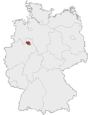
The Ravensberger Mulde (also: Ravensberger Hügelland ) is an area of 1021.3 km² in the northeast of North Rhine-Westphalia and, to a lesser extent, in the neighboring Lower Saxony . It is mainly located in the Detmold administrative region of East Westphalia-Lippe .
In the natural division of Germany, it is a main 4th order unit and part of the 3rd order Greater Region of Lower Saxony Uplands . It encompasses the hilly basin landscape between Wiehengebirge in the north, Lipper Bergland in the east, Teutoburg Forest in the south and Osnabrück hill country in the west. The core area of the Ravensberger Mulde is almost congruent with the area of the cultural landscape of the Ravensberger Land .
Demarcation
The delimitation of a natural area can only rarely be made unambiguously and linearly, as different features ( terrain and climate , soil, geology , water balance, flora and fauna) are taken into account and different results can be obtained depending on their weighting. This also applies to the Ravensberger Mulde, as there are transition areas to the neighboring natural areas, especially to the east.
To the north, south and south-west, on the other hand, the boundaries of the hill country can be clearly defined; they are here at the clearly identifiable foothills of the Wiehengebirge and Teutoburg Forest. The Osnabrück hill country joins to the west, there is no such sharp transition here. The dividing line runs roughly west of the Mell districts of Buer , Mitte and Wellingholzhausen . In the east and south-east there is a close connection with the Lipper Bergland. The closest possible border follows the Werre (from Lage ) and is initially about 2 km to the west, from Herford to the east and from Löhne up to 8 km south of the river bed. Sometimes the flatter western parts of the Lipper Bergland are also counted as part of the Ravensberger Mulde, rarely also the hilly country south of the Westphalian Gate , which is already beyond the Weseraue .
In the Ravensberger Mulde, all or most of the municipalities of the Herford district are located, except Vlotho , the independent city of Bielefeld (northern half with city center), Bad Oeynhausen and Hüllhorst (both in the Minden-Lübbecke district ), Leopoldshöhe ( Lippe district ), Werther ( district Gütersloh ) and Melle in Lower Saxony ( Osnabrück district ). In a broader sense, the area of the Lippe municipalities of Bad Salzuflen , Detmold , Dörentrup , Lage, Oerlinghausen ( Helpup district ) and Lemgo as well as Porta Westfalicas can be included in whole or in part.
Natural structure
The Ravensberger Hügelland is divided from north (west to east) to south (west to east) as follows:
- (to Lower Saxony highlands )
-
(to 53 Lower Weserbergland)
- 531 Ravensberg hill country
- 531.0 Quernheim hills and mountains (north)
- 531.00 Meesdorf Heights
- 531.01 Quernheim hill country
- 531.1 Else Werre lowland (middle)
- 531.2 Herford hill country (south)
- 531.20 Krukum-Bünder plateau and hill country
- 531.21 Oeynhausen hill country
- 531.22 Neuenkirchen hill country
- 531.23 Herford plateau and hill country
- 531.24 Stieghorster Osning foreland
- 531.0 Quernheim hills and mountains (north)
- 531 Ravensberg hill country
Natural features
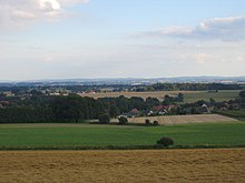
The Ravensberger Mulde is a gently undulating, between 50 and 140 m above sea level. NN lying hilly country , which is clearly framed by the surrounding, up to 300 m high mountain countries.
Numerous small box valleys formed by human hands (so-called sieves ) often cut suddenly and deeply into the otherwise poorly contoured land. Before the human intervention, the numerous streams had already created numerous V-valleys and transformed the once flat area into a hilly landscape comprising many flat, shield-shaped ridges and knolls. Farmers have widened most of these valleys to create pastureland by digging the plagues of grass, which were used for fertilization and as fodder, into the level and often right-angled sieves and relocated any watercourses in them to the edge of the valley. Since the valleys are still moist - even without a watercourse - they are mainly used as pastureland. The original V-valleys are only preserved in the few remaining forest areas. One example of this is the nightingale valley .
In the subsurface there are mainly lias plates (clay slate) that were deposited around 180 million years ago on the bottom of a shallow, warm sea and have a correspondingly large number of fossils such as ammonites , snails and shells. The Liastones are covered by sand, loam and gravel, which, however, rarely come to light. Over the impermeable Liastonen - the area is therefore moist to the ground - this scree-containing cover layer was formed in the Quaternary by ice-age ice cover and ice shifting. Other legacies of the Ice Ages are the boulders that are often found and often come from Scandinavia . During the last Ice Age ( Vistula Glaciation ), starting around 70,000 years ago, a closed layer of loess , on average one to five meters thick, was deposited over these layers . The area is one of the loess-covered Börde, which also includes the Jülich, Soester and Magdeburg Börde. Loess is a porous, moisture-storing, light and easy-to-work brown earth, which is quite poor in lime due to leaching, but is one of the most fertile arable soils overall.
The area is almost entirely drained by the Werre and its tributaries, of which the Else and Aa are the most important. In fact, the Ravensberger Mulde is in the broader sense, apart from the edge areas of the low mountain range, largely congruent with the area of the Else-Werre river system. However, the upper reaches of the Werre and the area of its tributary Bega , although similarly structured hill country, are mostly counted as part of the Lipper mountain country.
The Elsetal and the lower course of the Werre form the low-lying glacial valley of the Else-Werre-Niederung , which is also known as the Osnabrück valley , which runs in a west-east direction . The fertile loess was washed away from the lower terraces on both sides of the Else and Werre rivers, and sand, loam and rubble (terrace gravel) was washed ashore. In some cases, however, the old valley floor, the ground moraine or Lias claystone come to light. The soils are far less fertile than the loess hill country. Most of the wet floodplains stretch directly along the rivers. Before they were straightened and dyed, they were regularly flooded by the meandering rivers in front of them and are therefore covered by a layer of clay up to two meters thick.
North of the Osnabrück valley, the Quernheimer Bucht (also: Quernheimer Hügelland ) gradually rises to the foot of the Wiehengebirge. The wide, low-lying area adjacent to the south is called Herford Bay or Herford Mulde .
The highest areas of the Ravensberger Mulde are located with layers of around 150 to over 200 m on the edges, where the low mountain ranges connect. 256 m are reached on the Steinegge in the transition area to the Lipper Bergland. A little more in the core area is the Schweichler Berg with 165 m height, which, however, geologically considered as part of the Herford Keupervorsprungs is also a continuation of the Lipper Bergland, but is still counted as a hilly country due to its location west of the Werre.
The climate is atlantic . The predominant natural forest community is that of the oak - hornbeam forest .
See also: Climate in Ostwestfalen-Lippe
Settlement history
The predominantly fertile soils and the protected location between the low mountain ranges led to early settlement and intensive agricultural use in the Ravensberger Mulde, whereby the original vegetation has almost completely given way to a small-scale cultural landscape . The convenient location between Bielefelder Pass and Porta Westfalica promoted trade and economy. Proto- industrialization began in the early modern period with the linen trade as the basis; it was replaced in the 19th century by intensive and diverse industrialization . Today the landscape is one of the most densely populated areas in Germany.
Nature reserves
| designation | Mountain / mountain part / municipality | surface | district | Coordinates |
|---|---|---|---|---|
| In wiping | Melle | 12 ha | Osnabrück | 52 ° 14 ′ 18 ″ N , 8 ° 26 ′ 12 ″ E |
Individual evidence
- ^ A b Emil Meynen , Josef Schmithüsen : Handbook of the natural spatial structure of Germany . Federal Institute for Regional Studies, Remagen / Bad Godesberg 1953–1962 (9 deliveries in 8 books, updated map 1: 1,000,000 with main units 1960).
- ↑ a b Various authors: Geographical land survey: The natural space units in single sheets 1: 200,000 . Federal Institute for Regional Studies, Bad Godesberg 1952–1994. → Online maps
literature
- Adolf Schüttler: The Ravensberger Land . Aschendorff, Münster 1986.
- Emil Meynen (Hrsg.): Handbook of the natural spatial structure of Germany. Self-published by the Federal Institute for Regional Studies, Remagen 1959–1962 (Part 2, contains delivery 6–9), DNB 451803167
Web links
- BfN landscape profile, non-compacted outside areas of the Ravensberge Mulde
- BfN landscape profile, compacted core area (here with Bad Salzuflen)
- Ecological characterization
See also
- Ravensberg county
- Ravensberger Land
- Ravensberg Castle
- Minden-Ravensberg (old administrative unit)
Coordinates: 52 ° 7 ′ N , 8 ° 40 ′ E


