
Hüllhorst
| coat of arms | Germany map | |
|---|---|---|

|
Coordinates: 52 ° 17 ' N , 8 ° 40' E |
|
| Basic data | ||
| State : | North Rhine-Westphalia | |
| Administrative region : | Detmold | |
| Circle : | Minden-Lübbecke | |
| Height : | 115 m above sea level NHN | |
| Area : | 44.7 km 2 | |
| Residents: | 13,032 (Dec. 31, 2019) | |
| Population density : | 292 inhabitants per km 2 | |
| Postal code : | 32609 | |
| Primaries : | 05744, 05741 | |
| License plate : | MI | |
| Community key : | 05 7 70 016 | |
| LOCODE : | DE HHT | |
| Community structure: | 8 districts | |
| Address of the municipal administration: |
Löhner Strasse 1 32609 Hüllhorst |
|
| Website : | ||
| Mayor : | Bernd Rührup ( SPD ) | |
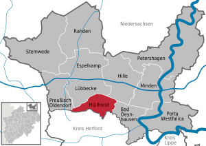
| Location of the municipality of Hüllhorst in the Minden-Lübbecke district | ||
  |
||

Hüllhorst [ ˈhʏlhɔʁst ] ( Low German : Hüllhuost ), officially the municipality of Hüllhorst , sometimes also a large municipality. Hüllhorst is a municipality in North Rhine-Westphalia , Germany , and belongs to the Minden-Lübbecke district in East Westphalia-Lippe .
geography
Geographical location

The municipality is located in the northeast of North Rhine-Westphalia, in the south of the East Westphalian district of Minden-Lübbecke . The municipality is naturally located in the hilly landscape of the Ravensberger Mulde . The municipality is bounded in the north by the Wiehengebirge , on the ridge of which mainly the borders with the city of Lübbecke run , in the west also with the city of Preußisch Oldendorf , in the extreme southwest to the municipality of Rödinghausen and in the far east to the municipality of Hille . With the Heidbrink , 320 m above sea level. NN, the municipality of Hüllhorst, together with Lübbecke, has the highest peak of this mountain range. The 315 meter high Kniebrink lies entirely on Hüllhorst territory. Overall, however, only a narrow, between 200 and 500 meters wide strip of the wooded Wiehengebirge belongs to the municipality, as these mountains are typical Pultschollengebirge and slopes gently to the north, but steeply to the south. The most important crossings in the Wiehengebirge are the Kahlewart and the B239 on the Reineberg, but neither of them represent a real incisive pass in the mountains.
The majority of the municipality is part of the Ravensberger Mulde , a predominantly hilly and crumpled basin landscape. Numerous valleys ( sieves ) formed by human hands cut into the landscape, sometimes suddenly. A well-known valley is the Nachtigallental , which lies in the border area of the districts of Büttendorf, Hüllhorst and Oberbauerschaft south of the small village of Hobrink . The entire municipality falls continuously to the south. Therefore, the area is mainly drained to the south towards the Werre . The most important tributary in the area of the municipality is the Rehmerloh-Mennighüffer Mühlenbach and its tributary Tengerner Bach . In the south near Huchzen the municipal area drops to a height of around 65 meters.
The closest major cities are Bielefeld (30 kilometers south) and Osnabrück (50 kilometers west).
geology

The Ravensberger Mulde consists predominantly of clay marl , limestone and sandstones from the Middle Ages ( Triassic , Jurassic and Chalk ). The one to two kilometer thick sediments were lifted out in the course of the earth's history and broken up into saddles , hollows , clumps and ditches by mountain-forming processes . In this fracture-fold mountain range , the rock layers that used to be undisturbed one above the other are now arranged next to one another and in some cases also in tipped over storage. In the deeper subsurface the rocks of the ancient times ( Devonian , Carboniferous , Permian ) can be found.
Due to the complicated geological structure of the municipality, there are great qualitative differences in the groundwater resources. Because of the salinisation of the deeper subsoil ( rock salt and gypsum ), many water resources cannot be used as drinking water.
The municipal area consists of large areas of fertile arable soils ( parabroun earths ) that have arisen from loess . Sandy-loamy to loamy-clayey brown soils have arisen primarily through weathering.
From south to north, Hüllhorst is increasingly medium to very good for the use of geothermal heat sources by means of geothermal probes and heat recovery through heat pump heating (see also the adjacent map).
Expansion and use of the municipal area
The municipality occupies an area of 44.73 km². The area extends quite elongated along the Wiehen Mountains. The maximum east-west extension is about 11 km. The largest north-south extension is about 5 km.

The fertile loess landscape encouraged intensive agricultural use early on. For this reason, there are only remnants of forests, mainly in the numerous valleys z. B. the Benkhöfer Bruch and in the mountainous Wiehengebirge. In contrast to the coniferous forests of the Wiehengebirge, the forests in the valleys are mainly deciduous and coppice forests. These are also called "bushes" by the locals (e.g. Rehbusch and others). Most of the grassland is located in these valleys, which is mostly used as pasture and is pronounced as Siek. The loess-covered plateaus are used up to the mountain forest of the Wiehengebirge. The following table shows the exact land use.
|
Area according to type of use |
Settlement and traffic areas |
Agricultural area |
Forest area |
other open spaces |
|---|---|---|---|---|
| Area in hectares | 872 | 2,963 | 581 | 57 |
| Share of total area | 19.5% | 66.2% | 13.0% | 1.2% |
Neighboring communities
The neighboring communities are in a clockwise direction in the west, Preußisch Oldendorf , Lübbecke , Hille , Bad Oeynhausen (all Minden-Lübbecke district), Löhne , Kirchlengern , Bünde and Rödinghausen (all Herford district ).
Community structure

According to the main statute § 1, the municipality of Hüllhorst consists of the following localities :
| Locality | Residents |
The localities of the municipality of Hüllhorst  |
|---|---|---|
| Ahlsen-Reineberg | 881 | |
| Broderhausen | 655 | |
| Büttendorf | 777 | |
| Holsen | 1,026 | |
| Hüllhorst | 2,806 | |
| Upper peasantry | 2,988 | |
| Schnathorst | 2,702 | |
| Tengern | 1,976 | |
Population figures as of December 31, 2018.
These localities largely correspond to the formerly independent municipalities, which in 1973 were combined to form the municipality of Hüllhorst in accordance with the Bielefeld Act of October 24, 1972 as of January 1, 1973. Only the formerly smallest municipality in the state of North Rhine-Westphalia, Huchzen (45 inhabitants as of December 31, 2006), did not receive any status as a locality, but was assigned to the locality of Tengern.
climate
The climate in Hüllhorst is determined by its location in the ocean-continental transition area of Central Europe and by its location in the Ravensberger Mulde. The area is mostly in the sub-Atlantic maritime climate , but has temporary continental influences . The winters are mostly mild under the influence of the Atlantic, the summers are moderately warm and the rainfall is relatively evenly distributed. The annual mean temperature is around 8.5 ° C, although the altitude influences this. The elevations of the Wiehengebirge are around 0.5 ° C cooler. Precipitation is significantly influenced by the sheltered location in the basin. The Teutoburg Forest and the Eggegebirge shield the Ravensberger Mulde from the damp weather fronts coming from the Atlantic from the preferred wind direction south-west. The mean annual rainfall is around 750 mm. For concrete monthly values, reference is made in particular to Rödinghausen , which is located in a comparable natural area and is neighboring .
history

Today's municipality of Hüllhorst was created in a regional reform under the Bielefeld Act of October 24, 1972 on January 1, 1973. The individual districts, however, have been documented for a long time. Most of today's localities are first mentioned in the 11th and 12th centuries:
- Ahlsen-Reineberg: first attested in 1290. The foundation of the district of the domain Reineberg belonging to the diocese of Minden and its castle Reineberg probably goes back to the year 1220. Reineberg Castle was probably completed by 1230, but was demolished in 1723.
- Bröderhausen: The village was first mentioned in a document in 1250
- Büttendorf: first mentioned in a document in 1042
- Holsen: first mentioned in a document in 1260
- Hüllhorst: first attested in 1290
- Upper farmers: The origins go back to the first documented entry of the municipality of Beendorf in 1121. Later five districts, including Beendorf, were merged and given the name of upper farmers. Upper peasantry is first mentioned in a document at the beginning of the 17th century.
- Schnathorst: First mentioned in writing in 1244
- Tengern: first mentioned in 1151
A settlement developed in place of the demolished Reineberg Castle. The old office in Reineberger Feld existed from 1723 to 1807 and belonged to the Prussian principality of Minden . In 1648 the diocese of Minden became a secular principality and became part of Prussia . Between 1807 and 1813 the area was de facto French. First as part of the Kingdom of Westphalia ( Département du Weser ), from 1811 directly to France ( Département de l'Ems-Supérieur ). After the end of the French period, the area first became part of the Prussian district of Bünde in 1815 . After its dissolution, the area of today's municipality in 1832 became part of the Rahden district (at the same time renamed: Lübbecke district ). From 1843 onwards, the municipalities in what is now the municipality were combined in administrative terms in the Schnathorst Office (renamed the Hüllhorst Office from 1849). Legally, the nine member communities (Huchzen still independent) remained fully independent. Since the municipal reform in 1973, the newly founded large community within the boundaries of the old office has belonged to the Minden-Lübbecke district . A naming of the community in the community of Reineberg was discussed but rejected.
In earlier times, the area of today's municipality of Hüllhorst had almost exclusively rural populations, those in the fertile Ravensberg hill country . The textile trade initially developed as an additional source of income. In proto-industrialist homework, flax was spun and woven into the famous Ravensberger linen . With the advent of mechanical looms, this form of employment became unprofitable. From around 1860 a flourishing cigar production developed in the Ravensberger Land and in Hüllhorst . This industry saw its decline after World War II .
religion

At the latest after the secularization of the Principality of Minden and the beginning of membership in Protestant Prussia from the 17th century, the area is predominantly Evangelical-Lutheran . There is a separate parish in Schnathorst, Oberbauerschaft and Hüllhorst. The origins of the Hüllhorst church (Andreaskirche) go back to the year 1510. An even older missal from 1310 is mentioned in the vicinity of the church, so that the parish Hüllhorst celebrated its 650th anniversary in 1960. There is also a Baptist brotherhood in the upper peasantry.
An indication of the distribution can be the denomination of the Hüllhorst students. According to this, around 70 percent of the students are Protestant, four percent each Catholic and Islamic. 16 percent say they belong to another denomination and six percent do not belong to any denomination.
Incorporations
Today's municipality of Hüllhorst was created in a regional reform under the Bielefeld Act of October 24, 1972 on January 1, 1973. For this purpose, the municipalities of the Hüllhorst office were combined. Seven of today's eight localities were previously independent communities. Tengern was later enlarged by the formerly independent Huchzen, which is no longer an official part of the municipality of Hüllhorst.
Population development
The following overview shows the population of the municipality of Hüllhorst according to the respective territorial status, with some figures also according to the current territorial status. The figures are census results from 1818 to 1970 and 1987, and from 1975 official updates from the State Office for Data Processing and Statistics . The figures from 1975 to 1985 are estimated values, the figures from 1990 are extrapolations based on the results of the 1987 census. From 1871 and 1946, the figures relate to the local population , from 1925 to the resident population and from 1985 to the population at Location of the main residence . Before 1871, the population figures were determined using inconsistent survey methods.
Hüllhorst according to the territorial status at that time

|
|
Hüllhorst according to the current territorial status
|
|
Municipalities of the Hüllhorst office (corresponds roughly to the current territorial status)
|
|
politics
Municipal council
The municipal council of Hüllhorst currently has 32 seats. In addition, the mayor is the council chairman. The following table shows the local election results since 1975:
| 2014 | 2009 | 2004 | 1999 | 1994 | 1989 | 1984 | 1979 | 1975 | ||||||||||
|---|---|---|---|---|---|---|---|---|---|---|---|---|---|---|---|---|---|---|
| Political party | Seats | % | Seats | % | Seats | % | Seats | % | Seats | % | Seats | % | Seats | % | Seats | % | Seats | % |
| CDU | 14th | 44.3 | 15th | 45.45 | 15th | 48.81 | 16 | 48.67 | 14th | 40.59 | 13 | 35.74 | 14th | 41.33 | 15th | 44.57 | n / a | 44.69 |
| SPD | 14th | 42.1 | 13 | 40.85 | 13 | 40.30 | 14th | 43.09 | 16 | 47.36 | 18th | 51.69 | 17th | 47.27 | 16 | 47.62 | n / a | 43.87 |
| Green | 3 | 9.7 | 2 | 7.64 | 2 | 5.24 | 1 | 3.48 | 2 | 6.54 | 0 | 4.85 | 2 | 6.56 | - | - | - | |
| FDP | 1 | 3.9 | 2 | 6.06 | 2 | 5.65 | 1 | 4.76 | 1 | 5.51 | 2 | 7.72 | 0 | 4.83 | 2 | 7.82 | n / a | 6.06 |
| Others | - | - | - | - | - | - | - | - | - | - | - | - | - | - | - | - | n / a | 5.38 |
| Total 1 | 32 | 100 | 32 | 100 | 32 | 100 | 32 | 100 | 33 | 100 | 33 | 100 | 33 | 100 | 33 | 100 | n / a | 100 |
| voter turnout | 55.1 | 62.68 | 66.60 | 64.83 | 84.81 | 76.26 | 77.85 | 80.47 | 89.42 | |||||||||
1 without taking into account rounding differences
mayor
The full-time mayor of the municipality of Hüllhorst is Bernd Rührup (SPD). He was elected in the mayoral election on September 13, 2015. His term of office began on October 21, 2015.
1st deputy mayor is Hans Hamel (SPD)
2nd Deputy Mayor: Karl-Heinz Kröger (CDU)
Further predecessors in the mayor's office (incomplete list):
- Friedhelm Kleine (CDU)
- Karl Schwarze (SPD) (1984–1999)
- Wilhelm Henke (SPD) (1999-2015)
coat of arms
The district president granted the municipality the right to use a coat of arms on October 15, 1973. According to the main statute, § 2, the coat of arms is divided into gold (yellow) and red. The coat of arms shows a red two-tower tinned castle floating above, and below a horizontal bar cross angled by four golden (yellow) balls. The municipal coat of arms corresponds to the official coat of arms of the Hüllhorst office from 1938. The castle in the coat of arms is reminiscent of the old Mindener Amtsburg Reineberg , which was formerly located in the northern part of the municipality and was demolished in the 17th century. The lower part shows the coat of arms of the von Schloen family called Tribbe. This family had lived on Gut Husen since the 14th century .
The municipality's flag has red and yellow stripes and also shows the municipality's coat of arms moved from the center to the front.
Town twinning
A partnership with the municipality of Ingelmunster ( Belgium ) has existed since 1979 . The communities meet every year for cultural and sporting events in the respective partner community.
Culture


theatre
There are two theater associations in the parish. The open-air stage Kahle Wart on the mountain Kahlewart ( 286 m ) in the village of Oberbauerschaft mainly shows plays in Low German and the creative group "Walk in" from the CVJM Hüllhorst puts on musicals and plays every year.
Museums
The Hüllhorst local history museum, founded in 1910, shows the history of the Hüllhorst community as well as archaeological finds from the community area. The exhibition of the local history museum Oberbauerschaft, set up as a private collection in 1989, shows exhibits from the village of Oberbauerschaft. These include a. Household items, rural costumes as well as pictures and documents on local history. Finally, the Schnathorst Toy Museum , which opened in 1997, shows around 500 dolls , dollhouses and accessories as well as over 1200 cars, tin toys , steam engines and trains, picture books and games from the period from 1830 to 1975 on 90 m² .
music
Members of the NRW Choir Association are the choirs: Cantiamo Hüllhorst , Mixed Choir Oberbauerschaft , Shanty Choir Ahlsen-Reineberg and Ilex-Singer Ahlsen-Reineberg . Trumpet choirs, church choirs and the gospel choir Joyful Gospels are active in the parishes . The two wind orchestras of the Dorfkapelle Oberbauerschaft and the Schnathorster wind orchestra make music . There is also a youth music school in the community.
Buildings
Mills
The municipality of Hüllhorst is the only municipality in the Minden-Lübbecke mill district to have all types of natural power mills (wind, water, animals / horses).
- The Husenmühle in the Nachtigallental : This water mill was mentioned as early as 1646 . For many years it was owned by the von Schloen family, whose ancestral home was the Husen estate . The mill in the 19th century mill building was in operation until 1962. It has an overshot water wheel with a diameter of four meters, which is driven by the water of the Lusbach . After the mill was closed, the building fell into disrepair. The new owner built the building true to the original on the well-preserved foundation walls and also renewed the mill equipment.
- Struckhof windmill in the Schnathorst district : The Wall-Holländer was built in 1883. The mill was only included in the mill maintenance program in 1987.
- The Rossmühle in the Oberbauerschaft district is the only mill of its kind in the Minden-Lübbecke mill district. The Rossmühle was built in 1797. Because of its size, equipment and the preserved original substance, this mill is a unique technical cultural monument beyond the border of Westphalia. The mill was built on the Meyer zu Kniedorf farm. The other buildings in the courtyard are also evidence of a long courtyard development.
Churches
- The Andreas Church in Hüllhorst, built 1870–1871. The tower of the old church was preserved, which was donated by Stacius von Tribben around 1310.
- The church in Schnathorst , built in 1901/02. It is the largest village church in the old Lübbecke district .
- The church in upper peasantry
The parishes of Hüllhorst, Schnathorst and Oberbauerschaft therefore belong to the community. The parish Oberbauerschaft only includes the district Oberbauerschaft itself. In addition to the district Hüllhorst, the parish Hüllhorst also includes Büttendorf and Ahlsen-Reineberg. In addition to Schnathorst, Tengern, Holsen and Bröderhausen also belong to the parish of Schnathorst.
Nature reserves
The only nature reserve in the municipality is the Benkhöfer Bruch . It is relatively small with an area of 8.8 hectares, was designated in 1993 and is located on the Mühlenbach near Büttendorf. The core area is a still water created by clay excavation with broken and alluvial forest-like vegetation on the Mühlenbach. In the vicinity, moist grassland areas are also protected. In this biotope there are numerous species of amphibians and dragonflies, as well as reed beds and sedges . This means that only relatively small parts of the municipality are protected. Furthermore, the municipality in the north has a share in the nature and geopark TERRA.vita (formerly: Nature Park Nördlicher Teutoburger Wald-Wiehengebirge).
Natural monuments
In the community, 16 individual trees and groups of trees are designated as natural monuments.
Sports
The HSG Hüllhorst ( handball community) has the largest youth department in the Minden-Lübbecke district. The first men's team and the first women's team of the HSG play in the association league. Other clubs are the TuS Tengern (1st team plays in the national soccer league), the SV Hüllhorst-Oberbauerschaft, the SV Schnathorst, SV Blau-Weiß Oberbauerschaft and the Holsener Sportverein. Tennis clubs are located in Schnathorst and Tengern.
Regular events
The home and harvest festival has been held in Oberbauerschaft since 1933 , with a parade every five years. The Tengern May celebration with parade has been held annually on May 1st since 1950. On the first Advent there was the Bunte Adventstrasse Hüllhorst since 1983 . This was discontinued in 2015. The song festival in Hüllhorst is also worth mentioning. Until the beginning of the 1990s, the Schnathorst market, a fair, took place in Schnathorst.
Economy and Infrastructure
traffic

Today the municipality of Hüllhorst no longer has a connection to the rail network. There used to be a narrow-gauge railway ( Wallückebahn ) from Kirchlengern via Hüllhorst-Tengern and Hüllhorst-Schnathorst to Hille . This narrow-gauge railway was shut down in the 1930s for lack of profitability and then completely dismantled.
The federal highway 239 leads past Hüllhorst in a north-south direction on the western edge. From Hüllhorst there are regional buses to Löhne , Bad Oeynhausen and Lübbecke . A dial-a-bus connects the individual districts with one another. Hüllhorst belongs to the tariff association “Der Sechser” ( OWL Verkehr GmbH).
media
In Hüllhorst the Neue Westfälische and the Westfalenblatt are represented as regional newspapers with local sections for Hüllhorst. The local radio for the Minden-Lübbecke district is Radio Westfalica .
Public facilities

The community's voluntary fire brigade has around 130 active members and is divided into the fire fighting groups Tengern , Hüllhorst, Oberbauerschaft, Holsen, Schnathorst and Bröderhausen. The fire fighting groups have a total of nine vehicles.
The community has four village community houses, one each in Oberbauerschaft, Bröderhausen, Holsen and Schnathorst. The fire stations in Holsen and Bröderhausen are in the same building complex.
The cafeteria, cafeteria and auditorium (the so-called "Ilex-Halle") of the local comprehensive school can be used for social and informational events.
The waste from the municipality of Hüllhorst is disposed of in accordance with the Waste Act of the Federal Republic of Germany in the Pohlsche Heide waste disposal center .
education
The community offers five primary schools (in Ahlsen, Büttendorf, Oberbauerschaft, Schnathorst and Tengern) and a comprehensive school in Hüllhorst. Neighboring communities must be used for further offers.
In 2007, a total of 1,868 students were taught at the Hüllhorst schools with 126 teachers, 34.5% of them at primary schools and 65.5% at comprehensive schools.
There is also a youth music school in the Holsen district, and Hüllhorst is also a member of the Lübbecker Land community college .
Established businesses
In June 2004 around 2,700 citizens were employed in Hüllhorst subject to social security contributions. The largest employer is the computer manufacturer Wortmann AG with around 300 employees.
The clayey soil is used in the municipality as a raw material for bricks and the Meyer-Holsen company has been producing roof tiles from the local slate for 145 years .
The Deutsche Wurlitzer was based in Hüllhorst. The company manufactured jukeboxes and vending machines for many years . After production had ceased, the building was empty. Today a furniture production is located there.
In December 2010, the Kröning GmbH & Co., headquartered in the Tengern district, celebrated its 30th anniversary. The manufacturer of surfaces for the furniture industry (melamine resin edging and wrapping foils on the basis of special papers) is part of the listed Surteco SE and employs around 60 people.
The Jeans Fritz Handelsgesellschaft mbH for fashion is headquartered in Hüllhorst.
Personalities
sons and daughters of the town
- Karl-Hermann Meyer zum Büschenfelde (1929–2019), German doctor and professor
- Siegbert Wortmann (* 1955), German computer pioneer and entrepreneur
Personalities associated with the community
- Johann Heinrich Volkening , theologian, was a pastor in Schnathorst
- Johannes Kuhlo , church musician, was ordained in Hüllhorst
Others
Hüllhorst describes itself as Ilex-Stadt after the European holly (sleeve, Hulstbaum), to which the name probably goes back. A ilex leaf is an official mark and can be found everywhere in the cityscape. In addition to the Ilex hall, there is also an Ilex youth café, a private Ilex house, etc.
swell
- ↑ Population of the municipalities of North Rhine-Westphalia on December 31, 2019 - update of the population based on the census of May 9, 2011. State Office for Information and Technology North Rhine-Westphalia (IT.NRW), accessed on June 17, 2020 . ( Help on this )
- ↑ Geological Service NRW: Using geothermal energy - Geothermal study provides planning basis ( Memento from September 14, 2005 in the Internet Archive ) (PDF; 369 kB)
- ↑ Hüllhorst municipal profile ( Memento of the original from May 5, 2008 in the Internet Archive ) Info: The archive link was automatically inserted and not yet checked. Please check the original and archive link according to the instructions and then remove this notice. , PDF, State Office for Data Processing and Statistics, as of 2007
- ↑ Numbers & Dates. In: Website of the municipality of Hüllhorst. Hüllhorst community, accessed on April 7, 2019 .
- ^ City of Detmold: Climate Maps ( Memento from October 16, 2014 in the Internet Archive )
- ↑ State Office for Data Processing and Statistics: Schoolchildren at general education schools in North Rhine-Westphalia according to religious affiliation (archive version) ( Memento from December 18, 2005 in the Internet Archive )
- ^ Federal Statistical Office (ed.): Historical municipality directory for the Federal Republic of Germany. Name, border and key number changes in municipalities, counties and administrative districts from May 27, 1970 to December 31, 1982 . W. Kohlhammer, Stuttgart / Mainz 1983, ISBN 3-17-003263-1 , p. 324 f .
- ↑ State Statistical Office of North Rhine-Westphalia: Municipal statistics of the State of North Rhine-Westphalia: population development 1816–1871 . Düsseldorf 1966, p. 200
- ↑ State Statistical Office of North Rhine-Westphalia: Municipal statistics of the State of North Rhine-Westphalia: Population development 1871–1961 . Düsseldorf 1964, pp. 408-409.
- ↑ State Statistical Office of North Rhine-Westphalia: The resident population in the municipalities of North Rhine-Westphalia 1970: Results of the census on May 27, 1970 . Düsseldorf 1972, p. 42.
- ^ State Office for Data Processing and Statistics North Rhine-Westphalia: Special series on the 1987 population census in North Rhine-Westphalia, Volume 1.1: Population, private households and employed persons . Düsseldorf 1989, p. 128.
- ^ State Office for Data Processing and Statistics North Rhine-Westphalia: State database North Rhine-Westphalia
- ↑ State database NRW; Election results for the municipality code 05770016
- ^ State Office for Information and Technology in North Rhine-Westphalia: Local elections
- ↑ http://wahl.krz.de/kw2015/05770016/html5/index.html >
- ↑ Neue Westfälische on September 6, 2008: To Hüllhorst / made a contribution / Former Mayor Karl Schwarze died at the age of 80
- ↑ New Westphalian old mayor Wilhelm Henke adopts edition of November 18, 2015
- ↑ Directory of natural monuments. (PDF, 347 kB) Minden-Lübbecke district, lower landscape authority, accessed on April 8, 2019 .
- ↑ State Office for Data Processing and Statistics North Rhine-Westphalia: Hüllhorst municipal profile ( Memento of the original from May 5, 2008 in the Internet Archive ) Info: The archive link was automatically inserted and not yet checked. Please check the original and archive link according to the instructions and then remove this notice.
- ↑ Press portal: Deutsche Wurlitzer rescued ( page no longer available , search in web archives ) Info: The link was automatically marked as defective. Please check the link according to the instructions and then remove this notice. Edition of September 11, 2013, accessed August 5, 2015
literature
- Eckhard Struckmeier: "How the deer thirsts for fresh water ...": History of the parish Hüllhorst from the Middle Ages to the present VML Vlg Marie Leidorf 1996. ISBN 3-89646-900-2
- Parish Schnathorst (Ed.): Since 1425 parish Schnathorst . Self published in 1980.
- Heimatverein Tengern-Huchzen eV (Hrsg.): Life in Tengern. Community with tradition and future. Self-published. Tengern 2000.
Web links
- Website of the municipality of Hüllhorst
- Hüllhorst in the Westphalia Culture Atlas
Cities: Bad Oeynhausen | Espelkamp | Lübbecke | Minden | Petershagen | Porta Westfalica | Prussian Oldendorf | Rahden . Municipalities: Hille | Hüllhorst | Stemwede .