
Kniebrink
| Kniebrink | ||
|---|---|---|
 The Kniebrink seen from the south |
||
| height | 315 m above sea level NN | |
| location | North Rhine-Westphalia , Germany | |
| Mountains | Wiehengebirge | |
| Coordinates | 52 ° 17 '49 " N , 8 ° 39' 22" E | |
|
||

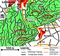
The Kniebrink is 315 m above sea level. NN the third highest mountain in the north German Wiehengebirge . Its immediate summit belongs administratively to the municipality of Hüllhorst , (here to the village of Oberbauerschaft ). However, the border with Lübbecke runs directly north of the summit, so that the northern roof already belongs to Lübbecke.
The height of the Kniebrink is three meters less than the height of the Wurzelbrink further north , which obscures it as seen from Lübbecke. The mountain is largely undeveloped. In spring 2007 the tree population suffered major storm damage. The ascent can be accomplished from Lübbecke in under 45 minutes. From the south, the short but steep ascent takes around 20 minutes.
Until the regional reform in 1973, the Kniebrink belonged to the city of Lübbecke. With the regional reform, an approximately 57 hectare forest strip belonging to Lübbecke (today's district 032 in the Oberbauerschaft 2783 corridor) was added to the community of Hällhorst (here the Oberbauerschaft district). Until 1973 the old town of Lübbecke reached beyond the ridge to the southern edge of the forest against the upper farmers; the border was also moved back to the Kammweg here. In return, Lübbecke received the Reineberger Hagen .

Lübbecke district. Map section (1844). Kniebrink in the area of what was then Lübbecke. (Municipal boundaries blue). Former city limits to the edge of the forest against the upper farmers.
Kniebrink immediately south of the Wurzelbrink
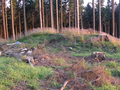
On the forestless summit region, the highest point, this hill, is easily identified as the actual summit

Today, large stocks of foxgloves are spreading across the summit region deforested by storm
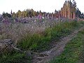
Path to the top
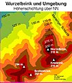
In addition to the Wurzelbrink, the Kniebrink also exceeds the 300 m mark


