Reineberger Hagen

The Reinberger Hagen , also Reinbergerhagen , formerly also Reinebergischer Hagen , is a predominantly wooded area around the Reineberg mountain or around the former Reineberg castle in the Wiehengebirge in the area of the city of Lübbecke . The Reineberger Hagen, which also includes the site of the former Reineburg, has an area of 0.99 km². Until the territorial reform in 1973 , it belonged to the southern municipality of Ahlsen-Reineberg in the Hüllhorst department at that time and formed an area corridor that reached north to the Obere Tilkenbreite, almost within walking distance of the historic old town of Lübbeckes. In the course of the regional reform it then fell to the city of Lübbecke. The mountain ridge (more precisely the ridge path) has since formed the southern border to the municipality of Hüllhorst and the Hüllhorst district of Ahlsen-Reineberg. In the southeast corner, the Reinberger Hagen borders the Lübbeck district of Gehlenbeck , otherwise its outer border is also completely in the area of the core city. The area is between 132 meters above sea level (in the north at the Upper Tilkenbreite) and 311.6 meters above sea level. NN (near the summit of the Heidbrink, which itself is just outside the area). Until 1807, the Reinberger Hagen was part of the Schnathorst Vogtei in the Principality of Minden . From 1815 to 1831 it belonged to the district of Bünde , which after its dissolution was largely merged into the district of Herford, with the exception of the later office of Hüllhorst, which (together with Reinberger Hagen) was affiliated to the then newly created district of Lübbecke.
Todays situation
The Reineberger Hagen is now completely in the area of the Lübbeck core town . The former affiliation to the municipality bordering today to the south is echoed in the name part "Reineberg" of today's district Ahlsen-Reineberg and also by the fact that the Hüllhorst municipality still has an image of Reineburg in its coat of arms.
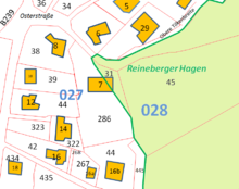
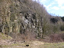
The Reinberger Hagen is also a street name of a street on the western edge of the area, south of the Barre Bräu brewery . Today it corresponds to the Lübbecke parcel 2771 028. The Reinberger Hagen is largely forested. The only larger forest-free areas, apart from temporary clearings due to forestry, are, on the one hand, the approximately one-hectare forest sports field with a parking lot and the approximately two-hectare area of a former quarry in the southwest not far from the B239 federal road. Otherwise, the people of Lübbeck are hardly aware today that the area with "their" local mountain , the Reineberg, did not belong to the city of Lübbecke for centuries.
use
The main, if not the only, infrastructure is the Lübbecker forest sports field, including the hiking car park. Although this is a regular sports field, it is particularly unusual due to its location, surrounded by forest. The sports field is primarily the regular sports facility of the nearby Wittekind high school , but it is also used by other local sports clubs.
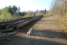
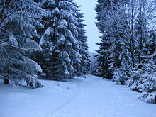
The Reineberger Hagen is otherwise mainly used for forestry and is looked after by the regional forest office of Ostwestfalen-Lippe . The deciduous forest dominates; around 33 hectares of coniferous forest (these are particularly in the south around the Heidbrink and a smaller area north of the Meesenkopf) contrasts with around 64 hectares of beech deciduous forest. There is no agricultural use, the few natural meadows are only grazed by wild animals. High seats are used for hunting purposes. In addition, the Reinberger Hagen serves as a local recreation area, especially for the residents of Lübbeck, for whom this part is the closest area of the Wiehengebirge to the city. The network of paths is relatively close-meshed and partly paved, some paths even have a closed tar surface. However, only the short driveway to the car park of the forest sports ground is open to public transport. The well-paved path from the south to the telecommunications tower serves only as a supply path for the same and, like all other forest paths, may only be used by specially authorized persons.
The Kammweg, which marks the border to the south, is part of the Wittekindsweg , which in turn is part of the European long-distance hiking trail E 11 . The entire Reineberger Hagen belongs to the nature and geopark TERRA.vita .
Effects / other
The forest portion of the city of Lübbecke is currently 20.02 percent of the land area, making it the relatively most forested municipality in the Minden-Lübbecke district. Without the affiliation of the Reineberger Hagens, the forest area would be around 99 hectares smaller, the proportion of Lübbecke forest would be only 18.7 percent and Lübbecke would not have this top position in terms of forest wealth (the neighboring municipality of Preussisch Oldendorf would have this with 19.5 percent forest share). The opposite is true for the municipality of Hüllhorst: the proportion of forests with the Reineberger Hagen would be 15.2 percent instead of the current 13.0 percent.
The assignment of the Reinberger Hagens to the city of Lübbecke happened against the will of the community of Ahlsen-Reinberg at the time. In addition to the considerable loss of territory, the area of the community or the then district was reduced from 5.15 km² to 4.16 km² by around a fifth, and the castle grounds of the former Reinburg with the "thick linden tree" had and still has in one chronicle it is said that the Doppeldorf had an "indispensable historical significance" and was "deeply mourned" by contemporaries beyond the Wiehenkamm - but there is also something comforting: In 1926 the city of Lübbecke applied to the community of Ahlsen-Reineberg to To maintain the thick linden tree on the Reinberg, because the city fathers were concerned that this former natural monument would perish, but were not responsible because it was not on Lübbeck territory. The Ahlsen-Reinberg municipal council had discussed the application and also determined that it was "desirable to preserve the tree, which dates back to historical times"; Nevertheless, the application was rejected because they did not want to have the not insignificant costs alone. It is now comforting for Ahlsen-Reinberg that Lübbecke has been responsible for such matters since 1973. Nevertheless, it should be noted that in the sum total for today's municipality of Hüllhorst and the city of Lübbecke, the loss or gain of territory was relative, because with the territorial reform, not only the Reineberger Hagen Lübbecke, but also an approximately 57 hectare forest strip belonging to Lübbecke ( the current district 032 in the corridor Oberbauerschaft 2783) was added to the community of Hällhorst (here the district Oberbauerschaft): The old town of Lübbecke extended beyond the ridge to the southern edge of the forest against the Oberbauerschaft until 1973; the border was also moved back to the Kammweg here. So there was an exchange of territory in which the new city of Lübbecke, or the core city of Lübbecke, gained only 42 hectares of forest in total, and Hüllhorst lost accordingly in total.
Residents and buildings
The area has practically no residents and hardly any buildings. In a certain way, the residents of the house at Osterstrasse 7 in Lübbecke are an exception. According to the property map, the property in question includes both parcel 286 in district 027 and parcel 31 in district 028, i.e. the district that corresponds to Reinberger Hagen, with the house itself exactly on the border of the parcels and around a third in Reineberger Hagen lies.
Other buildings are:
- The changing house and the garage for the high jump mat of the aforementioned forest sports field, (parcel 36)
- One building south of the address Reinberger Hagen 1
- Almost exactly on the border around 42 meters north of the trigonometric point 302.0 is the "Hut on the Heidbrink" or Heidbrinkhütte for short , at a height of just over 300 m . The small refuge is located on the Wittekindsweg ( Kammweg ) and thus on the European long-distance hiking trail E11. A predecessor of the hut was built in 1924, a successor hut before the reorganization, i.e. built before 1973, both still under the responsibility of the municipality of Ahlsen-Reinberg. The hut was renovated in 1984, now under Lübbecke's responsibility.
The telecommunications tower not far from the Heidbrink summit and the associated supply buildings are already just outside the area.
A structure with a certain relevance for hikers and mountain bikers is the Bunte Brücke , a wooden bridge over the Ronceva, which was renovated or rebuilt in 2017 after decades of deterioration.
mountains
The following mountains are wholly or partly in the area of the Reinberger Hagens:
- Reineberg
- Heidbrink (partly, the summit is outside)
- Heidkopf (partially)
- Meesenkopf (partially)
Waters
The only significant flowing waters are the Ronceva , the upper reaches of which graze the area to the west (around 300 meters) and the Oberdorfer Bach Tal in the valley floor between the Reineberg and the Heidkopf, which forms the border to the neighboring area in the east at 540 meters. The source of the latter is the Wittekindsquelle , which is shaped as a spring pot a few square meters in size. In addition to this, there is only one relevant and significantly larger still water, a pond of around 220 m² on the area of the former quarry.
The Reineberger Hagen is essentially drained via one of the mentioned streams, the watershed runs relatively centrally from north to south over the summit of the Reineberg to the Heidbrink.
Geology / quarries
During a water drilling between the Heidbrink and the Reineberg in 1928 the following layers were found:
- up to 1 m: yellow clay
- up to 6.4 m: brown, iron-lumped coarse sandstone
- up to 18 m: fine-grained, blue-gray limestone, layers of slate at the bottom
- up to 42 m: the same, even more slate pitches
- up to 62 m: weak sandy, chalky slate clay
The sandstone is porta sandstone (also called brown stone). This sandstone only occurs in the immediate region in the eastern Wiehen Mountains: at the Weser breakthrough at Porta Westfalica, the sandstone bank is up to 20 meters thick. About 4 to 5 kilometers west of the breakthrough, the thickness decreases to 10 meters and east of Lübbecke to 4 to 8 meters, to finally wedge out completely at Lübbecke, i.e. west of the Reineberger Hagens (gradual reduction in thickness to 0 m, further west to the northern slopes of the Kniebrink, the Breitenbrink, the Blasheimer Berg and the Alten Verbrenn and on the Offelter Berg a maximum of 1 meter) The quarries near Lübbecke am Reineberger Hagen around 1769 may no longer have been recognizable around 1844. It is therefore not purely coincidental that the westernmost important quarry of the Wiehengebirge, which was still in operation in modern times, was in Reineberger Hagen, although no Portasandstein was mined there - to the west of today's federal highway 239, there is, directly on this next to the Mensinger Gorge , just a small abandoned quarry.
Many of the former quarries on the Reineberger Hagen up to the Heidbrink, in which Portasandstein was mined, are barely recognizable today and are partly overgrown. The thickness of the layer is given as three meters, the mining is said to have taken place "around 1767" and between 1873 and 1900. The east gable of St. Andrew's Church in Lübbecke (1883–1885), the Protestant church in Alswede (1878 and 1893) and the church in Hüllhorst (1870/71) were demonstrably built with Reinberger Hagener Portasandstein .
References and comments
- ↑ Historical map, the Reineberger Hagen is located in the southwest
- ↑ Martin Bünermann, Heinz Köstering: The communities and districts after the municipal territorial reform in North Rhine-Westphalia . Deutscher Gemeindeverlag, Cologne 1975, ISBN 3-555-30092-X , p. 116 .
- ^ Heimatkreis Singkreis Ahlsen-Reineberg eV (Ed.): 700 years of Ahlsen. 1290 - 1990, Hille-Eickhorst, 1990, p. 85.
- ↑ The Reineberger Hagen on Straßenweb
- ↑ See the corresponding property map on Tim Online NRW
- ↑ Measured using a winter aerial photo on TIM-Online
- ^ Heimatkreis Singkreis Ahlsen-Reineberg eV (Ed.): 700 years of Ahlsen. 1290 - 1990, Hille-Eickhorst, 1990, p. 64 and p. 85.
- ↑ See property map of the corresponding address, freely available on TIM-Online NRW - the border of the Reineberger Hagens is z. B. on a scale of 1: 1.742 as either blue or purple broken line
- ↑ Note: The hut is now around five meters outside the Lübbecke district 2771 in the Gehlenbeck area 2734 , i.e. outside the area that is defined in the article as "Reinberger Hagen", and the border with the municipality of Hüllhorst runs on the southwest edge of the hut the ridge path. However, there is evidence that the hut was in the area of responsibility of the municipality of Ahlsen-Reinberg before 1973, i.e. it belongs to the area that was reclassified to Lübbecke in 1973 and can therefore, in a broader sense, be considered part of the Reineberger Hagens.
- ↑ Altitude of the Heidbrinkhütte on the German basic map
- ^ Heimatkreis Singkreis Ahlsen-Reineberg eV (Ed.): 700 years of Ahlsen. 1290 - 1990, Hille-Eickhorst, 1990, p. 81.
- ↑ Picture of the wooden panel at the Heidbrinkhütte
- ↑ Size of the area determined on Google Earth and Tim-Online
- ^ Heimatkreis Singkreis Ahlsen-Reineberg eV (Ed.): 700 years of Ahlsen. 1290 - 1990, Hille-Eickhorst, 1990, p. 47
- ↑ [1]
- ↑ Table 5 ( page no longer available , search in web archives ) Info: The link was automatically marked as defective. Please check the link according to the instructions and then remove this notice.


